

Highways in Croatia
Encyclopedia
Croatia
Croatia , officially the Republic of Croatia , is a unitary democratic parliamentary republic in Europe at the crossroads of the Mitteleuropa, the Balkans, and the Mediterranean. Its capital and largest city is Zagreb. The country is divided into 20 counties and the city of Zagreb. Croatia covers ...
.
The Croatian classification includes several classes of highways:
- The main motorways are named A (autocesta) accompanied by one or two digits. By and large they are toll highways with a ticket systemTicket systemA ticket system toll road A ticket system toll road A ticket system toll road (also known as closed toll collection system, as opposed to a flat-rate toll road, is utilized by some state toll road or highway agencies that allows a motorist to pay a toll rate based on the number of miles traveled...
. - Expressways (brza cesta) are limited-access roadLimited-access roadA limited-access road known by various terms worldwide, including limited-access highway, dual-carriageway and expressway, is a highway or arterial road for high-speed traffic which has many or most characteristics of a controlled-access highway , including limited or no access to adjacent...
s with grade-separated intersections and by and large an increased speed limit while no tolling. They remind of the motorways, but aren't always dual carriagewayDual carriagewayA dual carriageway is a class of highway with two carriageways for traffic travelling in opposite directions separated by a central reservation...
s, they have no emergency lanes, and their speed limit is always lower. They either have standalone designations or are parts of major state routes (D), see below. - Roads dedicated for motor vehicles (cesta namijenjena isključivo za promet motornih vozila), which is a category for highways which are limited-access roadLimited-access roadA limited-access road known by various terms worldwide, including limited-access highway, dual-carriageway and expressway, is a highway or arterial road for high-speed traffic which has many or most characteristics of a controlled-access highway , including limited or no access to adjacent...
s, usually similar to multiple-lane motorways/expressways, but which may have slow intersections. It has no specific naming convention, only a dedicated traffic signTraffic signTraffic signs or road signs are signs erected at the side of roads to provide information to road users. With traffic volumes increasing over the last eight decades, many countries have adopted pictorial signs or otherwise simplified and standardized their signs to facilitate international travel...
, and it mainly includes major state routes (D) or portions thereof, see below. An example is the Jadranska AvenueJadranska AvenueJadranska Avenue is a mostly six-lane controlled-access avenue in the Novi Zagreb – zapad city district of southwestern Zagreb, Croatia. Legally designated as a part of County road Ž1040, it runs between the Remetinec Roundabout and the Zagreb bypass, acting as an important thoroughfare both...
in Zagreb, designated as Ž1040 county road.
Other than these, the national road classification includes the following categories which may also be referred to as highways in a general sense, with decreasing order of priority (and applicability of the term highway):
- State roads, which are marked by letter D (državna cesta) and a single, double or triple digit number.
- County roads always are marked by letter Ž (županijska cesta) and a four digit number.
- The lowest classification comprises local roads, marked by letter L (lokalna cesta) and a five digit number.
Road operators differ according to the classification system: The designated motorways are operated by four different concessionaires. The state roads are maintained almost exclusively by Hrvatske ceste
Hrvatske ceste
Hrvatske ceste is a Croatian state-owned company pursuant to provisions of the Croatian Public Roads Act , the county and local roads are managed by county authorities, while the motorways are managed by Croatian Motorways Ltd and other concessionaires.The company is currently administered by a...
, while the county and local roads are managed by various county
Counties of Croatia
The primary territorial subdivisions of the Republic of Croatia called županije . In English they are commonly referred to as counties....
authorities. The road maintenance agencies are governed by various laws issued by the Parliament as well as bylaws issued by the Ministry of Transport.
Motorways

Highway
A highway is any public road. In American English, the term is common and almost always designates major roads. In British English, the term designates any road open to the public. Any interconnected set of highways can be variously referred to as a "highway system", a "highway network", or a...
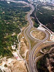
can be any main road, and the terms motorway (British English) and freeway (American English) would be more precise. As of September 2010 Croatian motorway network is 1124.9 kilometres (699 mi) long.
Motorways in Croatia are defined by the Ministry of Sea, Transport and Infrastructure. The same applies to names of the motorway interchanges and rest areas. Likewise, the same legislation defines the origin of motorway chainages - at the northern or the western terminus of the motorway - and the motorway markings themselves. The markings are defined as consisting of letter "A" and the motorway number assigned by the legislation, except if a specific motorway is executed in construction stages and considered an expressway, in which case the applicable motorway number is preceded by letter "B" instead.
Generally, the motorways in Croatia are developed and maintained by the state-owned company Hrvatske autoceste (Croatian Motorways Ltd). There are several exceptions to this, namely Zagreb (Lučko) - Bosiljevo 2 section of the A1 motorway
A1 (Croatia)
The A1 motorway is the longest motorway in Croatia spanning . As it connects Zagreb, the nation's capital, to Split, the second largest city in the country and the largest city in Dalmatia, the motorway represents a major north–south transportation corridor in Croatia and a significant part of the...
, the A6
A6 (Croatia)
The A6 motorway is a motorway in Croatia spanning . It connects the nation's capital, Zagreb, via the A1, to the seaport of Rijeka. The motorway forms a major north–south transportation corridor in Croatia and is a part of European route E65...
and the A7
A7 (Croatia)
The A7 motorway is a long motorway in Croatia. It connects the nation's largest port in Rijeka, to the Croatian motorway network, as well as to the Rupa and Pasjak border crossings to Slovenia. The motorway forms part of a longitudinal transportation corridor in Croatia, and it is a part of...
motorways which are managed by Autocesta Rijeka - Zagreb (Rijeka - Zagreb Motorway), the A2 motorway
A2 (Croatia)
The A2 motorway is a motorway in the Hrvatsko Zagorje region of northern Croatia, connecting Zagreb to the Macelj border crossing and Slovenia. The A2 motorway is part of the European route E59 and the Pan-European Corridor Xa...
, managed by Autocesta Zagreb - Macelj (Zagreb - Macelj Motorway) and the A8 and the A9 motorways which are managed by BINA Istra
BINA Istra
BINA Istra is a Croatian joint stock company founded in 1995 to facilitate construction and subsequent management of a Istrian Y motorway, consisting of the A8 motorway and the A9 motorway. On September 21, 1995, BINA Istra has been granted concession regarding management of the Istrian Y...
.
List of completed motorways
| Motorway | County | Length | Description | Notes |
|---|---|---|---|---|
| A1 A1 (Croatia) The A1 motorway is the longest motorway in Croatia spanning . As it connects Zagreb, the nation's capital, to Split, the second largest city in the country and the largest city in Dalmatia, the motorway represents a major north–south transportation corridor in Croatia and a significant part of the... |
Zagreb Zagreb County Zagreb County is a county in central Croatia. It surrounds – but does not contain – the nation's capital Zagreb, which is a separate territorial unit. For that reason, it is often nicknamed "Zagreb ring"... , Karlovac Karlovac County Karlovac County is a county in central Croatia, with the administrative center in Karlovac.The city of Karlovac is another fort from the times of the Military Frontier... , Lika‑Senj Lika-Senj County Lika-Senj county is a county in Croatia that includes most of the Lika region and some northern coastline of the Adriatic near the town of Senj, including the northern part of the Pag island... , Zadar Zadar County Zadar County is a county in Croatia, it encompasses northern Dalmatia and southeastern Lika. Its center is the city of Zadar.- Population :According to the 2001 census, Zadar County has population of 162,045... , Šibenik‑Knin Šibenik-Knin County Šibenik-Knin County is a county in Croatia, located in north-central Dalmatia. Its center is Šibenik; other notable towns are Knin, Drniš and Skradin.... , Split‑Dalmatia Split-Dalmatia County Split-Dalmatia County is the central-southern Dalmatian county in Croatia. The administrative center is Split. The population of the county is 455,242... , Dubrovnik‑Neretva Dubrovnik-Neretva County The Dubrovnik–Neretva County is the southernmost Croatian county located in south Dalmatia. The county seat is Dubrovnik and other large towns are Korčula, Metković, Opuzen and Ploče... and the City of Zagreb |
465.5 km (289.2 mi) | The A1 starts in Lučko interchange Lučko interchange The Lučko interchange is a stack interchange in Zagreb, Croatia. It is named after nearby Zagreb neighborhood of Lučko. The interchange represents the northern terminus of the A1 motorway and it connects the A1 route to the A3 motorway between Jankomir interchange and Buzin exit, also representing... , a part of Zagreb bypass Zagreb bypass Zagreb bypass , is an U-shaped motorway partially encircling Zagreb, Croatia. The largest part by far, between Jankomir and Ivanja Reka interchanges, has been built between 1977 and 1979, while Ivanja Reka - Sveta Helena section has been built between 1996 and 1999. The bypass is long, tracing... where the A3 motorway A3 (Croatia) The A3 motorway is a major motorway in Croatia spanning . The motorway connects Zagreb, the nation's capital, to the Slavonia region and a number of cities along the Sava River. It represents a major east–west transportation corridor in Croatia and a significant part of the Pan-European Corridor... junction is found. The motorway proceeds south from Zagreb Zagreb Zagreb is the capital and the largest city of the Republic of Croatia. It is in the northwest of the country, along the Sava river, at the southern slopes of the Medvednica mountain. Zagreb lies at an elevation of approximately above sea level. According to the last official census, Zagreb's city... to Karlovac Karlovac Karlovac is a city and municipality in central Croatia. The city proper has a population of 49,082, while the municipality has a population of 59,395 inhabitants .Karlovac is the administrative centre of Karlovac County... and further on to Bosiljevo 2 interchange Bosiljevo 2 interchange The Bosiljevo 2 interchange |A6 motorway]] and it connects the A6 route to the A1 motorway between Bosiljevo 1 and Ogulin exits. The interchange is a part of Pan-European corridor Vb. It also represents a part of European route E65.- See also :... interchange where the A6 motorway A6 (Croatia) The A6 motorway is a motorway in Croatia spanning . It connects the nation's capital, Zagreb, via the A1, to the seaport of Rijeka. The motorway forms a major north–south transportation corridor in Croatia and is a part of European route E65... branches off towards Rijeka Rijeka Rijeka is the principal seaport and the third largest city in Croatia . It is located on Kvarner Bay, an inlet of the Adriatic Sea and has a population of 128,735 inhabitants... . The route continues south to Gospić Gospic Gospić is a town in the mountainous and sparsely populated region of Lika, Croatia. It is the administrative centre of Lika-Senj county. Gospić is located near the Lika River in the middle of a karst field.... , Zadar Zadar Zadar is a city in Croatia on the Adriatic Sea. It is the centre of Zadar county and the wider northern Dalmatian region. Population of the city is 75,082 citizens... , Šibenik Šibenik Šibenik is a historic town in Croatia, with population of 51,553 . It is located in central Dalmatia where the river Krka flows into the Adriatic Sea... , Split Split (city) Split is a Mediterranean city on the eastern shores of the Adriatic Sea, centered around the ancient Roman Palace of the Emperor Diocletian and its wide port bay. With a population of 178,192 citizens, and a metropolitan area numbering up to 467,899, Split is by far the largest Dalmatian city and... . The southernmost sector of the motorway proceeds from Split to Vrgorac Vrgorac Vrgorac is a town in Croatia in the Split-Dalmatia County.The total population of Vrgorac is 6,501 , in the following settlements:* Banja, population 214* Dragljane, population 47* Draževitići, population 204* Duge Njive, population 106... where the traffic proceeds to Ploče Ploce Ploče is a town and a notable seaport in the Dubrovnik-Neretva County of Croatia.The total population of Ploče is 10,102 , in the following settlements:* Baćina, population 564* Banja, population 176* Komin, population 1,222... and Dubrovnik Dubrovnik Dubrovnik is a Croatian city on the Adriatic Sea coast, positioned at the terminal end of the Isthmus of Dubrovnik. It is one of the most prominent tourist destinations on the Adriatic, a seaport and the centre of Dubrovnik-Neretva county. Its total population is 42,641... via the state road network. |
Additional sections under construction. |
| A2 A2 (Croatia) The A2 motorway is a motorway in the Hrvatsko Zagorje region of northern Croatia, connecting Zagreb to the Macelj border crossing and Slovenia. The A2 motorway is part of the European route E59 and the Pan-European Corridor Xa... |
Zagreb Zagreb County Zagreb County is a county in central Croatia. It surrounds – but does not contain – the nation's capital Zagreb, which is a separate territorial unit. For that reason, it is often nicknamed "Zagreb ring"... , Krapina‑Zagorje Krapina-Zagorje County Krapina-Zagorje county is a county in northern Croatia. It encompasses most of the historic region called Hrvatsko Zagorje.The Krapina-Zagorje county is a candidate for being the most idyllic county in Croatia: the many villages and small towns spread out across the hillsides are perfect for... and the City of Zagreb |
59.0 km (36.6 mi) | The A2 starts on the border of Slovenia Slovenia Slovenia , officially the Republic of Slovenia , is a country in Central and Southeastern Europe touching the Alps and bordering the Mediterranean. Slovenia borders Italy to the west, Croatia to the south and east, Hungary to the northeast, and Austria to the north, and also has a small portion of... near Macelj Macelj Macelj is the name of a village and a forest in northern Croatia bordering on Slovenia. There is an official border crossing in Macelj, and the end of the A2 highway.-Macelj in 1945:... . The motorway passes west of Krapina Krapina Krapina is a town in northern Croatia and the administrative centre of Krapina-Zagorje County with a population of 4,482 and a total municipality population of 12,479... and proceeds south towards Zagreb Zagreb Zagreb is the capital and the largest city of the Republic of Croatia. It is in the northwest of the country, along the Sava river, at the southern slopes of the Medvednica mountain. Zagreb lies at an elevation of approximately above sea level. According to the last official census, Zagreb's city... . The southernmost section of the motorway forms a part of Zagreb bypass Zagreb bypass Zagreb bypass , is an U-shaped motorway partially encircling Zagreb, Croatia. The largest part by far, between Jankomir and Ivanja Reka interchanges, has been built between 1977 and 1979, while Ivanja Reka - Sveta Helena section has been built between 1996 and 1999. The bypass is long, tracing... and it terminates in Jankomir interchange Jankomir interchange The Jankomir interchange is a cloverleaf interchange west of Zagreb, Croatia. It is named after nearby Zagreb neighborhood of Jankomir. The interchange represents the southern terminus of the A2 motorway and it connects the A2 route to the A3 motorway representing major a link in the Croatian... with the A3 motorway A3 (Croatia) The A3 motorway is a major motorway in Croatia spanning . The motorway connects Zagreb, the nation's capital, to the Slavonia region and a number of cities along the Sava River. It represents a major east–west transportation corridor in Croatia and a significant part of the Pan-European Corridor... . |
3.75 km (2.3 mi) as a semi-motorway. |
| A3 A3 (Croatia) The A3 motorway is a major motorway in Croatia spanning . The motorway connects Zagreb, the nation's capital, to the Slavonia region and a number of cities along the Sava River. It represents a major east–west transportation corridor in Croatia and a significant part of the Pan-European Corridor... |
Zagreb Zagreb Zagreb is the capital and the largest city of the Republic of Croatia. It is in the northwest of the country, along the Sava river, at the southern slopes of the Medvednica mountain. Zagreb lies at an elevation of approximately above sea level. According to the last official census, Zagreb's city... , Sisak‑Moslavina Sisak-Moslavina County Sisak-Moslavina County is a Croatian county in eastern Central Croatia and southwestern Slavonia. It is named after the city of Sisak and the region Moslavina just across the river Sava. According to 2001 census it is inhabited by 185 thousand people.... , Brod‑Posavina Brod-Posavina County Brod-Posavina County is the southern Slavonian county in Croatia. Its center is the city of Slavonski Brod and it spreads along the left bank of the Sava river, hence the name Posavina... , Vukovar‑Syrmia Vukovar-Syrmia County Vukovar-Syrmia county is the easternmost Croatian county. It includes the eastern parts of Slavonia and western parts of Syrmia regions; but also the lower Sava river basin .... and the City of Zagreb |
306.5 km (190.5 mi) | The A3 starts on the border of Slovenia Slovenia Slovenia , officially the Republic of Slovenia , is a country in Central and Southeastern Europe touching the Alps and bordering the Mediterranean. Slovenia borders Italy to the west, Croatia to the south and east, Hungary to the northeast, and Austria to the north, and also has a small portion of... near Bregana Bregana Bregana is a settlement in the Town of Samobor, Zagreb County, Croatia. According to the 2001 census, the town has 2,518 residents living in an area of . Together with the nearby settlements of Podvrh and Klokočevec Samoborski, the town's micropolitan area has 3,450 inhabitants.Together with... . The motorway passes north of Samobor Samobor Samobor is a town in the Zagreb County, Croatia. It is part of the Zagreb metropolitan area.-Geography:Samobor is located west of Zagreb, between the eastern slopes of the Samoborsko gorje , in the Sava River valley.-Population:... and proceeds west towards Zagreb Zagreb Zagreb is the capital and the largest city of the Republic of Croatia. It is in the northwest of the country, along the Sava river, at the southern slopes of the Medvednica mountain. Zagreb lies at an elevation of approximately above sea level. According to the last official census, Zagreb's city... , passing to the south of the city and forming a part of Zagreb bypass Zagreb bypass Zagreb bypass , is an U-shaped motorway partially encircling Zagreb, Croatia. The largest part by far, between Jankomir and Ivanja Reka interchanges, has been built between 1977 and 1979, while Ivanja Reka - Sveta Helena section has been built between 1996 and 1999. The bypass is long, tracing... , where the route contains junctions with the A2 A2 (Croatia) The A2 motorway is a motorway in the Hrvatsko Zagorje region of northern Croatia, connecting Zagreb to the Macelj border crossing and Slovenia. The A2 motorway is part of the European route E59 and the Pan-European Corridor Xa... , A1 A1 (Croatia) The A1 motorway is the longest motorway in Croatia spanning . As it connects Zagreb, the nation's capital, to Split, the second largest city in the country and the largest city in Dalmatia, the motorway represents a major north–south transportation corridor in Croatia and a significant part of the... and A4 A4 (Croatia) The A4 motorway is a motorway in Croatia spanning . It connects the nation's capital, Zagreb, to the city of Varaždin and to Budapest, Hungary via the Goričan border crossing. The motorway represents a major north–south transportation corridor in Croatia and is a part of European routes E65... motorways. It continues east to Kutina Kutina Kutina is a small city in central Croatia, the largest settlement in the hilly region of Moslavina, in the Sisak-Moslavina county. The town proper has a population of 14,814 , while the total municipality population is 22,815.... , Slavonski Brod Slavonski Brod Slavonski Brod is a city in Croatia, with a population of 59,507 in 2011. The city was known as Marsonia in the Roman Empire, and as Brod na Savi 1244–1934. It is the sixth largest city in Croatia, after Zagreb, Split, Rijeka, Osijek and Zadar. Located in the region of Slavonia, it is the... , Sredanci interchange Sredanci interchange The Sredanci interchange is a cloverleaf interchange west of Slavonski Brod, Croatia. It is named after nearby village of Sredanci. As of September 2011, the interchange represents the southern terminus of the A5 motorway and it connects the A5 route to the A3 motorway facilitating a link between... with the A5 motorway A5 (Croatia) The A5 motorway is a motorway in Croatia spanning . It connects Osijek, the largest city in Slavonia region, to the Croatian motorway network at the Sredanci interchange of the A3 motorway. The A5 represents a significant north–south transportation corridor in Croatia and is a part of the... and further east to Županja Županja Županja is a city in eastern Slavonia, Croatia, located 254 km east of Zagreb. It is administratively part of the Vukovar-Syrmia county. It is inhabited by 12,185 people .... and terminating on the border of Serbia Serbia Serbia , officially the Republic of Serbia , is a landlocked country located at the crossroads of Central and Southeast Europe, covering the southern part of the Carpathian basin and the central part of the Balkans... near Lipovac |
Entire route completed. |
| A4 A4 (Croatia) The A4 motorway is a motorway in Croatia spanning . It connects the nation's capital, Zagreb, to the city of Varaždin and to Budapest, Hungary via the Goričan border crossing. The motorway represents a major north–south transportation corridor in Croatia and is a part of European routes E65... |
Međimurje, Varaždin Varaždin County Varaždin County is a county in northern Croatia. It is named after its county seat, the city of Varaždin.-Geography:In addition to the city of Varaždin, the county includes the towns of Ivanec, Ludbreg, Lepoglava, Novi Marof and Varaždinske Toplice, as well as 22 municipalities... and Zagreb Zagreb County Zagreb County is a county in central Croatia. It surrounds – but does not contain – the nation's capital Zagreb, which is a separate territorial unit. For that reason, it is often nicknamed "Zagreb ring"... and the City of Zagreb |
96.4 km (59.9 mi) | The A4 starts on the border of Hungary Hungary Hungary , officially the Republic of Hungary , is a landlocked country in Central Europe. It is situated in the Carpathian Basin and is bordered by Slovakia to the north, Ukraine and Romania to the east, Serbia and Croatia to the south, Slovenia to the southwest and Austria to the west. The... near Goričan Gorican Goričan is a municipality in Međimurje County, Croatia.Goričan is the only village belonging to the municipality. Its population in the 2001 census was 3,148. Of the entire population, 3,088 people identified themselves as Croats.... . The motorway passes near Čakovec Cakovec Čakovec is a city in northern Croatia, located around 90 kilometres north of Zagreb, the Croatian capital. Čakovec is both the county seat and largest city of Međimurje County, the northernmost, smallest and most densely populated Croatian county.-Population:... and Varaždin Varaždin Varaždin is a city in north Croatia, north of Zagreb on the highway A4. The total population is 47,055, with 38,746 on of the city settlement itself . The centre of Varaždin county is located near the Drava river, at... south towards Zagreb Zagreb Zagreb is the capital and the largest city of the Republic of Croatia. It is in the northwest of the country, along the Sava river, at the southern slopes of the Medvednica mountain. Zagreb lies at an elevation of approximately above sea level. According to the last official census, Zagreb's city... and the southernmost part of the route is a part of Zagreb bypass Zagreb bypass Zagreb bypass , is an U-shaped motorway partially encircling Zagreb, Croatia. The largest part by far, between Jankomir and Ivanja Reka interchanges, has been built between 1977 and 1979, while Ivanja Reka - Sveta Helena section has been built between 1996 and 1999. The bypass is long, tracing... , where the motorway terminates in Ivanja Reka interchange Ivanja Reka interchange The Ivanja Reka interchange is a cloverleaf interchange east of Zagreb, Croatia. The interchange represents the southern terminus of the A4 motorway and it connects the A4 route to the A3 motorway representing major a link in the Croatian motorway system. The interchange is a part of Pan-European... , where the traffic defaults to the westbound A3 motorway A3 (Croatia) The A3 motorway is a major motorway in Croatia spanning . The motorway connects Zagreb, the nation's capital, to the Slavonia region and a number of cities along the Sava River. It represents a major east–west transportation corridor in Croatia and a significant part of the Pan-European Corridor... . |
Entire route completed. |
| A5 A5 (Croatia) The A5 motorway is a motorway in Croatia spanning . It connects Osijek, the largest city in Slavonia region, to the Croatian motorway network at the Sredanci interchange of the A3 motorway. The A5 represents a significant north–south transportation corridor in Croatia and is a part of the... |
Osijek‑Baranja Osijek-Baranja County Osijek-Baranja county is a county in Croatia, located in northeastern Slavonia and Baranja. Its center is Osijek; other cities include Đakovo, Našice, Valpovo, Belišće, Beli Manastir.-Administrative divisions:Osijek-Baranja county is divided into:... and Brod‑Posavina Brod-Posavina County Brod-Posavina County is the southern Slavonian county in Croatia. Its center is the city of Slavonski Brod and it spreads along the left bank of the Sava river, hence the name Posavina... |
55.0 km (34.2 mi) | The A5 starts near Osijek Osijek Osijek is the fourth largest city in Croatia with a population of 83,496 in 2011. It is the largest city and the economic and cultural centre of the eastern Croatian region of Slavonia, as well as the administrative centre of Osijek-Baranja county... and proceeds south bypassing Đakovo to Sredanci interchange Sredanci interchange The Sredanci interchange is a cloverleaf interchange west of Slavonski Brod, Croatia. It is named after nearby village of Sredanci. As of September 2011, the interchange represents the southern terminus of the A5 motorway and it connects the A5 route to the A3 motorway facilitating a link between... with the A3 motorway A3 (Croatia) The A3 motorway is a major motorway in Croatia spanning . The motorway connects Zagreb, the nation's capital, to the Slavonia region and a number of cities along the Sava River. It represents a major east–west transportation corridor in Croatia and a significant part of the Pan-European Corridor... . |
Additional sections planned. |
| A6 A6 (Croatia) The A6 motorway is a motorway in Croatia spanning . It connects the nation's capital, Zagreb, via the A1, to the seaport of Rijeka. The motorway forms a major north–south transportation corridor in Croatia and is a part of European route E65... |
Primorje‑Gorski Kotar Primorje-Gorski Kotar County Primorje-Gorski kotar County is a county in western Croatia that includes the Bay of Kvarner and the surrounding Northern Croatian seacoast, and the mountainous region of Gorski kotar... |
81.2 km (50.5 mi) | The A6 starts in Bosiljevo 2 interchange Bosiljevo 2 interchange The Bosiljevo 2 interchange |A6 motorway]] and it connects the A6 route to the A1 motorway between Bosiljevo 1 and Ogulin exits. The interchange is a part of Pan-European corridor Vb. It also represents a part of European route E65.- See also :... , branching off from the A1 motorway A1 (Croatia) The A1 motorway is the longest motorway in Croatia spanning . As it connects Zagreb, the nation's capital, to Split, the second largest city in the country and the largest city in Dalmatia, the motorway represents a major north–south transportation corridor in Croatia and a significant part of the... and proceeds west bypassing Delnice Delnice Delnice is a town in western Croatia, the largest settlement in the mountainous region of Gorski Kotar, in the Primorje-Gorski Kotar county. The town has a population of 4,451 , total municipality population is 6,858. Delnice is Gorski Kotar's main town... to Rijeka Rijeka Rijeka is the principal seaport and the third largest city in Croatia . It is located on Kvarner Bay, an inlet of the Adriatic Sea and has a population of 128,735 inhabitants... and Orehovica Orehovica Orehovica is a village and municipality in Međimurje County, Croatia. There are three villages in the municipality – Orehovica, Podbrest and Vularija.... interchange with the A7 motorway A7 (Croatia) The A7 motorway is a long motorway in Croatia. It connects the nation's largest port in Rijeka, to the Croatian motorway network, as well as to the Rupa and Pasjak border crossings to Slovenia. The motorway forms part of a longitudinal transportation corridor in Croatia, and it is a part of... . |
Entire route completed. |
| A7 A7 (Croatia) The A7 motorway is a long motorway in Croatia. It connects the nation's largest port in Rijeka, to the Croatian motorway network, as well as to the Rupa and Pasjak border crossings to Slovenia. The motorway forms part of a longitudinal transportation corridor in Croatia, and it is a part of... |
Primorje‑Gorski Kotar Primorje-Gorski Kotar County Primorje-Gorski kotar County is a county in western Croatia that includes the Bay of Kvarner and the surrounding Northern Croatian seacoast, and the mountainous region of Gorski kotar... |
35.7 km (22.2 mi) | The A7 starts at the border of Slovenia Slovenia Slovenia , officially the Republic of Slovenia , is a country in Central and Southeastern Europe touching the Alps and bordering the Mediterranean. Slovenia borders Italy to the west, Croatia to the south and east, Hungary to the northeast, and Austria to the north, and also has a small portion of... and heads south to Rijeka Rijeka Rijeka is the principal seaport and the third largest city in Croatia . It is located on Kvarner Bay, an inlet of the Adriatic Sea and has a population of 128,735 inhabitants... , passes the city as Rijeka bypass. The Rijeka bypass section comprises an interchange with the A6 motorway A6 (Croatia) The A6 motorway is a motorway in Croatia spanning . It connects the nation's capital, Zagreb, via the A1, to the seaport of Rijeka. The motorway forms a major north–south transportation corridor in Croatia and is a part of European route E65... and proceeds east terminating near Bakar Bakar Bakar ) is a town in the Primorje-Gorski Kotar County in western Croatia. The population of the town is 1,566 , while the population of the municipality is 7,773. 90% declare themselves Croats . The old part of Bakar is situated on a hill overlooking the Bay of Bakar... where the traffic defaults to the D40 state road D40 (Croatia) D40 is a state road connecting A6 and A7 motorways at Čavle and Sveti Kuzam interchanges respectively, to D3 and D8 state roads and Kukuljanovo industrial zone in Rijeka... . |
Additional sections under construction. |
| A8 | Istria Istria County Istria County is the westernmost county of Croatia which includes the biggest part of the Istrian peninsula . The area of the county is called Istra in Croatian and Slovene... and Primorje‑Gorski Kotar Primorje-Gorski Kotar County Primorje-Gorski kotar County is a county in western Croatia that includes the Bay of Kvarner and the surrounding Northern Croatian seacoast, and the mountainous region of Gorski kotar... |
64 km (39.8 mi) | The A8 spans between Kanfanar Kanfanar interchange The Kanfanar interchange is a cloverleaf interchange west of Kanfanar, Croatia. The interchange represents the western terminus of the A8 motorway and it connects the A8 route to the A9 motorway representing major a link in the Croatian motorway system... and Matulji, i.e. the A9 and A7 motorways. As of November 2011, the Kanfanar–Rogovići section is brought to the motorway standards, and the rest is a limited access two-lane route. |
45.9 km (28.5 mi) as a semi-motorway |
| A9 | Istria Istria County Istria County is the westernmost county of Croatia which includes the biggest part of the Istrian peninsula . The area of the county is called Istra in Croatian and Slovene... |
76.79 km (47.72 mi) | The A9 starts near Umag Umag Umag is a coastal city in Istria, Croatia.The city hosts the yearly Croatia Open ATP tennis tournament on clay courts.-Geography:It is the westernmost city of Croatia, and the municipality includes Savudrija which is westernmost point of Croatia.... and the Slovenia Slovenia Slovenia , officially the Republic of Slovenia , is a country in Central and Southeastern Europe touching the Alps and bordering the Mediterranean. Slovenia borders Italy to the west, Croatia to the south and east, Hungary to the northeast, and Austria to the north, and also has a small portion of... n border, meets the A8 expressway at Kanfanar interchange Kanfanar interchange The Kanfanar interchange is a cloverleaf interchange west of Kanfanar, Croatia. The interchange represents the western terminus of the A8 motorway and it connects the A8 route to the A9 motorway representing major a link in the Croatian motorway system... , and proceeds south to Pula Pula Pula is the largest city in Istria County, Croatia, situated at the southern tip of the Istria peninsula, with a population of 62,080 .Like the rest of the region, it is known for its mild climate, smooth sea, and unspoiled nature. The city has a long tradition of winemaking, fishing,... , forming the western arm of Istrian Y Istrian Y The Istrian Y is a highway complex in the Croatian highway network, consisting of section A8 Matulji-Kanfanar and section A9 Slovenia-Kanfanar-Pula. It is called the Istrian Y because it is shaped like the letter Y, with the three stretches all meeting at Kanfanar interchange in south central... . |
2 km (1.24 mi) as a semi-motorway. |
| A11 A11 (Croatia) The A11 motorway is an incomplete motorway in Croatia, long. It connects Velika Gorica, located south of Zagreb to Buševec exit. Only a fifth of the planned route is complete, and the motorway, when completed, shall span between Jakuševec interchange and Mošćenica near Sisak... |
Zagreb Zagreb County Zagreb County is a county in central Croatia. It surrounds – but does not contain – the nation's capital Zagreb, which is a separate territorial unit. For that reason, it is often nicknamed "Zagreb ring"... |
9.0 km (5.6 mi) | The A11 starts at Velika Gorica Velika Gorica Velika Gorica is the largest and most populous city in Zagreb County, Croatia. The city itself has a population of 31,341, while the municipality has a population of 63,511 inhabitants .Velika Gorica is the centre of the historical Turopolje region.... interchange and runs south to Buševec Buševec Buševec is the name of a Croatian village that falls under the administration of the town of Velika Gorica. It is placed at the Turopolje area at the highway between Zagreb and Sisak... interchange. As of September 2010, the A11 was not directly connected to any other motorway. |
Additional sections under construction. |
Motorway sections under construction
| Motorway | County | Length | Section | Description | Scheduled completion |
|---|---|---|---|---|---|
| A1 A1 (Croatia) The A1 motorway is the longest motorway in Croatia spanning . As it connects Zagreb, the nation's capital, to Split, the second largest city in the country and the largest city in Dalmatia, the motorway represents a major north–south transportation corridor in Croatia and a significant part of the... |
Split‑Dalmatia Split-Dalmatia County Split-Dalmatia County is the central-southern Dalmatian county in Croatia. The administrative center is Split. The population of the county is 455,242... and Dubrovnik‑Neretva Dubrovnik-Neretva County The Dubrovnik–Neretva County is the southernmost Croatian county located in south Dalmatia. The county seat is Dubrovnik and other large towns are Korčula, Metković, Opuzen and Ploče... |
10.7 km (6.6 mi) | Vrgorac Vrgorac Vrgorac is a town in Croatia in the Split-Dalmatia County.The total population of Vrgorac is 6,501 , in the following settlements:* Banja, population 214* Dragljane, population 47* Draževitići, population 204* Duge Njive, population 106... –Ploče Ploce Ploče is a town and a notable seaport in the Dubrovnik-Neretva County of Croatia.The total population of Ploče is 10,102 , in the following settlements:* Baćina, population 564* Banja, population 176* Komin, population 1,222... |
The section represents a southward extension of Ravča - Vrgorac section of the A1 motorway (also under construction) and comprises one major viaduct and a rest area. | 2012 |
| A7 A7 (Croatia) The A7 motorway is a long motorway in Croatia. It connects the nation's largest port in Rijeka, to the Croatian motorway network, as well as to the Rupa and Pasjak border crossings to Slovenia. The motorway forms part of a longitudinal transportation corridor in Croatia, and it is a part of... |
Primorje‑Gorski Kotar Primorje-Gorski Kotar County Primorje-Gorski kotar County is a county in western Croatia that includes the Bay of Kvarner and the surrounding Northern Croatian seacoast, and the mountainous region of Gorski kotar... |
5.3 km (3.3 mi) | Sveti Kuzam Sveti Kuzam Sveti Kuzam is a village in Croatia.... –Križišće Križišće Križišće is a village in Croatia. It is connected by the D501 highway.... |
The section represents an eastward extension of the existing A7 motorway route and comprises five viaducts and three tunnels. | 2012 |
| A11 A11 (Croatia) The A11 motorway is an incomplete motorway in Croatia, long. It connects Velika Gorica, located south of Zagreb to Buševec exit. Only a fifth of the planned route is complete, and the motorway, when completed, shall span between Jakuševec interchange and Mošćenica near Sisak... |
Zagreb Zagreb Zagreb is the capital and the largest city of the Republic of Croatia. It is in the northwest of the country, along the Sava river, at the southern slopes of the Medvednica mountain. Zagreb lies at an elevation of approximately above sea level. According to the last official census, Zagreb's city... and the City of Zagreb |
8.7 km (5.4 mi) | Jakuševec Jakuševec Jakuševec is a neighborhood in the Novi Zagreb – istok city district of Zagreb, the capital of Croatia. Located on Sajmišna Road east of Sarajevska Road and Utrine, Travno and Dugave apartment block complexes, the neighborhood is mostly uninhabited, with an area of 455,21 ha and a total population... –Velika Gorica jug (south) Velika Gorica Velika Gorica is the largest and most populous city in Zagreb County, Croatia. The city itself has a population of 31,341, while the municipality has a population of 63,511 inhabitants .Velika Gorica is the centre of the historical Turopolje region.... |
The section represents a northward extension of the existing A11 motorway route and comprises one major viaduct and a cloverleaf interchange Cloverleaf interchange A cloverleaf interchange is a two-level interchange in which left turns, reverse direction in left-driving regions, are handled by ramp roads... at the junction with the A3 motorway A3 (Croatia) The A3 motorway is a major motorway in Croatia spanning . The motorway connects Zagreb, the nation's capital, to the Slavonia region and a number of cities along the Sava River. It represents a major east–west transportation corridor in Croatia and a significant part of the Pan-European Corridor... . |
2011 |
Planned motorway sections
| Motorway | County | Length | Section | Notes |
|---|---|---|---|---|
| A1 A1 (Croatia) The A1 motorway is the longest motorway in Croatia spanning . As it connects Zagreb, the nation's capital, to Split, the second largest city in the country and the largest city in Dalmatia, the motorway represents a major north–south transportation corridor in Croatia and a significant part of the... |
Dubrovnik‑Neretva Dubrovnik-Neretva County The Dubrovnik–Neretva County is the southernmost Croatian county located in south Dalmatia. The county seat is Dubrovnik and other large towns are Korčula, Metković, Opuzen and Ploče... |
4.5 km (2.8 mi) | Ploče Ploce Ploče is a town and a notable seaport in the Dubrovnik-Neretva County of Croatia.The total population of Ploče is 10,102 , in the following settlements:* Baćina, population 564* Banja, population 176* Komin, population 1,222... –Metković Metkovic Metković is a city in the Dubrovnik-Neretva county of Croatia, located in the southeast of the country, on the banks of the river Neretva and on the border with Herzegovina.-Demographics:... |
The section is included in planning documents related to the A1 and A10 A10 (Croatia) The A10 motorway is a planned motorway, expected to be built in southern Croatia between the border of Bosnia and Herzegovina, extending from the Bosnia and Herzegovina A1 motorway towards the Croatian A1 motorway Metković interchange. The motorway is planned to include the Metković border... motorways, as Metković interchange shall become junction between the two routes. Design development funding approved within the A10 motorway project. No funding has been approved towards any design development or construction works in the 2009–2012 national road construction plans. |
| 39.7 km (24.7 mi) | Metković Metkovic Metković is a city in the Dubrovnik-Neretva county of Croatia, located in the southeast of the country, on the banks of the river Neretva and on the border with Herzegovina.-Demographics:... –Doli |
The section is not planned in detail yet as no funding is available as of September 2010. | ||
| 29.6 km (18.4 mi) | Doli–Osojnik Osojnik Osojnik is a village in the Dubrovnik-Neretva County, Croatia. The settlement is administered as a part of the city of Dubrovnik.According to national census of 2001, population of the settlement is 321.... (Dubrovnik Dubrovnik Dubrovnik is a Croatian city on the Adriatic Sea coast, positioned at the terminal end of the Isthmus of Dubrovnik. It is one of the most prominent tourist destinations on the Adriatic, a seaport and the centre of Dubrovnik-Neretva county. Its total population is 42,641... ) |
Funding was planned for development of detailed designs for this section. | ||
| A5 A5 (Croatia) The A5 motorway is a motorway in Croatia spanning . It connects Osijek, the largest city in Slavonia region, to the Croatian motorway network at the Sredanci interchange of the A3 motorway. The A5 represents a significant north–south transportation corridor in Croatia and is a part of the... |
Osijek‑Baranja Osijek-Baranja County Osijek-Baranja county is a county in Croatia, located in northeastern Slavonia and Baranja. Its center is Osijek; other cities include Đakovo, Našice, Valpovo, Belišće, Beli Manastir.-Administrative divisions:Osijek-Baranja county is divided into:... |
29.5 km (18.3 mi) | Duboševica Duboševica Duboševica is a settlement in the region of Baranja, Croatia. Administratively, it is located in the Draž municipality within the Osijek-Baranja County. Population is 690 people.-See also:*Osijek-Baranja county*Baranja... border crossing–Osijek Osijek Osijek is the fourth largest city in Croatia with a population of 83,496 in 2011. It is the largest city and the economic and cultural centre of the eastern Croatian region of Slavonia, as well as the administrative centre of Osijek-Baranja county... |
The sections are included applicable legislation, however no funding has been approved towards any design development or construction works in the 2009–2012 national road construction plans. |
| Brod‑Posavina Brod-Posavina County Brod-Posavina County is the southern Slavonian county in Croatia. Its center is the city of Slavonski Brod and it spreads along the left bank of the Sava river, hence the name Posavina... |
3.1 km (1.9 mi) | Svilaj Svilaj Svilaj is a settlement in the Croatian municipality of Oprisavci . According to the 2001 census, the settlement has 290 inhabitants. Svilaj's importance lies in the planned border checkpoint and a bridge over the nearby Sava River, which will bear the internationally important freeway Pan-European... border crossing–Sredanci Sredanci interchange The Sredanci interchange is a cloverleaf interchange west of Slavonski Brod, Croatia. It is named after nearby village of Sredanci. As of September 2011, the interchange represents the southern terminus of the A5 motorway and it connects the A5 route to the A3 motorway facilitating a link between... |
||
| A7 A7 (Croatia) The A7 motorway is a long motorway in Croatia. It connects the nation's largest port in Rijeka, to the Croatian motorway network, as well as to the Rupa and Pasjak border crossings to Slovenia. The motorway forms part of a longitudinal transportation corridor in Croatia, and it is a part of... |
Primorje‑Gorski Kotar Primorje-Gorski Kotar County Primorje-Gorski kotar County is a county in western Croatia that includes the Bay of Kvarner and the surrounding Northern Croatian seacoast, and the mountainous region of Gorski kotar... |
24.0 km (14.9 mi) | Križišće Križišće Križišće is a village in Croatia. It is connected by the D501 highway.... –Povile Povile Povile is a fisherman's village in Croatia on the Adriatic coast beneath the old town of Ledenice . It is connected by the D8 highway. It has two little chapels St. Mary Magdalen and St. John , the former is still in use and the letter now is a private storage. The chapel of St... (Novi Vinodolski Novi Vinodolski Novi Vinodolski is a town on the Adriatic in Croatia, located south of Crikvenica, Selce and Bribir and north of Senj. The population of Novi is 3,988, with a total of 5,131 people in the municipality .... ) |
The sections are included applicable legislation, and funding was approved for development of designs for the section. |
| Primorje‑Gorski Kotar Primorje-Gorski Kotar County Primorje-Gorski kotar County is a county in western Croatia that includes the Bay of Kvarner and the surrounding Northern Croatian seacoast, and the mountainous region of Gorski kotar... and Lika‑Senj Lika-Senj County Lika-Senj county is a county in Croatia that includes most of the Lika region and some northern coastline of the Adriatic near the town of Senj, including the northern part of the Pag island... |
32.0 km (19.9 mi) | Povile Povile Povile is a fisherman's village in Croatia on the Adriatic coast beneath the old town of Ledenice . It is connected by the D8 highway. It has two little chapels St. Mary Magdalen and St. John , the former is still in use and the letter now is a private storage. The chapel of St... –Žuta Lokva Žuta Lokva Žuta Lokva is a village in Croatia.... |
The sections are included applicable legislation, however no funding has been approved towards any design development or construction works in the 2009–2012 national road construction plans. | |
| A8 | Istria Istria County Istria County is the westernmost county of Croatia which includes the biggest part of the Istrian peninsula . The area of the county is called Istra in Croatian and Slovene... |
45.9 km (28.5 mi) | Rogovići–Matulji Matulji Matulji is a municipality in Primorje-Gorski Kotar County, Croatia. It is located west of the Croatian town Rijeka, north of the town of Opatija, and it borders Slovenia... |
An upgrade of the existing two lane expressway is planned along the A8 route except for the easternmost section of the expressway where an entirely new route to the A7 motorway A7 (Croatia) The A7 motorway is a long motorway in Croatia. It connects the nation's largest port in Rijeka, to the Croatian motorway network, as well as to the Rupa and Pasjak border crossings to Slovenia. The motorway forms part of a longitudinal transportation corridor in Croatia, and it is a part of... . The works were tentatively planned for 2011–2014. As of June 2010, the section is scheduled for completion of the motorway upgrade by the end of 2014 or at the beginning of 2015. |
| A10 A10 (Croatia) The A10 motorway is a planned motorway, expected to be built in southern Croatia between the border of Bosnia and Herzegovina, extending from the Bosnia and Herzegovina A1 motorway towards the Croatian A1 motorway Metković interchange. The motorway is planned to include the Metković border... |
Dubrovnik‑Neretva Dubrovnik-Neretva County The Dubrovnik–Neretva County is the southernmost Croatian county located in south Dalmatia. The county seat is Dubrovnik and other large towns are Korčula, Metković, Opuzen and Ploče... |
4.6 km (2.9 mi) | Metković Metkovic Metković is a city in the Dubrovnik-Neretva county of Croatia, located in the southeast of the country, on the banks of the river Neretva and on the border with Herzegovina.-Demographics:... border crossing–Metković Metkovic Metković is a city in the Dubrovnik-Neretva county of Croatia, located in the southeast of the country, on the banks of the river Neretva and on the border with Herzegovina.-Demographics:... |
Planning documents specify development of design documents for the A10 motorway and outline funds approved for the task. The planning documents pertain to 2009–2012 period. |
| A11 A11 (Croatia) The A11 motorway is an incomplete motorway in Croatia, long. It connects Velika Gorica, located south of Zagreb to Buševec exit. Only a fifth of the planned route is complete, and the motorway, when completed, shall span between Jakuševec interchange and Mošćenica near Sisak... |
Zagreb Zagreb County Zagreb County is a county in central Croatia. It surrounds – but does not contain – the nation's capital Zagreb, which is a separate territorial unit. For that reason, it is often nicknamed "Zagreb ring"... , City of Zagreb, Sisak‑Moslavina Sisak-Moslavina County Sisak-Moslavina County is a Croatian county in eastern Central Croatia and southwestern Slavonia. It is named after the city of Sisak and the region Moslavina just across the river Sava. According to 2001 census it is inhabited by 185 thousand people.... |
22.2 km (13.8 mi) | Buševec Buševec Buševec is the name of a Croatian village that falls under the administration of the town of Velika Gorica. It is placed at the Turopolje area at the highway between Zagreb and Sisak... –Sisak Sisak Sisak is a city in central Croatia. The city's population in 2011 was 33,049, with a total of 49,699 in the administrative region and it is also the administrative centre of the Sisak-Moslavina county... |
Planning documents specify development of design documents for the A11 motorway section and outline funds approved for the task. The planning documents pertain to 2009–2012 period. |
| Sisak‑Moslavina Sisak-Moslavina County Sisak-Moslavina County is a Croatian county in eastern Central Croatia and southwestern Slavonia. It is named after the city of Sisak and the region Moslavina just across the river Sava. According to 2001 census it is inhabited by 185 thousand people.... |
6.2 km (3.9 mi) | Sisak Sisak Sisak is a city in central Croatia. The city's population in 2011 was 33,049, with a total of 49,699 in the administrative region and it is also the administrative centre of the Sisak-Moslavina county... –Mošćenica Mošćenica Mošćenica is a village in Croatia. It is connected by the D37 highway.... |
Planning documents specify the A11 motorway section but no funds are approved for the section as of September 2010. | |
| A12 A12 (Croatia) The A12 motorway is a partially built motorway in the central Croatia northeast from Zagreb extending towards the city of Vrbovec. It is currently executed as a long expressway between the A4 motorway Sveta Helena interchange south and east of Vrbovec... |
Zagreb Zagreb County Zagreb County is a county in central Croatia. It surrounds – but does not contain – the nation's capital Zagreb, which is a separate territorial unit. For that reason, it is often nicknamed "Zagreb ring"... |
21.5 km (13.4 mi) | Sveta Helena–Vrbovec 2 Vrbovec Vrbovec is city in Zagreb county, Croatia, lying to the northeast of the capital Zagreb.-Geography:The town of Vrbovec lies to the north-east of Zagreb, either along the highway A4 , and then B28 expressway Vrbovec is city in Zagreb county, Croatia, lying to the northeast of the capital... |
Planning documents specify expansion of the existing four lane expressway in this section to include emergency lanes. |
| Zagreb Zagreb County Zagreb County is a county in central Croatia. It surrounds – but does not contain – the nation's capital Zagreb, which is a separate territorial unit. For that reason, it is often nicknamed "Zagreb ring"... |
1.5 km (0.9 mi) | Vrbovec 2 Vrbovec Vrbovec is city in Zagreb county, Croatia, lying to the northeast of the capital Zagreb.-Geography:The town of Vrbovec lies to the north-east of Zagreb, either along the highway A4 , and then B28 expressway Vrbovec is city in Zagreb county, Croatia, lying to the northeast of the capital... –Gradec Gradec, Zagreb County Gradec is a village and a municipality located in Zagreb County, Croatia.According to 2001 Croatian census the municipality has 3,920 inhabitants, living in 20 settlements :* Buzadovac - 134* Cugovec - 390* Festinec - 70* Fuka - 120... |
Planning documents specify development of design documents for the A12 motorway section and outline funds approved for the task. The planning documents pertain to 2009–2012 period. | |
| Zagreb Zagreb County Zagreb County is a county in central Croatia. It surrounds – but does not contain – the nation's capital Zagreb, which is a separate territorial unit. For that reason, it is often nicknamed "Zagreb ring"... and Koprivnica‑Križevci Koprivnica-Križevci County Koprivnica-Križevci County is a county in northern Croatia. Its hyphenated name comes from two entities: the two of its largest cities, Koprivnica and Križevci.... |
20.0 km (12.4 mi) | Gradec Gradec, Zagreb County Gradec is a village and a municipality located in Zagreb County, Croatia.According to 2001 Croatian census the municipality has 3,920 inhabitants, living in 20 settlements :* Buzadovac - 134* Cugovec - 390* Festinec - 70* Fuka - 120... –Kloštar Vojakovački Kloštar Vojakovački Kloštar Vojakovački is a village in Croatia.... |
Planning documents specify development of design documents for the A12 motorway section, start of construction work and outline funds approved for the task. The planning documents pertain to 2009–2012 period. | |
| Koprivnica‑Križevci Koprivnica-Križevci County Koprivnica-Križevci County is a county in northern Croatia. Its hyphenated name comes from two entities: the two of its largest cities, Koprivnica and Križevci.... |
13.7 km (8.5 mi) | Kloštar Vojakovački Kloštar Vojakovački Kloštar Vojakovački is a village in Croatia.... –Velika Mučna Velika Mučna Velika Mučna is a village in Croatia. It is connected by the D41 highway.... |
Planning documents specify development of design documents for the A12 motorway section and outline funds approved for the task. The planning documents pertain to 2009–2012 period. | |
| A13 A13 (Croatia) The A13 motorway is a planned motorway, expected to be built in the central Croatia northeast from Vrbovec, extending towards the cities of Bjelovar and Virovitica. At present, only the Vrbovec 2 interchange, the starting terminus of the A13 has been completed... |
Zagreb Zagreb County Zagreb County is a county in central Croatia. It surrounds – but does not contain – the nation's capital Zagreb, which is a separate territorial unit. For that reason, it is often nicknamed "Zagreb ring"... and Bjelovar‑Bilogora Bjelovar-Bilogora County Bjelovar-Bilogora County is a county in central Croatia.The central town of Bjelovar was first mentioned in 1413, and it only gained importance when a new fort was built in 1756 to defend against the Ottoman invasions... |
27.5 km (17.1 mi) | Vrbovec 2 Vrbovec Vrbovec is city in Zagreb county, Croatia, lying to the northeast of the capital Zagreb.-Geography:The town of Vrbovec lies to the north-east of Zagreb, either along the highway A4 , and then B28 expressway Vrbovec is city in Zagreb county, Croatia, lying to the northeast of the capital... –Bjelovar Bjelovar Bjelovar is a city in central Croatia. It is the administrative centre of Bjelovar-Bilogora County. During the 2001 census, there were 41,869 inhabitants, 90.51% which are Croats.... |
Planning documents specify development of design documents for the A12 motorway section, start of construction work and outline funds approved for the task. The planning documents pertain to 2009–2012 period. |
Expressways

Jadranska Avenue
Jadranska Avenue is a mostly six-lane controlled-access avenue in the Novi Zagreb – zapad city district of southwestern Zagreb, Croatia. Legally designated as a part of County road Ž1040, it runs between the Remetinec Roundabout and the Zagreb bypass, acting as an important thoroughfare both...
(Ž1040).
As a rule, the expressways are not tolled, however major bridges and tunnels on the expressways that are or were part of the Istrian Y
Istrian Y
The Istrian Y is a highway complex in the Croatian highway network, consisting of section A8 Matulji-Kanfanar and section A9 Slovenia-Kanfanar-Pula. It is called the Istrian Y because it is shaped like the letter Y, with the three stretches all meeting at Kanfanar interchange in south central...
are tolled.
List of completed expressways
| Number | Control cities (or other appropriate route description) |
|---|---|
| D1 D1 (Croatia) The state road D1 is a national highway in Croatia. It is a one-lane highway that spans from Macelj border crossing in the north via Krapina, Zagreb, Karlovac, Slunj, Gračac, Knin, Sinj, ending in Split... |
sections through Karlovac Karlovac Karlovac is a city and municipality in central Croatia. The city proper has a population of 49,082, while the municipality has a population of 59,395 inhabitants .Karlovac is the administrative centre of Karlovac County... (four lane expressway, with at-grade intersection At-grade intersection An at-grade intersection is a junction at which two or more transport axes cross at the same level .-Traffic management:With areas of high or fast traffic, an at-grade intersection normally requires a traffic control device such as a stop sign, traffic light or railway signal to manage conflicting... s) |
| D1 D1 (Croatia) The state road D1 is a national highway in Croatia. It is a one-lane highway that spans from Macelj border crossing in the north via Krapina, Zagreb, Karlovac, Slunj, Gračac, Knin, Sinj, ending in Split... |
Dugopolje interchange (A1) - Split Split (city) Split is a Mediterranean city on the eastern shores of the Adriatic Sea, centered around the ancient Roman Palace of the Emperor Diocletian and its wide port bay. With a population of 178,192 citizens, and a metropolitan area numbering up to 467,899, Split is by far the largest Dalmatian city and... (three lane expressway, with grade separated Grade separation Grade separation is the method of aligning a junction of two or more transport axes at different heights so that they will not disrupt the traffic flow on other transit routes when they cross each other. The composition of such transport axes does not have to be uniform; it can consist of a... intersections) |
| D2 D2 (Croatia) D2 state road is a trunk state road in the northern areas of Croatia that spans from the border crossing with Slovenia at Dubrava Križovljanska in the west via Varaždin, Koprivnica, Virovitica, Našice, Osijek, Vukovar, ending in Ilok at the border crossing with Serbia... |
Osijek Osijek Osijek is the fourth largest city in Croatia with a population of 83,496 in 2011. It is the largest city and the economic and cultural centre of the eastern Croatian region of Slavonia, as well as the administrative centre of Osijek-Baranja county... southern bypass (two lane expressway, with grade separated Grade separation Grade separation is the method of aligning a junction of two or more transport axes at different heights so that they will not disrupt the traffic flow on other transit routes when they cross each other. The composition of such transport axes does not have to be uniform; it can consist of a... intersections) |
| D8 D8 (Croatia) D8 state road comprises Croatian section of Adriatic Highway, and it runs from Pasjak border crossing to Slovenia via Rijeka, Senj, Zadar, Šibenik, Split, Opuzen and Dubrovnik to the border with Montenegro at Karasovići. Most of the D8 state road is still a two-lane road, excepting rare four-lane... |
sections through Split Split (city) Split is a Mediterranean city on the eastern shores of the Adriatic Sea, centered around the ancient Roman Palace of the Emperor Diocletian and its wide port bay. With a population of 178,192 citizens, and a metropolitan area numbering up to 467,899, Split is by far the largest Dalmatian city and... (four lane expressway, with at-grade intersection At-grade intersection An at-grade intersection is a junction at which two or more transport axes cross at the same level .-Traffic management:With areas of high or fast traffic, an at-grade intersection normally requires a traffic control device such as a stop sign, traffic light or railway signal to manage conflicting... s) |
| A12 A12 (Croatia) The A12 motorway is a partially built motorway in the central Croatia northeast from Zagreb extending towards the city of Vrbovec. It is currently executed as a long expressway between the A4 motorway Sveta Helena interchange south and east of Vrbovec... D28 |
Sveta Helena interchange (A4) - Vrbovec Vrbovec Vrbovec is city in Zagreb county, Croatia, lying to the northeast of the capital Zagreb.-Geography:The town of Vrbovec lies to the north-east of Zagreb, either along the highway A4 , and then B28 expressway Vrbovec is city in Zagreb county, Croatia, lying to the northeast of the capital... (four lane expressway, with grade separated Grade separation Grade separation is the method of aligning a junction of two or more transport axes at different heights so that they will not disrupt the traffic flow on other transit routes when they cross each other. The composition of such transport axes does not have to be uniform; it can consist of a... intersections) The road is currently physically marked D28, however pursuant to applicable legislation and an agreement between Hrvatske autoceste and Hrvatske ceste Hrvatske ceste Hrvatske ceste is a Croatian state-owned company pursuant to provisions of the Croatian Public Roads Act , the county and local roads are managed by county authorities, while the motorways are managed by Croatian Motorways Ltd and other concessionaires.The company is currently administered by a... made in 2009, the expressway management is transferred to the former, the road is designated as A12 (the legislation stipulates that it shall be marked B12 until it is upgraded to motorway standards). |
| D424 | Zadar Zadar Zadar is a city in Croatia on the Adriatic Sea. It is the centre of Zadar county and the wider northern Dalmatian region. Population of the city is 75,082 citizens... 2 interchange (A1) - Zadar Zadar Zadar is a city in Croatia on the Adriatic Sea. It is the centre of Zadar county and the wider northern Dalmatian region. Population of the city is 75,082 citizens... (four lane expressway, with grade separated Grade separation Grade separation is the method of aligning a junction of two or more transport axes at different heights so that they will not disrupt the traffic flow on other transit routes when they cross each other. The composition of such transport axes does not have to be uniform; it can consist of a... intersections) |
| D425 D425 (Croatia) D425 is a state road connecting Ploče and the D513 state road near Mali Prolog.The road serves as a connecting road between the A1 motorway Ravča interchange to the Port of Ploče. A portion of the road is executed as a four-lane expressway, which is planned to be extended in future to the new Ploče... |
Karamatići - Ploče Ploce Ploče is a town and a notable seaport in the Dubrovnik-Neretva County of Croatia.The total population of Ploče is 10,102 , in the following settlements:* Baćina, population 564* Banja, population 176* Komin, population 1,222... (four/two lane expressway, with grade separated Grade separation Grade separation is the method of aligning a junction of two or more transport axes at different heights so that they will not disrupt the traffic flow on other transit routes when they cross each other. The composition of such transport axes does not have to be uniform; it can consist of a... intersections) |
| D522 D522 (Croatia) D522 is a state road in the Lika region of Croatia that connects the A1 motorway's Gornja Ploča interchange to the D1 state road, facilitating access from A1 motorway to Plitvice Lakes National Park... |
Šibenik Šibenik Šibenik is a historic town in Croatia, with population of 51,553 . It is located in central Dalmatia where the river Krka flows into the Adriatic Sea... (Tromilja) interchange (A1) - Šibenik Šibenik Šibenik is a historic town in Croatia, with population of 51,553 . It is located in central Dalmatia where the river Krka flows into the Adriatic Sea... (two lane expressway, with grade separated Grade separation Grade separation is the method of aligning a junction of two or more transport axes at different heights so that they will not disrupt the traffic flow on other transit routes when they cross each other. The composition of such transport axes does not have to be uniform; it can consist of a... intersections) |
| D533 D533 (Croatia) D533 is a state road connecting the city of Šibenik and A1 motorway in Šibenik interchange to D33 state road. The road is 8.0 km long.All D533 road junctions except for its northern terminus are grade separated... |
Gornja Ploča Gornja Ploča Gornja Ploča is a village in the Lika-Senj County, Croatia. The settlement is administered as a part of Lovinac municipality.-Location:Gornja Ploča is placed between Gospić and Gračac. It is located 27 kilometers from Gospić, and 3,6 kilometers from the Zagreb-Split highway. Gornja Ploča is located... interchange (A1) - Udbina Udbina Udbina is a village and a municipality in the Lika region of Croatia. It is an administratively part of in the Lika-Senj county.-Geography:The village is located in the large karst field called Krbava... (two lane expressway, with grade separated Grade separation Grade separation is the method of aligning a junction of two or more transport axes at different heights so that they will not disrupt the traffic flow on other transit routes when they cross each other. The composition of such transport axes does not have to be uniform; it can consist of a... intersections) |
State roads
State roads are defined by legislation as important routes for road traffic between various parts of the country. Classification of a road as a state road does not describe actual conditions of the road itself.State roads in Croatia are assigned one, two or three digit numbers which generally comply with the following pattern (although there are some exceptions to the rules):
- Single digit numbers (1-9) are assigned to trunk roads, normally of considerable length, spanning between borders of various neighboring countries. An obvious exception to this is the D9 state roadD9 (Croatia)D9 is a state road connecting Metković border crossing to Čapljina and Mostar, Bosnia and Herzegovina and D8 state road south of Opuzen. The road is long....
however it spans from Bosnia and HerzegovinaBosnia and HerzegovinaBosnia and Herzegovina , sometimes called Bosnia-Herzegovina or simply Bosnia, is a country in Southern Europe, on the Balkan Peninsula. Bordered by Croatia to the north, west and south, Serbia to the east, and Montenegro to the southeast, Bosnia and Herzegovina is almost landlocked, except for the...
border and the Adriatic SeaAdriatic SeaThe Adriatic Sea is a body of water separating the Italian Peninsula from the Balkan peninsula, and the system of the Apennine Mountains from that of the Dinaric Alps and adjacent ranges...
, along the southernmost portion of Pan-European Corridor VcCorridor VcThe European route E 73 is a Class-A north-south European route that connects the central part of the continent, specifically Hungary and eastern Croatia to Bosnia and Herzegovina and the Adriatic Sea in the area of the port of Ploče. This route is also designated as the Pan-European Corridor...
. - Double digit numbers (20-70) are assigned to arterial roads on the mainland.
- 100s are assigned to island roads
- 200s are assigned to border crossing access roads
- 300s are assigned to junction roads, connecting towns or cities (but not other state roads) to motorways or other major roads. Notable exceptions to this are D307D307 (Croatia)D307 is a state road in Hrvatsko Zagorje region of Croatia connecting Oroslavje and Donja Stubica to the A2 motorway in Zabok interchange. The road is long....
and D310D310 (Croatia)D310 connects the A1 motorway Jastrebarsko interchange to the city of Jastrebarsko itself. The road is long. The route comprises a significant number of urban intersections, in segment of the road running through Jastrebarsko....
state roads, although the D307 originally did not connect to the D29D29 (Croatia)D29 is a state road in the northwestern Croatia connecting Novi Golubovec and the D35 state road to Soblinec on the D3 state road near the A4 motorway Popovec interchange...
, but only to the A2 motorwayA2 (Croatia)The A2 motorway is a motorway in the Hrvatsko Zagorje region of northern Croatia, connecting Zagreb to the Macelj border crossing and Slovenia. The A2 motorway is part of the European route E59 and the Pan-European Corridor Xa...
. - 400s are assigned to mainland port and airport access roads.
- 500s are assigned to connecting roads, connecting two different state roads. Notable exceptions to this rule are the D503D503 (Croatia)D503 is a state road in the northern Dalmatia region of Croatia that provides access from the A1 motorway's Benkovac interchange to the D8 state road, facilitating access from A1 motorway to Biograd na Moru and surrounding seaside resorts...
which connects to a port and the D516D516 (Croatia)D516 is a state road in the southern Croatia connecting Konfin border crossing to Montenegro to the D8 state road south of Cavtat. The road is long....
which connects to a border crossing checkpoint.
At the moment the state roads in Croatia have a combined length of 6819.7 kilometres (4,237.6 mi).
D1 - D9
| Number | Control cities (or other appropriate route description) |
|---|---|
| D1 D1 (Croatia) The state road D1 is a national highway in Croatia. It is a one-lane highway that spans from Macelj border crossing in the north via Krapina, Zagreb, Karlovac, Slunj, Gračac, Knin, Sinj, ending in Split... |
Macelj - Krapina - Karlovac - Knin - Split |
| D2 D2 (Croatia) D2 state road is a trunk state road in the northern areas of Croatia that spans from the border crossing with Slovenia at Dubrava Križovljanska in the west via Varaždin, Koprivnica, Virovitica, Našice, Osijek, Vukovar, ending in Ilok at the border crossing with Serbia... |
Dubrava Križovljanska - Varaždin - Koprivnica - Virovitica - Našice - Osijek - Vukovar - Ilok |
| D3 D3 (Croatia) D3 is a state road in western parts of Croatia connecting Rijeka on the Adriatic coast to Zagreb, Karlovac and Varaždin, as well as to Goričan border crossing to Hungary... |
Goričan - Čakovec - Varaždin - Zagreb - Karlovac - Rijeka |
| D5 D5 (Croatia) D5 is a state road in the eastern Croatia the A3 motorway Okučani interchange to a number of cities in the western Slavonia region, including Pakrac and Daruvar, as well as to Drava River valley city of Virovitica... |
Terezino Polje - Virovitica - Daruvar - Okučani - Stara Gradiška |
| D6 D6 (Croatia) D6 is a state road in central parts of Croatia connecting Jurovski Brod border crossing to Slovenia and Dvor border crossing to Bosnia and Herzegovina via Karlovac, Vojnić, Glina and Dvor. The road also serves as a connection to the A1 motorway Karlovac interchange via the D1 state road in Karlovac... |
Jurovski Brod - Ribnik - Karlovac - Vojnić - Glina - Dvor |
| D7 D7 (Croatia) D7 is a state road connecting Beli Manastir, Osijek, Čepin and Đakovo to Slavonski Šamac border crossing to Bosnia and Herzegovina and to Duboševica border crossing to Hungary... |
Duboševica - Beli Manastir - Osijek - Đakovo - Slavonski Šamac |
| D8 D8 (Croatia) D8 state road comprises Croatian section of Adriatic Highway, and it runs from Pasjak border crossing to Slovenia via Rijeka, Senj, Zadar, Šibenik, Split, Opuzen and Dubrovnik to the border with Montenegro at Karasovići. Most of the D8 state road is still a two-lane road, excepting rare four-lane... |
Pasjak - Rijeka - Senj - Zadar - Split - Makarska - Klek; Zaton Doli - Dubrovnik - Karasovići |
| D9 D9 (Croatia) D9 is a state road connecting Metković border crossing to Čapljina and Mostar, Bosnia and Herzegovina and D8 state road south of Opuzen. The road is long.... |
Metković - Opuzen (D8) |
D20 - D70
| Number | Control cities (or other appropriate route description) |
|---|---|
| D20 D20 (Croatia) D20 is a state road in Međimurje and Podravina regions of Croatia connecting Drnje and nearby Gola border crossing to Hungary to the D3 state road near Čakovec, and the road also serves as a connecting road to the A4 motorway as it forms a junction with the A4 Čakovec interchange... |
Čakovec (D3) - Prelog - Drnje (D41) |
| D21 D21 (Croatia) D21 is a state road connecting the Kaštel border crossing and Buje, as well as A9 motorway via D510 state road. The road is long.The road provides connections to several towns and cities in central and western Istria, most notably to Grožnjan, Svetvinčenat and Pazin via roads connecting to... |
Kaštel – Buje – Medaki interchange (A9) – Bale – Pula (D400) |
| D22 D22 (Croatia) D22 is a state road in the central Croatia connecting Novi Marof on the D3 state road to the A4 motorway Novi Marof interchange, Križevci on the D41 state road and Sveti Ivan Žabno on the D28 state road... |
Novi Marof (D3) – Križevci – Sv. Ivan Žabno (D28) |
| D23 D23 (Croatia) D23 state road, connects cities and towns of Duga Resa, Josipdol and Senj, to the state road network of Croatia, and most notably to A1 motorway in Žuta Lokva interchange, as well as two major state roads - D3 and D8, located at the northern terminus and the southern terminus of the road... |
Duga Resa (D3) – Josipdol – Žuta Lokva – Senj (D8) |
| D24 D24 (Croatia) D24 is a state road in the northwestern Croatia connecting Zabok on the D1 state road, near the A2 motorway Zabok interchange, Novi Marof on the D3 state road, the A4 motorway Novi Marof interchange and Ludbreg on the D2 state road, near the A4 motorway Ludbreg interchange.... |
Zabok (D1) – Zlatar Bistrica – D. Konjšćina – Budinšćina – Novi Marof – Varaždinske Toplice – Ludbreg (D2) |
| D25 D25 (Croatia) D50 state road, located mainly in Lika region of Croatia connecting cities and towns of Korenica, Gospić and Karlobag, to the state road network of Croatia, and most notably to D1 and D8 state roads and the A1 motorway Gospić interchange . The road is long... |
Korenica (D1) – Bunić – Lički Osik – Gospić – Karlobag (D8) |
| D26 D26 (Croatia) D26 is a state road in central Croatia connecting the D5 in Daruvar and the D28 near Vrbovec , comprising a connection to the future A12 motorway... |
Vrbovec (D28) - Čazma - Garešnica - Dežanovac - Daruvar (D5) |
| D27 D27 (Croatia) D27 is a state road connecting Gračac in the southern part of Lika, Croatia to D8 state road via Benkovac. The road is 96.9 km long.The road also provides an alternate route to the sections of A1 motorway and the D8 state road... |
Gračac (D1) - Obrovac - Benkovac - Stankovci - D8 |
| D28 | Sv. Helena interchange (A4) - Vrbovec interchange - Bjelovar - Veliki Zdenci (D5) |
| D29 D29 (Croatia) D29 is a state road in the northwestern Croatia connecting Novi Golubovec and the D35 state road to Soblinec on the D3 state road near the A4 motorway Popovec interchange... |
N. Golubovec (D35) - Zlatar Bistrica - Marija Bistrica - Soblinec (D3) |
| D30 D30 (Croatia) D30 is a state road in central Croatia connecting Velika Gorica, Petrinja and Hrvatska Kostajnica to Croatian motorway network at the A3 motorway Buzin interchange and to the City of Zagreb ia Savezne Republike Njemačke Street... |
Buzin interchange (A3) - Velika Gorica - Petrinja - Hrvatska Kostajnica - Hrvatska Kostajnica |
| D31 D31 (Croatia) D31 is a state road in central Croatia connecting Velika Gorica and Glina to Croatian motorway network at the A11 motorway Velika gorica jug interchange. The road is long.... |
V. Gorica (D30) - G. Viduševac - D6 |
| D32 D32 (Croatia) D32 is a state road in Gorski Kotar region of Croatia connecting Prezid and nearby border crossing to Slovenia to D3 state road in Delnice, and the road also serves as a connecting road to the A6 motorway as it terminates near Delnice interchange... |
Prezid - Delnice (D3) |
| D33 D33 (Croatia) D33 connects Šibenik to Drniš and Knin. Furthermore the road has junctions to major state roads, namely D8 in Šibenik, connecting to Biograd na Moru and Trogir, and D1 state road in Knin, which in turn connects to Sinj to the south and to Gračac to the north... |
Strmica - Knin - Drniš - Šibenik (ferry port) |
| D34 D34 (Croatia) D34 is a state road in Slavonia region of Croatia connecting the cities of Daruvar, Slatina, Donji Miholjac and Osijek. The road is long. Parts of the D34 road are concurrent with the D2 and D517 state roads.... |
Daruvar (D5) - Suhopolje (D2) - Donji Miholjac - Josipovac (D2) |
| D35 D35 (Croatia) D35 is a state road in the northwestern Croatia connecting Sveti Križ Začretje and the A2 motorway Sveti Križ Začretje interchange to Varaždin and the A4 motorway Varaždin interchange... |
Varaždin (D2) - Lepoglava - Sv. Križ Začretje (D1) |
| D36 D36 (Croatia) D36 is a state road in central Croatia connecting Kupa River area and the city of Sisak to Croatian motorway network at the A3 motorway Popovača interchange and to the D1 state road in Karlovac in immediate vicinity of the A1 motorway Karlovac interchange... |
Karlovac (D1) - Pokupsko - Sisak - Popovača interchange (A3) |
| D37 D37 (Croatia) D37 is a state road in Banovina region of Croatia connecting Sisak, Petrinja and Glina. The road is long.The road, as well as all other state roads in Croatia, is managed and maintained by Hrvatske ceste, state owned company.- Traffic volume :... |
Sisak (D36) - Petrinja - Glina (D6) |
| D38 D38 (Croatia) D38 is a state road in the Slavonia region of Croatia that connects the cities of Pakrac, Požega, Pleternica and Đakovo. The road is 120.8 km long.... |
Pakrac (D5) - Požega - Pleternica - Đakovo (D7) |
| D39 D39 (Croatia) D39 is a state road connecting the Aržano and nearby border crossing to Bosnia and Herzegovina D8 state road north of Brela.The road also serves as a connecting road to the A1 motorway as it is connected to Šestanovac interchange via a short connector road. The northern terminus of the road is... |
Aržano - Cista Provo - Dubci (D8) |
| D40 D40 (Croatia) D40 is a state road connecting A6 and A7 motorways at Čavle and Sveti Kuzam interchanges respectively, to D3 and D8 state roads and Kukuljanovo industrial zone in Rijeka... |
Čavle (D3) - Čavle interchange (A6) - D8 |
| D41 | Gola - Koprivnica - Križevci - Vrbovec (D28) |
| D42 D42 (Croatia) D42 state road, connecting Gorski Kotar and Lika regions of Croatia, and cities and towns of Vrbovsko, Josipdol and Ogulin, to the state road network of Croatia, and most notably to A6 and A1 Vrbovsko and Ogulin interchanges respectively. The road is long... |
Vrbovsko (D3) - Ogulin - Josipdol - Plaški - Selište Drežničko (D1) |
| D43 D43 (Croatia) D43 is a state road in the central Croatia connecting Đurđevac, Bjelovar, Čazma and Ivanić Grad to the A3 motorway at its southern terminus, within Ivanić Grad interchange... |
Đurđevac (D2) - Bjelovar - Čazma - Ivanić Grad interchange (A3) |
| D44 D44 (Croatia) D44 is a state road connecting D21 state road south of Buje to A8 expressway via Buzet. The road is long.The road also provides connections to numerous towns and cities in central Istria, most notably to Lupoglav, Buzet, Motovun either directly or via numerous roads connecting to D44... |
Ponte Portone (D21) - Buzet - Lupoglav interchange (A8) |
| D45 D45 (Croatia) D45 connects the A3 motorway Kutina interchange to Kutina, Garešnica and the D5 state road. The road forms two junctions to the D26 state road, one in Garešnica, where D38 branches off to Daruvar, and another further north, where the D26 branches off to Čazma and Vrbovec. Between those two... |
V. Zdenci (D5) - Garešnica - Kutina interchange (A3) |
| D46 D46 (Croatia) D46 state road in the eastern part of Croatia connects the cities and towns of Đakovo and Vinkovci to the state road network of Croatia, and to the border with Serbia. The road is long... |
Đakovo (D7) - Vinkovci - Tovarnik |
| D47 D47 (Croatia) D47 is a state road in central Croatia connecting Lipik, Novska and Una River valley area to Croatian motorway network at the A3 motorway Novska interchange and to the D6 state road in Dvor... |
Lipik (D5) - Novska - Hrvatska Dubica - Hrvatska Kostajnica - Dvor (D6) |
| D48 D48 (Croatia) D48 is a state road connecting the city of Pazin with D21 and D302 state roads near Baderna, the latter serving as a connecting road to A9/B9 expressway.... |
Baderna (D21) - Pazin - Rogovići interchange (A8) |
| D49 D49 (Croatia) D49 is a state road in the Slavonia region of Croatia that connects the A3 motorway's Lužani interchange to the D38 state road, facilitating access from the A3 motorway to Pleternica and its surroundings... |
Pleternica - Lužani interchange (A3) |
| D50 D50 (Croatia) D50 state road, located mainly in Lika region of Croatia connecting cities and towns of Otočac, Gospić, Perušić and Gračac, to the state road network of Croatia, and most notably to A1 motorway at a number of interchanges - Otočac and Sveti Rok interchanges and Gospić and Gornja Ploča... |
Žuta Lokva (D23) - Otočac - Gospić - Gračac (D27) |
| D51 D51 (Croatia) D51 connects A3 motorway Nova Gradiška interchange to Nova Gradiška and Požega. The road forms two junctions to D38 state road, one in Brestovac, where D38 branches off to Pakrac, and another further east, in Požega, where D38 branches off to Pleternica. Between those two junctions D51 and D38 are... |
Gradište (D53) - Požega - Nova Gradiška interchange (A3) |
| D52 D52 (Croatia) D52 state road, located in Lika region of Croatia connecting cities and towns of Otočac and Korenica, to the state road network of Croatia, and to A1 motorway at Otočac interchange D52 state road, located in Lika region of Croatia connecting cities and towns of Otočac and Korenica, to the state... |
Špilnik (D50) - Korenica (D1) |
| D53 D53 (Croatia) D53 is a state road connecting Donji Miholjac, Našice and Slavonski Brod to Slavonski Brod border crossing to Bosnia and Herzegovina and to Donji Miholjac border crossing to Hungary. Furthermore, the road connects to D514 state road which in turn links to the A3 motorway Slavonski Brod - istok ... |
D. Miholjac - Našice - Slavonski Brod |
| D54 D54 (Croatia) D54 is a state road in the northern Dalmatia region of Croatia that branches off from D8 state road, facilitating access to Obrovac and D27 state road which in turn facilitates bypassing both Maslenica bridges. The road is long.... |
Maslenica (D8) - Zaton Obrovački (D27) |
| D55 D55 (Croatia) D55 state road in the eastern part of Croatia connects the cities and towns of Vukovar, Vinkovci, Županja to the state road network of Croatia, and most notably to the A3 motorway. The road is long... |
Borovo (D2) - Vinkovci - Županja |
| D56 D56 (Croatia) D56 runs parallel to a segment of A1 motorway between Zadar and Split areas. Furthermore the road has junctions to major state roads, namely D27 in Benkovac, connecting to D1 state road in Gračac, serving as a possible bypass of both Maslenica bridges, D424, D59 and D33 state roads... |
Tromilja interchange (D424) - Benkovac - Skradin - Drniš - Muć - Klis-Grlo interchange (D1) |
| D57 D57 (Croatia) D57 state road in the eastern part of Croatia connects the city of Vukovar to the state road network of Croatia, and to the A3 motorway in Lipovac interchange. The road is long... |
Vukovar (D2) - Orolik - Nijemci - Lipovac interchange (A3) |
| D58 D58 (Croatia) D58 is a state road in the central Dalmatia region of Croatia that provides access from the A1 motorway's Vrpolje interchange to the D8 state road, facilitating access from A1 motorway to Šibenik, Trogir and surrounding seaside resorts. The road is long.... |
Šibenik (port) - Boraja - Trogir (D8) |
| D59 D59 (Croatia) D59 is a state road connecting the city of Knin with D8 state road near Pirovac.The road also serves as a connecting road to the A1 motorway as it is connected to Pirovac interchange via a short connector road. The northern terminus of the road is located immediately to the west of Knin, and the... |
Knin (D1) - Kistanje - Bribirske Mostine - Putičanje - Kapela (D8) |
| D60 D60 (Croatia) D60 is a state road in Dalmatia region of Croatia connecting D1 state road in Brnaze to Vinjani Donji border crossing to Sovići, Bosnia and Herzegovina via Imotski. The road is long.... |
Brnaze (D1) - Trilj - Cista Provo - Imotski - Vinjani Donji |
| D62 D62 (Croatia) D62 is a state road running parallel to a section of A1 motorway route, providing a parallel road to the motorway between Šestanovac and Vrgorac, and taking over southbound motorway traffic in Vrgorac interchange... |
Šestanovac (D39) - Zagvozd - Vrgorac - Kula Norinska - Metković (D9) |
| D64 D64 (Croatia) D64 is a state road connecting the city of Pazin with D66 state road in Vozilići.The D64 road thus serves as a connection between the central Istria and resorts along the eastern coast of Istria peninsula, including Opatija, Lovran and Ičići, as well as to Brestova ferry port, from which... |
Pazin (D48) - Podpićan - Vozilići (D66) |
| D66 D66 (Croatia) D66 is a state road connecting A9 motorway with D8 state road in Matulji. D66 road serves as a connection to a number of towns and resorts along the eastern coast of Istria peninsula, including Opatija, Lovran and Ičići, as well as to Brestova ferry port, from which Jadrolinija ferries fly to... |
Pula (D400) - Labin - Opatija - Matulji (D8) |
| D69 D69 (Croatia) D69 is a state road in Slavonia region of Croatia connecting Slatina and Kamenska, i.e. the D2 and D38 state roads. The road is long.The road, as well as all other state roads in Croatia, is managed and maintained by Hrvatske ceste, state owned company.... |
Slatina (D2) - Čeralije - Voćin - Zvečevo - Kamensko (D38) |
| D70 D70 (Croatia) D70 is a state road connecting the Omiš on the Adriatic coast the A1 motorway in Blato na Cetini interchange.Beyond the interchange the D70 road extends as county road Ž6263 to Blato na Cetini, as the northern terminus of the road is located within the interchange itself... |
Omiš (D8) - Naklice - Gata - Blato n/C interchange (A1) |
D100 - D128
| Number | Control cities (or other appropriate route description) |
|---|---|
| D100 D100 (Croatia) D100 is a state road connecting Porozina ferry port - ferry access to Brestova on the mainland and D101 state road to Cres and Mali Lošinj. The D100 road is carried between Cres and Lošinj islands via a swing bridge in Osor across a wide strait... |
Porozina (ferry port) - Cres - Mali Lošinj |
| D101 D101 (Croatia) D101 is a state road connecting D100 state road to Merag ferry port, from where Jadrolinija ferries fly to Valbiska, Krk and D104 state road. The road is 10.9 km long.... |
(D100) - Merag (ferry port) |
| D102 D102 (Croatia) D102 is a state road connecting the mainland to island of Krk and terminating at the southern tip of the island in Baška. The road is 48.3 km long.... |
Šmrika (D8) - Krk - Baška |
| D103 D103 (Croatia) D103 is a state road branching off from D102 state road connecting it to Rijeka Airport. The road is 1.7 km long.The road, as well as all other state roads in Croatia, is managed and maintained by Hrvatske ceste, a state-owned company.... |
(D102) - Rijeka airport |
| D104 D104 (Croatia) D104 branches off to the southwest from D102 near Malinska towards Valbiska ferry port - Jadrolinija ferry access to Merag, island of Cres and LNP ferry access to Lopar, island of Rab... |
(D102) - Valbiska (ferry port) |
| D105 D105 (Croatia) D105 is a state road on Rab Island in Croatia connecting the town of Rab to Mišnjak ferry ports, from where Rapska Plovidba ferries fly to the mainland, docking in Jablanac and the D405 state road and to Lopar ferry port from where Linijska Nacionalna Plovidba ferries fly to Valbiska, Krk and the... |
Lopar (ferry port) - Rab - Mišnjak (ferry port) |
| D106 D106 (Croatia) D106 is a state road connecting the mainland to island of Pag and terminating in Žigljen ferry port, from where Jadrolinija ferries fly to the mainland, docking at Prizna and D406 state road. The road is 73.8 km long.... |
Žigljen (ferry port) - Novalja - Pag - Posedarje (D8) |
| D107 D107 (Croatia) D107 is a state road branching off from D106 trunk road on the island of Pag and terminating in Stara Novalja ferry port. The road is 8.0 km long.... |
Stara Novalja (ferry port) - (D106) |
| D108 D108 (Croatia) D108 is a state road branching off from D106 trunk road on the island of Pag and terminating in Povljane. The road is 7.6 km long.The road, as well as all other state roads in Croatia, is managed and maintained by Hrvatske ceste, a state-owned company.... |
Gorica (D106) - Povljana |
| D109 D109 (Croatia) D109 is the main state road on the Dugi Otok Island in Croatia connecting Telašćica Nature Park and a number of island villages and resorts to Brbinj and Zaglav ferry ports, via the D124 and D125 respectively, from where Jadrolinija ferries fly to the mainland, docking in Zadar and the D407 state... |
Veli Rat - Soline - Telašćica |
| D110 D110 (Croatia) D110 is the main state road on the islands of Pašman and Ugljan in Croatia, connecting the towns of Preko and Tkon. From these two towns Jadrolinija ferries cross to the mainland, docking in Zadar and joining the D407 state road and Biograd na Moru and the D503 state road . The road is long... |
Muline (ferry port) - Ugljan - Tkon (ferry port) |
| D111 D111 (Croatia) D111 is the main state road on the island of Šolta in Croatia connecting ferry port of Rogač , from where Jadrolinija ferries fly to the mainland, docking in Split and the D410 state road to Maslinica, Stomorska and to Nečujam... |
Maslinica - Grohote - Stomorska |
| D112 D112 (Croatia) D112 is a state road on the island of Šolta in Croatia connecting ferry port of Rogač, from where Jadrolinija ferries fly to the mainland, docking in Split and the D410 state road to the D111 state road, the main road on the island... |
Rogač (ferry port) - (D111) |
| D113 D113 (Croatia) D113 is the main state road on island of Brač in Croatia connecting towns of Supetar and Sumartin and ferry ports in those two towns, from where Jadrolinija ferries fly to the mainland, docking in Split and the D410 state road and Makarska and the D411 state road... |
Supetar - Nerežišće - Sumartin (ferry port) |
| D114 D114 (Croatia) D114 is a state road on island of Brač in Croatia connecting towns of Milna and Supetar from where Jadrolinija ferries fly to the mainland, docking in Split and the D410 state road . The road is long.... |
Milna - Sutivan - Supetar (D113) |
| D115 D115 (Croatia) D115 is a state road on island of Brač in Croatia connecting town of Bol and D113 state road, which in turn connects the D115 road to Supetar from where Jadrolinija ferries fly to the mainland, docking in Split and the D410 state road... |
G. Humac (D113) - Bol |
| D116 D116 (Croatia) D116 is the main state road on island of Hvar in Croatia connecting towns of Hvar, Milna, Stari Grad and Jelsa to Sućuraj and ferry ports, from where Jadrolinija ferries fly to the mainland, docking in Split and the D410 state road and Drvenik and the D412 state road... |
Vira (ferry port) - Hvar - Milna - Starigrad (ferry port) - Sućuraj |
| D117 D117 (Croatia) D117 is a state road on Vis Island in Croatia connecting the town of Komiža to Vis ferry port, from where Jadrolinija ferries fly to the mainland, docking in Split and the D410 state road The road is long.... |
Komiža - Podhum - Vis |
| D118 D118 (Croatia) D118 is the main state road on island of Korčula in Croatia connecting towns of Vela Luka and Korčula and ferry ports in those two towns, from where Jadrolinija ferries fly to the mainland, docking in Split and the D410 state road and Orebić and the D414 state road... |
Vela Luka - Smokvica - Korčula |
| D119 D119 (Croatia) D119 is the main state road on island of Lastovo in Croatia connecting towns of Ubli and Lastovo to a ferry port in Lastovo, from where Jadrolinija ferries fly to the mainland, docking in Split and the D410 state road... |
Ubli - Lastovo |
| D120 D120 (Croatia) D120 is the main state road on island of Mljet in Croatia connecting Mljet National Park and resorts on the island to Sobra and the ferry port in the town, from where Jadrolinija ferries sail to the mainland, docking in Prapratno and the D416 state road... |
Pomena - Polače - Sobra - Saplunara |
| D121 D121 (Croatia) D121 is a state road connecting the island of Murter with D8 state road near Pirovac.The southern terminus of the road is located in the town of Murter. The northern terminus is immediately to the south of Pirovac. The intersection with D8 state road, where D121 terminates, also represents the... |
Murter - Tisno - (D8) |
| D123 D123 (Croatia) D123 is a state road on island of Mljet in Croatia connecting the main state road on the island to Sobra ferry port, from where Jadrolinija ferries fly to the mainland, docking in Prapratno and the D416 state road... |
Sobra (ferry port) - (D120) |
| D124 D124 (Croatia) D124 is a state road on Dugi Otok Island in Croatia connecting the D109 state road to Brbinj ferry port, from where Jadrolinija ferries fly to the mainland, docking in Zadar and the D407 state road... |
Brbinj (ferry port) - Brbinj - (D109) |
| D125 D125 (Croatia) D125 is a state road on Dugi Otok Island in Croatia connecting the D109 state road to Zaglav ferry port, from where Jadrolinija passenger ferries fly to the mainland, docking in Zadar and the D407 state road... |
Zaglav (ferry port) - (D109) |
| D126 D126 (Croatia) D315 is a state road branching off from D409 state road connecting it to Trogir. The road is long.In Trogir, the road crosses from the mainland to Čiovo Island via a movable bridge. A new movable bridge is planned to be completed outside the city centre, and at such time, the D126 route is... |
Trogir (D315) - Arbanija - Slatine |
| D128 D128 (Croatia) D128 is a state road on Žirje Island in Croatia connecting the town of Žirje to Žirje ferry port, from where Jadrolinija ferries fly to the mainland, docking in Šibenik and the D33 state road. The road is long.... |
Uvala Mikavica - Žirje (ferry port) |
D200 - D225
| Number | Control cities (or other appropriate route description) |
|---|---|
| D200 D200 (Croatia) D200 is a state road connecting Plovanija border crossing and Buje, as well as A9 motorway Umag interchange via Ž5002 county road. The road is 7.6 km long.The road also provides a connection to Kaštel border crossing via D510 and D21 state roads.... |
Plovanija border checkpoint - Buje (D21) |
| D201 D201 (Croatia) D201 is a state road connecting D44 state road in Buzet to Požane border crossing to Slovenia. The road is long.The road, as well as all other state roads in Croatia, is managed and maintained by Hrvatske ceste, state owned company.- Traffic volume :... |
Požane border checkpoint - Buzet (D44) |
| D203 D203 (Croatia) D203 is a state road in Gorski Kotar region of Croatia connecting Brod na Kupi and nearby border crossing to Slovenia to D3 state road in Delnice, and the road also serves as a connecting road to the A6 motorway as it terminates near Delnice interchange... |
Brod na Kupi border checkpoint - Delnice (D3) |
| D204 D204 (Croatia) D204 is a state road connecting Pribanjci and nearby border crossing to Slovenia to D3 state road in Bosanci, and the road also serves as a connecting road to the A1 motorway as it terminates in Bosiljevo 1 interchange. The northern terminus of the road is located at Aržano border crossing,... |
Pribanjci border checkpoint - Bosanci (D3) - Bosiljevo 1 interchange (A1) |
| D205 D205 (Croatia) D205 is a state road in Hrvatsko Zagorje region of Croatia connecting Razvor border crossing to Slovenia and the towns of Kumrovec and Klanjec to the A2 motorway Zabok interchange via D307 state road... |
Razvor border checkpoint - Kumrovec - Klanjec - Gubaševo (D1) |
| D206 D206 (Croatia) D206 is a state road in Hrvatsko Zagorje region of Croatia connecting Hum na Sutli border crossing to Slovenia to the city of Krapina and the A2 motorway Krapina interchange via D1 state road... |
Hum na Sutli border checkpoint - Pregrada - Krapina (D1) |
| D207 D207 (Croatia) D207 is a state road in Hrvatsko Zagorje region of Croatia connecting Hum na Sutli border crossing to Slovenia to the city of Đurmanec and the A2 motorway Đurmanec interchange via D1 state road... |
Hum na Sutli (D206) - Lupinjak - Đurmanec (D1) |
| D208 D208 (Croatia) D208 is a state road in Međimurje region of Croatia connecting Trnovec Bartolovečki and nearby Trnovec border crossing to Slovenia to D3 state road in Nedelišće near Čakovec, and the road also serves as a connecting road to the A4 motorway as it terminates near Čakovec interchange via the D3... |
Trnovec border checkpoint - Nedelišće (D3) |
| D209 D209 (Croatia) D209 is a state road in Međimurje region of Croatia connecting Mursko Središće and nearby border crossing to Slovenia to D3 state road in Čakovec, and the road also serves as a connecting road to the A4 motorway as it terminates near Čakovec interchange D209 is a state road in Međimurje region of... |
Mursko Središće border checkpoint - Šenkovec - Čakovec (D3) |
| D210 D210 (Croatia) D210 is a state road in Podravina region of Croatia connecting Gola and the nearby Gola border crossing to Slovenia to the town of Virje on the D2 state road... |
Gola (D41) - Ždala - Molve - Virje (D2) |
| D211 D211 (Croatia) D211 is a state road in Baranja region of Croatia connecting Baranjsko Petrovo Selo and the D517 state road to nearby border crossing to Beremend, Hungary. The road is long.... |
Baranjsko Petrovo Selo border checkpoint - Baranjsko Petrovo Selo (D517) |
| D212 D212 (Croatia) D212 is a state road in Baranya region of Croatia connecting Batina and nearby border crossing to Bezdan, Vojvodina, Serbia to D7 state road north of Čeminac... |
Batina border checkpoint - Kneževi Vinogradi - D7 |
| D213 D213 (Croatia) D213 is a state road in Slavonia region of Croatia connecting Dalj and nearby Erdut border crossing to Serbia to D2 state road east of Osijek. The road is long.... |
Erdut border checkpoint - D2 |
| D214 D214 (Croatia) D214 state road is located in the eastern part of Slavonia region of Croatia connecting the cities and towns of Županja and Gunja to the state road network of Croatia, most notably to the A3 motorway Županja interchange via D55 state road and Gunja border crossing to Brčko, Bosnia and Herzegovina... |
Gunja border checkpoint - Županja (D55) |
| D216 D216 (Croatia) D216 is a state road in central Croatia connecting Vojnić and the D6 state road to Maljevac border crossing to Velika Kladuša, Bosnia and Herzegovina... |
Maljevac border checkpoint - Kolarić - Vojnić (D6) |
| D217 D217 (Croatia) D217 is a state road in central Croatia connecting the D1 state road to Ličko Petrovo Selo border crossing to Bihać, Bosnia and Herzegovina. The road is long.... |
Ličko Petrovo Selo border checkpoint - Grabovac (D1) |
| D218 D218 (Croatia) D218 is a state road in Lika region of Croatia connecting Užljebić border crossing to Croatian highway network. The road is long.The road, as well as all other state roads in Croatia, is managed and maintained by Hrvatske ceste, a state-owned company.... |
Užljebić border checkpoint - Donji Lapac - Sučević (D1) |
| D219 D219 (Croatia) D219 is a state road in Dalmatia region of Croatia connecting D1 and D56 state roads to Bili Brig border crossing to Bosnia and Herzegovina. The road is long.... |
Bili Brig border checkpoint - Obrovac Sinjski - Sinj - Gornji Muć (D56) |
| D220 D220 (Croatia) D220 is a state road in the central Dalmatia region of Croatia that connects the A1 motorway's Bisko interchange to the D60 state road, facilitating access from A1 motorway to Imotski via D60 state road and to Kamensko border crossing to Livno, Bosnia and Herzegovina... |
Kamensko border checkpoint - Trilj - Čaporice (D60) - Bisko interchange (A1) |
| D222 D222 (Croatia) D222 is a state road in Dalmatia region of Croatia branching off north from the D62 to Mali Prolog border crossing to Bosnia and Herzegovina. The road is long.... |
Mali Prolog border checkpoint - D62 |
| D223 D223 (Croatia) D223 is a state road in the southern Croatia connecting the Brgat border crossing to Bosnia and Herzegovina to the D8 state road near Dubrovnik. The road is long.... |
Gornji Brgat border checkpoint - Dubac (D8) |
| D224 D224 (Croatia) D224 is a state road in Banovina region of Croatia connecting Sisak, Petrinja and Sunja. The road is long.The road, as well as all other state roads in Croatia, is managed and maintained by Hrvatske ceste, state owned company.- Traffic volume :... |
Mošćenica (D37) - Blinjski Kut - Sunja - Panjani (D30) |
| D225 D225 (Croatia) D225 is a state road in the central Croatia connecting Harmica border crossing to Slovenia and the city of Zaprešić to the A2 motorway in Zaprešić interchange... |
Harmica border checkpoint - Brdovec - Zaprešić interchange (A2) |
D300 - D315
| Number | Control cities (or other appropriate route description) |
|---|---|
| D300 D300 (Croatia) D300 is a state road connecting A9 with Umag and D21 state road in Buje. The road is 12.2 km long.The road, as well as all other state roads in Croatia, is managed and maintained by Hrvatske ceste, state owned company.- Traffic volume :... |
Umag - Buje (D21) |
| D301 D301 (Croatia) D301 is a state road connecting A9 with Novigrad and D21 state road. The road is 17.0 km long.The road, as well as all other state roads in Croatia, is managed and maintained by Hrvatske ceste, state owned company.- Traffic volume :... |
Novigrad - Bužanija - Nova Vas - Porte Portone (D21) |
| D302 D302 (Croatia) D302 is a state road connecting A9 with Poreč and Baderna. The road is 11.8 km long.The road, as well as all other state roads in Croatia, is managed and maintained by Hrvatske ceste, state owned company.- Traffic volume :... |
Poreč - Baderna (D21) |
| D303 D303 (Croatia) D303 is a state road connecting A9 and A8 motorways to Rovinj. The road is 13.5 km long.The road, as well as all other state roads in Croatia, is managed and maintained by Hrvatske ceste, state owned company.- Traffic volume :... |
Rovinj - Kanfanar interchange (A9) |
| D304 D304 (Croatia) D304 is a state road connecting Kastav and parts of Rijeka with A7 motorway in Diračje interchange and terminating at D8 state road in Rijeka... |
Kastav - Rubeši - Diračje interchange (A7) - D8 |
| D305 D305 (Croatia) D305 is a state road in Gorski Kotar region of Croatia connecting Čabar to D32 state road leading to Delnice, and the A6 motorway Delnice interchange. The road is long.... |
D32 - Čabar |
| D306 D306 (Croatia) D306 is a state road connecting Zadar in the northern Dalmatia, Croatia to the town of Nin and Vir Island. The road is long.The road also serves a number of resorts on the Adriatic coast north of Zadar.... |
Vir - Nin - Zadar (D8) |
| D307 D307 (Croatia) D307 is a state road in Hrvatsko Zagorje region of Croatia connecting Oroslavje and Donja Stubica to the A2 motorway in Zabok interchange. The road is long.... |
Gubaševo (D1) - Oroslavje - Donja Stubica - Marija Bistrica (D29) |
| D310 D310 (Croatia) D310 connects the A1 motorway Jastrebarsko interchange to the city of Jastrebarsko itself. The road is long. The route comprises a significant number of urban intersections, in segment of the road running through Jastrebarsko.... |
Jastrebarsko (D1) - Jastrebarsko interchange (A1) |
| D312 D312 (Croatia) D312 is a state road in the western Slavonia region of Croatia connecting the D47 to Novska city centre just to the north of A3 Novska interchange... |
D47 - Novska |
| D313 D313 (Croatia) D313 is a state road in Slavonia region of Croatia connecting D51 near Rešetari and just to the north of A3 Nova Gradiška interchange to Nova Gradiška. The road is only long.... |
Nova Gradiška - Rešetari (D51) |
| D314 D314 (Croatia) D314 branches off to the south from D2 between Čačinci and Feričanci towards the city of Orahovica. The road is long.The road, as well as all other state roads in Croatia, is managed and maintained by Hrvatske ceste, state owned company.... |
D2 - Orahovica |
| D315 D315 (Croatia) D315 is a state road branching off from D409 state road connecting it to Trogir. The road is 2.7 km long.The road, as well as all other state roads in Croatia, is managed and maintained by Hrvatske ceste, state owned company.- Road junctions :... |
Trogir (D126) - Pantana (D409) |
D400 - D425
| Number | Control cities (or other appropriate route description) |
|---|---|
| D400 D400 (Croatia) D400 is a state road connecting D66 and D21 state roads to Pula city centre and Pula ferry port. The road is only long. Urban planning documents of the city of Pula, indicate that the road may be expanded from its current two traffic lanes to four.... |
Pula (D21) - Pula ferry port |
| D401 D401 (Croatia) D401 is a state road branching off from D66 state road connecting it to Pula Airport. The road is long.The road, as well as all other state roads in Croatia, is managed and maintained by Hrvatske ceste, state owned company.- Road junctions :... |
D66 - Pula Airport |
| D402 D402 (Croatia) D402 is a state road connecting D66 state road to Brestova ferry port, from where ferries fly to Porozina, Cres and D100 state road. The road is 3.2 km long.... |
D66 - Brestova ferry port |
| D403 D403 (Croatia) D403 is a state road connecting A7 motorway Škurinje interchange to the centre of the city of Rijeka, and to the Port of Rijeka West terminal. The road is long.... |
Škurinje interchange (A7) - Port of Rijeka Port of Rijeka The Port of Rijeka is a seaport in Rijeka, Croatia, located on the shore of the Kvarner Gulf in the Adriatic Sea. The first records of the port date to 1281. It was the main port of the Kingdom of Hungary in the 19th century and the beginning of the 20th century, of Yugoslavia between World War II... (west) |
| D404 D404 (Croatia) D404 is a state road connecting A7 motorway Draga interchange to the eastern part of the city of Rijeka, and to the Port of Rijeka, Brajdica container cargo terminal. The road is long, and 60% of the route is carried by various structures, such as tunnels and viaducts... |
Draga interchange (A7) - Port of Brajdica Port of Rijeka The Port of Rijeka is a seaport in Rijeka, Croatia, located on the shore of the Kvarner Gulf in the Adriatic Sea. The first records of the port date to 1281. It was the main port of the Kingdom of Hungary in the 19th century and the beginning of the 20th century, of Yugoslavia between World War II... - Rijeka (D8) |
| D405 D405 (Croatia) D405 branches off to the southwest from D8 near Jablanac towards Jablanac ferry port - ferry access to Mišnjak, island of Rab . The road is 4.8 km long.... |
D8 - Jablanac ferry port |
| D406 D406 (Croatia) D406 branches off to the southwest from D8 near Prizna towards Prizna ferry port - ferry access to Žigljen, island of Pag . The road is 2.9 km long.... |
D8 - Prizna ferry port |
| D407 D407 (Croatia) D407 branches off to the southwest from D8 in Zadar towards Zadar ferry port - ferry access to Preko, Ugljan Island , Brbinj and Sali, Dugi otok , as well as Ancona, Italy... |
Zadar (D8) - Zadar ferry port |
| D408 D408 (Croatia) D408 is a four lane state road branching off from the D30 state road connecting Zagreb Airport to Croatian motorway network via A3 motorway Buzin interchange and to the cities of Zagreb and Velika Gorica... |
D30 - Zagreb Airport (Pleso) |
| D409 D409 (Croatia) D409 is a state road branching off from D8 state road connecting it to Split Airport and Trogir and Čiovo via D315. The road is 3.3 km long.... |
Plano (D8) - Split Airport (Resnik) |
| D410 D410 (Croatia) D410 branches off to the southwest from D8 in Split towards the Port of Split - ferry access to Supetar , Bol and Milna on Brač Island, Stari Grad and Jelsa on Hvar Island, Vela Luka on Korčula Island , Rogač on Šolta Island , as well as to Vis , Lastovo , Drvenik Veli and Drvenik Mali islands... |
Visoka (D8) - Split ferry port |
| D411 D411 (Croatia) D411 branches off to the south from D8 in Makarska towards Makarska ferry port - ferry access to Sumartin on Brač Island. The road is long.... |
Makarska west (D8) - Makarska ferry port |
| D412 D412 (Croatia) D412 branches off to the south from D8 in Drvenik towards Drvenik ferry dock - ferry access to Sućuraj on Hvar Island and Korčula on Korčula Island... |
Drvenik (D8) - Drvenik ferry dock |
| D413 D413 (Croatia) D413 branches off to the north from D8 in Ploče towards Port of Ploče - providing ferry access to Trpanj on Pelješac peninsula. The road is long.... |
Ploče (D8) - Port of Ploče |
| D414 D414 (Croatia) D414 is the main state road on Pelješac peninsula in Croatia connecting towns of Ston and Orebić and ferry ports in Orebić, Trpanj and Prapratno, from where Jadrolinija ferries fly to islands of Korčula and Mljet as well as the mainland port of Ploče, connecting to the D118, D413 and D123 state... |
Zaton Doli (D8) - Ston - Orebić ferry port |
| D415 D415 (Croatia) D415 branches off to the north from D414 in Donja Banda towards Trpanj ferry port - ferry access to Ploče on the mainland coast. The road is long.... |
Donja Banda (D414) - Trpanj ferry port |
| D416 D416 (Croatia) D416 branches off to the south from the D414 near Ston towards Prapratno ferry port - providing ferry access to Sobra on island of Mljet and the D123 state road... |
Prapratno (D414) - Prapratno ferry port |
| D417 D417 (Croatia) D417 branches off to the north from D2 at the eastern end of Osijek bypass towards Port of Osijek and to the eastern parts of the city of Osijek and to Nemetin. The road is long.... |
D2 - Osijek river port |
| D418 D418 (Croatia) D418 branches off to the south from D2 east of the eastern end of Osijek bypass towards Osijek Airport. The road is long.The road, as well as all other state roads in Croatia, is managed and maintained by Hrvatske ceste, state owned company.... |
D2 - Osijek Airport (Klisa) |
| D420 D420 (Croatia) D420 is a state road in the northern outskirts of the city of Dubrovnik, Croatia, connecting the Port of Gruž to the D8 state road. The road is long.... |
Sustjepan (D8) - Port of Gruž |
| D421 D421 (Croatia) D421 is a state road connecting D66 state road to Bršica terminal of the Port of Rijeka. The road is long.The road, as well as all other state roads in Croatia, is managed and maintained by Hrvatske ceste, state owned company.... |
Raša (D66) - Port of Bršica |
| D422 D422 (Croatia) D422 is a state road branching off from D424 expressway connecting it to Zadar Airport. The road is 3.9 km long.The road, as well as all other state roads in Croatia, is managed and maintained by Hrvatske ceste, state owned company.- Road junctions :... |
Babindub interchange (D424) - Zadar Airport |
| D423 D423 (Croatia) D423 is a state road in Slavonia region of Croatia, connecting the Port of Slavonski Brod to the city of Slavonski Brod and the A3 motorway Slavonski Brod istok interchange via D514 state road... |
Slavonski Brod (D514) - Port of Slavonski Brod |
| D424 | Zadar 2 interchange (A1) - Port of Gaženica/Zadar |
| D425 D425 (Croatia) D425 is a state road connecting Ploče and the D513 state road near Mali Prolog.The road serves as a connecting road between the A1 motorway Ravča interchange to the Port of Ploče. A portion of the road is executed as a four-lane expressway, which is planned to be extended in future to the new Ploče... |
Čeveljuša interchange (D8) - Karamatići (D513) |
D500 - D534
| Number | Control cities (or other appropriate route description) |
|---|---|
| D500 D500 (Croatia) D500 is a state road connecting A8 motorway to Kršan and D64 state road. The road is long.The road, as well as all other state roads in Croatia, is managed and maintained by Hrvatske ceste, state owned company.- Traffic volume :... |
Vranja interchange (A8) - Šušnjevica - Kršan (D64) |
| D501 D501 (Croatia) D501 is a state road connecting D3 state road and the A6 motorway Oštrovica interchange to littoral area between Kraljevica, Crikvenica and Novi Vinodolski as well as the island of Krk, terminating at D8 intersection near Jadranovo. The road is 20.3 km long.... |
Gornje Jelenje (D3) - Oštrovica interchange (A6) - Meja - Križišće - Šmrika (D8) |
| D502 D502 (Croatia) D502 is a state road connecting D27 state road and the D424 expressway Tromilja interchange to a number of settlements in Zadar hinterland and A1 motorway Zadar 2 interchange... |
Donji Zemunik (D56) - Smilčić - Karin (D27) |
| D503 D503 (Croatia) D503 is a state road in the northern Dalmatia region of Croatia that provides access from the A1 motorway's Benkovac interchange to the D8 state road, facilitating access from A1 motorway to Biograd na Moru and surrounding seaside resorts... |
Zapužane (D27) - Biograd na Moru ferry port |
| D504 D504 (Croatia) D504 is a state road in Lika region of Croatia connecting the D1 state road to Ličko Petrovo Selo border crossing to Bihać, Bosnia and Herzegovina via the D217 state road... |
Ličko Petrovo Selo (D217) - Prijeboj (D1) |
| D506 D506 (Croatia) D508 is a state road in Lika region of Croatia connecting D218 state road near Donji Lapac to the D1 state road near Gračac and further on to the A1 motorway Sveti Rok interchange... |
D218 - Dobroselo - Mazin - D1 |
| D507 D507 (Croatia) D507 is a state road in Hrvatsko Zagorje region of Croatia connecting the D205 state road near Gubaševo to the D206 state road near Pregrada and Krapinske Toplice... |
Valentinovo (D206) - Krapinske Toplice - Gubaševo (D205) |
| D508 D508 (Croatia) D508 is a state road in Hrvatsko Zagorje region of Croatia connecting Macelj border crossing to Slovenia and the A2 motorway Trakošćan interchange to the city of Lepoglava and to Trakošćan... |
Macelj (D1) - Trakošćan - Lepoglava (D35) |
| D510 D510 (Croatia) D510 is a state road connecting D200 near Plovanija border crossing and D21 near Kaštel border crossing, as a part of a series of short roads connecting Kaštel border crossing and A9 motorway Umag interchange... |
D200 - D21 |
| D512 D512 (Croatia) D512 is a state road connecting Makarska and Ravča on D62 state road, near A1 motorway Ravča interchange.The road serves as a connecting road to the A1 motorway for Makarska, Tučepi, Podgora and Drvenik... |
Makarska (D8) - Ravča (D62) |
| D513 D513 (Croatia) D513 is a state road connecting Ploče and the D62 state road near Mali Prolog., this road serves as one of the connecting roads to the A1 motorway Ravča interchange for Ploče, Rogotin and Drvenik as well as Port of Ploče and resorts and cities further south, via D8 state road... |
Ploče (D8) - Mali Prolog (D62) |
| D514 D514 (Croatia) D514 is a state road in Slavonia region of Croatia, connecting A3 motorway Slavonski Brod istok interchange to D53 state road and Slavonski Brod... |
Slavonski Brod (D53) - Slavonski Brod istok (east) interchange (A3) |
| D515 D515 (Croatia) D515 is a state road in Slavonia region of Croatia connecting Našice and Đakovo, i.e. the D2 and D7 state roads. The road is long.The road, as well as all other state roads in Croatia, is managed and maintained by Hrvatske ceste, state owned company.... |
Našice (D2) - Đakovo (D7) |
| D516 D516 (Croatia) D516 is a state road in the southern Croatia connecting Konfin border crossing to Montenegro to the D8 state road south of Cavtat. The road is long.... |
Karasovići (D8) - Konfin border checkpoint |
| D517 D517 (Croatia) D517 is a state road in Slavonia and Baranja regions of Croatia connecting Beli Manastir and Koška, i.e. the D2 and D7 state roads to the D34 state road and the cities of Belišće and Valpovo... |
Beli Manastir (D7) - Belišće - Valpovo - Koška (D2) |
| D518 D518 (Croatia) D518 is a state road connecting the Osijek bypass and the Vinkovci bypass. The road is long.The road, as well as all other state roads in Croatia, is managed and maintained by Hrvatske ceste, state owned company.- Traffic volume :... |
Osijek (D2) - Jarmina (D46) |
| D519 D519 (Croatia) D519 is a state road in Slavonia region of Croatia connecting Dalj and nearby Vukovar via Borovo Naselje and the D2 state road. The road is long.... |
Dalj (D213) - Borovo Naselje (D2) |
| D520 D520 (Croatia) D520 is a state road in Slavonia region of Croatia, connecting the A3 motorway Babina Greda interchange to Slavonski Šamac, Babina Greda and D7... |
Babina Greda interchange (A3) - Slavonski Šamac (D7) |
| D522 D522 (Croatia) D522 is a state road in the Lika region of Croatia that connects the A1 motorway's Gornja Ploča interchange to the D1 state road, facilitating access from A1 motorway to Plitvice Lakes National Park... |
Gornja Ploča interchange (A1) - Lovinac - Udbina (D1) |
| D523 D523 (Croatia) D523 is a state road connecting D501 state road and D8 / D102 state roads. The road is only 2.9 km long.The road, as well as all other state roads in Croatia, is managed and maintained by Hrvatske ceste, state owned company.... |
Šmrika (D8) - Križišće (D501) |
| D524 D524 (Croatia) D524 is a state road in the central Croatia connecting the D28 in Predavac and the D43 near Letičani, comprising the northern bypass of the city of Bjelovar... |
Bjelovar/Predavac (D28) - Bjelovar/Letičani (D43) |
| D525 D525 (Croatia) D525 is a state road in the Slavonia region of Croatia that connects the A3 motorway's Slavonski Brod zapad interchange to the D53 and D49 state roads, facilitating access from the A3 motorway to Slavonski Brod form the west and to Pleternica... |
Pleternica (D49) - Slavonski Brod zapad (west) interchange (A3) - Slavonski Brod (D53) |
| D526 D526 (Croatia) D526 connects the A4 motorway Varaždinske Toploce interchange to the D24 state road in Varaždinske Toplice spa town. The road is long.The road, as well as all other state roads in Croatia, is managed and maintained by Hrvatske ceste, state owned company.... |
Varaždinske Toplice interchange (A4) - Varaždinske Toplice (D24) |
| D528 D528 (Croatia) D528 connects the A4 motorway Varaždin interchange to the D2 and D3 state roads, just to the south of the City of Varaždin. The eastern terminus of the road is an intersection with the D2 and D3 state roads, which are concurrent at that location... |
Varaždin interchange (A4) - Varaždin (D2) |
| D530 D530 (Croatia) D530 connects the A4 motorway Ludbreg interchange to the D2 state road, near village of Zamlaka providing access to the motorway from Koprivnica, Ludbreg and Varaždin... |
Ludbreg interchange (A4) - Zamlaka (D2) |
| D531 D531 (Croatia) D531 is a state road connecting the A1 motorway in Vrpolje interchange to D58 state road. The road is 2.1 km long.The road, as well as all other state roads in Croatia, is managed and maintained by Hrvatske ceste, state owned company.- Traffic volume :... |
Vrpolje interchange (A1) - Vrpolje (D58) |
| D532 D532 (Croatia) D532 is a state road in Dalmatia region of Croatia, planned to connect the A1 motorway in Zagvozd interchange, to Baška Voda at the Adriatic coast and D8 state road and D62 state road immediately to the north of the motorway. The section north of the motorway is completed and is used as a D62 to... |
Baška Voda (D8) - Zagvozd (D62) |
| D533 D533 (Croatia) D533 is a state road connecting the city of Šibenik and A1 motorway in Šibenik interchange to D33 state road. The road is 8.0 km long.All D533 road junctions except for its northern terminus are grade separated... |
Tromilja (D33) - Vidici interchange (D8) |
| D534 D534 (Croatia) D534 connects A1 motorway Gospić interchange to Gospić and Lički Osik via D25 and D50 state roads, which are concurrent between Gospić and Lički Osik, where the starting terminus of the D534 road is located... |
Gospić interchange (A1) - Budak (D25) |
Toll
A toll is charged on most Croatian motorways, the only notable exception being the Zagreb bypassZagreb bypass
Zagreb bypass , is an U-shaped motorway partially encircling Zagreb, Croatia. The largest part by far, between Jankomir and Ivanja Reka interchanges, has been built between 1977 and 1979, while Ivanja Reka - Sveta Helena section has been built between 1996 and 1999. The bypass is long, tracing...
. Payment in kuna
Croatian kuna
The kuna is the currency of Croatia since 1994 . It is subdivided into 100 lipa. The kuna is issued by the Croatian National Bank and the coins are minted by the Croatian Monetary Institute....
, all major credit cards and euro
Euro
The euro is the official currency of the eurozone: 17 of the 27 member states of the European Union. It is also the currency used by the Institutions of the European Union. The eurozone consists of Austria, Belgium, Cyprus, Estonia, Finland, France, Germany, Greece, Ireland, Italy, Luxembourg,...
s are accepted at all toll gates.
There are two toll collection systems in Croatia: the open and the closed system. Open system is used on some bridges and tunnels and short stretches of tolled highway. In this system, there is only one toll plaza and drivers immediately pay the toll upon arriving.
In the closed system, every driver passes through two toll plazas. As the driver enters the system, they are given a receipt on the first toll plaza. This receipt states the point of entry. The receipt is presented upon leaving the highway through the second toll plaza. It is needed to calculate the toll. If the driver loses the receipt, they are charged with the maximum possible toll. If the receipt is more than 24 hours old, the driver must present the toll attendant with a reasonable explanation.
Steps are taken to reduce evasion of toll by adding enclosed separate service areas in each direction and prohibiting U-turns. Additionally, every vehicle is being monitored by video cameras at the toll gates.
Shunpiking
Shunpiking
The term shunpiking comes from the word shun, meaning "to avoid", and pike, a term referring to turnpikes, which are roads that require payment of a toll to travel on them...
is a widely accepted practice for commuters driving what would otherwise be a short stretch of tolled highway. Because of the price of monthly and yearly smart card
Smart card
A smart card, chip card, or integrated circuit card , is any pocket-sized card with embedded integrated circuits. A smart card or microprocessor cards contain volatile memory and microprocessor components. The card is made of plastic, generally polyvinyl chloride, but sometimes acrylonitrile...
s, many commuters from outer exurbs use state routes.
There are also reduced rates for transport companies, which should prevent heavy traffic along regional roads. Hrvatske ceste
Hrvatske ceste
Hrvatske ceste is a Croatian state-owned company pursuant to provisions of the Croatian Public Roads Act , the county and local roads are managed by county authorities, while the motorways are managed by Croatian Motorways Ltd and other concessionaires.The company is currently administered by a...
, the Croatian state road authority, imposes additional fees for trucking companies that frequently use a route.
Non-cash toll payment
Not counting cash and credit cards, there are several ways to pay toll on Croatian motorways:- Smart cardSmart cardA smart card, chip card, or integrated circuit card , is any pocket-sized card with embedded integrated circuits. A smart card or microprocessor cards contain volatile memory and microprocessor components. The card is made of plastic, generally polyvinyl chloride, but sometimes acrylonitrile...
, a nonrefundable and unexpiring prepaid toll card showed to the toll attendant. , a HAC smart card costs 20 kn. Additional toll may be prepaid at owner's will. The smart card enacts a 10% discount on toll when used. It is not recommended to use the smart card for paying less than 200 kn in toll. 200 kn equals to a round-trip in relation Zagreb - Zadar. Smart card must be purchased pre-paying at least 100 kn of toll. Additional money can be added to the toll account at any time. The HAC smart card has recently been refitted to allow use by flashing the card in front of a magnetic card reader. - seasonal smart cardSmart cardA smart card, chip card, or integrated circuit card , is any pocket-sized card with embedded integrated circuits. A smart card or microprocessor cards contain volatile memory and microprocessor components. The card is made of plastic, generally polyvinyl chloride, but sometimes acrylonitrile...
offers a significantly higher discount rate of 23.5% usable during specified five months. Unused amount upon expiry of these five months will be used with the standard, 10% discount. , a class I vehicle seasonal smart card costs 1200 kn. The full amount is submitted to the toll account. - ENCElectronic toll collectionElectronic toll collection , an adaptation of military "identification friend or foe" technology, aims to eliminate the delay on toll roads by collecting tolls electronically. It is thus a technological implementation of a road pricing concept...
(Elektronička naplata cestarine) is an electronic toll collection system. , the transponder costs 122 kn and a 10% discount on tolls is available. The user must pre-pay at least 90 kn of toll at purchase. Additional money can be added to the toll account at any time. ENC is usually recommended only for at least 10 longer journeys across Croatia. In the tourist season, ENC can drastically shorten wait times on large toll plazas with dedicated ENC lanes (especially toll plaza LučkoLuckoLučko is a neighborhood in Novi Zagreb - zapad district of Zagreb, Croatia, located south of the Sava and southwest of the city center, near the Lučko interchange that connects the Zagreb-Karlovac motorway, the Zagreb bypass and the old road to Karlovac. The population is 2,841...
in Zagreb). ENC has been criticized for incompatibility among motorway concessioners and often malfunctions.
See also
- Transport in CroatiaTransport in CroatiaTransport in Croatia relies on several main modes, including transport by road, rail, water and air. Road transport incorporates a comprehensive network of state, county and local routes augmented by a network of highways for long-distance travelling...
- Hrvatske autoceste
- Autocesta Rijeka - Zagreb
- BINA IstraBINA IstraBINA Istra is a Croatian joint stock company founded in 1995 to facilitate construction and subsequent management of a Istrian Y motorway, consisting of the A8 motorway and the A9 motorway. On September 21, 1995, BINA Istra has been granted concession regarding management of the Istrian Y...
- Autocesta Zagreb - Macelj
- Hrvatske cesteHrvatske cesteHrvatske ceste is a Croatian state-owned company pursuant to provisions of the Croatian Public Roads Act , the county and local roads are managed by county authorities, while the motorways are managed by Croatian Motorways Ltd and other concessionaires.The company is currently administered by a...