
Cyclone Leon-Eline
Encyclopedia
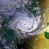
Cyclone Leon–Eline was a long-lived Indian Ocean tropical cyclone
which traversed almost the entire Indian ocean and made devastating strikes on Madagascar
, Mozambique
and South Africa
, and had less serious effects in Zimbabwe
where it eventually died out.
. The system was located about 325 nm from Christmas Island
, moving west-southwest and slowly gaining strength. The first warning by Joint Typhoon Warning Center
for Tropical Cyclone 11S was issued next day, and on same day it was named as Tropical Cyclone Leon by Perth TCWC. The cyclone continued its track to southwest whilst intensifying. It achieved hurricane strength on February 5, with estimated sustained winds of 80 mph and minimum central pressure of 960 mbar
. However by February 7 Leon had begun to weaken due to increasing wind shear
and it was downgraded to tropical storm. Leon was moving now fairly straightly towards west. It crossed 90°E longitude at February 8 and became Southwest Indian Ocean cyclone. As it had left Perth TCWC's area of responsibility, it was renamed as Eline by Mauritius Meteorological Service. It was located about 500 nm west-southwest from Cocos Islands, with sustained winds of 40 knots.
Over the next four days, Eline stayed at tropical storm strength with some fluctuations of intensity as it crossed the vast expanses of Indian Ocean. However by February 12 conditions had become more favourable for development and Eline began to gain strength again. On February 14 the system had turned course to west-southwest and regained cyclone strength with maximum sustained winds of about 70 knots. Satellite pictures revealed an eye of about 12 nm diameter. On February 14 Eline passed about 125 nm north of Mauritius and next day about 140 nm north of La Réunion
, dumping heavy rainfalls on those islands. It weakened briefly again but regained hurricane strength on February 16 and acquired more westerly track. The storm was now clearly threatening the east coast of Madagascar.
At this point, Eline underwent significant intensification. 1-minute average windspeed was estimated as at least 90 knots JTWC and RSMC La Réunion, but it may have been as high as 120 knots, equivalent to strong Category 3 hurricane. Cyclone Eline made landfall at Madagascar on February 17, about 30 nm north of Mahanoro. The storm weakened considerably over high, mountainous terrain of central Madagascar, but it retained its tropical characteristics, despite being downgraded to tropical depression by the time it emerged again at the western coast of the island on February 19. It began to slowly reintensify and regained tropical storm strength later that day. On 21st, it once again reached hurricane strength over Mozambique Channel
. At this point it was about 300 nm east-southeast of Beira
, moving slowly northeast. A well-defined 32 nm eye was apparent on satellite pictures at that time as system began yet another cycle of rapid intensification and storm reached its peak intensity. On morning of February 22, Intense Tropical Cyclone Eline made landfall about 40 nm south of Beira with estimated maximum sustained winds of 115 knots, or 135 mph, equivalent to a Category 4 cyclone. Eline began to weaken and was downgraded to category 2 by afternoon. Next day, Eline made landfall in Durban, KwaZulu Natal on the eastern coast of South Africa
, dropping a torrential amount of rain which flooded the eastern coast. By the next day, Eline was downgraded to tropical storm and moved north west to Zimbabwe
where it dissipated on February 23, 2000.
Cyclone Leon–Eline had been active over two and a half weeks, crossed almost the entire Indian Ocean during that time and made three destructive landfalls.
 Eline caused considerable destruction on Madagascar. Over 60,000 people were affected with at least 10,000 being left homeless. At least 64 people were listed as dead. Mahanoro was reported to have suffered 80% destruction. Effects were made worse by Moderate Tropical Storm Gloria which crossed the island in a similar fashion just a couple of weeks later.
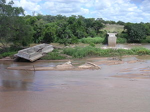
Damage to Mozambique was even worse, though difficult to estimate. When the storm struck, the country was already suffering from disastrous flooding and heavy rainfall, some of which were associated with earlier Cyclone Connie. At least 300,000 people were already displaced by this disaster when Eline struck in middle of it, seriously disrupting already stressed relief effort. For example, Eline sank four ships on Beira Harbour, delaying arrival of emergency food shipments. Up to 150 people were reported dead because of the storm, but total casualties from flooding, some of it caused by Eline, may have reached 1000. There was some limited damage to bridges and dams in Zimbabwe.
In South Africa, Cyclone Eline caused minimum damage to buildings in the city of Durban
, due to their strong structures , however, the force of the wind shattered windows, uprooted trees and blew vehicles and other objects around. The torrential rain also flooded the city and lighting struck several electricity towers, causing the city to face a major power outage for a week. Towns and other areas near the city were also effected by the cyclone and 200 people were killed in that part of South Africa.
Only a little over a month later, another intense long-lived storm, Very Intense Tropical Cyclone Hudah, brought additional destruction over northern Madagascar and the Mozambique coast, deepening the crisis even more.
Tropical cyclone
A tropical cyclone is a storm system characterized by a large low-pressure center and numerous thunderstorms that produce strong winds and heavy rain. Tropical cyclones strengthen when water evaporated from the ocean is released as the saturated air rises, resulting in condensation of water vapor...
which traversed almost the entire Indian ocean and made devastating strikes on Madagascar
Madagascar
The Republic of Madagascar is an island country located in the Indian Ocean off the southeastern coast of Africa...
, Mozambique
Mozambique
Mozambique, officially the Republic of Mozambique , is a country in southeastern Africa bordered by the Indian Ocean to the east, Tanzania to the north, Malawi and Zambia to the northwest, Zimbabwe to the west and Swaziland and South Africa to the southwest...
and South Africa
South Africa
The Republic of South Africa is a country in southern Africa. Located at the southern tip of Africa, it is divided into nine provinces, with of coastline on the Atlantic and Indian oceans...
, and had less serious effects in Zimbabwe
Zimbabwe
Zimbabwe is a landlocked country located in the southern part of the African continent, between the Zambezi and Limpopo rivers. It is bordered by South Africa to the south, Botswana to the southwest, Zambia and a tip of Namibia to the northwest and Mozambique to the east. Zimbabwe has three...
where it eventually died out.
Meteorological history
The storm was first identified as a tropical low south of Java at February 3 by Perth Tropical Cyclone Warning Center (PTCWC) at AustraliaAustralia
Australia , officially the Commonwealth of Australia, is a country in the Southern Hemisphere comprising the mainland of the Australian continent, the island of Tasmania, and numerous smaller islands in the Indian and Pacific Oceans. It is the world's sixth-largest country by total area...
. The system was located about 325 nm from Christmas Island
Christmas Island
The Territory of Christmas Island is a territory of Australia in the Indian Ocean. It is located northwest of the Western Australian city of Perth, south of the Indonesian capital, Jakarta, and ENE of the Cocos Islands....
, moving west-southwest and slowly gaining strength. The first warning by Joint Typhoon Warning Center
Joint Typhoon Warning Center
The Joint Typhoon Warning Center is a joint United States Navy – United States Air Force task force located at the Naval Maritime Forecast Center in Pearl Harbor, Hawaii...
for Tropical Cyclone 11S was issued next day, and on same day it was named as Tropical Cyclone Leon by Perth TCWC. The cyclone continued its track to southwest whilst intensifying. It achieved hurricane strength on February 5, with estimated sustained winds of 80 mph and minimum central pressure of 960 mbar
Bar (unit)
The bar is a unit of pressure equal to 100 kilopascals, and roughly equal to the atmospheric pressure on Earth at sea level. Other units derived from the bar are the megabar , kilobar , decibar , centibar , and millibar...
. However by February 7 Leon had begun to weaken due to increasing wind shear
Wind shear
Wind shear, sometimes referred to as windshear or wind gradient, is a difference in wind speed and direction over a relatively short distance in the atmosphere...
and it was downgraded to tropical storm. Leon was moving now fairly straightly towards west. It crossed 90°E longitude at February 8 and became Southwest Indian Ocean cyclone. As it had left Perth TCWC's area of responsibility, it was renamed as Eline by Mauritius Meteorological Service. It was located about 500 nm west-southwest from Cocos Islands, with sustained winds of 40 knots.
Over the next four days, Eline stayed at tropical storm strength with some fluctuations of intensity as it crossed the vast expanses of Indian Ocean. However by February 12 conditions had become more favourable for development and Eline began to gain strength again. On February 14 the system had turned course to west-southwest and regained cyclone strength with maximum sustained winds of about 70 knots. Satellite pictures revealed an eye of about 12 nm diameter. On February 14 Eline passed about 125 nm north of Mauritius and next day about 140 nm north of La Réunion
La Reunion
La Reunion may refer to:* La Reunion , a communal settlement near present-day Dallas, Texas*La Réunion, Lot-et-Garonne, a town in the Lot-et-Garonne department of France*Réunion, an island in the Indian Ocean east of Madagascar...
, dumping heavy rainfalls on those islands. It weakened briefly again but regained hurricane strength on February 16 and acquired more westerly track. The storm was now clearly threatening the east coast of Madagascar.
At this point, Eline underwent significant intensification. 1-minute average windspeed was estimated as at least 90 knots JTWC and RSMC La Réunion, but it may have been as high as 120 knots, equivalent to strong Category 3 hurricane. Cyclone Eline made landfall at Madagascar on February 17, about 30 nm north of Mahanoro. The storm weakened considerably over high, mountainous terrain of central Madagascar, but it retained its tropical characteristics, despite being downgraded to tropical depression by the time it emerged again at the western coast of the island on February 19. It began to slowly reintensify and regained tropical storm strength later that day. On 21st, it once again reached hurricane strength over Mozambique Channel
Mozambique Channel
The Mozambique Channel is a portion of the Indian Ocean located between the island nation of Madagascar and southeast Africa, primarily the country of Mozambique. It was a World War II clashpoint during the Battle of Madagascar...
. At this point it was about 300 nm east-southeast of Beira
Beira, Mozambique
Beira is the second largest city in Mozambique. It lies in the central region of the country in Sofala Province, where the Pungue River meets the Indian Ocean. Beira had a population of 412,588 in 1997, which grew to an estimated 546,000 in 2006...
, moving slowly northeast. A well-defined 32 nm eye was apparent on satellite pictures at that time as system began yet another cycle of rapid intensification and storm reached its peak intensity. On morning of February 22, Intense Tropical Cyclone Eline made landfall about 40 nm south of Beira with estimated maximum sustained winds of 115 knots, or 135 mph, equivalent to a Category 4 cyclone. Eline began to weaken and was downgraded to category 2 by afternoon. Next day, Eline made landfall in Durban, KwaZulu Natal on the eastern coast of South Africa
South Africa
The Republic of South Africa is a country in southern Africa. Located at the southern tip of Africa, it is divided into nine provinces, with of coastline on the Atlantic and Indian oceans...
, dropping a torrential amount of rain which flooded the eastern coast. By the next day, Eline was downgraded to tropical storm and moved north west to Zimbabwe
Zimbabwe
Zimbabwe is a landlocked country located in the southern part of the African continent, between the Zambezi and Limpopo rivers. It is bordered by South Africa to the south, Botswana to the southwest, Zambia and a tip of Namibia to the northwest and Mozambique to the east. Zimbabwe has three...
where it dissipated on February 23, 2000.
Cyclone Leon–Eline had been active over two and a half weeks, crossed almost the entire Indian Ocean during that time and made three destructive landfalls.
Impact
Damage to Mozambique was even worse, though difficult to estimate. When the storm struck, the country was already suffering from disastrous flooding and heavy rainfall, some of which were associated with earlier Cyclone Connie. At least 300,000 people were already displaced by this disaster when Eline struck in middle of it, seriously disrupting already stressed relief effort. For example, Eline sank four ships on Beira Harbour, delaying arrival of emergency food shipments. Up to 150 people were reported dead because of the storm, but total casualties from flooding, some of it caused by Eline, may have reached 1000. There was some limited damage to bridges and dams in Zimbabwe.
In South Africa, Cyclone Eline caused minimum damage to buildings in the city of Durban
Durban
Durban is the largest city in the South African province of KwaZulu-Natal and the third largest city in South Africa. It forms part of the eThekwini metropolitan municipality. Durban is famous for being the busiest port in South Africa. It is also seen as one of the major centres of tourism...
, due to their strong structures , however, the force of the wind shattered windows, uprooted trees and blew vehicles and other objects around. The torrential rain also flooded the city and lighting struck several electricity towers, causing the city to face a major power outage for a week. Towns and other areas near the city were also effected by the cyclone and 200 people were killed in that part of South Africa.
Only a little over a month later, another intense long-lived storm, Very Intense Tropical Cyclone Hudah, brought additional destruction over northern Madagascar and the Mozambique coast, deepening the crisis even more.
See also
- Cyclone GafiloCyclone GafiloCyclone Gafilo was a powerful tropical cyclone which struck Madagascar in March 2004, causing devastating damage. It is the most intense cyclone ever to form in the south-western Indian Ocean.-Meteorological history:...
- List of tropical cyclones
- 2000 Mozambique flood2000 Mozambique floodThe 2000 Mozambique flood was a natural disaster that occurred in February and March 2000. The catastrophic flooding was caused by heavy rainfall that lasted for five weeks and made many homeless. Approximately 800 people were killed. 1,400 km² of arable land was affected and 20,000 head of...
External links
- February 2000 tropical cyclone summary, by Australiasevereweather.com
- Leon-Eline Track
- http://www.weathersa.co.za/Pressroom/2000/2000FebTCEline.jsp
- http://www.geography.learnontheinternet.co.uk/topics/tropstormeline.html