

Cyclone Gafilo
Encyclopedia
Cyclone Gafilo was a powerful tropical cyclone
which struck Madagascar
in March 2004, causing devastating damage. It is the most intense cyclone ever to form in the south-western Indian Ocean
.
, south of Diego Garcia
. First advisories for Tropical Disturbance 09 were issued on March 2 by the Tropical Cyclone Warning Center on La Réunion
and Joint Typhoon Warning Center
. At this point, it was moving to west-northwest at fairly rapid pace. Development became quicker, and next day it was named Tropical Storm Gafilo. Its forward motion also slowed, and it began to turn southwards. On March 4, Gafilo was upgraded to tropical cyclone. Next day, March 5, Gafilo began a cycle of rapid deepening with winds increasing to 145 mph (230 km/h) making it a Category 4
cyclone. It was now moving west-southwest heading straight for Madagascar. The next day, March 6, 2004 saw it reach its estimated peak intensity of 895 hPa
and sustained windspeed of 160 mph (260 km/h). After midnight, Gafilo struck the northeast coast of Madagascar near to the town of Antalaha as a Category 5 cyclone, the highest possible rating.
After landfall, Gafilo continued its track to southwest, and emerged into the Mozambique Channel
still at Category 1 strength. The storm then weakened as it turned southeast and made a second landfall at southwest Madagascar as a strong tropical storm. Gafilo dissipated on March 11 over southern Madagascar, with remnant low emerging over the ocean, but hostile conditions prevented regeneration.
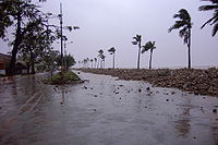 Striking Madagascar at peak intensity, Gafilo was the strongest cyclone to ever strike the country. Torrential rain and winds in excess of 300 km/h (185 mph) battered the region. Despite its extreme intensity, wind damage was mainly limited to areas in and around Antalaha
where 85% of homes were damaged or destroyed. The most significant impact resulted from fresh water flooding in northern and southwestern Madagascar. In all, 172 people were killed across the country and 879 more injured.
Offshore the northwestern port of Mahajanga
, a ferry named Le Samson (The Samson), carrying 113 people, capsized amidst rough seas produced by the storm. Of the crew and passengers, only two survived after creating a makeshift raft and drifting to shore.
Tropical cyclone
A tropical cyclone is a storm system characterized by a large low-pressure center and numerous thunderstorms that produce strong winds and heavy rain. Tropical cyclones strengthen when water evaporated from the ocean is released as the saturated air rises, resulting in condensation of water vapor...
which struck Madagascar
Madagascar
The Republic of Madagascar is an island country located in the Indian Ocean off the southeastern coast of Africa...
in March 2004, causing devastating damage. It is the most intense cyclone ever to form in the south-western Indian Ocean
Indian Ocean
The Indian Ocean is the third largest of the world's oceanic divisions, covering approximately 20% of the water on the Earth's surface. It is bounded on the north by the Indian Subcontinent and Arabian Peninsula ; on the west by eastern Africa; on the east by Indochina, the Sunda Islands, and...
.
Meteorological history
Gafilo began as a tropical disturbance on February 29, 2004 in the central Indian OceanIndian Ocean
The Indian Ocean is the third largest of the world's oceanic divisions, covering approximately 20% of the water on the Earth's surface. It is bounded on the north by the Indian Subcontinent and Arabian Peninsula ; on the west by eastern Africa; on the east by Indochina, the Sunda Islands, and...
, south of Diego Garcia
Diego Garcia
Diego Garcia is a tropical, footprint-shaped coral atoll located south of the equator in the central Indian Ocean at 7 degrees, 26 minutes south latitude. It is part of the British Indian Ocean Territory [BIOT] and is positioned at 72°23' east longitude....
. First advisories for Tropical Disturbance 09 were issued on March 2 by the Tropical Cyclone Warning Center on La Réunion
La Reunion
La Reunion may refer to:* La Reunion , a communal settlement near present-day Dallas, Texas*La Réunion, Lot-et-Garonne, a town in the Lot-et-Garonne department of France*Réunion, an island in the Indian Ocean east of Madagascar...
and Joint Typhoon Warning Center
Joint Typhoon Warning Center
The Joint Typhoon Warning Center is a joint United States Navy – United States Air Force task force located at the Naval Maritime Forecast Center in Pearl Harbor, Hawaii...
. At this point, it was moving to west-northwest at fairly rapid pace. Development became quicker, and next day it was named Tropical Storm Gafilo. Its forward motion also slowed, and it began to turn southwards. On March 4, Gafilo was upgraded to tropical cyclone. Next day, March 5, Gafilo began a cycle of rapid deepening with winds increasing to 145 mph (230 km/h) making it a Category 4
Saffir-Simpson Hurricane Scale
The Saffir–Simpson Hurricane Scale , or the Saffir–Simpson Hurricane Wind Scale , classifies hurricanes — Western Hemisphere tropical cyclones that exceed the intensities of tropical depressions and tropical storms — into five categories distinguished by the intensities of their sustained winds...
cyclone. It was now moving west-southwest heading straight for Madagascar. The next day, March 6, 2004 saw it reach its estimated peak intensity of 895 hPa
HPA
-Organizations:*Halifax Port Authority, a port authority in Canada*Hamburg Port Authority, the port authority for the Port of Hamburg, Germany*Health Protection Agency, a health organization in the United Kingdom...
and sustained windspeed of 160 mph (260 km/h). After midnight, Gafilo struck the northeast coast of Madagascar near to the town of Antalaha as a Category 5 cyclone, the highest possible rating.
After landfall, Gafilo continued its track to southwest, and emerged into the Mozambique Channel
Mozambique Channel
The Mozambique Channel is a portion of the Indian Ocean located between the island nation of Madagascar and southeast Africa, primarily the country of Mozambique. It was a World War II clashpoint during the Battle of Madagascar...
still at Category 1 strength. The storm then weakened as it turned southeast and made a second landfall at southwest Madagascar as a strong tropical storm. Gafilo dissipated on March 11 over southern Madagascar, with remnant low emerging over the ocean, but hostile conditions prevented regeneration.
Impact
Antalaha
Antalaha is a commune in northern Madagascar. It belongs to the district of Antalaha, which is a part of Sava Region. According to 2001 census the population of Antalaha was 75,000....
where 85% of homes were damaged or destroyed. The most significant impact resulted from fresh water flooding in northern and southwestern Madagascar. In all, 172 people were killed across the country and 879 more injured.
Offshore the northwestern port of Mahajanga
Mahajanga
Mahajanga is a city and a district on the north-west coast of Madagascar.- City :The City of Mahajanga is the capital of the Boeny region. Population: 135,660 ....
, a ferry named Le Samson (The Samson), carrying 113 people, capsized amidst rough seas produced by the storm. Of the crew and passengers, only two survived after creating a makeshift raft and drifting to shore.
Aftermath
Following the passage of the storm, the Malagasy government passed Inter-ministerial Order 17939/2004 in September 2004, which cleared the way for export of new and existing stocks of rosewood as "salvage." This created anarchy in the national parks in the SAVA Region, with loggers extracting a large amounts of rosewood and ebony, grossly disproportionate to the amount of damage caused by the cyclone. During this time, Marojejy National Park reported that with the granting of export rights, logging in the park had resumed. It wasn't until 2006, with the passing of Inter-ministerial Order 16030/2006, that the export ban was reinstated, nearly two years after the storm, but not before the exporters lobbied the government for an extension "following the grievances expressed by operators" in October 2005, per Memorandum 923/05. Exports were also authorized following cyclones in 2006 and 2007, encouraging the stockpiling of large quantities of lumber in both legal depots and hidden caches around the ports of Vohémar and Antalaha.See also
- List of most intense tropical cyclones
- Geography of MadagascarGeography of MadagascarMadagascar is an island in the Indian Ocean off the eastern coast of southern Africa, east of Mozambique. It is the fourth largest island in the world. The highest point is Maromokotro, in the Tsaratanana Massif region in the north of the island, at . The capital Antananarivo is in the Hauts...
- Illegal logging in MadagascarIllegal logging in MadagascarIllegal logging has been a problem in Madagascar for decades and is perpetuated by extreme poverty and government corruption. Often taking the form of selective logging, the trade has been driven by high international demand for expensive, fine-grained lumber such as rosewood and ebony...