
Cyclone George
Encyclopedia
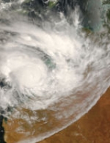
Severe Tropical Cyclone George (JTWC designation: 17S, also known as simply Cyclone George) was the third tropical cyclone
to affect the Australian region and the first to affect Western Australia
in 2007. The cyclone formed on 2 March in the Northern Territory
's Top End
late in February, and intensified when it entered the Joseph Bonaparte Gulf
, before crossing the northern coast of the Kimberley. It moved over the Indian Ocean
, intensifying to a Category 4 cyclone, and eventually crossed the Pilbara coast just east of Port Hedland
at peak intensity. It caused significant damage to the town of Port Hedland and numerous isolated mining camps around the town. Insured damage totalled A$8 million (US$6.2 million 2007), and there were 3 fatalities.
's Top End
since 27 February started showing signs of development, and the Tropical Cyclone Warning Centre in Darwin
initiated tropical cyclone advices on 2 March while the low was still inland. The Joint Typhoon Warning Center
issued a Tropical Cyclone Formation Alert
on the system later that day, and designated it Tropical Cyclone 17S the next day as it emerged into water.
Later on 3 March, TCWC Darwin upgraded the low to a tropical cyclone, naming it George, the first name used from the Darwin list since Fay in March 2004. George continued to strengthen, and was upgraded to a Category 2 tropical cyclone. It made landfall on 4 March in the Kimberley region Western Australia
on the western coast of the Joseph Bonaparte Gulf
. The tropical cyclone weakened and the BOM downgraded it to a tropical low after it moved over land, but this weakening was short lived however, as it almost immediately re-intensified into a Category 1 tropical cyclone when it started to move off the Kimberley coast.
The Tropical Cyclone Warning Centre in Perth
began monitoring the re-developed cyclone as it moved westward. Initially, poor organisation inhibited any strengthening, but George moved into more favourable conditions and quickly reorganised itself, becoming a severe tropical cyclone on 7 March. The severe cyclone turned abruptly to the south later that day, moving closer to the Pilbara coast, while growing significantly in size. As George continued to move southwards towards Port Hedland on 8 March, George was upgraded to a Category 4 cyclone, and a Category 5 just prior to landfall. At this time, the JTWC declared George to have intensified to 205 km/h (130 mph) 1-minute sustained winds, equivalent to a strong Category 3 in the Saffir-Simpson hurricane scale
.
Cyclone George made landfall just east of Port Hedland
at around Midnight. WDT
(1500 UTC) at 10pm a measurement was made of 195 km/h (125 mph) and a minimum pressure of 902 mbar (hPa; 26.64 inHg). A true measurement of the wind speed is unavailable as equipment failed at the Port Hedland Bureau of Meteorology an hour before the cyclone crossed the coast at midnight. George weakened slowly while over land and it was downgraded to a Category 3 late on 9 March. The next day TCWC in Perth
issued its final warning for the system.
Power and telephone lines were down in Port Hedland, many roofs and fences were torn down and trees were uprooted. At least one house was destroyed. The Pilbara region was declared a disaster zone
, and the Australian Defence Force
was on standby to provide extra help. George also caused the Port Hedland and Onslow radar's to be damaged as its course took it further to the southwest.
Tropical Cyclone Jacob struck almost the same area as George only three days later, although it was not as damaging or deadly as George. It did however cause some minor flooding.
Three people were killed and twenty-eight others were injured as a result of the severe cyclone. One death and the majority of the people injured occurred at a Fortescue Metals Group camp, about 100 km (62.13 mi) south of Port Hedland. Strong winds and flooding delayed the rescue efforts for most of the day. However, all injured workers were airlifted to the hospital in Port Hedland after the cyclone passed. The deaths occurred when strong winds knocked over temporary accommodation shelters known as donga
s. The second death occurred at Indee station, located between Port Hedland and the mining camp. The man died from severe internal injuries while escaping from his wrecked donga, trying to seek help at the main station homestead. A third death occurred when a man who was transferred to a Perth
hospital on 11 March died due to the injuries received when the cyclone hit at the Fortescue camp.
After Cyclone George struck the Pilbara coast, a relief fund was set up in order to help the victims of the storm. Mining companies, business, and residents all donated money to assist with the cause, and within 48 hours the town of Port Hedland was able to raise just over A$520,000 (US$410 in 2007; $ USD). BHP Billiton
also helped recover Port Hedland by giving the local government $1 million A$
each year which will fund for a large part of an enhancement scheme with the Western Australian State Government
to improve the town's appearance. Schools in South Hedland remained closed due to safety concerns about the damages caused by cyclones George and Jacob until 19 March, after the local community joined in a massive clean-up.
Tropical cyclone
A tropical cyclone is a storm system characterized by a large low-pressure center and numerous thunderstorms that produce strong winds and heavy rain. Tropical cyclones strengthen when water evaporated from the ocean is released as the saturated air rises, resulting in condensation of water vapor...
to affect the Australian region and the first to affect Western Australia
Western Australia
Western Australia is a state of Australia, occupying the entire western third of the Australian continent. It is bounded by the Indian Ocean to the north and west, the Great Australian Bight and Indian Ocean to the south, the Northern Territory to the north-east and South Australia to the south-east...
in 2007. The cyclone formed on 2 March in the Northern Territory
Northern Territory
The Northern Territory is a federal territory of Australia, occupying much of the centre of the mainland continent, as well as the central northern regions...
's Top End
Top End
The Top End of northern Australia is the second northernmost point on the continent. It covers a rather vaguely-defined area of perhaps 400,000 square kilometres behind the northern coast from the Northern Territory capital of Darwin across to Arnhem Land with the Indian Ocean on the west, the...
late in February, and intensified when it entered the Joseph Bonaparte Gulf
Joseph Bonaparte Gulf
Joseph Bonaparte Gulf is a large body of water off the coast of the Northern Territory, Australia and Western Australia. It was named after Joseph Bonaparte, brother of Napoleon and King of Naples and then Spain by French explorer and naturalist Nicholas Baudin in 1803...
, before crossing the northern coast of the Kimberley. It moved over the Indian Ocean
Indian Ocean
The Indian Ocean is the third largest of the world's oceanic divisions, covering approximately 20% of the water on the Earth's surface. It is bounded on the north by the Indian Subcontinent and Arabian Peninsula ; on the west by eastern Africa; on the east by Indochina, the Sunda Islands, and...
, intensifying to a Category 4 cyclone, and eventually crossed the Pilbara coast just east of Port Hedland
Port Hedland, Western Australia
Port Hedland is the highest tonnage port in Australia and largest town in the Pilbara region of Western Australia, with a population of approximately 14,000 ....
at peak intensity. It caused significant damage to the town of Port Hedland and numerous isolated mining camps around the town. Insured damage totalled A$8 million (US$6.2 million 2007), and there were 3 fatalities.
Meteorological history
A tropical low that had been centred over land in the Northern TerritoryNorthern Territory
The Northern Territory is a federal territory of Australia, occupying much of the centre of the mainland continent, as well as the central northern regions...
's Top End
Top End
The Top End of northern Australia is the second northernmost point on the continent. It covers a rather vaguely-defined area of perhaps 400,000 square kilometres behind the northern coast from the Northern Territory capital of Darwin across to Arnhem Land with the Indian Ocean on the west, the...
since 27 February started showing signs of development, and the Tropical Cyclone Warning Centre in Darwin
Darwin, Northern Territory
Darwin is the capital city of the Northern Territory, Australia. Situated on the Timor Sea, Darwin has a population of 127,500, making it by far the largest and most populated city in the sparsely populated Northern Territory, but the least populous of all Australia's capital cities...
initiated tropical cyclone advices on 2 March while the low was still inland. The Joint Typhoon Warning Center
Joint Typhoon Warning Center
The Joint Typhoon Warning Center is a joint United States Navy – United States Air Force task force located at the Naval Maritime Forecast Center in Pearl Harbor, Hawaii...
issued a Tropical Cyclone Formation Alert
Tropical Cyclone Formation Alert
A Tropical Cyclone Formation Alert is a bulletin released by the U.S. Navy-operated Joint Typhoon Warning Center in Honolulu, Hawaii or the Naval Maritime Forecast Center in Norfolk, Virginia, warning of the possibility of a tropical cyclone forming from a tropical disturbance that has been...
on the system later that day, and designated it Tropical Cyclone 17S the next day as it emerged into water.
Later on 3 March, TCWC Darwin upgraded the low to a tropical cyclone, naming it George, the first name used from the Darwin list since Fay in March 2004. George continued to strengthen, and was upgraded to a Category 2 tropical cyclone. It made landfall on 4 March in the Kimberley region Western Australia
Western Australia
Western Australia is a state of Australia, occupying the entire western third of the Australian continent. It is bounded by the Indian Ocean to the north and west, the Great Australian Bight and Indian Ocean to the south, the Northern Territory to the north-east and South Australia to the south-east...
on the western coast of the Joseph Bonaparte Gulf
Joseph Bonaparte Gulf
Joseph Bonaparte Gulf is a large body of water off the coast of the Northern Territory, Australia and Western Australia. It was named after Joseph Bonaparte, brother of Napoleon and King of Naples and then Spain by French explorer and naturalist Nicholas Baudin in 1803...
. The tropical cyclone weakened and the BOM downgraded it to a tropical low after it moved over land, but this weakening was short lived however, as it almost immediately re-intensified into a Category 1 tropical cyclone when it started to move off the Kimberley coast.
The Tropical Cyclone Warning Centre in Perth
Perth, Western Australia
Perth is the capital and largest city of the Australian state of Western Australia and the fourth most populous city in Australia. The Perth metropolitan area has an estimated population of almost 1,700,000....
began monitoring the re-developed cyclone as it moved westward. Initially, poor organisation inhibited any strengthening, but George moved into more favourable conditions and quickly reorganised itself, becoming a severe tropical cyclone on 7 March. The severe cyclone turned abruptly to the south later that day, moving closer to the Pilbara coast, while growing significantly in size. As George continued to move southwards towards Port Hedland on 8 March, George was upgraded to a Category 4 cyclone, and a Category 5 just prior to landfall. At this time, the JTWC declared George to have intensified to 205 km/h (130 mph) 1-minute sustained winds, equivalent to a strong Category 3 in the Saffir-Simpson hurricane scale
Saffir-Simpson Hurricane Scale
The Saffir–Simpson Hurricane Scale , or the Saffir–Simpson Hurricane Wind Scale , classifies hurricanes — Western Hemisphere tropical cyclones that exceed the intensities of tropical depressions and tropical storms — into five categories distinguished by the intensities of their sustained winds...
.
Cyclone George made landfall just east of Port Hedland
Port Hedland, Western Australia
Port Hedland is the highest tonnage port in Australia and largest town in the Pilbara region of Western Australia, with a population of approximately 14,000 ....
at around Midnight. WDT
Time in Australia
Australia uses Standard time, i.e: the same well defined time for a region. The proper names of Australia's time zones are Australian Western Standard Time , Australian Central Standard Time , and Australian Eastern Standard Time...
(1500 UTC) at 10pm a measurement was made of 195 km/h (125 mph) and a minimum pressure of 902 mbar (hPa; 26.64 inHg). A true measurement of the wind speed is unavailable as equipment failed at the Port Hedland Bureau of Meteorology an hour before the cyclone crossed the coast at midnight. George weakened slowly while over land and it was downgraded to a Category 3 late on 9 March. The next day TCWC in Perth
Perth, Western Australia
Perth is the capital and largest city of the Australian state of Western Australia and the fourth most populous city in Australia. The Perth metropolitan area has an estimated population of almost 1,700,000....
issued its final warning for the system.
Preparations
Cyclone George resulted in numerous schools and ports in Port Hedland being closed down in order to deal with the severe cyclone. Mining, Oil and Gas companies had to ultimately close in order to also deal with the threat of the imminent Cyclone. People were additionally evacuated from low lying levels near the sea, and moved either to higher ground, or further inland to Cyclone Shelters.Impact
Cyclone George was the most powerful cyclone to hit Port Hedland since Cyclone Joan in 1975. Peaking at 902 mbar (hPa; 26.64 inHg) with gusts up to 285 km/h (180 mph). Cyclone Joan is another unknown quantity, as The Port Hedland Bureau of Meteorology equipment failed during this cyclone too.Power and telephone lines were down in Port Hedland, many roofs and fences were torn down and trees were uprooted. At least one house was destroyed. The Pilbara region was declared a disaster zone
Disaster area
A disaster area is a region or a locale heavily damaged by either natural hazards, such as tornadoes, hurricanes, tsunamis, floods, earthquakes, technological hazards including nuclear and radiation accidents, or sociological hazards like riots, terrorism or war. The population living there often...
, and the Australian Defence Force
Australian Defence Force
The Australian Defence Force is the military organisation responsible for the defence of Australia. It consists of the Royal Australian Navy , Australian Army, Royal Australian Air Force and a number of 'tri-service' units...
was on standby to provide extra help. George also caused the Port Hedland and Onslow radar's to be damaged as its course took it further to the southwest.
Tropical Cyclone Jacob struck almost the same area as George only three days later, although it was not as damaging or deadly as George. It did however cause some minor flooding.
Three people were killed and twenty-eight others were injured as a result of the severe cyclone. One death and the majority of the people injured occurred at a Fortescue Metals Group camp, about 100 km (62.13 mi) south of Port Hedland. Strong winds and flooding delayed the rescue efforts for most of the day. However, all injured workers were airlifted to the hospital in Port Hedland after the cyclone passed. The deaths occurred when strong winds knocked over temporary accommodation shelters known as donga
Donga
-Places in Africa:*Donga River, Nigeria and Cameroon*Donga Department, in Benin*Donga, Angola, a town*Donga, Nigeria, a town and Local Government Area in Taraba State-Persons:, Ernesto dos Santos, the first recorder of Brazilian samba...
s. The second death occurred at Indee station, located between Port Hedland and the mining camp. The man died from severe internal injuries while escaping from his wrecked donga, trying to seek help at the main station homestead. A third death occurred when a man who was transferred to a Perth
Perth, Western Australia
Perth is the capital and largest city of the Australian state of Western Australia and the fourth most populous city in Australia. The Perth metropolitan area has an estimated population of almost 1,700,000....
hospital on 11 March died due to the injuries received when the cyclone hit at the Fortescue camp.
Aftermath
The Australian Workers Union (AWU) launched a scathing attack on the Fortescue Metals Group Ltd, saying they were disgraced that no evacuation took place before the cyclone hit. The AWU were also concerned about the buildings at the campsite as they were only built to withstand a Category 3 cyclone. Almost all of the buildings located at the camp site were destroyed.After Cyclone George struck the Pilbara coast, a relief fund was set up in order to help the victims of the storm. Mining companies, business, and residents all donated money to assist with the cause, and within 48 hours the town of Port Hedland was able to raise just over A$520,000 (US$410 in 2007; $ USD). BHP Billiton
BHP Billiton
BHP Billiton is a global mining, oil and gas company headquartered in Melbourne, Australia and with a major management office in London, United Kingdom...
also helped recover Port Hedland by giving the local government $1 million A$
Australian dollar
The Australian dollar is the currency of the Commonwealth of Australia, including Christmas Island, Cocos Islands, and Norfolk Island, as well as the independent Pacific Island states of Kiribati, Nauru and Tuvalu...
each year which will fund for a large part of an enhancement scheme with the Western Australian State Government
Government of Western Australia
The formation of the Government of Western Australia is prescribed in its Constitution, which dates from 1890, although it has been amended many times since then...
to improve the town's appearance. Schools in South Hedland remained closed due to safety concerns about the damages caused by cyclones George and Jacob until 19 March, after the local community joined in a massive clean-up.
See also
- List of cyclones in Western Australia
- Hurricane George (disambiguation)
- Hurricane Georges (disambiguation)Hurricane Georges (disambiguation)The name Hurricane Georges was available for use for tropical cyclones in the Atlantic Ocean every 6 years in the period 1980-1998. The convention is that the name is retired after a major hurricane.Prior to 1979, only female names were used...
External links
- TC George Pilbara Impact Report from the Bureau of Meteorology.