
Cumbria Coastal Way
Encyclopedia
The Cumbria Coastal Way (CCW) is a long distance footpath allowing users to travel from Cumbria's
southern border to just north of the English
- Scottish
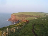
border. It follows some interesting scenery such as the red sandstone
cliffs of St. Bees Head
.
This footpath passes through the following locations (from South to North):
Cumbria
Cumbria , is a non-metropolitan county in North West England. The county and Cumbria County Council, its local authority, came into existence in 1974 after the passage of the Local Government Act 1972. Cumbria's largest settlement and county town is Carlisle. It consists of six districts, and in...
southern border to just north of the English
England
England is a country that is part of the United Kingdom. It shares land borders with Scotland to the north and Wales to the west; the Irish Sea is to the north west, the Celtic Sea to the south west, with the North Sea to the east and the English Channel to the south separating it from continental...
- Scottish
Scotland
Scotland is a country that is part of the United Kingdom. Occupying the northern third of the island of Great Britain, it shares a border with England to the south and is bounded by the North Sea to the east, the Atlantic Ocean to the north and west, and the North Channel and Irish Sea to the...
border. It follows some interesting scenery such as the red sandstone
Sandstone
Sandstone is a sedimentary rock composed mainly of sand-sized minerals or rock grains.Most sandstone is composed of quartz and/or feldspar because these are the most common minerals in the Earth's crust. Like sand, sandstone may be any colour, but the most common colours are tan, brown, yellow,...
cliffs of St. Bees Head
St. Bees Head
St Bees Head is a headland on the North West coast of the English county of Cumbria and is named after the nearby village of St Bees.It lies on the Cumbria Coastal Way and WainwrightCoast to Coast long-distance footpaths, it is the only stretch of Heritage Coast on the English coastline between the...
.
This footpath passes through the following locations (from South to North):
- Silverdale, LancashireSilverdale, LancashireSilverdale is a village and civil parish within the City of Lancaster in Lancashire, England. The village stands on Morecambe Bay, near the border with Cumbria, north west of Carnforth and north of Lancaster. The parish had a population of 1,545 recorded in the 2001 census.Silverdale forms part...
- 54.167°N 2.827°W - ArnsideArnsideArnside is a village and civil parish in Cumbria, England. It faces the estuary of the River Kent on the north eastern corner of Morecambe Bay, within the Arnside and Silverdale Area of Outstanding Natural Beauty...
- Grange-over-SandsGrange-over-SandsGrange-over-Sands is a town and civil parish by the sea – with a wide tidal range, hence the "sands" name – in Cumbria, England. Historically, Grange-over-Sands was part of the County of Lancashire until 1974, when Cumbria was created under Local Government re-organisation which absorbed the area...
- GreenoddGreenoddGreenodd is a village in the Furness area of the county of Cumbria but within the historical county of Lancashire. For local government purposes the village is also within the area of South Lakeland District. It is located 3 miles north-east of Ulverston at the junction of the A590 trunk road and...
- UlverstonUlverstonUlverston is a market town and civil parish in the South Lakeland district of Cumbria in north-west England. Historically part of Lancashire, the town is located in the Furness area, close to the Lake District, and just north of Morecambe Bay....
- Barrow-in-FurnessBarrow-in-FurnessBarrow-in-Furness is an industrial town and seaport which forms about half the territory of the wider Borough of Barrow-in-Furness in the county of Cumbria, England. It lies north of Liverpool, northwest of Manchester and southwest from the county town of Carlisle...
- Askam-in-FurnessAskam and IrelethDuring the Middle Ages, the entire area was controlled by the Cistercian monks of Furness Abbey. During this time, Ireleth was little more than one of many farming communities in Furness. The iron ore developments of Askam largely bypassed Ireleth, and the village developed slowly, housing farmers...
- Kirkby-in-FurnessKirkby-in-FurnessKirkby-in-Furness is a village in the Furness area of Cumbria, England. It is about 5 km south of Broughton in Furness and 8 km northwest of Ulverston. It is one of the largest villages on the peninsula's north-western coast, looking out over the Duddon estuary and the mountains of the...
- Broughton-in-FurnessBroughton-in-FurnessBroughton in Furness is a small town on the southern boundary of England's Lake District National Park. It is located in the Furness region of Cumbria, which was part of Lancashire before 1974...
- MillomMillomMillom is a town and civil parish on the estuary of the River Duddon in the southwest of Cumbria, England. The name is Cumbrian dialect for "At the mills". The town is accessible both by rail and an A class road...
- RavenglassRavenglassRavenglass is a small coastal village and natural harbour in Cumbria, England. It is the only coastal town within the Lake District National Park...
- SeascaleSeascaleSeascale is a village and civil parish on the Irish Sea coast of Cumbria in north-west England.-History:The place-name indicates that it was inhabited by Norse settlers, probably before 1000 AD. It is derived from skali, meaning in Norse a wooden hut or shelter...
- St. Bees
- St. Bees HeadSt. Bees HeadSt Bees Head is a headland on the North West coast of the English county of Cumbria and is named after the nearby village of St Bees.It lies on the Cumbria Coastal Way and WainwrightCoast to Coast long-distance footpaths, it is the only stretch of Heritage Coast on the English coastline between the...
- WhitehavenWhitehavenWhitehaven is a small town and port on the coast of Cumbria, England, which lies equidistant between the county's two largest settlements, Carlisle and Barrow-in-Furness, and is served by the Cumbrian Coast Line and the A595 road...
- WorkingtonWorkingtonWorkington is a town, civil parish and port on the west coast of Cumbria, England, at the mouth of the River Derwent. Lying within the Borough of Allerdale, Workington is southwest of Carlisle, west of Cockermouth, and southwest of Maryport...
- MaryportMaryportMaryport is a town and civil parish within the Allerdale borough of Cumbria, England, in the historic county of Cumberland. It is located on the A596 road north of Workington, and is the southernmost town on the Solway Firth. Maryport railway station is on the Cumbrian Coast Line. The town is in...
- AllonbyAllonbyAllonby is a village on the coast of the Allerdale district in Cumbria, England. The village is on the B5300 road five miles north of Maryport and eight miles south of Silloth....
- SillothSillothSilloth is a port town and civil parish in Cumbria, England. It sits on the shoreline of the Solway Firth, west of Carlisle. It has a population of 2,932....
- AbbeytownAbbeytownAbbeytown, also known as Holme Abbey, is a village in Cumbria, England. It was built around the former Cistercian Holmcultram Abbey, the nave of the church of which now serves the parish as St. Mary's Church...
- Burgh by SandsBurgh by SandsBurgh by Sands is a village and civil parish in the City of Carlisle district of Cumbria, England, situated near the Solway Firth. The parish includes the village of Burgh by Sands along with Longburgh, Dykesfield, Boustead Hill, Moorhouse and Thurstonfield....
- Carlisle - 54.895°N 2.934°W