

Cucurpe
Encyclopedia
Municipalities of Mexico
Municipalities are the second-level administrative division in Mexico . There are 2,438 municipalities in Mexico, making the average municipality population 45,616...
, and the town that serves as its municipal seat, of the same name in the Mexican state of Sonora
Sonora
Sonora officially Estado Libre y Soberano de Sonora is one of the 31 states which, with the Federal District, comprise the 32 Federal Entities of Mexico. It is divided into 72 municipalities; the capital city is Hermosillo....
.
History
Originally the territory was occupied by the Opatas and the Pimas AltasPima
The Pima are a group of American Indians living in an area consisting of what is now central and southern Arizona. The long name, "Akimel O'odham", means "river people". They are closely related to the Tohono O'odham and the Hia C-ed O'odham...
. In 1647 the Jesuit missionary
Missionary
A missionary is a member of a religious group sent into an area to do evangelism or ministries of service, such as education, literacy, social justice, health care and economic development. The word "mission" originates from 1598 when the Jesuits sent members abroad, derived from the Latin...
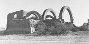
Marcos del Río founded the first Spanish settlement with the category of mission and gave it the name of "Los Santos Reyes de Cucurpe." In 1859 it was given the title of "Villa" and in 1932 it became a municipality.
This town was once the considered the "Rim of Christendom" and it was from here that Father Eusebio Kino
Eusebio Kino
Eusebio Francisco Kino S.J. was an Italian Roman Catholic priest who became famous in what is now northwestern Mexico and the southwestern United States in the region then known as the Pimaria Alta...
rode out to do his now historic work in the area then known as the Pimaria Alta. He rode out on 14 March 1687, 24 years and one day before his death on 15 March 1711.
Area and Population
The total area of the municipality is 1,778.55 square kilometers, which represents 0.96% of the state total and 0.09% of the national total. The population of the municipality was 937 inhabitants in the 2000 census and 798 inhabitants in the 2005 second count. The population of the municipal seat was 487 in 2000. The negative population growth is due to the high migration from this municipality, the deficient educational infrastructure, and the lack of sources of work.Municipal boundaries
The municipality has boundaries with ImurisÍmuris
Imuris is a municipality and a municipal seat in the north of the Mexican state of Sonora.-Area and Population:The municipal area is 1,710.3 km² with a population of 9,988 registered in 2000. Most of the inhabitants live in the municipal seat, which had a population of 5,767 in 2000...
in the north, Arizpe
Arizpe
Arizpe is a small town in Arizpe Municipality in the north of the Mexican state of Sonora. It is located at 30°20'"N 110°09'"W. The area of the municipality is 2,806.78 sq.km. The population in 2005 was 2,959 of which 1,743 lived in the municipal seat as of the 2000 census.-History and origin...
in the east, Opodepe
Opodepe
Opodepe is a municipality and a municipal seat in the north of the Mexican state of Sonora. The municipal area is 2,804.25 km² with a population of 2,842 registered in 2000. The main settlement and the municipal seat had a population of 346 in 2000...
in the south, Santa Ana
Santa Ana, Sonora
Santa Ana is a small city and municipal seat of the municipality of the same name in the Mexican state of Sonora. It is located 270 kilometers north of state capital Hermosillo and 100 kilometers south of Nogales on the United States border. The area of the municipality is 1,620.65 kms2 and the...
in the west, Magdalena de Kino
Magdalena de Kino
Magdalena de Kino is a city and surrounding municipality located in the Mexican state of Sonora covering approximately 560 square miles . According to the 2005 census, the city's population was 23,101, and the municipality's population was 25,500. Magdalena de Kino is in the northern section of...
in the northwest.
Rivers
There are two rivers that have clear waters for most of the year and turbulent currents in the rainy season that lasts from June to August. The Dolores River and the Saracachi come together to form the Sonora RiverSonora River
Río Sonora is a 402-kilometer-long river of Mexico. It lies on the Pacific slope of the Mexican state of Sonora and it runs into the Gulf of California.-Watershed:...
, which flows into the Abelardo L. Rodríguez Reservoir near Hermosillo
Hermosillo
Hermosillo is a city and municipality located centrally in the northwestern Mexican state of Sonora. It is the capital and main economic center for the state and region. It contains almost all of the state's manufacturing and has thirty percent of its population...
.
Climate
Due to the higher elevation the climate is cooler than in the desert to the west. The annual average temperature is 16.5°C, with summer temperatures rarely reaching 40º and winter days bringing frost and some snow in the higher elevations. The average annual rainfall is 466.8 millimeters.Economic activity
Most of the work force is employed in agriculture, which concentrates on growing grasses for cattle fodder. The cattle industry is modest and suffers from lack of infrastructure. There is one mine, Santa Gertrudis, which has offered a new source of employment.San Francisco mine
This former gold-silver-molybdenum mine, located about 3 km SE of Cucurpe, is famous among mineral collectors for producing exceptionally fine specimens of wulfeniteWulfenite
Wulfenite is a lead molybdate mineral with the formula PbMoO4. It can be most often found as thin tabular crystals with a bright orange-red to yellow-orange color, sometimes brown, although the color can be highly variable. In its yellow form it is sometimes called "yellow lead ore".It crystallizes...
.
External links
- Cucurpe, Ayuntamiento Digital (Official Website of Cucurpe, Sonora)
- Cucurpe @ Sonora Turismo (Spanish)
- Santa Gertrudis mine website