

Cuarenta Casas
Encyclopedia
 |
|
| Name: | Cuarenta Casas |
| Location | Casas Grandes, Chihuahua |
| Coordinates | 29°35′40.04"N 108°09′25.15"W |
| Culture | Paquimé, Cáhita Cáhita Cáhita is a group of Indigenous peoples of Mexico, which includes the Yaqui and Mayo people. Numbering approximately 40,000, they live in west coast of the states of Sonora and Sinaloa.-Language:... & Jovas |
| Period | Classical Mesoamerican |
| Foundation | Around 600 CE. (Paquimé Culture) |
| Decline | Late mesoamericano Classical, 1,340 d.C. |
| Language | Tarahumara Tarahumara language The Tarahumara language is a Mexican indigenous language of the Uto-Aztecan language family spoken by around 70,000 Tarahumara people in the state of Chihuahua, according to an estimate by the government of Mexico.-Genetic affiliation:Tarahumara belongs to the Taracahitic group of the Uto-Aztecan... - Rarámauri |
| INAH Official Page | Las Cuarenta Casas, Pagina Web INAH |
Cuarenta Casas is an archaeological site located in Vallecito, belongs to the Municipality of Casas Grandes
Casas Grandes
Casas Grandes is the contemporary name given to a pre-Columbian archaeological zone and its central site, located in northwestern Mexico in the modern-day Mexican state of Chihuahua. It is one of the largest and most complex sites in the region...
Chihuahua, it is 45 kilometers north of the Maderas Municipality, in the Sierra Madre Occidental
Sierra Madre Occidental
The Sierra Madre Occidental is a mountain range in western Mexico.-Setting:The range runs north to south, from just south of the Sonora–Arizona border southeast through eastern Sonora, western Chihuahua, Sinaloa, Durango, Zacatecas, Nayarit, Jalisco, Aguascalientes to Guanajuato, where it joins...
, Mexico
Mexico
The United Mexican States , commonly known as Mexico , is a federal constitutional republic in North America. It is bordered on the north by the United States; on the south and west by the Pacific Ocean; on the southeast by Guatemala, Belize, and the Caribbean Sea; and on the east by the Gulf of...
, some 250 kilometers northwest of Chihuahua City
Chihuahua, Chihuahua
The city of Chihuahua is the state capital of the Mexican state of Chihuahua. It has a population of about 825,327. The predominant activity is industry, including domestic heavy, light industries, consumer goods production, and to a smaller extent maquiladoras.-History:It has been said that the...
. The site consists of a series of cliff dwellings built in natural caves in the cliffs of Huapoca Canyon. The best known is the Cave of the Windows (Cueva de las Ventanas). Early Spanish explorers named the site Cuarenta Casas (forty houses) based on their speculation of the total number of structures. The area consists of five main cave communities: Cueva del Puente, Cueva de la Serpiente, Nido del Aguila and Cueva Grande.
The Zone
There are five Paquimé Culture archaeological sites in this area, accessible from the Madera municipality, as follows:Huápoca
Located 36 kilometers west of Madera, by a dirt road. The Anasazi caves consist of the Serpent and the Eagle Nest caves. They are considered the most impressive built on cliffs. Have complete structures.There are wonderful views of the Huapoca canyon.
Nido del águila
It only has one house, built on the edge of a sheer cliff under a rocky overhang, provides a meaning to its name.Cueva Grande
Located 66 kilometers west of Madera, on a dirt road. Cueva Grande hides within convoluted land and behind branches of trees. The mouth of the cave is obscured by a waterfall from the top of the cave to a stream.There are two, double-story houses (800 year old) that are good examples of the native construction techniques. There is also a round grain storage area behind the structure.
La Ranchería
Cave complex, 50 kilometers south of Madera. Has an extended archaeological remain area at the base of the Sirupa canyon.Cueva de Las Ventanas
During the ealy 16th century, explorer Alvar Núñez CabezaÁlvar Núñez Cabeza de Vaca
Álvar Núñez Cabeza de Vaca was a Spanish explorer of the New World, one of four survivors of the Narváez expedition...
wrote, "…and here by the side of the mountain, we forged our way inland more than 50 leagues and there found forty houses (cuarenta casas)…"
Site History
The current inhabitation of Chihuahua probably initiated throughout the Western Mountain Range (Sierra Madre Occidental), when native hunter-gatherer groups moved from the north looking for areas with abundant eatable plants. One of those groups produced the first known evidences in the "Cueva de las Ventanas", when they still lacked the constructions we now see. As these settlers dominated agricultural techniques, gradually began occupying the margins of the rivers and originated the Paquimé culture, neighboring what today is known as Casas Grandes, Chihuahua.Cuarentas Casas construction occurred during the height of Paquimé (Casas Grandes)
Casas Grandes
Casas Grandes is the contemporary name given to a pre-Columbian archaeological zone and its central site, located in northwestern Mexico in the modern-day Mexican state of Chihuahua. It is one of the largest and most complex sites in the region...
(1205-1260 CE), a period corresponding to the late Mogollon culture period. Cuarentas Casas was a refuge site, similar to others at the Mesa Verde
Mesa Verde National Park
Mesa Verde National Park is a U.S. National Park and UNESCO World Heritage Site located in Montezuma County, Colorado, United States. It was created in 1906 to protect some of the best-preserved cliff dwellings in the world...
and Bandalier
Bandelier National Monument
Bandelier National Monument is a National Monument preserving the homes of the Ancestral Pueblo People. It is named after Swiss anthropologist Adolph Bandelier, who researched the cultures of the area. Bandelier was designated a National Monument on February 11, 1916, and most of its backcountry...
sites. The buildings share the typical T-shaped doorways of their northern neighbors and are constructed from adobe
Adobe
Adobe is a natural building material made from sand, clay, water, and some kind of fibrous or organic material , which the builders shape into bricks using frames and dry in the sun. Adobe buildings are similar to cob and mudbrick buildings. Adobe structures are extremely durable, and account for...
and rock with pine logs beams.
It is possible that Cuarenta Casas was a garrison that protected allied groups in the region, in addition to safekeeping commercial routes. It settlers farmed maize and pumpkin, their nourishment was supplemented with hunting of small species (rabbits) and harvesting of eatable wild plants like acorns, yucca seeds and maguey leaves. This was confirmed by remains found in archaeological excavations. The Paquimé regional center must have had frequent problems with hostile neighboring groups, which explains the presence of many surveillance points in extensive areas. Besieged by those groups or perhaps by internal problems, the settlement decayed, was abandoned and some of its inhabitants emigrated.
Constructions date back to that period; at that time the zone was a meeting point for native traders of the Paquimé group communicating with the Pacific Ocean
Pacific Ocean
The Pacific Ocean is the largest of the Earth's oceanic divisions. It extends from the Arctic in the north to the Southern Ocean in the south, bounded by Asia and Australia in the west, and the Americas in the east.At 165.2 million square kilometres in area, this largest division of the World...
and Gulf of California
Gulf of California
The Gulf of California is a body of water that separates the Baja California Peninsula from the Mexican mainland...
coasts, and to other cultural centers to the north such as Mesa Verde in Colorado and Chaco Canyon in New Mexico. The routes to the Pacific followed the Piedras Verdes River to the south and connected with the rivers that flow to the Pacific by way of smaller arroyos and canyons. Among these is the Huapoca Canyon to the west of the town of Madera. The Huapoca Canyon is not among the deepest of the Sierra Tarahumara but it possesses the most archaeological interest.
The reasons why the settlement decayed, at 1340 CE are not known. At the Paquimé fall as social and cultural center, the commercial routes disappeared, the guardians left their posts and many settlements throughout the route were abandoned. Occasionally “Cueva de las Ventanas” was briefly occupied mainly with ceremonial purposes.
As of 1520, the caves still were inhabited by native groups, hence it was possible to obtain information about their way of life, the natives named themselves “Jovas” or Cáhita
Cáhita
Cáhita is a group of Indigenous peoples of Mexico, which includes the Yaqui and Mayo people. Numbering approximately 40,000, they live in west coast of the states of Sonora and Sinaloa.-Language:...
s, and with that name they also referred to a group or larger family. This ethnic group is now considered extinct.
The latest occupation of Cuarenta Casas occurred during the Paquimé apogee (1205 to 1260 CE); this period corresponds to the late period of Paquimé culture.
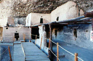
The Site
Of the cave complex, the only area partially restored is the “Cueva de las Ventanas”. It is a small archaeological site constructed with strong walls of poured adobe, with small “T” doors, characterizing the region pre-Hispanic architecture. It’s a two story structure of which only the ground floor rooms can be visited, these are distributed such that space was maximized within the space available in the cave.Room 2
On its higher section, a watchtower was constructed; it has a large number of small windows. It was equipped with a small drain channel and a urinal, the only ones found at the site. It is suspected it was used particularly during the crude winters of the region.Room 3
It is a large room, by its characteristics it must have been an area where most daily activities took place. Because of a sidewalk carved on the rock it is believed to have been used for certain ceremonies, as was done in the kivaKiva
A kiva is a room used by modern Puebloans for religious rituals, many of them associated with the kachina belief system. Among the modern Hopi and most other Pueblo peoples, kivas are square-walled and underground, and are used for spiritual ceremonies....
s, by southwestern US natives, from prehispanic times. This site has relevant similarities with sites of that region.
The room is partially roofed with pine beams and displays remains of windows that would perhaps complement those of the watchtower. Vestiges of a normal size door was found, all others are a meter of high. In this enclosure and almost in all other, the remains of strong floors with well finished stucco can be seen.
Room 4
It is almost totally destroyed, it lacks ceiling, and remaining walls indicate that its size was larger than others in the cave’s back, with similar functions to those of Room 3.Room 5
It’s lay out is irregular and it was built over a large rock. From old photographs of the site, it is known that its interior had an oval shaped barn, with a kind of woven grass cover. Its overall height was two meters, currently it is totally destroyed and it is only possible to see remains of the walls in the floor; these were reinforced with dry woven grass and covered with mud. Other similar barns have been found in like sites of the “Sierra Madre Occidental”.Room 6
The remaining rooms were built at the end of the cave, embedded in the rocky wall and it is believed were housing units.Number 6 is in the South side and still has its ceiling pine wood beams in good conditions. Being adjacent to rooms 3 and 7 it is very dark and cold.
Rooms 7 y 8
Number 7 is similar to the previous one, does not have any distinguishing characteristics. Number 8 lacks a ceiling and has access to a small area that perhaps was used as an internal patio. Perhaps it was used to manufacture arrows, as a required complementary activity. Several stone tools were found, of the type used to carve and smooth the wooden materials used to make projectiles.Rooms 9 y 10
Both are deteriorated and 10 were probably propped up by the last inhabitants. Vestiges of small stoves were found as well as compacted earth steps that lead to the long enclosures that are to the front.Room 11
Basically it is similar to the previous, but for some reason native groups of similar cultures to the constructors, visited it and painted zoomorphic designs on its walls; these are streamlined figures that represent elongated birds, the beak is apparent. It is possible that these artists were the original inhabitants, which returned to celebrate some type of ritual that could not be made elsewhere.Room 12
An individual burial was found, perhaps a local leader, it was placed in the small space between the wall and the rock of the cave. It had a small maize offering, one ceramic pot and a leather bag with pinolePinole (staple)
Pinole is a Spanish translation of an Aztec word for a coarse flour made from ground toasted maize kernels, often in a mixture with a variety of herbs and ground seeds, which can be eaten by itself or be used as the base for a beverage...
, used by pre-Hispanic people of Mexico. The burial also contained, semiprecious stones, possibly currency to ensure his entrance to the underworld. The man was shrouded in a mortuary bed roll (Petate
Petate
A petate is a bedroll used in Central America and México. Its name comes from the Náhuatl word petlatl. The petate is woven from the fibers of the Palm of petate . The Royal Spanish Academy defines it as a bed. Generally petates are woven in quadrangular forms, though not to any exact...
) similar those depicted in some of the pre-Hispanic codices.
Rooms 13 y 14
Number 13 is very deteriorated and perhaps had large dimensions.Number 14 is smaller and isolated, was constructed at the rocky bottom and because of its small dimensions it could only be used to sleep, as well as to temporarily isolate people, as per inhabitants beliefs, and as was done with young girls at the time of their first menstruation. This custom was practiced by native groups of the area, even in current times. .
From this room it is possible to see the floors of the second floor rooms, although deteriorated, clay molded forms can be seen near the center of each floor; these are of rectangular shape and not too high, perhaps stoves used in the site.
Further reading
- Schaafsma, Curtis F. and Riley, Carroll L. (1999) The Casas Grandes World University of Utah Press, Salt Lake City, Utah, ISBN 0-87480-595-3
- Guevara Sánchez, Arturo (1984) Las Cuarenta Casas: Un Sitio Arqueologico del Estado de Chihuahua Instituto Nacional de Antropologia e Historia, Departmento de Prehistoria Cuaderno de Trabajo No. 27, Mexico, D.F.
- Guevara Sánchez, Arturo (1985) Apuntes Para la Arqueologia de Chihuahua Instituto Nacional de Antropo1ogia e Historia, Departmento de Prehistoria Cuaderno de Trabajo, Centro Regional de Chihuahua No. 1, Mexico, D.F.
- Guevara Sánchez, Arturo (1986) Arqueología del área de las Cuarenta Casas, Chihuahua Instituto Nacional de Antropologia e Historia Colleccion Cientifica, Mexico, D.F., ISBN 968-6038-42-6
External links
- "Prehistoric Desert Peoples: The Mogollon" Desert USA
- Photographs of the ruins at "Cave Dwellings of the Huapoca Canyon, Mexico" Adventures Great and Small
- Photographs of the ruins at "Zona Arqueológica Cuarenta Casas" Foros, Univision Communications Inc.