

Cross Florida Barge Canal
Encyclopedia
Canal
Canals are man-made channels for water. There are two types of canal:#Waterways: navigable transportation canals used for carrying ships and boats shipping goods and conveying people, further subdivided into two kinds:...
project to connect the Gulf of Mexico
Gulf of Mexico
The Gulf of Mexico is a partially landlocked ocean basin largely surrounded by the North American continent and the island of Cuba. It is bounded on the northeast, north and northwest by the Gulf Coast of the United States, on the southwest and south by Mexico, and on the southeast by Cuba. In...
and the Atlantic Ocean
Atlantic Ocean
The Atlantic Ocean is the second-largest of the world's oceanic divisions. With a total area of about , it covers approximately 20% of the Earth's surface and about 26% of its water surface area...
across Florida
Florida
Florida is a state in the southeastern United States, located on the nation's Atlantic and Gulf coasts. It is bordered to the west by the Gulf of Mexico, to the north by Alabama and Georgia and to the east by the Atlantic Ocean. With a population of 18,801,310 as measured by the 2010 census, it...
for barge
Barge
A barge is a flat-bottomed boat, built mainly for river and canal transport of heavy goods. Some barges are not self-propelled and need to be towed by tugboats or pushed by towboats...
traffic. Two sections were built but the project was cancelled, mainly for environmental
Environmental movement
The environmental movement, a term that includes the conservation and green politics, is a diverse scientific, social, and political movement for addressing environmental issues....
reasons. It is now a protected green belt
Green belt
A green belt or greenbelt is a policy and land use designation used in land use planning to retain areas of largely undeveloped, wild, or agricultural land surrounding or neighbouring urban areas. Similar concepts are greenways or green wedges which have a linear character and may run through an...
corridor, one mile (1.6 km) wide in most places. Named after the leader in the opposition against the canal, Marjorie Harris Carr
Marjorie Harris Carr
Marjorie Harris Carr was an American conservationist.Born in Boston, Massachusetts, Harris moved to Lee County in southwest Florida. In 1936, she received a B.S. in zoology from Florida State College for Women; in 1942, she received an M.A. from the University of Florida...
, it is known as the Marjorie Harris Carr Cross Florida Greenway.
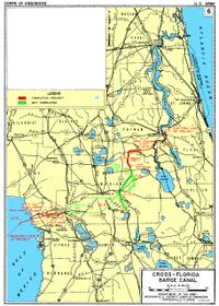
Route
The planned route of the canal followed the St. Johns RiverSt. Johns River
The St. Johns River is the longest river in the U.S. state of Florida and its most significant for commercial and recreational use. At long, it winds through or borders twelve counties, three of which are the state's largest. The drop in elevation from the headwaters to the mouth is less than ;...
from the Atlantic coast to Palatka
Palatka, Florida
Palatka is a city in Putnam County, Florida, United States. The population was 10,033 at the 2000 census. As of 2004, the population recorded by the U.S. Census Bureau is 10,796. It is the county seat of Putnam County and includes East Palatka. Palatka is the principal city of the Palatka...
, the valley of the Ocklawaha River
Ocklawaha River
The Ocklawaha River flows north from central Florida until it joins the St. Johns River near Palatka. Its name is a corruption of ak-lowahe, Creek for "muddy"....
to the coastal divide, and the Withlacoochee River
Withlacoochee River (South)
The Withlacoochee River originates in central Florida's Green Swamp, east of Polk City. It flows west, then north, and then turns northwest and finally west again before it empties into the Gulf of Mexico near Yankeetown. The river is long and has a drainage basin of...
to the Gulf of Mexico
Gulf of Mexico
The Gulf of Mexico is a partially landlocked ocean basin largely surrounded by the North American continent and the island of Cuba. It is bounded on the northeast, north and northwest by the Gulf Coast of the United States, on the southwest and south by Mexico, and on the southeast by Cuba. In...
. About 28% of the 107-mile (172 km) project was built—the cross-country section 29°32′15"N 81°44′48"W from the St. Johns River
St. Johns River
The St. Johns River is the longest river in the U.S. state of Florida and its most significant for commercial and recreational use. At long, it winds through or borders twelve counties, three of which are the state's largest. The drop in elevation from the headwaters to the mouth is less than ;...
to the Oklawaha River, part of the route along the Oklawaha, and a small section 29°00′46"N 82°39′54"W at the Gulf of Mexico
Gulf of Mexico
The Gulf of Mexico is a partially landlocked ocean basin largely surrounded by the North American continent and the island of Cuba. It is bounded on the northeast, north and northwest by the Gulf Coast of the United States, on the southwest and south by Mexico, and on the southeast by Cuba. In...
end up to the dammed Lake Rousseau
Lake Rousseau
Lake Rousseau is a reservoir on the Withlacoochee River in central Florida, USA, on the boundary of Levy County to the north-west, Marion County to the north-east, and Citrus County to the south. It was created in the 1920s when the river was dammed....
.
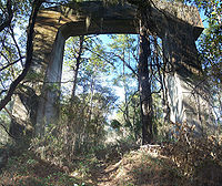
Bridges and other infrastructure
All the bridges over the St. Johns RiverSt. Johns River
The St. Johns River is the longest river in the U.S. state of Florida and its most significant for commercial and recreational use. At long, it winds through or borders twelve counties, three of which are the state's largest. The drop in elevation from the headwaters to the mouth is less than ;...
north of the canal are high enough for ships, or have movable sections. High bridges were built over the canal, as well as several over the Ocklawaha River
Ocklawaha River
The Ocklawaha River flows north from central Florida until it joins the St. Johns River near Palatka. Its name is a corruption of ak-lowahe, Creek for "muddy"....
where it was not widened to the canal. The following major roads, railroads, and locks
Lock (water transport)
A lock is a device for raising and lowering boats between stretches of water of different levels on river and canal waterways. The distinguishing feature of a lock is a fixed chamber in which the water level can be varied; whereas in a caisson lock, a boat lift, or on a canal inclined plane, it is...
and dam
Dam
A dam is a barrier that impounds water or underground streams. Dams generally serve the primary purpose of retaining water, while other structures such as floodgates or levees are used to manage or prevent water flow into specific land regions. Hydropower and pumped-storage hydroelectricity are...
s cross the path of the canal:
- Buckman Lock (formerly St. Johns Lock)
- SR 19Florida State Road 19State Road 19 is a Florida State Road in Putnam, Marion, and Lake counties. It runs from Groveland to Palatka. It provides access to areas in Ocala National Forest, like Pittman.-Groveland to Tavares:...
(high bridge) - Rodman Dam (south of the canal on the Ocklawaha RiverOcklawaha RiverThe Ocklawaha River flows north from central Florida until it joins the St. Johns River near Palatka. Its name is a corruption of ak-lowahe, Creek for "muddy"....
, forming Lake Ocklawaha along the canal) - Eureka Dam (unfinished)
- CR 316 (high bridge)
- SR 40, Bert Dosh Memorial BridgeBert Dosh Memorial BridgeThe Bert Dosh Memorial Bridge carries State Road 40 over the Ocklawaha River in north-central Florida, east of Silver Springs.Originally planned as part of the Cross Florida Barge Canal project, the bridge was under construction at the time of the decision by President Richard Nixon to halt work on...
(high bridge) - CR 314 (no bridge)
- SR 35Florida State Road 35State Road 35 is a north–south state highway in the western counties of the U.S. state of Florida.-Route Description:It is mainly signed as a hidden route along U.S. Highways:*U.S. Route 17: Punta Gorda to Bartow....
(no bridge) - SR 464 (no bridge)
- Florida Northern RailroadFlorida Northern Railroad (current)The Florida Northern Railroad is one of several short line railroads run by the Pinsly Railroad Company. It has connections to CSX at Ocala, Florida, running north to Lowell, Florida and south to Candler, Florida...
(no bridge) - CSX S-Line (no bridge)
- US 27-301U.S. Route 301 in FloridaU.S. Route 301 in Florida runs from the Sarasota-Bradenton-Venice, Florida Metropolitan Statistical Area northeast to the Greater Jacksonville Metropolitan Area. The road is a spur of U.S...
-441 (SR 25Florida State Road 25State Road 25 is a state highway in the U.S. state of Florida.It is mainly signed as U.S. Highways:*U.S. Highway 27 from Miami to Lady Lake and Belleview to Ocala*U.S. Highway 301 from Belleview to near Sparr...
/SR 500Florida State Road 500State Road 500 is a major state highway running through Florida as a mostly unsigned route under several US Highways. From Chiefland to Williston it is U.S. Highway 27 Alternate. From Williston to Ocala, it is U.S. Highway 27. From Ocala to Kissimmee, it is U.S. Highway 441. From Kissimmee to...
) (no bridge, but several unused supports in the median) - CR 475 (no bridge)
- I-75 (SR 93) (no bridge; recently built land bridgeLand bridgeA land bridge, in biogeography, is an isthmus or wider land connection between otherwise separate areas, over which animals and plants are able to cross and colonise new lands...
over I-75 for trail users) - SW 49th Avenue (no bridge; recently built underpass for trail users)
- CR 484 (no bridge)
- SR 200 (no bridge)
- CSX line (low bridge over the existing Withlacoochee River)
- US 41 (SR 45), Brittan Alexander Bridge (low bridge over the existing Withlacoochee River)
- Inglis Lock (Inglis Dam is south of the canal on the Withlacoochee River, forming Lake RousseauLake RousseauLake Rousseau is a reservoir on the Withlacoochee River in central Florida, USA, on the boundary of Levy County to the north-west, Marion County to the north-east, and Citrus County to the south. It was created in the 1920s when the river was dammed....
along the canal) - US 19-98 (SR 55Florida State Road 55State Road 55 is mainly the internal or secret designation of U.S. Route 19 through Florida, although it has appeared on maps and atlases in several occasions. State Road 55 originates at the Georgia border north of Ashville, and ends at SR 684 in Bradenton. North of Perry, it's the secret route...
) (high bridge, duplicate currently under construction)
Between Lake Rousseau and the Ocklawaha River, discontinuous, unwatered excavations mark the canal's planned path, along with different vegetation patterns on the land acquired for the project (as seen from the air).
History
The idea of such a canal was first proposed by Philip II of SpainPhilip II of Spain
Philip II was King of Spain, Portugal, Naples, Sicily, and, while married to Mary I, King of England and Ireland. He was lord of the Seventeen Provinces from 1556 until 1581, holding various titles for the individual territories such as duke or count....
in 1567. It was repeatedly considered over the years but found to be economically unviable. Secretary of War
United States Secretary of War
The Secretary of War was a member of the United States President's Cabinet, beginning with George Washington's administration. A similar position, called either "Secretary at War" or "Secretary of War," was appointed to serve the Congress of the Confederation under the Articles of Confederation...
John C. Calhoun
John C. Calhoun
John Caldwell Calhoun was a leading politician and political theorist from South Carolina during the first half of the 19th century. Calhoun eloquently spoke out on every issue of his day, but often changed positions. Calhoun began his political career as a nationalist, modernizer, and proponent...
once again proposed a canal in 1818 in order to solve the losses due to shipwrecks and piracy. The Florida Railroad
Florida Railroad
The Florida Railroad was the first railroad to connect the east and west coasts of Florida, running from Fernandina to Cedar Key. The line later became part of the Seaboard Air Line Railroad, and, where still in use, is operated by CSX Transportation and the First Coast Railroad...
, finished on March 1, 1861, served a similar purpose, connecting the Atlantic Ocean
Atlantic Ocean
The Atlantic Ocean is the second-largest of the world's oceanic divisions. With a total area of about , it covers approximately 20% of the Earth's surface and about 26% of its water surface area...
at Fernandina
Fernandina Beach, Florida
Fernandina Beach is a city in Nassau County in the state of Florida in the United States of America and on Amelia Island. It is a part of Greater Jacksonville and is among Florida's northernmost cities. The area was first inhabited by the Timucuan Indian tribe...
to the Gulf of Mexico
Gulf of Mexico
The Gulf of Mexico is a partially landlocked ocean basin largely surrounded by the North American continent and the island of Cuba. It is bounded on the northeast, north and northwest by the Gulf Coast of the United States, on the southwest and south by Mexico, and on the southeast by Cuba. In...
at Cedar Key
Cedar Key, Florida
Cedar Key is a city in Levy County, Florida, United States. The population was 790 at the 2000 census. According to the U.S Census estimates of 2005, the city had a population of 958. The Cedar Keys are a cluster of islands close to the mainland. Most of the developed area of the city has been on...
.
In the 1930s, regional politicians lobbied the federal government to fund canal construction as an economic recovery program, and president Franklin D. Roosevelt
Franklin D. Roosevelt
Franklin Delano Roosevelt , also known by his initials, FDR, was the 32nd President of the United States and a central figure in world events during the mid-20th century, leading the United States during a time of worldwide economic crisis and world war...
allocated emergency funds in 1935. Local opponents of the canal protested that the canal would deplete Florida's aquifer
Aquifer
An aquifer is a wet underground layer of water-bearing permeable rock or unconsolidated materials from which groundwater can be usefully extracted using a water well. The study of water flow in aquifers and the characterization of aquifers is called hydrogeology...
s, and work was stopped a year later.
Work was reauthorized in 1942 as a national defense project, with dam
Dam
A dam is a barrier that impounds water or underground streams. Dams generally serve the primary purpose of retaining water, while other structures such as floodgates or levees are used to manage or prevent water flow into specific land regions. Hydropower and pumped-storage hydroelectricity are...
s and locks to protect the underground water supply. Support for the project from Washington was sporadic, and funds were never allocated to USACE to actually start construction.
Planning was once again given the go-ahead in 1963 with support from president John F. Kennedy
John F. Kennedy
John Fitzgerald "Jack" Kennedy , often referred to by his initials JFK, was the 35th President of the United States, serving from 1961 until his assassination in 1963....
, who allocated one million dollars to the project. The next year, Lyndon Johnson set off the explosives that started construction. It was hoped that the canal, along with the St. Johns-Indian River Barge Canal
St. Johns-Indian River Barge Canal
The St. Johns-Indian River Barge Canal was a planned canal in the state of Florida, in length and linking the Intracoastal Waterway and the Indian River south of Oak Hill with the St. Johns River, originally intended to be just south of Lake Harney, but later shifted to be near Lake Monroe, with...
, would provide a quicker and safer route across Florida by 1971.
Opponents subsequently campaigned against the canal on environmental grounds, and the project stopped again in January 1971. It was officially cancelled in 1991. The right-of-way
Easement
An easement is a certain right to use the real property of another without possessing it.Easements are helpful for providing pathways across two or more pieces of property or allowing an individual to fish in a privately owned pond...
was turned over to the state and became the Marjorie Harris Carr Cross Florida Greenway, named in honor of the woman who led opposition to the canal.
Project timeline
- May 1933 - Canal Authority of the State of Florida was created to construct and maintain a deep-water ship canal across Florida.
- 1935-1936 – Construction of a ship canal began under the Emergency Relief Appropriations Act of 1935, but work was suspended when Federal funds were depleted.
- July 1942 – Congress authorized construction of the Cross Florida Barge Canal.
- February 1964 – The U. S. Army Corps of Engineers began construction of the Cross Florida Barge Canal.
- 1969 – The Environmental Defense Fund and others filed suit in the U. S. District Court for the District of Columbia seeking temporary and permanent injunction against the construction of the canal.
- January 15, 1971 – The District Court granted a preliminary injunction halting any further construction activities pending the outcome of the litigation.
- January 19, 1971 – President Richard Nixon signed an executive order suspending further work on the Barge Canal. When halted, the project was one-third complete and approximately $74 million had been spent on land acquisition and construction.
- 1979 – Bills filed in Congress to deauthorize the Canal failed to pass.
- May 22, 1990 - A revised federal bill was filed in the U. S. Senate by Senators Bob Graham and Connie Mack providing, among other things, for a minimum 300-yard wide greenway corridor to be maintained along the former Barge Canal route. This bill was agreed to by the entire Florida Congressional delegation.
- May 31, 1990 - The Florida Legislature enacted a deauthorization bill conforming to the consensus bill filed in the U. S. Senate. Most of the provisions were not effective until Congress deauthorized the project.
- October 27, 1990 – Senate Bill 2740 was passed by Congress and sent to the President for signature. The bill deauthorized the Cross Florida Barge Canal project upon acceptance by the Governor and Cabinet of the State of Florida.
- November 28, 1990 – President George Bush signed SB 2740 into law deauthorizing the Cross Florida Barge Canal project and changing the purpose of the lands to recreation and conservation.
- January 22, 1991 – The Governor and Cabinet of the State of Florida signed a resolution agreeing to the terms of the Federal deauthorization bill thereby officially deauthorizing the Cross Florida Barge Canal project. This action ultimately led to the creation of the Cross Florida Greenway State Recreation and Conservation Area.
- 1998 - The Cross Florida Greenway was officially renamed the Marjorie Harris Carr Cross Florida Greenway in honor of the individual who led the fight to stop the Cross Florida Barge Canal project.
External links
- Florida DEP - Marjorie Harris Carr Cross Florida Greenway
- US Army Corps of Engineers - Cross-Florida Barge Canal - 1996 Condition of Improvement
- US Army Corps of Engineers - Cross-Florida Barge Canal {Wayback Machine - Archived Page}
- US Army Corps of Engineers - Henry H. Buckman Lock {Wayback Machine - Archived Page}
- US Army Corps of Engineers - Atlantic-Gulf Ship Canal (Wayback Machine - Archived Page}