
Coyote Gulch
Encyclopedia

Escalante River
right|Location of the Escalante River within UtahThe Escalante River is a tributary of the Colorado River. It is formed by the confluence of North and Birch Creeks near the town of Escalante in south-central Utah, and from there flows southeast for approximately before joining Lake Powell...
, located in Garfield
Garfield County, Utah
Garfield County is a county located in the U.S. state of Utah. As of 2000 the population was 4,735. It was named for James A. Garfield, President of the United States in 1881. Its county seat and largest city is Panguitch.-Geography:...
and Kane
Kane County, Utah
As of the census of 2000, there were 6,046 people, 2,237 households, and 1,628 families residing in the county. The population density was 2 people per square mile . There were 3,767 housing units at an average density of 1 per square mile...
Counties in southern Utah
Utah
Utah is a state in the Western United States. It was the 45th state to join the Union, on January 4, 1896. Approximately 80% of Utah's 2,763,885 people live along the Wasatch Front, centering on Salt Lake City. This leaves vast expanses of the state nearly uninhabited, making the population the...
, in the western United States
United States
The United States of America is a federal constitutional republic comprising fifty states and a federal district...
. Over 25 miles (40 km) long, it exhibits many of the geologic features found in the Canyons of the Escalante
Canyons of the Escalante
The Canyons of the Escalante is a collective name for the erosional landforms created by the Escalante River and its tributaries, the Escalante River Basin. Located in southern Utah in the western United States, these sandstone features include high vertical canyon walls, water pockets, narrow...
, including high vertical canyon walls, narrow slot canyons, domes, arches, and natural bridges. A popular recreational destination, it is located within both the Grand Staircase-Escalante National Monument
Grand Staircase-Escalante National Monument
The Grand Staircase-Escalante National Monument contains 1.9 million acres of land in southern Utah, the United States. There are three main regions: the Grand Staircase, the Kaiparowits Plateau, and the Canyons of the Escalante. President Bill Clinton designated the area as a U.S. National...
(upper sections) and the Glen Canyon National Recreation Area
Glen Canyon National Recreation Area
Glen Canyon National Recreation Area is a recreation and conservation unit of the National Park Service that encompasses the area around Lake Powell and lower Cataract Canyon in Utah and Arizona, covering 1,254,429 acres of mostly desert...
(lower sections).
The headwaters of Coyote Gulch have their origins along a 14 mile (22 km) segment of the Straight Cliffs, the eastern edge of the Kaiparowits Plateau
Kaiparowits Plateau
right|Location of the Kaiparowits Plateau within UtahThe Kaiparowits Plateau is a large, elevated landform located in southern Utah, in the southwestern United States. Along with the Grand Staircase and the Canyons of the Escalante, it makes up a significant portion of the Grand...
. These intermittent streams merge to form larger branches, including Dry Fork, Big Hollow, the main branch of Coyote Gulch, and Hurricane Wash. The combined flow from these branches have carved a canyon
Canyon
A canyon or gorge is a deep ravine between cliffs often carved from the landscape by a river. Rivers have a natural tendency to reach a baseline elevation, which is the same elevation as the body of water it will eventually drain into. This forms a canyon. Most canyons were formed by a process of...
up to 900 feet (300 m) deep into sandstone layers, before meeting the main channel of the Escalante River.
The northernmost branch, Dry Fork, is one of the most popular destinations in the area. A short side road leads off from the Hole-in-the-Rock Road
Hole in the Rock Road
The Hole in the Rock Trail is a historic road running west of the Escalante River in southern Utah in the western United States. Running almost from near Escalante to Bluff, it travels within the borders of the Grand Staircase-Escalante National Monument and the adjacent Glen Canyon National...
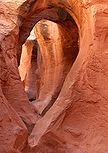
to a trailhead above the wash. A brief descent then leads to four areas of interest. The Dry Fork Narrows is an excellent example of how occasional flash floods have carved a narrow slot
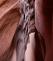
Slot canyon
A slot canyon is a narrow canyon, formed by the wear of water rushing through rock. A slot canyon is significantly deeper than it is wide. Some slot canyons can measure less than one metre across at the top but drop more than 30 m to the floor of the canyon.Most slot canyons are formed in...
into the underlying Navajo Sandstone
Navajo Sandstone
Navajo Sandstone is a geologic formation in the Glen Canyon Group that is spread across the U.S. states of northern Arizona, northwest Colorado, and Utah; as part of the Colorado Plateau province of the United States...
. Approximately 20 feet (7 m) deep, the slot can be followed upstream for several hundred yards. Further upsteam from this area is a large sandstone
Sandstone
Sandstone is a sedimentary rock composed mainly of sand-sized minerals or rock grains.Most sandstone is composed of quartz and/or feldspar because these are the most common minerals in the Earth's crust. Like sand, sandstone may be any colour, but the most common colours are tan, brown, yellow,...
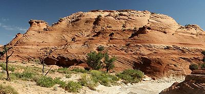
dome exhibiting extensive layering
Stratigraphy
Stratigraphy, a branch of geology, studies rock layers and layering . It is primarily used in the study of sedimentary and layered volcanic rocks....
and crossbedding, remnants of its formation from sand dune
Dune
In physical geography, a dune is a hill of sand built by wind. Dunes occur in different forms and sizes, formed by interaction with the wind. Most kinds of dunes are longer on the windward side where the sand is pushed up the dune and have a shorter "slip face" in the lee of the wind...
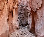
s. Just downstream from the mouth of the Narrows, Peek-a-boo Gulch has carved an even narrower channel into the sandstone, leading to a tube which empties into the main wash 10 feet (3 m) above the main streambed. Further down, Spooky Gulch shows just what "narrow" means. Despite being over 30 feet (10 m) deep, the channel rarely widens to more than 15 inches (0.5 m), forcing hikers to walk sideways. Its name comes from how little sunlight penetrates to the bottom of the slot. Finally, further down the main wash, Brimstone Gulch exhibits many of the features of the larger slot canyons in the area.
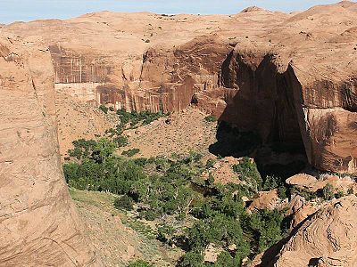
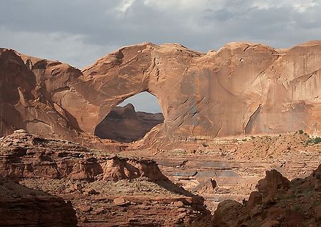
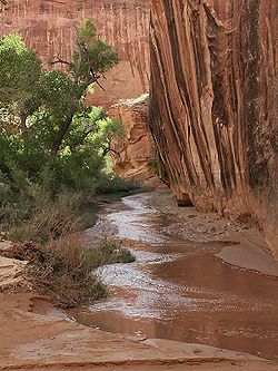
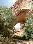
The main canyon of Coyote Gulch has numerous features of interest. The sandy streambed, typically just a few inches deep, provides a scenic path for wading through the trees and vegetation lining the bottom of the canyon. Near the middle of the canyon is Jacob Hamblin
Jacob Hamblin
Jacob Vernon Hamblin was a Western pioneer, Mormon missionary, and diplomat to various Native American Tribes of the Southwest and Great Basin. During his life, he helped settle large areas of southern Utah and northern Arizona where he was seen as an honest broker between Mormon settlers and the...
Arch (also known as Lobo Arch), large enough to reach under an overhang on the opposite side. Further down the canyon is Coyote Natural Bridge, a small hole carved in a large sandstone fin. Still further downstream is Cliff Arch, a jug-handle style arch in the north wall of the canyon. Finally, just outside the mouth of the canyon and high above the Escalante River, is Stevens Arch. With an opening approximately 220 feet (67 m) wide and 160 feet (49 m) high , it is an excellent example of the arch
Natural arch
A natural arch or natural bridge is a natural geological formation where a rock arch forms, with an opening underneath. Most natural arches form as a narrow ridge, walled by cliffs, become narrower from erosion, with a softer rock stratum under the cliff-forming stratum gradually eroding out until...
-forming ability of Navajo sandstone
Navajo Sandstone
Navajo Sandstone is a geologic formation in the Glen Canyon Group that is spread across the U.S. states of northern Arizona, northwest Colorado, and Utah; as part of the Colorado Plateau province of the United States...
.
There is also an excellent Fremont rock art panel about a half mile downstream from Coyote Natural Bridge on the north side of the canyon. In addition, there are numerous small waterfalls and cascades in the canyon between Jacob Hamblin Arch and the confluence with the Escalante River. Some of these can be easily climbed, but others must be bypassed.
| |
||||||||
 |
 |
 |
||||||
| Peek-a-Boo Gulch | Sandstone Dome | Streambed | ||||||
 |
 |
 |
||||||
| Lobo Arch | Dry Fork Narrows | Spooky Gulch | ||||||
Further reading
- "Hiking the Escalante", by Rudi Lambrechtse (1985), ISBN 0-915272-27-X
- "Canyon Hiking Guide to the Colorado Plateau", by Michael R. Kelsey (1995), ISBN 0-944510-11-6