
.gif)
County Route 577 (New Jersey)
Encyclopedia
County Route 577, abbreviated CR 577, is a county highway
in the U.S. state
of New Jersey
. The highway extends 9.96 miles (16 km) from Springfield Avenue (Route 124
) in Springfield Township
to Bloomfield Avenue (CR 506
) in Verona
.
 CR 577 begins at an intersection with Route 124 in Springfield Township
near the western terminus of Route 82. The highway originally started further south, at the intersection of Broad Street and Springfield Avenue in Westfield
; Broad Street and eastbound Springfield Avenue are CR 509
, while CR 577 went west and north on Springfield Avenue, which becomes Meisel Avenue as it enters Springfield. This route was changed in the past from CR 577 to CR 509 Spur (although the old signage was often left intact) but may have been changed back. In downtown Springfield, where most of the major streets are one-way, Maple Avenue carries the nominal route northbound to the official southern terminus, while Meisel Avenue carries the southbound traffic.
From the official southern terminus, the route heads north as two-lane undivided Main Street, which is municipally maintained. The road runs through suburban residential development, passing over I-78
and crossing into Millburn
in Essex County
. In Millburn, CR 577 reaches a junction with CR 527
, at which point the route turns east onto a one-way pair
that is county maintained. Northbound CR 577 follows three-lane Millburn Avenue and southbound CR 577 follows two-lane Essex Avenue on this pairing, which passes through the commercial downtown of Millburn. At the end of the one-way pair, the route becomes four-lane undivided Millburn Avenue and continues east through a mix of homes and businesses. At the Wyoming Avenue intersection, CR 577 turns northeast onto that road while CR 630 continues along Millburn Avenue.
Wyoming Avenue, which is a two-lane road, carries the route over New Jersey Transit
’s Morristown Line
and into wooded residential neighborhoods a short distance to the east of the South Mountain Reservation
. The road continues through Maplewood
before crossing into South Orange
, where it reaches CR 510
. At this point, CR 577 turns east to form a brief concurrency
with CR 510, which is four-lane South Orange Avenue. Upon splitting from that route, CR 577 continues northeast on two-lane Wyoming Avenue. The road enters West Orange
and becomes Gregory Avenue. Here, the route crosses CR 508
prior to reaching the CR 660 junction.
At CR 660, CR 577 turns north onto Mt. Pleasant Avenue and crosses First Watchung Mountain
as the road makes a turn to the west. This road is four lanes at first, soon narrowing to two lanes. After crossing the mountain, the route intersects Prospect Avenue, which it turns north onto. At this intersection, Prospect Avenue heads south as CR 677 while Mt. Pleasant Avenue continues west as Route 10. Along Prospect Avenue, CR 577 is a two-lane undivided road that turns into a four-lane divided highway
as it passes through commercial areas. The route comes to an interchange with I-280
and becomes a five-lane undivided road past that point, with three northbound lanes and two southbound lanes. At the CR 611 intersection, CR 577 becomes three lanes with two lanes southbound and one lane northbound The road runs between homes and the Montclair Golf Course to the west and the Eagle Rock Reservation
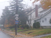
to the east before becoming two lanes and crossing into Verona
. In Verona, CR 577 passes residences before reaching its end at an intersection with CR 506
. Past this intersection, the road continues north as Route 23.
County highway
A county highway is a road in the United States and in the Canadian province of Ontario that is designated and/or maintained by the county highway department...
in the U.S. state
U.S. state
A U.S. state is any one of the 50 federated states of the United States of America that share sovereignty with the federal government. Because of this shared sovereignty, an American is a citizen both of the federal entity and of his or her state of domicile. Four states use the official title of...
of New Jersey
New Jersey
New Jersey is a state in the Northeastern and Middle Atlantic regions of the United States. , its population was 8,791,894. It is bordered on the north and east by the state of New York, on the southeast and south by the Atlantic Ocean, on the west by Pennsylvania and on the southwest by Delaware...
. The highway extends 9.96 miles (16 km) from Springfield Avenue (Route 124
Route 124 (New Jersey)
Route 124 is a state highway in the northern part of New Jersey in the United States that is long. It is the eastern section of what used to be Route 24 before that road was realigned to its current freeway alignment. The western end is at an intersection with U.S...
) in Springfield Township
Springfield Township, Union County, New Jersey
Township of Springfield is a township in Union County, New Jersey, United States. As of the 2010 United States Census, the township population increased to a record high of 15,817....
to Bloomfield Avenue (CR 506
County Route 506 (New Jersey)
County Route 506 is a county highway in the U.S. state of New Jersey. The highway extends 10.74 miles from Oak Road in Fairfield to Route 7 at the Passaic River in Belleville.- Route description :...
) in Verona
Verona, New Jersey
Verona is a township in Essex County, New Jersey, United States. As of the 2010 United States Census, the township population was 13,332.In 2008, New Jersey Monthly magazine ranked Verona #1 in Essex County and #3 in New Jersey as "Top Places to Live in New Jersey".-History:Verona and several...
.
Route description
Springfield Township, Union County, New Jersey
Township of Springfield is a township in Union County, New Jersey, United States. As of the 2010 United States Census, the township population increased to a record high of 15,817....
near the western terminus of Route 82. The highway originally started further south, at the intersection of Broad Street and Springfield Avenue in Westfield
Westfield, New Jersey
Westfield is a town in Union County, New Jersey, United States. As of the 2010 United States Census, the town population was 30,316. The old village area, now the downtown district, was settled in 1720 as part of the Elizabethtown Tract....
; Broad Street and eastbound Springfield Avenue are CR 509
County Route 509 (New Jersey)
County Route 509 is a county highway in the U.S. state of New Jersey. The highway extends 25.78 miles from North Avenue in Westfield to Straight Street in Paterson....
, while CR 577 went west and north on Springfield Avenue, which becomes Meisel Avenue as it enters Springfield. This route was changed in the past from CR 577 to CR 509 Spur (although the old signage was often left intact) but may have been changed back. In downtown Springfield, where most of the major streets are one-way, Maple Avenue carries the nominal route northbound to the official southern terminus, while Meisel Avenue carries the southbound traffic.
From the official southern terminus, the route heads north as two-lane undivided Main Street, which is municipally maintained. The road runs through suburban residential development, passing over I-78
Interstate 78 in New Jersey
Interstate 78 is an east–west route stretching from Union Township, Lebanon County, Pennsylvania to New York City. In New Jersey, I-78 is called the Phillipsburg–Newark Expressway and the Newark Bay Extension of the New Jersey Turnpike...
and crossing into Millburn
Millburn, New Jersey
Millburn is a township in Essex County, New Jersey, United States. As of the 2010 United States Census, the township population was 20,149.Millburn Township was created as a township by an act of the New Jersey Legislature on March 20, 1857, from portions of Springfield Township.Millburn also...
in Essex County
Essex County, New Jersey
Essex County is a county located in the northeastern part of the U.S. state of New Jersey. As of the United States 2010 Census, the population was 783,969, ranking it third in the state after Bergen County and Middlesex County; Essex County's population has declined from 786,147 as of the bureau's...
. In Millburn, CR 577 reaches a junction with CR 527
County Route 527 (New Jersey)
County Route 527 is a county highway in the U.S. state of New Jersey. The highway extends from Main Street in Toms River Township to Pompton Avenue in Cedar Grove. It is the second longest county highway in New Jersey after Route 519. It was first given the number 527 in 1954...
, at which point the route turns east onto a one-way pair
One-way pair
A one-way pair, one-way couple, or just couplet is a pair of parallel, usually one-way streets that carry opposite directions of a signed route or major traffic flow, or sometimes opposite directions of a bus or streetcar route....
that is county maintained. Northbound CR 577 follows three-lane Millburn Avenue and southbound CR 577 follows two-lane Essex Avenue on this pairing, which passes through the commercial downtown of Millburn. At the end of the one-way pair, the route becomes four-lane undivided Millburn Avenue and continues east through a mix of homes and businesses. At the Wyoming Avenue intersection, CR 577 turns northeast onto that road while CR 630 continues along Millburn Avenue.
Wyoming Avenue, which is a two-lane road, carries the route over New Jersey Transit
New Jersey Transit
The New Jersey Transit Corporation is a statewide public transportation system serving the United States state of New Jersey, and New York, Orange, and Rockland counties in New York State...
’s Morristown Line
Morristown Line
The Morristown Line is one of New Jersey Transit's commuter lines and is one of two branches that run along the Morris and Essex Lines. Out of 60 inbound and 58 outbound daily weekday trains, 28 inbound and 26 outbound trains use the Kearny Connection to Secaucus Junction and New York Penn...
and into wooded residential neighborhoods a short distance to the east of the South Mountain Reservation
South Mountain Reservation
South Mountain Reservation covers 2,047.14 acres in central Essex County, New Jersey, in portions of Maplewood, and Millburn and West Orange, bordering South Orange, between the first and second ridges of the Watchung Mountains....
. The road continues through Maplewood
Maplewood, New Jersey
Maplewood is a township in Essex County, New Jersey, United States. As of the 2010 United States Census, the township population was 23,867.-History:...
before crossing into South Orange
South Orange, New Jersey
-Demographics:As of the census of 2000, there were 16,964 people, 5,522 households, and 3,766 families residing in the township. The population density was 5,945.3 people per square mile . There were 5,671 housing units at an average density of 1,987.5 per square mile...
, where it reaches CR 510
County Route 510 (New Jersey)
County Route 510 is a county highway in the U.S. state of New Jersey. The highway extends from North Road in Chester to McCarter Highway in Newark.A separate, westbound portion of CR 510 stretches through Morristown.-Morris County:...
. At this point, CR 577 turns east to form a brief concurrency
Concurrency (road)
A concurrency, overlap, or coincidence in a road network is an instance of one physical road bearing two or more different highway, motorway, or other route numbers...
with CR 510, which is four-lane South Orange Avenue. Upon splitting from that route, CR 577 continues northeast on two-lane Wyoming Avenue. The road enters West Orange
West Orange, New Jersey
West Orange is a township in central Essex County, New Jersey, United States. As of the 2010 United States Census, the township population was 46,207...
and becomes Gregory Avenue. Here, the route crosses CR 508
County Route 508 (New Jersey)
County Route 508 is a county highway in the U.S. state of New Jersey. The highway extends 16.14 miles from Mount Pleasant Avenue in Livingston to Belleville Turnpike in Kearny.-Essex County:...
prior to reaching the CR 660 junction.
At CR 660, CR 577 turns north onto Mt. Pleasant Avenue and crosses First Watchung Mountain
Watchung Mountains
The Watchung Mountains are a group of three long low ridges of volcanic origin, between 400 ft. and 500 ft. high, lying parallel to each other in northern New Jersey in the United States...
as the road makes a turn to the west. This road is four lanes at first, soon narrowing to two lanes. After crossing the mountain, the route intersects Prospect Avenue, which it turns north onto. At this intersection, Prospect Avenue heads south as CR 677 while Mt. Pleasant Avenue continues west as Route 10. Along Prospect Avenue, CR 577 is a two-lane undivided road that turns into a four-lane divided highway
Divided Highway
Divided Highway is a compilation album by American rock band The Doobie Brothers, released in 2003. . All tracks are taken from the albums Cycles and Brotherhood .-Track listing:...
as it passes through commercial areas. The route comes to an interchange with I-280
Interstate 280 (New Jersey)
Interstate 280 is a Interstate Highway in the U.S. state of New Jersey. It provides a spur from I-80 in Parsippany-Troy Hills, Morris County to Newark, and I-95 Interstate 280 (abbreviated I-280) is a Interstate Highway in the U.S. state of New Jersey. It provides a spur from I-80 in...
and becomes a five-lane undivided road past that point, with three northbound lanes and two southbound lanes. At the CR 611 intersection, CR 577 becomes three lanes with two lanes southbound and one lane northbound The road runs between homes and the Montclair Golf Course to the west and the Eagle Rock Reservation
Eagle Rock Reservation
Eagle Rock Reservation is a 408.33-acre forest reserve and recreational park in the First Watchung Mountain of New Jersey , primarily in the communities of West Orange, Montclair, and Verona...
to the east before becoming two lanes and crossing into Verona
Verona, New Jersey
Verona is a township in Essex County, New Jersey, United States. As of the 2010 United States Census, the township population was 13,332.In 2008, New Jersey Monthly magazine ranked Verona #1 in Essex County and #3 in New Jersey as "Top Places to Live in New Jersey".-History:Verona and several...
. In Verona, CR 577 passes residences before reaching its end at an intersection with CR 506
County Route 506 (New Jersey)
County Route 506 is a county highway in the U.S. state of New Jersey. The highway extends 10.74 miles from Oak Road in Fairfield to Route 7 at the Passaic River in Belleville.- Route description :...
. Past this intersection, the road continues north as Route 23.