
South Mountain Reservation
Encyclopedia
South Mountain Reservation covers 2,047.14 acres (8 km2) in central Essex County
, New Jersey
, in portions of Maplewood
, and Millburn
and West Orange
, bordering South Orange
, between the first and second ridges of the Watchung Mountains
.
In 1896, John Durand, the son of Asher Brown Durand
, described the mountain that includes South Mountain Reservation as
In 1680, wolves, bears and cougars were observed in the area, and there was a bounty on them.
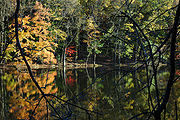
The reservation has changed only slightly through the years. It's been preserved primarily in its wild state. Woodlands abound in a variety of hardwood trees, and tall hemlocks tower above streams, creeks and ponds. The west branch of the Rahway River
flows through the valley. A reservoir and watershed owned by the City of Orange
lies in the northern tract.
Turtle Back Zoo
and the South Mountain Arena lie within its boundaries. There are vistas of New York City
, Elizabeth
, Union Township
, Staten Island
. Hemlock Falls is a dramatic feature; neighboring Blackrock Falls is a picturesque smaller cascade.
In front of the pond called Campbell's Pond is a factory that was abandoned when its interior burned. The adjacent pond has a bridge going across it that is falling apart and is considered dangerous to cross over.
 The reservation was built from land purchases begun in 1895. It took a decade to untangle the deeds and assemble all the lands at South Mountain. Before he delegated design of the Essex Parks to his stepson's firm, Frederick Law Olmsted
visited the newly acquired reservation. He regarded it as some of the most beautiful and promising terrain he had ever seen anywhere. The design of South Mountain was finalized by the Olmsted Brothers
in stages over the years. A good deal of construction work — trails, footbridge
s, shelters, etc. — was carried out by the Civilian Conservation Corps
in the 1930s.
The roadway on Crest Drive has been closed to vehicular traffic at the old deer paddock so that you may enjoy a leisurely walk down to Washington Rock. This is the Park System's bona fide Revolutionary War historic site, dating back to the late 18th century when Beacon Signal Station 9 was located here—one of 23 beacons built by General Washington to observe British troop movements quartered on Staten Island and New York City.
It was from this outlook that, on June 23, 1780, Essex County and Newark Militia were first warned that the British had launched an attack westward toward "the Gap," (Hobart Gap
), a natural pathway to Washington's troops encamped at Morris Town. In a pincer movement designed to gain access to the Gap, Hessian troops fought bitterly along Vaux Hall Road, while the British advanced along Galloping Hill Road, until they were repelled, the Hessians at the base of the mountain and the British in Millburn—called Millville in those days. Washington Rock served again as a lookout for the Army when reactivated during the War of 1812.
Photographs
Essex County, New Jersey
Essex County is a county located in the northeastern part of the U.S. state of New Jersey. As of the United States 2010 Census, the population was 783,969, ranking it third in the state after Bergen County and Middlesex County; Essex County's population has declined from 786,147 as of the bureau's...
, New Jersey
New Jersey
New Jersey is a state in the Northeastern and Middle Atlantic regions of the United States. , its population was 8,791,894. It is bordered on the north and east by the state of New York, on the southeast and south by the Atlantic Ocean, on the west by Pennsylvania and on the southwest by Delaware...
, in portions of Maplewood
Maplewood, New Jersey
Maplewood is a township in Essex County, New Jersey, United States. As of the 2010 United States Census, the township population was 23,867.-History:...
, and Millburn
Millburn, New Jersey
Millburn is a township in Essex County, New Jersey, United States. As of the 2010 United States Census, the township population was 20,149.Millburn Township was created as a township by an act of the New Jersey Legislature on March 20, 1857, from portions of Springfield Township.Millburn also...
and West Orange
West Orange, New Jersey
West Orange is a township in central Essex County, New Jersey, United States. As of the 2010 United States Census, the township population was 46,207...
, bordering South Orange
South Orange, New Jersey
-Demographics:As of the census of 2000, there were 16,964 people, 5,522 households, and 3,766 families residing in the township. The population density was 5,945.3 people per square mile . There were 5,671 housing units at an average density of 1,987.5 per square mile...
, between the first and second ridges of the Watchung Mountains
Watchung Mountains
The Watchung Mountains are a group of three long low ridges of volcanic origin, between 400 ft. and 500 ft. high, lying parallel to each other in northern New Jersey in the United States...
.
In 1896, John Durand, the son of Asher Brown Durand
Asher Brown Durand
Asher Brown Durand was an American painter of the Hudson River School.-Early life:Durand was born in and eventually died in Maplewood, New Jersey , the eighth of eleven children; his father was a watchmaker and a silversmith.Durand was apprenticed to an engraver from 1812 to 1817, later entering...
, described the mountain that includes South Mountain Reservation as
- “a wilderness, as it probably existed at the time of Hendrick Hudson, a primitive forest abounding with deer and other wild animals, and traversed by streams alive with trout. Game was plentiful – partridges, quail, woodcock, rabbits, squirrels of every species, raccoons and foxes; while occasionally a hungry bear that had trespassed on the farmyards in the vicinity would be tracked to its den and shot.”
In 1680, wolves, bears and cougars were observed in the area, and there was a bounty on them.
The reservation has changed only slightly through the years. It's been preserved primarily in its wild state. Woodlands abound in a variety of hardwood trees, and tall hemlocks tower above streams, creeks and ponds. The west branch of the Rahway River
Rahway River
The Rahway River is a river, approximately 24 mi long, in northeastern New Jersey in the United States. The river drains part of the suburban and urbanized area of New Jersey west of New York City. Part of the extended area of New York Harbor, the river empties into the Arthur Kill. In its...
flows through the valley. A reservoir and watershed owned by the City of Orange
Orange, New Jersey
The City of Orange is a city and township in Essex County, New Jersey, United States. As of the 2010 United States Census, the township population was 30,134...
lies in the northern tract.
Turtle Back Zoo
Turtle Back Zoo
Turtle Back Zoo, is a zoo in West Orange, New Jersey. Situated on the South Mountain Reservation, it is part of the Essex County Park System, the oldest county park system in the United States. Founded in 1963, the zoo was originally a showcase for animals indigenous to New Jersey, but currently...
and the South Mountain Arena lie within its boundaries. There are vistas of New York City
New York City
New York is the most populous city in the United States and the center of the New York Metropolitan Area, one of the most populous metropolitan areas in the world. New York exerts a significant impact upon global commerce, finance, media, art, fashion, research, technology, education, and...
, Elizabeth
Elizabeth, New Jersey
Elizabeth is a city in Union County, New Jersey, United States. As of the 2010 United States Census, the city had a total population of 124,969, retaining its ranking as New Jersey's fourth largest city with an increase of 4,401 residents from its 2000 Census population of 120,568...
, Union Township
Union Township, Union County, New Jersey
Union is a Township in Union County, New Jersey, United States. In the 18th century, the area that is now Union was then called Connecticut Farms...
, Staten Island
Staten Island
Staten Island is a borough of New York City, New York, United States, located in the southwest part of the city. Staten Island is separated from New Jersey by the Arthur Kill and the Kill Van Kull, and from the rest of New York by New York Bay...
. Hemlock Falls is a dramatic feature; neighboring Blackrock Falls is a picturesque smaller cascade.
In front of the pond called Campbell's Pond is a factory that was abandoned when its interior burned. The adjacent pond has a bridge going across it that is falling apart and is considered dangerous to cross over.
History
Frederick Law Olmsted
Frederick Law Olmsted was an American journalist, social critic, public administrator, and landscape designer. He is popularly considered to be the father of American landscape architecture, although many scholars have bestowed that title upon Andrew Jackson Downing...
visited the newly acquired reservation. He regarded it as some of the most beautiful and promising terrain he had ever seen anywhere. The design of South Mountain was finalized by the Olmsted Brothers
Olmsted Brothers
The Olmsted Brothers company was an influential landscape design firm in the United States, formed in 1898 by stepbrothers John Charles Olmsted and Frederick Law Olmsted, Jr. .-History:...
in stages over the years. A good deal of construction work — trails, footbridge
Footbridge
A footbridge or pedestrian bridge is a bridge designed for pedestrians and in some cases cyclists, animal traffic and horse riders, rather than vehicular traffic. Footbridges complement the landscape and can be used decoratively to visually link two distinct areas or to signal a transaction...
s, shelters, etc. — was carried out by the Civilian Conservation Corps
Civilian Conservation Corps
The Civilian Conservation Corps was a public work relief program that operated from 1933 to 1942 in the United States for unemployed, unmarried men from relief families, ages 18–25. A part of the New Deal of President Franklin D...
in the 1930s.
The roadway on Crest Drive has been closed to vehicular traffic at the old deer paddock so that you may enjoy a leisurely walk down to Washington Rock. This is the Park System's bona fide Revolutionary War historic site, dating back to the late 18th century when Beacon Signal Station 9 was located here—one of 23 beacons built by General Washington to observe British troop movements quartered on Staten Island and New York City.
It was from this outlook that, on June 23, 1780, Essex County and Newark Militia were first warned that the British had launched an attack westward toward "the Gap," (Hobart Gap
Hobart Gap
The Hobart Gap is a strategic pass and road through the Watchung Mountains in Northern New Jersey. The confluence of the two branches of the Rahway River is located here...
), a natural pathway to Washington's troops encamped at Morris Town. In a pincer movement designed to gain access to the Gap, Hessian troops fought bitterly along Vaux Hall Road, while the British advanced along Galloping Hill Road, until they were repelled, the Hessians at the base of the mountain and the British in Millburn—called Millville in those days. Washington Rock served again as a lookout for the Army when reactivated during the War of 1812.
External links
- Hike of the Week at South Mountain Reservation
- South Mountain Conservancy
- Weekly Trail Running in South Mountain Reservation
- Geology of South Mountain Reservation
- NJ.com News Article
- Eessex County Parks System
- NY-NJTC: South Mountain Reservation Trail Details and Info
Photographs