
.gif)
County Route 502 (New Jersey)
Encyclopedia
County Route 502 is a county highway
in the U.S. state
of New Jersey
. The highway extends 23.79 miles (38.29 kilometers) from Paterson-Hamburg Turnpike (CR 504
) in Wayne
to Palisades Boulevard (US 9W
) in Alpine
.
Route 502 is a very important east–west route in the northern part of Bergen County
. north–south travel in the county is available via Route 208 and Route 17, the Garden State Parkway
, Route 9W and the Palisades Interstate Parkway
. In contrast, the only east–west route in the area is Route 4, from Paterson
to Fort Lee
. Thus, the north area of the county relies heavily on 502 for east–west travel. Farthest north, NY 59
or the New York State Thruway
can be used as east–west alternatives to 502.
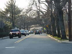
502 comprises Franklin Lakes Avenue, Wyckoff Avenue, Franklin Turnpike (break), Hollywood Avenue, East Saddle River Road (break), Weirimus Road, Washington Avenue, Old Hook Road, High Street, Closter Dock Road and its end at US 9W. In the extreme west of Bergen County, 502 is a pseudo-highway with no-left-turn jughandles, u-turns and stoplights. When 502 runs through Harrington Park
, Emerson
, and Westwood
, it is a four-lane major avenue. As it runs through Washington Township, Ho-Ho-Kus
and Waldwick
it is a major two-lane road. As it continues west, it is mostly a two-lane road with occasional expansions into a four-lane avenue.
 CR 502 begins at an intersection with CR 504
in Wayne
, Passaic County
, heading northwest on four-lane undivided Berdan Avenue through commercial areas. The route turns north as it passes between the Point View Reservoir to the west and residential neighborhoods to the east, intersecting CR 681. From here, the road heads into forested areas with some homes, crossing into Bergen County
, at which point it forms the border between Oakland
to the west and Franklin Lakes
to the east as two-lane Breakneck Road. CR 502 fully enters Oakland, where it intersects CR 93 and turns southeast onto Long Hill Road. The route continues into Franklin Lakes and runs through residential areas as Franklin Lakes Road, intersecting CR 117 before turning east near Franklin Lake and reaching a traffic circle
at CR 89. Upon reaching the CR 97 (Ewing Avenue) intersection, CR 502 turns north onto Ewing Avenue, with CR 93 continuing east on Franklin Lakes Road. The road passes more wooded areas of homes as it reaches an interchange with Route 208. A short distance later, the route intersects CR 84 and makes a turn east onto Franklin Avenue. The road crosses into Wyckoff
and crosses CR 87 as it heads into the commercial downtown. The route crosses the New York, Susquehanna and Western Railway
and passes a mix of homes and businesses as it comes to an intersection with CR 87S and CR 84. CR 502 heads back into wooded residential neighborhoods and enters Waldwick
, where it becomes Wyckoff Avenue and reaches a junction with CR 81. The route passes over New Jersey Transit
's Main Line
/Bergen County Line
and widens to four lanes as it comes into businesses areas and reaches an intersection with CR 507
.At this point, CR 502 turns south to form a concurrency
with CR 507, heading southeast along two-lane Franklin Turnpike. The road heads into Ho-Ho-Kus
and passes a mix of homes and businesses before CR 502 splits from CR 507 by heading east on Hollywood Avenue. At this intersection CR 502 Truck heads south along CR 507. CR 502 continues east through wooded residential areas and intersects CR 77 and CR 502 Truck again. A short distance later, the route comes to an interchange with Route 17.
From this interchange, CR 502 continues across the Saddle River and reaches an intersection with CR 75, where the route turns south onto East Saddle River Road. The road intersects CR 112 and makes a sharp turn east to a junction with CR 75. At this point, the route becomes Weirmus Road and turns northeast before CR 112 splits to the north on Weirmus Road. CR 502 continues east into Washington Township as Washington Avenue, crossing CR 71 before coming to a partial interchange with the Garden State Parkway
that has access to and from the southbound direction of the parkway. The road crosses CR 63 and continues through residential neighborhoods, crossing into Westwood
. Here, the route intersects CR 110 and CR 59 before crossing New Jersey Transit's Pascack Valley Line
and meeting CR 104 in the commercial downtown. At this point, CR 502 turns southeast onto Broadway and runs to the east of the Pascack Valley Line, passing the Westwood Station
. The road curves east away from the railroad tracks, widening to four lanes as it comes to the CR 503
junction. After this, CR 502 becomes Old Hook Road and continues through commercial areas, briefly becoming a divided highway
at the entrance to the Hackensack University Medical Center North at Pascack Valley
. The road enters Emerson
at the Main Street intersection and runs through wooded areas before coming into Harrington Park
and intersecting CR 104. CR 502 crosses the Oradell Reservoir
into Closter
and becomes High Street as it crosses CSX's River Subdivision and comes to the CR 39 junction. From here, the route narrows to two lanes and continues through wooded residential areas, crossing CR 505
before turning southeast and crossing CSX's Northern Branch
. At the CR 102 intersection, CR 502 turns south onto Closter Dock Road, with CR 104 continuing along High Street. The route intersects CR 41 and curves southeast onto Old Closter Dock Road, coming to a junction with CR 35 before crossing CR 501
. At the Anderson Avenue intersection, CR 502 crosses into Alpine
and continues to its eastern terminus at US 9W
.
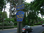
County Route 502 Truck is a bypass of a section of CR 502 in Ho-Ho-Kus, New Jersey
. The route travels 0.75 miles, following part of CR 77 and CR 507
. It was designated so that trucks could detour around a section of CR 502 westbound where trucks have been banned due to a steeply graded intersection. CR 502 Truck, while signed, is not an official route, and it has no publicly available straight line diagram. However, its length may be determined by utilizing the straight line diagrams for CR 77 and CR 507.
The road begins at the intersection of CR 502 and Hollywood Ave and CR 77 Sheridan Ave in Ho-Ho-Kus
. Here, trucks must make a left onto CR 77 to avoid a steep incline at the upcoming intersection of CR 502 and CR 507
. Traveling south into downtown Ho-Ho-Kus, CR 502 Truck follows the same route as CR 77 until coming to a skewed intersection with the Franklin Turnpike and North Maple Ave. To the east, CR 62 enters the intersection as the Franklin Turnpike. Ahead and somewhat to the east, CR 507 emerges as North Maple Ave and turns to follow the Franklin Turnpike to the west. CR 502 Truck makes a right turn at the above mentioned intersection and follows CR 507 up a hill for 0.39 miles until it reunites with CR 502 at an intersection with Hollywood Ave. CR 502 then continues in the same direction as CR 507.
County highway
A county highway is a road in the United States and in the Canadian province of Ontario that is designated and/or maintained by the county highway department...
in the U.S. state
U.S. state
A U.S. state is any one of the 50 federated states of the United States of America that share sovereignty with the federal government. Because of this shared sovereignty, an American is a citizen both of the federal entity and of his or her state of domicile. Four states use the official title of...
of New Jersey
New Jersey
New Jersey is a state in the Northeastern and Middle Atlantic regions of the United States. , its population was 8,791,894. It is bordered on the north and east by the state of New York, on the southeast and south by the Atlantic Ocean, on the west by Pennsylvania and on the southwest by Delaware...
. The highway extends 23.79 miles (38.29 kilometers) from Paterson-Hamburg Turnpike (CR 504
County Route 504 (New Jersey)
County Route 504 is a county highway in the U.S. state of New Jersey. The highway extends 15.94 miles from Main Street in Montville County Route 504 is a county highway in the U.S. state of New Jersey. The highway extends 15.94 miles (25.65 kilometers) from Main Street in Montville County Route...
) in Wayne
Wayne, New Jersey
Wayne is a Township in Passaic County, New Jersey, United States, located less than from midtown Manhattan. As of the United States 2000 Census, the township had a total population of 54,069....
to Palisades Boulevard (US 9W
U.S. Route 9W
U.S. Route 9W is a north–south U.S. Highway in the states of New Jersey and New York. It begins on Fletcher Avenue in Fort Lee, New Jersey as it crosses the US 1 & 9, US 46, and the Interstate 95 approaches to the George Washington Bridge, where it heads north up the west...
) in Alpine
Alpine, New Jersey
Alpine is a borough in Bergen County, New Jersey, United States. It is a suburb of New York City, located northwest of Midtown Manhattan. As of the 2010 United States Census, the borough population was 1,849....
.
Route 502 is a very important east–west route in the northern part of Bergen County
Bergen County, New Jersey
Bergen County is the most populous county of the state of New Jersey, United States. As of the 2010 United States Census, its population was 905,116. The county is part of the New York City Metropolitan Area. Its county seat is Hackensack...
. north–south travel in the county is available via Route 208 and Route 17, the Garden State Parkway
Garden State Parkway
The Garden State Parkway is a 172.4-mile limited-access toll parkway that stretches the length of New Jersey from the New York line at Montvale, New Jersey, to Cape May at New Jersey's southernmost tip. Its name refers to New Jersey's nickname, the "Garden State." Most New Jersey residents refer...
, Route 9W and the Palisades Interstate Parkway
Palisades Interstate Parkway
The Palisades Interstate Parkway is a long limited-access highway in the U.S. states of New Jersey and New York. The parkway is a major commuter route into New York City from Rockland and Orange counties in New York and Bergen County in New Jersey...
. In contrast, the only east–west route in the area is Route 4, from Paterson
Paterson, New Jersey
Paterson is a city serving as the county seat of Passaic County, New Jersey, United States. As of the 2010 United States Census, its population was 146,199, rendering it New Jersey's third largest city and one of the largest cities in the New York City Metropolitan Area, despite a decrease of 3,023...
to Fort Lee
Fort Lee, New Jersey
Fort Lee is a borough in Bergen County, New Jersey, United States. As of the 2010 United States Census, the borough population was 35,345. Located atop the Hudson Palisades, the borough is the western terminus of the George Washington Bridge...
. Thus, the north area of the county relies heavily on 502 for east–west travel. Farthest north, NY 59
New York State Route 59
New York State Route 59 is an east–west state highway in southern Rockland County, New York, in the United States. The route extends for from NY 17 in Hillburn to U.S. Route 9W in Nyack. In Suffern, it has a concurrency with US 202 for . NY 59 runs parallel to the New...
or the New York State Thruway
New York State Thruway
The New York State Thruway is a system of limited-access highways located within the state of New York in the United States. The system, known officially as the Governor Thomas E. Dewey Thruway for former New York Governor Thomas E. Dewey, is operated by the New York State Thruway Authority and...
can be used as east–west alternatives to 502.
502 comprises Franklin Lakes Avenue, Wyckoff Avenue, Franklin Turnpike (break), Hollywood Avenue, East Saddle River Road (break), Weirimus Road, Washington Avenue, Old Hook Road, High Street, Closter Dock Road and its end at US 9W. In the extreme west of Bergen County, 502 is a pseudo-highway with no-left-turn jughandles, u-turns and stoplights. When 502 runs through Harrington Park
Harrington Park, New Jersey
Harrington Park is a borough in Bergen County, New Jersey, United States. As of the 2010 United States Census, the borough population was 4,664....
, Emerson
Emerson, New Jersey
Emerson is a borough in Bergen County, New Jersey, United States, a suburb in the New York metropolitan area. As of the 2010 United States Census, the borough population was 7,401....
, and Westwood
Westwood, New Jersey
Westwood is a borough in Bergen County, New Jersey, United States. As of the 2010 United States Census, the borough population was 10,908....
, it is a four-lane major avenue. As it runs through Washington Township, Ho-Ho-Kus
Ho-Ho-Kus, New Jersey
Ho-Ho-Kus is a borough in Bergen County, New Jersey, United States. As of the 2010 census, the borough population was 4,078. It is the home of several historical landmarks, including the Ho-Ho-Kus Inn and The Hermitage....
and Waldwick
Waldwick, New Jersey
Waldwick is a borough in Bergen County, New Jersey, United States. As of the 2010 United States Census, the borough population was 9,625.-Geography:Waldwick is located at ....
it is a major two-lane road. As it continues west, it is mostly a two-lane road with occasional expansions into a four-lane avenue.
Route description
County Route 504 (New Jersey)
County Route 504 is a county highway in the U.S. state of New Jersey. The highway extends 15.94 miles from Main Street in Montville County Route 504 is a county highway in the U.S. state of New Jersey. The highway extends 15.94 miles (25.65 kilometers) from Main Street in Montville County Route...
in Wayne
Wayne, New Jersey
Wayne is a Township in Passaic County, New Jersey, United States, located less than from midtown Manhattan. As of the United States 2000 Census, the township had a total population of 54,069....
, Passaic County
Passaic County, New Jersey
Passaic County is a county located in the U.S. state of New Jersey. As of the 2010 Census, the population was 501,226. Its county seat is Paterson...
, heading northwest on four-lane undivided Berdan Avenue through commercial areas. The route turns north as it passes between the Point View Reservoir to the west and residential neighborhoods to the east, intersecting CR 681. From here, the road heads into forested areas with some homes, crossing into Bergen County
Bergen County, New Jersey
Bergen County is the most populous county of the state of New Jersey, United States. As of the 2010 United States Census, its population was 905,116. The county is part of the New York City Metropolitan Area. Its county seat is Hackensack...
, at which point it forms the border between Oakland
Oakland, New Jersey
Oakland is a borough in Bergen County, New Jersey, United States. As of the 2010 United States Census, the borough population was 12,754.Oakland was incorporated as a borough by an Act of the New Jersey Legislature on April 8, 1902, from portions of Franklin Township.-History:The Van Allen House...
to the west and Franklin Lakes
Franklin Lakes, New Jersey
Franklin Lakes is a borough in Bergen County, New Jersey, United States. As of the 2010 census, the borough population was 10,590. As of the 2000 Census, Franklin Lakes had the 18th-highest per-capita income of all 566 municipalities in the state. Nationwide, Franklin Lakes ranked 17th among the...
to the east as two-lane Breakneck Road. CR 502 fully enters Oakland, where it intersects CR 93 and turns southeast onto Long Hill Road. The route continues into Franklin Lakes and runs through residential areas as Franklin Lakes Road, intersecting CR 117 before turning east near Franklin Lake and reaching a traffic circle
Traffic circle
A traffic circle or rotary is a type of circular intersection in which traffic must travel in one direction around a central island. In some countries, traffic entering the circle has the right-of-way and drivers in the circle must yield. In many other countries, traffic entering the circle must...
at CR 89. Upon reaching the CR 97 (Ewing Avenue) intersection, CR 502 turns north onto Ewing Avenue, with CR 93 continuing east on Franklin Lakes Road. The road passes more wooded areas of homes as it reaches an interchange with Route 208. A short distance later, the route intersects CR 84 and makes a turn east onto Franklin Avenue. The road crosses into Wyckoff
Wyckoff, New Jersey
Wyckoff is a township in Bergen County, New Jersey, United States. As of the 2010 United States Census, the township population was 16,696. As of the 2000 Census, Wyckoff ranked 54th in 100 highest-income places in the United States...
and crosses CR 87 as it heads into the commercial downtown. The route crosses the New York, Susquehanna and Western Railway
New York, Susquehanna and Western Railway
The New York, Susquehanna and Western Railway , also known as the Susie-Q, or simply the Susquehanna, is a Class II American freight railway operating over 500 miles of track in the northeastern states of New York, Pennsylvania and New Jersey. It was formed in 1881 from the merger of several...
and passes a mix of homes and businesses as it comes to an intersection with CR 87S and CR 84. CR 502 heads back into wooded residential neighborhoods and enters Waldwick
Waldwick, New Jersey
Waldwick is a borough in Bergen County, New Jersey, United States. As of the 2010 United States Census, the borough population was 9,625.-Geography:Waldwick is located at ....
, where it becomes Wyckoff Avenue and reaches a junction with CR 81. The route passes over New Jersey Transit
New Jersey Transit
The New Jersey Transit Corporation is a statewide public transportation system serving the United States state of New Jersey, and New York, Orange, and Rockland counties in New York State...
's Main Line
Main Line (NJ Transit)
The Main Line is a rail line owned and operated by New Jersey Transit running from Suffern, New York to Hoboken, New Jersey. It runs daily commuter service and was once the north-south main line of the Erie Lackawanna Railroad...
/Bergen County Line
Bergen County Line
The Bergen County Line is a commuter rail line and service owned and operated by New Jersey Transit in the U.S. state of New Jersey. The line loops off the Main Line between the Meadowlands and Glen Rock, with trains continuing in either direction along the Main Line...
and widens to four lanes as it comes into businesses areas and reaches an intersection with CR 507
County Route 507 (New Jersey)
County Route 507 is a county highway in the U.S. state of New Jersey. The highway extends from Harrison Avenue on the Kearny-Harrison town line to the New York state line in Mahwah. Between Ho-Ho-Kus and Mahwah, this highway is known as Franklin Turnpike...
.At this point, CR 502 turns south to form a concurrency
Concurrency (road)
A concurrency, overlap, or coincidence in a road network is an instance of one physical road bearing two or more different highway, motorway, or other route numbers...
with CR 507, heading southeast along two-lane Franklin Turnpike. The road heads into Ho-Ho-Kus
Ho-Ho-Kus, New Jersey
Ho-Ho-Kus is a borough in Bergen County, New Jersey, United States. As of the 2010 census, the borough population was 4,078. It is the home of several historical landmarks, including the Ho-Ho-Kus Inn and The Hermitage....
and passes a mix of homes and businesses before CR 502 splits from CR 507 by heading east on Hollywood Avenue. At this intersection CR 502 Truck heads south along CR 507. CR 502 continues east through wooded residential areas and intersects CR 77 and CR 502 Truck again. A short distance later, the route comes to an interchange with Route 17.
From this interchange, CR 502 continues across the Saddle River and reaches an intersection with CR 75, where the route turns south onto East Saddle River Road. The road intersects CR 112 and makes a sharp turn east to a junction with CR 75. At this point, the route becomes Weirmus Road and turns northeast before CR 112 splits to the north on Weirmus Road. CR 502 continues east into Washington Township as Washington Avenue, crossing CR 71 before coming to a partial interchange with the Garden State Parkway
Garden State Parkway
The Garden State Parkway is a 172.4-mile limited-access toll parkway that stretches the length of New Jersey from the New York line at Montvale, New Jersey, to Cape May at New Jersey's southernmost tip. Its name refers to New Jersey's nickname, the "Garden State." Most New Jersey residents refer...
that has access to and from the southbound direction of the parkway. The road crosses CR 63 and continues through residential neighborhoods, crossing into Westwood
Westwood, New Jersey
Westwood is a borough in Bergen County, New Jersey, United States. As of the 2010 United States Census, the borough population was 10,908....
. Here, the route intersects CR 110 and CR 59 before crossing New Jersey Transit's Pascack Valley Line
Pascack Valley Line
The Pascack Valley Line is a commuter rail line operated by the Hoboken Division of New Jersey Transit. The line runs north from Hoboken, New Jersey through Bergen County and into Rockland County, New York, terminating at Spring Valley. Service within New York is operated under contract with...
and meeting CR 104 in the commercial downtown. At this point, CR 502 turns southeast onto Broadway and runs to the east of the Pascack Valley Line, passing the Westwood Station
Westwood (NJT station)
Westwood Station is a New Jersey Transit rail station on the Pascack Valley Line. The station is in Westwood, New Jersey at Broadway and Westwood Avenue....
. The road curves east away from the railroad tracks, widening to four lanes as it comes to the CR 503
County Route 503 (New Jersey)
County Route 503 is a county highway in the U.S. state of New Jersey. The highway extends 17.95 miles from Paterson Plank Road in Carlstadt to the New York state line at the Montvale NJ/Pearl River NY border, where it continues as New York State Route 304...
junction. After this, CR 502 becomes Old Hook Road and continues through commercial areas, briefly becoming a divided highway
Divided Highway
Divided Highway is a compilation album by American rock band The Doobie Brothers, released in 2003. . All tracks are taken from the albums Cycles and Brotherhood .-Track listing:...
at the entrance to the Hackensack University Medical Center North at Pascack Valley
Hackensack University Medical Center North at Pascack Valley
Hackensack University Medical Center North at Pascack Valley is a satellite, free-standing emergency department located in Westwood, New Jersey, at the site of the former Pascack Valley Hospital...
. The road enters Emerson
Emerson, New Jersey
Emerson is a borough in Bergen County, New Jersey, United States, a suburb in the New York metropolitan area. As of the 2010 United States Census, the borough population was 7,401....
at the Main Street intersection and runs through wooded areas before coming into Harrington Park
Harrington Park, New Jersey
Harrington Park is a borough in Bergen County, New Jersey, United States. As of the 2010 United States Census, the borough population was 4,664....
and intersecting CR 104. CR 502 crosses the Oradell Reservoir
Oradell Reservoir
The Oradell Reservoir was formed by the Oradell Reservoir Dam placed on the Hackensack River in Bergen County, New Jersey, completed in 1923. The Oradell Reservoir Dam is located in Oradell, but the reservoir also straddles the borders of Haworth, Emerson, Closter and Harrington Park.The reservoir...
into Closter
Closter, New Jersey
Closter is a Borough in Bergen County, New Jersey, United States. As of the 2010 United States Census, the borough population was 8,373. After the turn of the century, Closter changed from being sprawling estates and farms into a middle and upper middle class suburban town...
and becomes High Street as it crosses CSX's River Subdivision and comes to the CR 39 junction. From here, the route narrows to two lanes and continues through wooded residential areas, crossing CR 505
County Route 505 (New Jersey)
County Route 505 is a county highway in the U.S. state of New Jersey. The highway extends 20.64 miles from John F. Kennedy Boulevard in Union City to the New York state line in Northvale.-Route description:...
before turning southeast and crossing CSX's Northern Branch
Northern Branch
The Northern Branch Corridor Project is a proposed 11-mile long rail line that would offer a mass transit rail option to residents of eastern Bergen County, New Jersey, United States, that has been unavailable for decades since passenger rail service ended on the Northern Branch in 1966 and the...
. At the CR 102 intersection, CR 502 turns south onto Closter Dock Road, with CR 104 continuing along High Street. The route intersects CR 41 and curves southeast onto Old Closter Dock Road, coming to a junction with CR 35 before crossing CR 501
County Route 501 (New Jersey)
County Route 501 is a county highway in New Jersey in two sections spanning Middlesex, Hudson and Bergen Counties. The southern section runs from South Plainfield to Perth Amboy, the northern section runs from Bayonne to Rockleigh, and the two sections are connected by New York State Route 440...
. At the Anderson Avenue intersection, CR 502 crosses into Alpine
Alpine, New Jersey
Alpine is a borough in Bergen County, New Jersey, United States. It is a suburb of New York City, located northwest of Midtown Manhattan. As of the 2010 United States Census, the borough population was 1,849....
and continues to its eastern terminus at US 9W
U.S. Route 9W
U.S. Route 9W is a north–south U.S. Highway in the states of New Jersey and New York. It begins on Fletcher Avenue in Fort Lee, New Jersey as it crosses the US 1 & 9, US 46, and the Interstate 95 approaches to the George Washington Bridge, where it heads north up the west...
.
Major intersections
CR 502 Truck
County Route 502 Truck is a bypass of a section of CR 502 in Ho-Ho-Kus, New Jersey
Ho-Ho-Kus, New Jersey
Ho-Ho-Kus is a borough in Bergen County, New Jersey, United States. As of the 2010 census, the borough population was 4,078. It is the home of several historical landmarks, including the Ho-Ho-Kus Inn and The Hermitage....
. The route travels 0.75 miles, following part of CR 77 and CR 507
County Route 507 (New Jersey)
County Route 507 is a county highway in the U.S. state of New Jersey. The highway extends from Harrison Avenue on the Kearny-Harrison town line to the New York state line in Mahwah. Between Ho-Ho-Kus and Mahwah, this highway is known as Franklin Turnpike...
. It was designated so that trucks could detour around a section of CR 502 westbound where trucks have been banned due to a steeply graded intersection. CR 502 Truck, while signed, is not an official route, and it has no publicly available straight line diagram. However, its length may be determined by utilizing the straight line diagrams for CR 77 and CR 507.
The road begins at the intersection of CR 502 and Hollywood Ave and CR 77 Sheridan Ave in Ho-Ho-Kus
Ho-Ho-Kus, New Jersey
Ho-Ho-Kus is a borough in Bergen County, New Jersey, United States. As of the 2010 census, the borough population was 4,078. It is the home of several historical landmarks, including the Ho-Ho-Kus Inn and The Hermitage....
. Here, trucks must make a left onto CR 77 to avoid a steep incline at the upcoming intersection of CR 502 and CR 507
County Route 507 (New Jersey)
County Route 507 is a county highway in the U.S. state of New Jersey. The highway extends from Harrison Avenue on the Kearny-Harrison town line to the New York state line in Mahwah. Between Ho-Ho-Kus and Mahwah, this highway is known as Franklin Turnpike...
. Traveling south into downtown Ho-Ho-Kus, CR 502 Truck follows the same route as CR 77 until coming to a skewed intersection with the Franklin Turnpike and North Maple Ave. To the east, CR 62 enters the intersection as the Franklin Turnpike. Ahead and somewhat to the east, CR 507 emerges as North Maple Ave and turns to follow the Franklin Turnpike to the west. CR 502 Truck makes a right turn at the above mentioned intersection and follows CR 507 up a hill for 0.39 miles until it reunites with CR 502 at an intersection with Hollywood Ave. CR 502 then continues in the same direction as CR 507.