
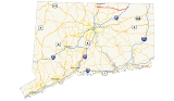
Connecticut Route 190
Encyclopedia
Route 190 is a state route in the northern part of the U.S. state
of Connecticut
. It starts at Route 75 in the town of Suffield
and proceeds eastward across the Connecticut River
through the towns of Enfield
, Somers
, and Stafford
. It ends at Route 171
, in the town of Union
. Route 190 was established in 1932 as a route between the state line at Southwick
and the town of Enfield. The route was later extended eastward to Union but was truncated in the west to Suffield center.
as Mapleton Avenue. The road then bears right onto Thompsonville Road to connect to Route 159
(East Street). After travelling south on Route 159 for 0.6 mile (0.965604 km), it turns eastward again on Hazard Avenue, crossing the Connecticut River
from Suffield into Enfield on the Enfield-Suffield Veterans Bridge
.
 Hazard Avenue is a limited access road from its intersection with Route 159 to just east of the interchange with I-91. Hazard Avenue has an interchange with US 5 just after the Connecticut River crossing, where access is via Frew Terrace (eastbound) and Franklin Street (westbound). Both these streets are unsigned state roads with designations State Road 515 and 514, respectively. About 0.3 mile (0.482802 km) to the east is a cloverleaf interchange
with I-91 (at Exits 47E and 47W). East of I-91, Hazard Avenue continues as a four-lane divided surface road for another 0.6 mile (0.965604 km), passing by the Brookside Plaza strip mall. Route 190 continues east for about four miles (6 km) through the Hazardville
and Scitico sections of Enfield, where it intersects with Routes 192 and 191 along the way. In Scitico, Route 190 passes by another strip mall, the Scitico Shopping Center as it heads east into the town of Somers
.
 On entering Somers, the road becomes known as Main Street, as it goes through the Somersville section of town, where it intersects with Route 186
. After crossing the Scantic River
, Route 190 reaches the town center of Somers, where it meets with Route 83, the main north–south route of the town. Route 190 soon enters the town of Stafford
, where the road changes name to Chestnut Mountain Road. Several miles later, it intersects with Route 30 in the West Stafford section of town, where the road name changes to West Stafford Road. About a mile east of West Stafford, the road splits into two: Route 319
heads in a northeasterly direction heading towards the Stafford town center, while Route 190 heads in a southeasterly direction towards the Stafford Springs section of town. On the way to Stafford Springs, Route 190 becomes concurrent with Route 32 as it runs along West Main Street and Main Street. In the center of Stafford Springs, Route 32 splits off to the south while Route 190 continues east as East Main Street. It soon intersects with Route 19, at which point Route 190 becomes known as Buckley Highway. The route then enters the town of Union
, where it has junctions with Route 89
at its northern terminus and with I-84 about a mile after that (at Exit 73). Route 190 reaches its eastern end at Route 171
in the town center of Union
about 2 miles (3.2 km) east of the I-84 interchange.
) in October 1808. Known as the Woodstock and Somers Turnpike, the road was laid out as a westward continuation of the Woodstock and Thompson Turnpike. It left Woodstock
center as Pulpit Rock Road, then continued west along a portion of modern Route 171 to the village of West Woodstock. From there it went across the northern edge of the towns of Eastford
and Ashford
using now largely abandoned roads through several reservoirs in the area. The alignment picks up again in northern Ashford town as Hillside Road, which leads to modern Route 190 in the southwest corner of Union. The turnpike then follows mostly along modern Route 190 west to Somers center. By 1832, the turnpike company charter was revoked and the road was turned over to the towns it was located in.
In 1922, when state highways were first signed with route numbers in Connecticut, the road connecting the towns of Suffield
and the Thompsonville section of Enfield
was designated as State Highway 303. It used Thompsonville Road in Suffield, then crossed over the now demolished Thompsonville Bridge to reach Main Street in Thompsonville. The Thompsonville Bridge was built in 1892. Most of the portion of modern Route 190 east of US 5, including the portion of the old Woodstock and Somers Turnpike between Somers and Stafford Springs, was also designated as a state highway known as State Highway 105, which ran from Thompsonville to Stafford Springs via Somers center. East of Stafford Springs, modern Route 190 used to be part of State Highway 149, which ran from Stafford Springs to the Massachusetts state line via the town center of Union (along a portion of modern Route 171).
In the 1932 state highway renumbering
, modern Route 190 was created, incorporating old State Highway 303, with a westward extension via the village of West Suffield to the Congamond Notch in the town of Southwick, Massachusetts
. The original Route 190 used modern Route 168 to reach Route 75
then, after a brief overlap with Route 75, it used modern Route 190 to reach the west bank of the Connecticut River. Old State Highway 105 was designated as part of Route 20
, and the Buckley Highway (old State Highway 149) became part of Route 15
in 1932. By 1947, with the opening of the Wilbur Cross Highway
as an undivided four-lane highway, Route 15 was relocated to this new road, Route 20 was extended east to the Wilbur Cross Highway, and Buckley Highway in Union became a town road. In 1961, the Bradley Airport Connector
opened and Route 20 was relocated to use the new road. Route 20 was truncated to end at Exit 40 of I-91, where it ends today. The portion of Route 20 east of the Connecticut River was re-designated as an extension of Route 190, which now ended at Wilbur Cross Highway
(now I-84) in Union. As a result of the Route Reclassification Act of 1963, the Buckley Highway became a state-maintained road and was assigned as part of Route 190.
Route 190 was relocated to a new bridge over the Connecticut River
in January 1967, called the Enfield-Suffield Veterans Bridge
. This bridge was a replacement for the now aging Thompsonville bridge which was deemed unsafe. The approaches to the old Thompsonville Bridge initially became unsigned state roads but were later turned over to the towns after the old bridge was demolished in 1971. Not too long after the relocation, a freeway connection to Interstate 91 was constructed as part of a grander plan for expressways in the Greater Hartford area. In 1973, I-190 was officially designated by the Federal Highway Administration
in Worcester, Massachusetts
. Because Route 190 extended into Massachusetts, this created a numbering conflict. In 1975, the portion of Route 190 west of Route 75 was changed in both states to Route 168. I-190 opened to traffic in 1983.
residents and officials saw the value of reducing traffic along Thompsonville road.
In July 1962, the plan was modified to build an expressway from Route 75
in Suffield to I-91 in Enfield. Route 190, which was to be relocated to a more sooutherly alignment, was to cross under Route 159 at Canal Road.
A cloverleaf
would be built on the west side of Route 159. Funds for this project were appropriated in 1961. Funds to extend Route 190 to Bridge Street would arrive in the future. In April 1963, the scope of the project was pulled back. The projected cost had risen from the original $6.5 million. To keep within that budget, the state planned to work east of Route 159 only, including the bridge and the Interstate 91
interchange. On January 6, 1967, the new bridge opened, and the old Thompsonville Bridge was closed. The opening of the Route 190 expressway was delayed by a strike until later that year.
U.S. state
A U.S. state is any one of the 50 federated states of the United States of America that share sovereignty with the federal government. Because of this shared sovereignty, an American is a citizen both of the federal entity and of his or her state of domicile. Four states use the official title of...
of Connecticut
Connecticut
Connecticut is a state in the New England region of the northeastern United States. It is bordered by Rhode Island to the east, Massachusetts to the north, and the state of New York to the west and the south .Connecticut is named for the Connecticut River, the major U.S. river that approximately...
. It starts at Route 75 in the town of Suffield
Suffield, Connecticut
Suffield is a town in Hartford County, Connecticut, United States. It had once been within the boundaries of Massachusetts. The town is located in the Connecticut River Valley with the town of Enfield neighboring to the east. In 1900, 3,521 people lived in Suffield; and in 1910, 3,841. As of the...
and proceeds eastward across the Connecticut River
Connecticut River
The Connecticut River is the largest and longest river in New England, and also an American Heritage River. It flows roughly south, starting from the Fourth Connecticut Lake in New Hampshire. After flowing through the remaining Connecticut Lakes and Lake Francis, it defines the border between the...
through the towns of Enfield
Enfield, Connecticut
Enfield is a town located in Hartford County, Connecticut, United States. The population was 45,212 at the 2000 census. It sits on the border with Longmeadow, Massachusetts and East Longmeadow, Massachusetts to the north, Somers to the east, East Windsor and Ellington to the south, and the...
, Somers
Somers, Connecticut
Somers is a town in Tolland County, Connecticut, USA. The population was 10,417 at the 2000 census. The town center is listed by the U.S. Census Bureau as a census-designated place...
, and Stafford
Stafford, Connecticut
Stafford is a town in Tolland County, Connecticut, United States, settled in 1719. The population was 11,307 at the 2000 census.-History:The Colonial Town of Stafford began as a rural agricultural community...
. It ends at Route 171
Connecticut Route 171
Route 171 is a state highway in northeastern Connecticut, running from Union to Putnam.-Route description:Route 171 begins at an interchange from I-84 in northern Union and heads south to the town center, then east, south, and southeast into Eastford. It cuts across the northeast corner of...
, in the town of Union
Union, Connecticut
Union is a town in Tolland County, Connecticut, United States. The population was 854 at the 2010 census, making it the least populous town in Connecticut and the second-least populous municipality in Connecticut; only the Borough of Fenwick has fewer people...
. Route 190 was established in 1932 as a route between the state line at Southwick
Southwick, Massachusetts
Southwick is a town in Hampden County, Massachusetts, United States. The population was 9,502 at the 2010 census. It is part of the Springfield, Massachusetts Metropolitan Statistical Area.- History :...
and the town of Enfield. The route was later extended eastward to Union but was truncated in the west to Suffield center.
Route description
Route 190 starts at Route 75, in the town of SuffieldSuffield, Connecticut
Suffield is a town in Hartford County, Connecticut, United States. It had once been within the boundaries of Massachusetts. The town is located in the Connecticut River Valley with the town of Enfield neighboring to the east. In 1900, 3,521 people lived in Suffield; and in 1910, 3,841. As of the...
as Mapleton Avenue. The road then bears right onto Thompsonville Road to connect to Route 159
Route 159 (Connecticut)
Route 159 is a state highway connecting the Hartford and Springfield areas in the U.S. states of Connecticut and Massachusetts. It begins as the northern extension of Main Street in Hartford and proceeds northward along the west bank of the Connecticut River towards Agawam, Massachusetts...
(East Street). After travelling south on Route 159 for 0.6 mile (0.965604 km), it turns eastward again on Hazard Avenue, crossing the Connecticut River
Connecticut River
The Connecticut River is the largest and longest river in New England, and also an American Heritage River. It flows roughly south, starting from the Fourth Connecticut Lake in New Hampshire. After flowing through the remaining Connecticut Lakes and Lake Francis, it defines the border between the...
from Suffield into Enfield on the Enfield-Suffield Veterans Bridge
Enfield-Suffield Veterans Bridge
The Enfield–Suffield Veterans Bridge is a crossing for Route 190 over the Connecticut River, connecting the towns of Enfield, Connecticut and Suffield, Connecticut-External links and references:...
.
Cloverleaf interchange
A cloverleaf interchange is a two-level interchange in which left turns, reverse direction in left-driving regions, are handled by ramp roads...
with I-91 (at Exits 47E and 47W). East of I-91, Hazard Avenue continues as a four-lane divided surface road for another 0.6 mile (0.965604 km), passing by the Brookside Plaza strip mall. Route 190 continues east for about four miles (6 km) through the Hazardville
Hazardville, Connecticut
Hazardville is a section of the town of Enfield, Connecticut, in Hartford County. It is a census-designated place that had a total population of 4,900 as of the 2000 census.-History:...
and Scitico sections of Enfield, where it intersects with Routes 192 and 191 along the way. In Scitico, Route 190 passes by another strip mall, the Scitico Shopping Center as it heads east into the town of Somers
Somers, Connecticut
Somers is a town in Tolland County, Connecticut, USA. The population was 10,417 at the 2000 census. The town center is listed by the U.S. Census Bureau as a census-designated place...
.
Connecticut Route 186
Route 186 is a numbered route in the U.S. states of Connecticut and Massachusetts, serving the southeastern suburbs of Springfield, Massachusetts. The route runs from Route 190 in the Somersville section of the Connecticut town of Somers to the town center of East Longmeadow, Massachusetts...
. After crossing the Scantic River
Scantic River
The Scantic River is a river that flows through the states of Massachusetts and Connecticut and is tributary to the Connecticut River.The Scantic River's tributaries rise in the towns of Hampden, Wilbraham, East Longmeadow and Monson in Massachusetts, and in Stafford and Somers, Connecticut,...
, Route 190 reaches the town center of Somers, where it meets with Route 83, the main north–south route of the town. Route 190 soon enters the town of Stafford
Stafford, Connecticut
Stafford is a town in Tolland County, Connecticut, United States, settled in 1719. The population was 11,307 at the 2000 census.-History:The Colonial Town of Stafford began as a rural agricultural community...
, where the road changes name to Chestnut Mountain Road. Several miles later, it intersects with Route 30 in the West Stafford section of town, where the road name changes to West Stafford Road. About a mile east of West Stafford, the road splits into two: Route 319
Connecticut Route 319
Route 319 is a state highway in northern Connecticut running entirely in Stafford.-Route description:Route 319 begins at an intersection with Route 190 in Stafford and heads east and northeast, crossing Furnace Brook and ending at an intersection with Route 19 in Stafford Hollow...
heads in a northeasterly direction heading towards the Stafford town center, while Route 190 heads in a southeasterly direction towards the Stafford Springs section of town. On the way to Stafford Springs, Route 190 becomes concurrent with Route 32 as it runs along West Main Street and Main Street. In the center of Stafford Springs, Route 32 splits off to the south while Route 190 continues east as East Main Street. It soon intersects with Route 19, at which point Route 190 becomes known as Buckley Highway. The route then enters the town of Union
Union, Connecticut
Union is a town in Tolland County, Connecticut, United States. The population was 854 at the 2010 census, making it the least populous town in Connecticut and the second-least populous municipality in Connecticut; only the Borough of Fenwick has fewer people...
, where it has junctions with Route 89
Connecticut Route 89
Route 89 is a state highway in northeastern Connecticut, running from eastern Mansfield to southern Union. It connectes the villages of Mansfield Center, Warrenville, and Westford...
at its northern terminus and with I-84 about a mile after that (at Exit 73). Route 190 reaches its eastern end at Route 171
Connecticut Route 171
Route 171 is a state highway in northeastern Connecticut, running from Union to Putnam.-Route description:Route 171 begins at an interchange from I-84 in northern Union and heads south to the town center, then east, south, and southeast into Eastford. It cuts across the northeast corner of...
in the town center of Union
Union, Connecticut
Union is a town in Tolland County, Connecticut, United States. The population was 854 at the 2010 census, making it the least populous town in Connecticut and the second-least populous municipality in Connecticut; only the Borough of Fenwick has fewer people...
about 2 miles (3.2 km) east of the I-84 interchange.
History
A portion of modern Route 190 was chartered as a private toll road (or turnpikeToll road
A toll road is a privately or publicly built road for which a driver pays a toll for use. Structures for which tolls are charged include toll bridges and toll tunnels. Non-toll roads are financed using other sources of revenue, most typically fuel tax or general tax funds...
) in October 1808. Known as the Woodstock and Somers Turnpike, the road was laid out as a westward continuation of the Woodstock and Thompson Turnpike. It left Woodstock
Woodstock, Connecticut
Woodstock is a town in Windham County, Connecticut, United States. The population was 7,221 at the 2000 census.-Annual events:*The Woodstock Fair, run by the Woodstock Agricultural Society has been held since 1860. The current President of the Woodstock Fair is Susan Z. Hibbard...
center as Pulpit Rock Road, then continued west along a portion of modern Route 171 to the village of West Woodstock. From there it went across the northern edge of the towns of Eastford
Eastford, Connecticut
Eastford is a town in Windham County, Connecticut, United States. The population was 1,618 at the 2000 census.-Geography:According to the United States Census Bureau, the town has a total area of , of which, of it is land and of it is water....
and Ashford
Ashford, Connecticut
President George Washington, returning from his tour of the country in the fall of 1789, was chagrined to be involuntarily abandoned in the village on a Sunday...
using now largely abandoned roads through several reservoirs in the area. The alignment picks up again in northern Ashford town as Hillside Road, which leads to modern Route 190 in the southwest corner of Union. The turnpike then follows mostly along modern Route 190 west to Somers center. By 1832, the turnpike company charter was revoked and the road was turned over to the towns it was located in.
In 1922, when state highways were first signed with route numbers in Connecticut, the road connecting the towns of Suffield
Suffield, Connecticut
Suffield is a town in Hartford County, Connecticut, United States. It had once been within the boundaries of Massachusetts. The town is located in the Connecticut River Valley with the town of Enfield neighboring to the east. In 1900, 3,521 people lived in Suffield; and in 1910, 3,841. As of the...
and the Thompsonville section of Enfield
Enfield, Connecticut
Enfield is a town located in Hartford County, Connecticut, United States. The population was 45,212 at the 2000 census. It sits on the border with Longmeadow, Massachusetts and East Longmeadow, Massachusetts to the north, Somers to the east, East Windsor and Ellington to the south, and the...
was designated as State Highway 303. It used Thompsonville Road in Suffield, then crossed over the now demolished Thompsonville Bridge to reach Main Street in Thompsonville. The Thompsonville Bridge was built in 1892. Most of the portion of modern Route 190 east of US 5, including the portion of the old Woodstock and Somers Turnpike between Somers and Stafford Springs, was also designated as a state highway known as State Highway 105, which ran from Thompsonville to Stafford Springs via Somers center. East of Stafford Springs, modern Route 190 used to be part of State Highway 149, which ran from Stafford Springs to the Massachusetts state line via the town center of Union (along a portion of modern Route 171).
In the 1932 state highway renumbering
1932 state highway renumbering (Connecticut)
In 1932, the Highway Department of the U.S. state of Connecticut , decided to completely renumber all its state highways. The only exceptions were the U.S. Highways and some of the New England Interstate Routes. Between 1922 and 1932, Connecticut used a state highway numbering system shared with...
, modern Route 190 was created, incorporating old State Highway 303, with a westward extension via the village of West Suffield to the Congamond Notch in the town of Southwick, Massachusetts
Southwick, Massachusetts
Southwick is a town in Hampden County, Massachusetts, United States. The population was 9,502 at the 2010 census. It is part of the Springfield, Massachusetts Metropolitan Statistical Area.- History :...
. The original Route 190 used modern Route 168 to reach Route 75
Route 75 (Connecticut)
Route 75 in the U.S. states of Connecticut and Massachusetts is a scenic route connecting the Hartford and Springfield areas. The route begins at Route 159 in the town of Windsor, Connecticut and ends at the junction of Route 159 and Route 147 in the city of Agawam, Massachusetts.The route...
then, after a brief overlap with Route 75, it used modern Route 190 to reach the west bank of the Connecticut River. Old State Highway 105 was designated as part of Route 20
Route 20 (Connecticut)
Route 20 is a state highway in the U.S. state of Connecticut. It extends from Route 8 in rural Winchester to I-91 in Windsor. Route 20 consists of two distinct sections: a long, winding, scenic rural road, and a section of the freeway linking I-91 to Bradley International...
, and the Buckley Highway (old State Highway 149) became part of Route 15
Route 15 (Connecticut)
Route 15 is a state highway in the U.S. state of Connecticut that runs from a connection with New York's Hutchinson River Parkway in Greenwich, Connecticut to its northern terminus intersecting with Interstate 84 in East Hartford, Connecticut...
in 1932. By 1947, with the opening of the Wilbur Cross Highway
Wilbur Cross Highway
The Wilbur Cross Highway is the designation for the portion of old Route 15 from Wethersfield in Connecticut, through Hartford and Manchester, to the Massachusetts Turnpike in Sturbridge, Massachusetts. The highway was built in the 1940s before the Interstate Highway era...
as an undivided four-lane highway, Route 15 was relocated to this new road, Route 20 was extended east to the Wilbur Cross Highway, and Buckley Highway in Union became a town road. In 1961, the Bradley Airport Connector
Bradley Airport Connector
The Bradley Airport Connector is a expressway built to connect Bradley International Airport to Interstate 91 in Windsor, Connecticut. It begins at Exit 40 of I-91 and heads west as Route 20 roughly along the town line between Windsor and Windsor Locks...
opened and Route 20 was relocated to use the new road. Route 20 was truncated to end at Exit 40 of I-91, where it ends today. The portion of Route 20 east of the Connecticut River was re-designated as an extension of Route 190, which now ended at Wilbur Cross Highway
Wilbur Cross Highway
The Wilbur Cross Highway is the designation for the portion of old Route 15 from Wethersfield in Connecticut, through Hartford and Manchester, to the Massachusetts Turnpike in Sturbridge, Massachusetts. The highway was built in the 1940s before the Interstate Highway era...
(now I-84) in Union. As a result of the Route Reclassification Act of 1963, the Buckley Highway became a state-maintained road and was assigned as part of Route 190.
Route 190 was relocated to a new bridge over the Connecticut River
Connecticut River
The Connecticut River is the largest and longest river in New England, and also an American Heritage River. It flows roughly south, starting from the Fourth Connecticut Lake in New Hampshire. After flowing through the remaining Connecticut Lakes and Lake Francis, it defines the border between the...
in January 1967, called the Enfield-Suffield Veterans Bridge
Enfield-Suffield Veterans Bridge
The Enfield–Suffield Veterans Bridge is a crossing for Route 190 over the Connecticut River, connecting the towns of Enfield, Connecticut and Suffield, Connecticut-External links and references:...
. This bridge was a replacement for the now aging Thompsonville bridge which was deemed unsafe. The approaches to the old Thompsonville Bridge initially became unsigned state roads but were later turned over to the towns after the old bridge was demolished in 1971. Not too long after the relocation, a freeway connection to Interstate 91 was constructed as part of a grander plan for expressways in the Greater Hartford area. In 1973, I-190 was officially designated by the Federal Highway Administration
Federal Highway Administration
The Federal Highway Administration is a division of the United States Department of Transportation that specializes in highway transportation. The agency's major activities are grouped into two "programs," the Federal-aid Highway Program and the Federal Lands Highway Program...
in Worcester, Massachusetts
Worcester, Massachusetts
Worcester is a city and the county seat of Worcester County, Massachusetts, United States. Named after Worcester, England, as of the 2010 Census the city's population is 181,045, making it the second largest city in New England after Boston....
. Because Route 190 extended into Massachusetts, this created a numbering conflict. In 1975, the portion of Route 190 west of Route 75 was changed in both states to Route 168. I-190 opened to traffic in 1983.
Expressway plans
In November 1958, the state of Connecticut developed a plan to replace the aging Thompsonville Bridge and to relocate Route 190 to the new bridge. There was some opposition to the plan, though other SuffieldSuffield, Connecticut
Suffield is a town in Hartford County, Connecticut, United States. It had once been within the boundaries of Massachusetts. The town is located in the Connecticut River Valley with the town of Enfield neighboring to the east. In 1900, 3,521 people lived in Suffield; and in 1910, 3,841. As of the...
residents and officials saw the value of reducing traffic along Thompsonville road.
In July 1962, the plan was modified to build an expressway from Route 75
Route 75 (Connecticut)
Route 75 in the U.S. states of Connecticut and Massachusetts is a scenic route connecting the Hartford and Springfield areas. The route begins at Route 159 in the town of Windsor, Connecticut and ends at the junction of Route 159 and Route 147 in the city of Agawam, Massachusetts.The route...
in Suffield to I-91 in Enfield. Route 190, which was to be relocated to a more sooutherly alignment, was to cross under Route 159 at Canal Road.
A cloverleaf
Cloverleaf
-Places:*Cloverleaf, Louisville, Kentucky, a neighborhood*Cloverleaf, Texas, a suburb of Houston*Cloverleaf Local School District in southern Medina County, Ohio-Science and technology:*A representation of the chemical structure of a transfer RNA molecule...
would be built on the west side of Route 159. Funds for this project were appropriated in 1961. Funds to extend Route 190 to Bridge Street would arrive in the future. In April 1963, the scope of the project was pulled back. The projected cost had risen from the original $6.5 million. To keep within that budget, the state planned to work east of Route 159 only, including the bridge and the Interstate 91
Interstate 91
Interstate 91 is an Interstate Highway in the New England region of the United States. It provides the primary north–south thoroughfare in the western part of New England...
interchange. On January 6, 1967, the new bridge opened, and the old Thompsonville Bridge was closed. The opening of the Route 190 expressway was delayed by a strike until later that year.
Special designations
The segment of Route 190 in Suffield, from Route 75 to Route 159, is also known as the "Corporal Stephen R. Bixler Memorial Highway", named for a Suffield native who died in the Iraq War.Junction list
| Location | Mile | Roads intersected | Notes |
|---|
External links
- Route 190 Expressway Historic Overview from nycroads.com