

Southwick, Massachusetts
Encyclopedia
Southwick is a town
in Hampden County
, Massachusetts
, United States
. The population was 9,502 at the 2010 census. It is part of the Springfield, Massachusetts
Metropolitan Statistical Area
.
s.
, discovered the area and settled Southwick. It became a farming community
, defined as the Southern (South-) village (-wick) part the town of Westfield
, Massachusetts
. Early on, it was nicknamed Poverty Plains because the land was thought to be infertile and its first residential home
was built by Samuel Fowler and his wife Naomi Noble on College Highway (US Rts. 10 and 202), about a quarter mile north of the current town center.
In colonial times, church attendance was not mandatory. The 800 Christian
residents of Southwick in the 1760-70s were required to travel to Westfield
to congregate. Only by establishing their own church society [community] could they establish their own parish, as they desired. On November 7, 1770, Southwick was incorporated as a separate district of Westfield. The area of Southwick became somewhat smaller in 1770. The southernmost portion of Southwick joined Suffield
, Connecticut
, as the result of a simultaneous secession of citizens in that part of the village.
.
and Hampshire and Hampden Canal
was built to link New Haven, Connecticut, to Northampton
, Massachusetts, through Southwick. Irish immigrants came to the area to labor on this project. Developers spoke of Southwick's potential, calling it the "Port of the World". Farmers conflicted with the prospect that the canal would drain the Lakes. It was reported that citizens would kick in the banks to damage the canal. Traces of the canal can still be found in the Great Brook and Congamond Lakes area. Due to winter freezings, summer drought and wildlife impact (beaver dams ...etc.), the canal was phased out in favor of the railroad.
Completed in the late 1840s, the New York/New Haven Railroad (New Haven/Northampton) was built alongside the canal (more or less) as a revolutionary mode for travel to and through Southwick. With the railroad came the ice industry and the tourist resorts around the Congamond Lakes, (which were named 'Wenekeiamaug' by the previously existing Indian tribe). Several ornate hotels and dance halls were built as well as a small amusement park. During the Industrial era, summer vacationers and daytrippers would escape the hot and dirty cities connected by the Northeast Railroad Corridor from New York City
, Albany
, Boston
, Worcester
, Hartford and especially Springfield
. There was a special stop near the Lakes where visitors would disembark to swim and/or pile into canopied pleasure boats.
During the 1st and 2nd World Wars, trains loaded with soldiers would also pass through town. It has been noted that local girls would gather letters thrown by the soldiers from the train - and forward them to the intended recipients at the Post Office. The last train to pass along these tracks was around 1976. As of 2008, the old rail way is in the process of being converted into a railtrail connecting to Granby, Connecticut.
All of Southwick's grand hotels and ornate train stations have since been torn down. Babbs Roller Skating Rink (on the Suffield, CT side of Congamond Lakes) is all that remains of the amusement park.
Collected from the Springfield lakes, stored in massive ice houses as ice (blocks) and delivered via railway for food storage from New York City
to Boston
before electric refrigerators were available for public purchase.
) at Granville Road (Massachusetts Route 57
) and Depot Street there was a "Town Square". Basic markets of trade, communication, medical and grooming services, barns and utilitarian outbuildings served the traveling public and their horses as well as Southwick's own. A growing collection of homes and civic buildings reflected the period in which they were built. A space for civic gatherings formed. Notably, a Village Meeting Hall was built on the west side of College Highway across from where the Congregational church still stands. The library found its place on the corner of College Highway and Granville Road and so did the "Southwick Hotel". It was a modest and hopeful beginning for a village.
As horse travel lost out to the automobile, blacksmith
stalls were replaced with gas stations. Further business expanded away from the original Town Square. Family stores competed with an Atlantic & Pacific Tea Company located in the heart of the village. A telegram and postal office separated into a Bell Telephone Company
office, complete with its own staff of operators and relocated to newer facilities just north of the center. Southwick's many one-room-school-houses were replaced, in use, by the Consolidated School built in 1928 directly south of the center. A police and firestation was built just east of the center. Until the mid 1970s, anyone could walk from the Town Center to clothing stores such as Smith's Department Store & Adams Shoes, food stores such as Jones Market & Cantell's, doctor's offices, barber shops, banks such as Woronoco Savings and Third National, and two family owned drugstores; Southwick Pharmacy & Community Drugs complete with their own lunch counters. It truly was a "close knit" community.
Modernization spurred further change and growth outward from Southwick Center. Business and civic endeavors sought more space for inventory and parking. A few of the historically significant buildings, such as the aforementioned Meeting Hall, have been torn down or relocated to such tourist attractions as Old Sturbridge Village
and the Eastern States Exposition to serve as museums of our region's rich history.
Today, the original Town Square still has the Congregational Church, a gift shop and the Inn. All are still in use and have retained their original appearance. Concerned citizens strive to preserve Southwick's heritage. Hopefully other historic buildings, such as the original Town Library will also be preserved and honored in the place they stand, or relocated to an area where the building can be put to a constructive use.
 According to the United States Census Bureau
, the town has a total area of 31.7 square miles (82.1 km²), of which 31.0 square miles (80.2 km²) is land and 0.8 square mile (1.9 km²) (2.37%) is water.
As described above, Southwick is the southernmost town in western Massachusetts, as a result of a "jog" in the Massachusetts-Connecticut border. (See History of Massachusetts
) Southwick is bordered on the north by Westfield, on the east by Agawam and Suffield, CT, on the south by Suffield, CT and Granby, CT, and on the west by Granby, CT and Granville.
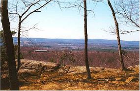
The 110-mile Metacomet-Monadnock Trail
(a hiking trail) passes over Provin Mountain
, a trap rock
ridge and cliffline that forms the eastern border of Southwick. Provin Mountain is part of the Metacomet Ridge
, a mountainous trap rock ridgeline that stretches from Long Island Sound
to near the Vermont
border.
of 2000, there were 8,835 people, 3,318 households, and 2,418 families residing in the town. The population density
was 285.4 people per square mile (110.2/km²). There were 3,533 housing units at an average density of 114.1 per square mile (44.1/km²). The racial makeup of the town was 97.41% White, 0.51% African American, 0.20% Native American, 0.37% Asian, 0.01% Pacific Islander, 0.34% from other races
, and 1.15% from two or more races. Hispanic or Latino of any race were 1.72% of the population.
There were 3,318 households out of which 36.6% had children under the age of 18 living with them, 60.0% were married couples
living together, 8.3% had a female householder with no husband present, and 27.1% were non-families. 21.9% of all households were made up of individuals and 9.9% had someone living alone who was 65 years of age or older. The average household size was 2.66 and the average family size was 3.13.
In the town the population was spread out with 26.5% under the age of 18, 6.3% from 18 to 24, 32.2% from 25 to 44, 23.2% from 45 to 64, and 11.7% who were 65 years of age or older. The median age was 38 years. For every 100 females there were 100.4 males. For every 100 females age 18 and over, there were 98.2 males.
The median income for a household in the town was $52,296, and the median income for a family was $64,456. Males had a median income of $41,863 versus $30,889 for females. The per capita income
for the town was $21,756. About 3.8% of families and 6.1% of the population were below the poverty line, including 6.3% of those under age 18 and 9.8% of those age 65 or over.
and Tolland
, all headed by Superintendent
John D. Barry, Ed.D. The Southwick-Tolland Early Childhood Center serves Southwick and Tolland's preschoolers. The Woodland Elementary School serves Southwick and Tolland's kindergarten through fourth grade students. The Powder Mill Middle School serves Southwick and Tolland's fifth through eight graders. The Southwick-Tolland Regional High School
serves Southwick, Tolland, and Granville's ninth through twelfth graders. In late 2011, the towns of Southwick, Granville and Tolland voted to admit Granville into the Southwick Tolland Regional School District. This vote was also a show of support for a purported $42M school renovation and construction project that is slated to be voted upon by the member towns in early 2012.
The Library Board of Trustees consists of:
New England town
The New England town is the basic unit of local government in each of the six New England states. Without a direct counterpart in most other U.S. states, New England towns are conceptually similar to civil townships in other states, but are incorporated, possessing powers like cities in other...
in Hampden County
Hampden County, Massachusetts
-Demographics:As of the census of 2004, there were 461,228 people, 175,288 households, and 115,690 families residing in the county. The population density was 738 people per square mile . There were 185,876 housing units at an average density of 301 per square mile...
, Massachusetts
Massachusetts
The Commonwealth of Massachusetts is a state in the New England region of the northeastern United States of America. It is bordered by Rhode Island and Connecticut to the south, New York to the west, and Vermont and New Hampshire to the north; at its east lies the Atlantic Ocean. As of the 2010...
, United States
United States
The United States of America is a federal constitutional republic comprising fifty states and a federal district...
. The population was 9,502 at the 2010 census. It is part of the Springfield, Massachusetts
Springfield, Massachusetts
Springfield is the most populous city in Western New England, and the seat of Hampden County, Massachusetts, United States. Springfield sits on the eastern bank of the Connecticut River near its confluence with three rivers; the western Westfield River, the eastern Chicopee River, and the eastern...
Metropolitan Statistical Area
Springfield, Massachusetts metropolitan area
The Springfield Metropolitan Area is a region that is socio-economically and culturally tied to the City of Springfield, Massachusetts. The U.S. Office of Management and Budget defines the Springfield metropolitan statistical area as consisting of three counties in Western Massachusetts. As of...
.
History
Southwick was originally inhabited by either the Matitacooke, Mayawaug and Woronoake tribes of Native AmericanNative Americans in the United States
Native Americans in the United States are the indigenous peoples in North America within the boundaries of the present-day continental United States, parts of Alaska, and the island state of Hawaii. They are composed of numerous, distinct tribes, states, and ethnic groups, many of which survive as...
s.
Early history
In the mid-17th century, Pioneering English explorers moving up the Connecticut River Valley, seeking fertile farmlands and gameGame
A game is structured playing, usually undertaken for enjoyment and sometimes used as an educational tool. Games are distinct from work, which is usually carried out for remuneration, and from art, which is more often an expression of aesthetic or ideological elements...
, discovered the area and settled Southwick. It became a farming community
Community
The term community has two distinct meanings:*a group of interacting people, possibly living in close proximity, and often refers to a group that shares some common values, and is attributed with social cohesion within a shared geographical location, generally in social units larger than a household...
, defined as the Southern (South-) village (-wick) part the town of Westfield
Westfield, Massachusetts
Westfield is a city in Hampden County, in the Pioneer Valley of western Massachusetts, United States. It is part of the Springfield, Massachusetts Metropolitan Statistical Area. The population was 41,094 at the 2010 census. The ZIP Code is 01085 for homes and businesses, 01086 for Westfield State...
, Massachusetts
Massachusetts
The Commonwealth of Massachusetts is a state in the New England region of the northeastern United States of America. It is bordered by Rhode Island and Connecticut to the south, New York to the west, and Vermont and New Hampshire to the north; at its east lies the Atlantic Ocean. As of the 2010...
. Early on, it was nicknamed Poverty Plains because the land was thought to be infertile and its first residential home
Home
A home is a place of residence or refuge. When it refers to a building, it is usually a place in which an individual or a family can rest and store personal property. Most modern-day households contain sanitary facilities and a means of preparing food. Animals have their own homes as well, either...
was built by Samuel Fowler and his wife Naomi Noble on College Highway (US Rts. 10 and 202), about a quarter mile north of the current town center.
In colonial times, church attendance was not mandatory. The 800 Christian
Christian
A Christian is a person who adheres to Christianity, an Abrahamic, monotheistic religion based on the life and teachings of Jesus of Nazareth as recorded in the Canonical gospels and the letters of the New Testament...
residents of Southwick in the 1760-70s were required to travel to Westfield
Westfield, Massachusetts
Westfield is a city in Hampden County, in the Pioneer Valley of western Massachusetts, United States. It is part of the Springfield, Massachusetts Metropolitan Statistical Area. The population was 41,094 at the 2010 census. The ZIP Code is 01085 for homes and businesses, 01086 for Westfield State...
to congregate. Only by establishing their own church society [community] could they establish their own parish, as they desired. On November 7, 1770, Southwick was incorporated as a separate district of Westfield. The area of Southwick became somewhat smaller in 1770. The southernmost portion of Southwick joined Suffield
Suffield, Connecticut
Suffield is a town in Hartford County, Connecticut, United States. It had once been within the boundaries of Massachusetts. The town is located in the Connecticut River Valley with the town of Enfield neighboring to the east. In 1900, 3,521 people lived in Suffield; and in 1910, 3,841. As of the...
, Connecticut
Connecticut
Connecticut is a state in the New England region of the northeastern United States. It is bordered by Rhode Island to the east, Massachusetts to the north, and the state of New York to the west and the south .Connecticut is named for the Connecticut River, the major U.S. river that approximately...
, as the result of a simultaneous secession of citizens in that part of the village.
Independence
Ultimately, Southwick became a fully independent town in 1775. The town remained divided until 1793, when Massachusetts claimed the area (known as the "jog"). A border dispute continued until 1804, when the current boundary was established through a compromise between Connecticut and Massachusetts. As a result of this border resolution, Southwick is the southernmost town in western MassachusettsWestern Massachusetts
Western Massachusetts is a loosely defined geographical region of the U.S. state of Massachusetts which contains the Berkshires, the Pioneer Valley, and some or all of the Swift River Valley. The region is always considered to include Berkshire, Franklin, Hampshire, and Hampden counties, and the...
.
Early 1800s
In the early 19th century, the Farmington CanalFarmington Canal
The Farmington Canal, also known as the New Haven and Northampton Canal, was a major private canal built in the early 19th century to provide water transportation from New Haven into the interior of Connecticut, Massachusetts and beyond. Its Massachusetts segment was known as the Hampshire and...
and Hampshire and Hampden Canal
Hampshire and Hampden Canal
The Hampshire and Hampden Canal was the Massachusetts segment of an canal that once connected New Haven, Connecticut to the Connecticut River north of Northampton, Massachusetts...
was built to link New Haven, Connecticut, to Northampton
Northampton
Northampton is a large market town and local government district in the East Midlands region of England. Situated about north-west of London and around south-east of Birmingham, Northampton lies on the River Nene and is the county town of Northamptonshire. The demonym of Northampton is...
, Massachusetts, through Southwick. Irish immigrants came to the area to labor on this project. Developers spoke of Southwick's potential, calling it the "Port of the World". Farmers conflicted with the prospect that the canal would drain the Lakes. It was reported that citizens would kick in the banks to damage the canal. Traces of the canal can still be found in the Great Brook and Congamond Lakes area. Due to winter freezings, summer drought and wildlife impact (beaver dams ...etc.), the canal was phased out in favor of the railroad.
Completed in the late 1840s, the New York/New Haven Railroad (New Haven/Northampton) was built alongside the canal (more or less) as a revolutionary mode for travel to and through Southwick. With the railroad came the ice industry and the tourist resorts around the Congamond Lakes, (which were named 'Wenekeiamaug' by the previously existing Indian tribe). Several ornate hotels and dance halls were built as well as a small amusement park. During the Industrial era, summer vacationers and daytrippers would escape the hot and dirty cities connected by the Northeast Railroad Corridor from New York City
New York City
New York is the most populous city in the United States and the center of the New York Metropolitan Area, one of the most populous metropolitan areas in the world. New York exerts a significant impact upon global commerce, finance, media, art, fashion, research, technology, education, and...
, Albany
Albany, New York
Albany is the capital city of the U.S. state of New York, the seat of Albany County, and the central city of New York's Capital District. Roughly north of New York City, Albany sits on the west bank of the Hudson River, about south of its confluence with the Mohawk River...
, Boston
Boston
Boston is the capital of and largest city in Massachusetts, and is one of the oldest cities in the United States. The largest city in New England, Boston is regarded as the unofficial "Capital of New England" for its economic and cultural impact on the entire New England region. The city proper had...
, Worcester
Worcester, Massachusetts
Worcester is a city and the county seat of Worcester County, Massachusetts, United States. Named after Worcester, England, as of the 2010 Census the city's population is 181,045, making it the second largest city in New England after Boston....
, Hartford and especially Springfield
Springfield, Massachusetts
Springfield is the most populous city in Western New England, and the seat of Hampden County, Massachusetts, United States. Springfield sits on the eastern bank of the Connecticut River near its confluence with three rivers; the western Westfield River, the eastern Chicopee River, and the eastern...
. There was a special stop near the Lakes where visitors would disembark to swim and/or pile into canopied pleasure boats.
During the 1st and 2nd World Wars, trains loaded with soldiers would also pass through town. It has been noted that local girls would gather letters thrown by the soldiers from the train - and forward them to the intended recipients at the Post Office. The last train to pass along these tracks was around 1976. As of 2008, the old rail way is in the process of being converted into a railtrail connecting to Granby, Connecticut.
All of Southwick's grand hotels and ornate train stations have since been torn down. Babbs Roller Skating Rink (on the Suffield, CT side of Congamond Lakes) is all that remains of the amusement park.
Tobacco farming
The fertile soils in the farmlands of Southwick grew tobacco as a lucrative export until recent years.Collected from the Springfield lakes, stored in massive ice houses as ice (blocks) and delivered via railway for food storage from New York City
New York City
New York is the most populous city in the United States and the center of the New York Metropolitan Area, one of the most populous metropolitan areas in the world. New York exerts a significant impact upon global commerce, finance, media, art, fashion, research, technology, education, and...
to Boston
Boston
Boston is the capital of and largest city in Massachusetts, and is one of the oldest cities in the United States. The largest city in New England, Boston is regarded as the unofficial "Capital of New England" for its economic and cultural impact on the entire New England region. The city proper had...
before electric refrigerators were available for public purchase.
Town Center
The original Town Center was located adjacent the Old Cemetery on College Highway at Klaus Anderson Road. With the town border being re-defined, the townspeople also once considered the current Gillette's Corner (where the McDonalds and Big Y Market currently sits) as the center. Commerce and practicality led to the development of the current Town Center, as seen today, in a group of Colonial and Greek Revival buildings, including the landmark Congregational Church and Town Square (at the intersection of Granville Road, Depot Street, and College Highway).Remains of the original Town Square
At the busy intersection of College Highway (U.S. Route 202U.S. Route 202
U.S. Route 202 is a highway stretching from Delaware to Maine, also passing through the states of Pennsylvania, New Jersey, New York, Connecticut, Massachusetts, and New Hampshire....
) at Granville Road (Massachusetts Route 57
Massachusetts Route 57
Route 57 is an east–west Massachusetts state route that runs from Monterey to Agawam. The eastern 5.0 miles in Agawam is a freeway that runs from Route 187 to the route's eastern terminus at U.S. Route 5.- Route description :...
) and Depot Street there was a "Town Square". Basic markets of trade, communication, medical and grooming services, barns and utilitarian outbuildings served the traveling public and their horses as well as Southwick's own. A growing collection of homes and civic buildings reflected the period in which they were built. A space for civic gatherings formed. Notably, a Village Meeting Hall was built on the west side of College Highway across from where the Congregational church still stands. The library found its place on the corner of College Highway and Granville Road and so did the "Southwick Hotel". It was a modest and hopeful beginning for a village.
As horse travel lost out to the automobile, blacksmith
Blacksmith
A blacksmith is a person who creates objects from wrought iron or steel by forging the metal; that is, by using tools to hammer, bend, and cut...
stalls were replaced with gas stations. Further business expanded away from the original Town Square. Family stores competed with an Atlantic & Pacific Tea Company located in the heart of the village. A telegram and postal office separated into a Bell Telephone Company
Bell Telephone Company
The Bell Telephone Company, a common law joint stock company, was organized in Boston, Massachusetts on July 9, 1877 by Alexander Graham Bell's father-in-law Gardiner Greene Hubbard, who also helped organize a sister company — the New England Telephone and Telegraph Company...
office, complete with its own staff of operators and relocated to newer facilities just north of the center. Southwick's many one-room-school-houses were replaced, in use, by the Consolidated School built in 1928 directly south of the center. A police and firestation was built just east of the center. Until the mid 1970s, anyone could walk from the Town Center to clothing stores such as Smith's Department Store & Adams Shoes, food stores such as Jones Market & Cantell's, doctor's offices, barber shops, banks such as Woronoco Savings and Third National, and two family owned drugstores; Southwick Pharmacy & Community Drugs complete with their own lunch counters. It truly was a "close knit" community.
Modernization spurred further change and growth outward from Southwick Center. Business and civic endeavors sought more space for inventory and parking. A few of the historically significant buildings, such as the aforementioned Meeting Hall, have been torn down or relocated to such tourist attractions as Old Sturbridge Village
Old Sturbridge Village
Old Sturbridge Village is a living museum located in Sturbridge, Massachusetts, in the United States, which re-creates life in rural New England during the 1790s through 1830s. It is the largest living museum in New England, covering more than 200 acres . The Village includes 59 antique...
and the Eastern States Exposition to serve as museums of our region's rich history.
Today, the original Town Square still has the Congregational Church, a gift shop and the Inn. All are still in use and have retained their original appearance. Concerned citizens strive to preserve Southwick's heritage. Hopefully other historic buildings, such as the original Town Library will also be preserved and honored in the place they stand, or relocated to an area where the building can be put to a constructive use.
Geography
United States Census Bureau
The United States Census Bureau is the government agency that is responsible for the United States Census. It also gathers other national demographic and economic data...
, the town has a total area of 31.7 square miles (82.1 km²), of which 31.0 square miles (80.2 km²) is land and 0.8 square mile (1.9 km²) (2.37%) is water.
As described above, Southwick is the southernmost town in western Massachusetts, as a result of a "jog" in the Massachusetts-Connecticut border. (See History of Massachusetts
History of Massachusetts
Massachusetts was first colonized by principally English Europeans in the early 17th century, and became the Commonwealth of Massachusetts in the 18th century. Prior to English colonization of the area, it was inhabited by a variety of mainly Algonquian-speaking indigenous tribes...
) Southwick is bordered on the north by Westfield, on the east by Agawam and Suffield, CT, on the south by Suffield, CT and Granby, CT, and on the west by Granby, CT and Granville.
The 110-mile Metacomet-Monadnock Trail
Metacomet-Monadnock Trail
The Metacomet-Monadnock Trail is a hiking trail that traverses the Metacomet Ridge of the Pioneer Valley region of Massachusetts and the central uplands of Massachusetts and southern New Hampshire...
(a hiking trail) passes over Provin Mountain
Provin Mountain
Provin Mountain is a very narrow traprock mountain ridge located in the Connecticut River Valley of Massachusetts. It is part of the Metacomet Ridge which extends from Long Island Sound near New Haven, Connecticut, north through the Connecticut River Valley of Massachusetts to the Vermont border...
, a trap rock
Trap rock
Trap rock is a form of igneous rock that tends to form polygonal vertical fractures, most typically hexagonal, but also four to eight sided. The fracture pattern forms when magma of suitable chemical composition intrudes as a sill or extrudes as a thick lava flow, and slowly cools.Because of the...
ridge and cliffline that forms the eastern border of Southwick. Provin Mountain is part of the Metacomet Ridge
Metacomet Ridge
The Metacomet Ridge, Metacomet Ridge Mountains, or Metacomet Range of southern New England, United States, is a narrow and steep fault-block mountain ridge known for its extensive cliff faces, scenic vistas, microclimate ecosystems, and communities of plants considered rare or endangered...
, a mountainous trap rock ridgeline that stretches from Long Island Sound
Long Island Sound
Long Island Sound is an estuary of the Atlantic Ocean, located in the United States between Connecticut to the north and Long Island, New York to the south. The mouth of the Connecticut River at Old Saybrook, Connecticut, empties into the sound. On its western end the sound is bounded by the Bronx...
to near the Vermont
Vermont
Vermont is a state in the New England region of the northeastern United States of America. The state ranks 43rd in land area, , and 45th in total area. Its population according to the 2010 census, 630,337, is the second smallest in the country, larger only than Wyoming. It is the only New England...
border.
Demographics
As of the censusCensus
A census is the procedure of systematically acquiring and recording information about the members of a given population. It is a regularly occurring and official count of a particular population. The term is used mostly in connection with national population and housing censuses; other common...
of 2000, there were 8,835 people, 3,318 households, and 2,418 families residing in the town. The population density
Population density
Population density is a measurement of population per unit area or unit volume. It is frequently applied to living organisms, and particularly to humans...
was 285.4 people per square mile (110.2/km²). There were 3,533 housing units at an average density of 114.1 per square mile (44.1/km²). The racial makeup of the town was 97.41% White, 0.51% African American, 0.20% Native American, 0.37% Asian, 0.01% Pacific Islander, 0.34% from other races
Race (United States Census)
Race and ethnicity in the United States Census, as defined by the Federal Office of Management and Budget and the United States Census Bureau, are self-identification data items in which residents choose the race or races with which they most closely identify, and indicate whether or not they are...
, and 1.15% from two or more races. Hispanic or Latino of any race were 1.72% of the population.
There were 3,318 households out of which 36.6% had children under the age of 18 living with them, 60.0% were married couples
Marriage
Marriage is a social union or legal contract between people that creates kinship. It is an institution in which interpersonal relationships, usually intimate and sexual, are acknowledged in a variety of ways, depending on the culture or subculture in which it is found...
living together, 8.3% had a female householder with no husband present, and 27.1% were non-families. 21.9% of all households were made up of individuals and 9.9% had someone living alone who was 65 years of age or older. The average household size was 2.66 and the average family size was 3.13.
In the town the population was spread out with 26.5% under the age of 18, 6.3% from 18 to 24, 32.2% from 25 to 44, 23.2% from 45 to 64, and 11.7% who were 65 years of age or older. The median age was 38 years. For every 100 females there were 100.4 males. For every 100 females age 18 and over, there were 98.2 males.
The median income for a household in the town was $52,296, and the median income for a family was $64,456. Males had a median income of $41,863 versus $30,889 for females. The per capita income
Per capita income
Per capita income or income per person is a measure of mean income within an economic aggregate, such as a country or city. It is calculated by taking a measure of all sources of income in the aggregate and dividing it by the total population...
for the town was $21,756. About 3.8% of families and 6.1% of the population were below the poverty line, including 6.3% of those under age 18 and 9.8% of those age 65 or over.
Education
Southwick has four schools that serve the towns of Southwick, GranvilleGranville, Massachusetts
Granville is a town in Hampden County, Massachusetts, United States. The population was 1,566 at the 2010 census. It is part of the Springfield, Massachusetts Metropolitan Statistical Area.- History and Description :...
and Tolland
Tolland, Massachusetts
Tolland is a town in Hampden County, Massachusetts, United States. The population was 485 at the 2010 census, making it the smallest town in Hampden County by population. It is part of the Springfield, Massachusetts Metropolitan Statistical Area. Tolland formerly had a popular "Black Fly Day"...
, all headed by Superintendent
Superintendent (education)
In education in the United States, a superintendent is an individual who has executive oversight and administration rights, usually within an educational entity or organization....
John D. Barry, Ed.D. The Southwick-Tolland Early Childhood Center serves Southwick and Tolland's preschoolers. The Woodland Elementary School serves Southwick and Tolland's kindergarten through fourth grade students. The Powder Mill Middle School serves Southwick and Tolland's fifth through eight graders. The Southwick-Tolland Regional High School
Southwick-Tolland Regional high school
Southwick-Tolland Regional High School is a public high school serving grades 9-12 in Southwick, Massachusetts, United States. It is part of the Southwick-Tolland Regional School District.-Performance:...
serves Southwick, Tolland, and Granville's ninth through twelfth graders. In late 2011, the towns of Southwick, Granville and Tolland voted to admit Granville into the Southwick Tolland Regional School District. This vote was also a show of support for a purported $42M school renovation and construction project that is slated to be voted upon by the member towns in early 2012.
Online Media
Macaroni Kid Westfield-Southwick EditionTV Media
- NBCNBCThe National Broadcasting Company is an American commercial broadcasting television network and former radio network headquartered in the GE Building in New York City's Rockefeller Center with additional major offices near Los Angeles and in Chicago...
- WWLPWWLPWWLP is the NBC-affiliated television station for the Pioneer Valley of Western Massachusetts that is licensed to Springfield. It broadcasts a high definition digital signal on VHF channel 11 from a transmitter on Provin Mountain in the Feeding Hills section of Agawam. The station can also be seen... - CBSCBSCBS Broadcasting Inc. is a major US commercial broadcasting television network, which started as a radio network. The name is derived from the initials of the network's former name, Columbia Broadcasting System. The network is sometimes referred to as the "Eye Network" in reference to the shape of...
- WSHMWSHM-LPWSHM-LD is the CBS-affiliated television station for the Pioneer Valley of Western Massachusetts. Licensed to Springfield, it broadcasts a low-powered high definition digital signal on UHF channel 21 from a transmitter shared with low-powered Retro Television Network affiliate WTXX-LP on Ridge... - ABCAmerican Broadcasting CompanyThe American Broadcasting Company is an American commercial broadcasting television network. Created in 1943 from the former NBC Blue radio network, ABC is owned by The Walt Disney Company and is part of Disney-ABC Television Group. Its first broadcast on television was in 1948...
- WGGBWGGB-TVWGGB-TV is the ABC-affiliated television station for the Pioneer Valley of Western Massachusetts licensed to Springfield. It broadcasts a high definition digital signal on UHF channel 40 from a transmitter on Mount Tom in Holyoke. The station can also be seen on Charter and Comcast channel 4...
Newspaper Media
- Southwick-Suffield News (Weekly)
- The Republican (Daily)
- Westfield Evening News (Daily)
- Saturday News (Saturday)
Board of Selectmen
- Arthur Pinell, Chairman
- David A. St. Pierre, Vice-Chairman
- Russell Fox, Selectman
School Committee
- Theodore Locke, Chairman
- James L. Vincent, Secretary
- George LeBlanc
- Charles R. Condron
- Jeffery T. Houle
- Elizabeth Magni
Library Board of Trustees
The Southwick Free Public Library was established in 1891. In fiscal year 2008, the town of Southwick spent 2.03% ($316,544) of its budget on its public library—some $33 per person.The Library Board of Trustees consists of:
- Debbie Randzio
- Karen Contois
- Nancy M. Zdun
- Carol Geryk
- Michael J. McMahon
- Nancy K, Stenberg
Planning Board
- Doug Moglin, Chairman
- Roz Terry, Vice-Chair
- Joe Deedy
- Robert Johnson
- Richard Utzinger
- T.J. Welch, Associate
Notable residents, past and present
- Matthew LaflinMatthew LaflinMatthew Laflin was an American manufacturer of gunpowder, businessman, philanthropist, and an early pioneer of Chicago, Illinois.-Early life and ancestors:...
, (1803–1897) an American Businessmen, PhilanthropistPhilanthropistA philanthropist is someone who engages in philanthropy; that is, someone who donates his or her time, money, and/or reputation to charitable causes...
, and a founder of Chicago, Illinois. - Rebecca LoboRebecca LoboRebecca Rose Lobo-Rushin is an American television basketball analyst and a former player in the professional Women's National Basketball Association from 1997 to 2003...
, television basketball analyst and former player in the professional Women's National Basketball Association (WNBA) - Amasa HolcombAmasa HolcombAmasa Holcomb was an American farmer, surveyor, civil engineer, businessman, and manufacturer of surveying instruments and telescopes.-Early life:...
, First telescope fabricator and manufacturer in the United States of America. - Samuel Israel IIISamuel Israel IIISamuel Israel III is a former hedge fund manager for the fraudulent Bayou Hedge Fund Group, which he founded in 1996. He was born in Louisiana....
, notable fugitive involved in investor fraud scam, hid in the town before turning himself in to Southwick Police - Jerri NielsenJerri NielsenDr. Jerri Lin Nielsen was an American physician with extensive ER experience, who in 1998 was hired to spend a year at the Amundsen–Scott South Pole Station, as the station's only doctor....
External links
- Official town website.
- Map of Southwick, Massachusetts from Google Maps.
- MHC Survey Reconnaissance Town Report: Southwick Massachusetts Historical Commission, 1982.