
.gif)
Colville River (Alaska)
Encyclopedia
Arctic Ocean
The Arctic Ocean, located in the Northern Hemisphere and mostly in the Arctic north polar region, is the smallest and shallowest of the world's five major oceanic divisions...
coast of Alaska
Alaska
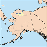
Alaska is the largest state in the United States by area. It is situated in the northwest extremity of the North American continent, with Canada to the east, the Arctic Ocean to the north, and the Pacific Ocean to the west and south, with Russia further west across the Bering Strait...
in the United States
United States
The United States of America is a federal constitutional republic comprising fifty states and a federal district...
, approximately 350 mi (560 km) long. One of the northernmost major rivers in the North America
North America
North America is a continent wholly within the Northern Hemisphere and almost wholly within the Western Hemisphere. It is also considered a northern subcontinent of the Americas...
, it drains a remote area of tundra
Tundra
In physical geography, tundra is a biome where the tree growth is hindered by low temperatures and short growing seasons. The term tundra comes through Russian тундра from the Kildin Sami word tūndâr "uplands," "treeless mountain tract." There are three types of tundra: Arctic tundra, alpine...
on the north side of the Brooks Range
Brooks Range
The Brooks Range is a mountain range in far northern North America. It stretches from west to east across northern Alaska and into Canada's Yukon Territory, a total distance of about 1100 km . The mountains top out at over 2,700 m . The range is believed to be approximately 126 million years old...
entirely above the Arctic Circle
Arctic Circle
The Arctic Circle is one of the five major circles of latitude that mark maps of the Earth. For Epoch 2011, it is the parallel of latitude that runs north of the Equator....
. The river is frozen for more than half the year and floods each spring.
It rises in an isolated area of the De Long Mountains, at the western end of the Brooks Range, north of the continental divide
Continental divide
A continental divide is a drainage divide on a continent such that the drainage basin on one side of the divide feeds into one ocean or sea, and the basin on the other side either feeds into a different ocean or sea, or else is endorheic, not connected to the open sea...
in the southwestern corner of the National Petroleum Reserve. It flows initially north, then generally east through the foothills on the north side of the range, broadening as it receives the inflow of many tributaries that descend from the middle Brooks Range. Along its middle course it forms the southeastern border of the National Petroleum Reserve. At the Inupiat Eskimo
Eskimo
Eskimos or Inuit–Yupik peoples are indigenous peoples who have traditionally inhabited the circumpolar region from eastern Siberia , across Alaska , Canada, and Greenland....
village of Umiat
Umiat, Alaska
Umiat is an unincorporated community in North Slope Borough, Alaska, United States, on the Colville River. It is located 140 miles southwest of Deadhorse in the Arctic Circle. The town is not accessible by road or rail. In 1944, the Naval Oil Reserve was set up and it later became an air force...
it turns north to flow across the Arctic plain, entering the western Beaufort Sea
Beaufort Sea
The Beaufort Sea is a marginal sea of the Arctic Ocean, located north of the Northwest Territories, the Yukon, and Alaska, west of Canada's Arctic islands. The sea is named after hydrographer Sir Francis Beaufort...
in a broad delta
River delta
A delta is a landform that is formed at the mouth of a river where that river flows into an ocean, sea, estuary, lake, reservoir, flat arid area, or another river. Deltas are formed from the deposition of the sediment carried by the river as the flow leaves the mouth of the river...
near Nuiqsut
Nuiqsut, Alaska
Nuiqsut is a city in North Slope Borough, Alaska, United States. At the 2000 census the population was 433.-Geography:Nuiqsut is located at ....
, approximately 120 mi (190 km) west of Prudhoe Bay
Prudhoe Bay, Alaska
Prudhoe Bay or Sagavanirktok is a census-designated place located in North Slope Borough in the U.S. state of Alaska. As of the 2010 census, the population of the CDP was 2,174 people; however, at any given time several thousand transient workers support the Prudhoe Bay oil field...
. When the river freezes to a suitable thickness during winter, it can be used as an ice road
Ice road
Ice roads are frozen, human-made structures on the surface of bays, rivers, lakes, or seas in the far north. They link dry land, frozen waterways, portages and winter roads, and are usually remade each winter. Ice roads allow temporary transport to areas with no permanent road access...
to bring in supplies, as seen during the fourth season of the History Channel series Ice Road Truckers
Ice Road Truckers
Ice Road Truckers is a documentary-style reality television series that premiered on History on June 17, 2007.-History:In 2000, History aired a 46-minute episode titled "Ice Road Truckers" as part of the Suicide Missions series...
.
The river valley contains unexploited petroleum
Petroleum
Petroleum or crude oil is a naturally occurring, flammable liquid consisting of a complex mixture of hydrocarbons of various molecular weights and other liquid organic compounds, that are found in geologic formations beneath the Earth's surface. Petroleum is recovered mostly through oil drilling...
and natural gas
Natural gas
Natural gas is a naturally occurring gas mixture consisting primarily of methane, typically with 0–20% higher hydrocarbons . It is found associated with other hydrocarbon fuel, in coal beds, as methane clathrates, and is an important fuel source and a major feedstock for fertilizers.Most natural...
deposits. A current proposal by the State of Alaska to bridge the river near Nuiqsut would be the first major river crossing north of the Arctic Circle in North America.
Named after Edward Colville Griffith who surveyed the region prior to the U.S. purchase.