
Brooks Range
Encyclopedia
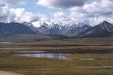
The Brooks Range is a mountain range
in far northern North America
. It stretches from west to east across northern Alaska
and into Canada
's Yukon Territory, a total distance of about 1100 km (700 mi). The mountains top out at over 2,700 m (9,000 ft). The range is believed to be approximately 126 million years old. These mountains are considered part of (or an extension of) the Rockies
.
The range is mostly uninhabited, but the Dalton Highway
and the Trans-Alaska Pipeline System
run through the Atigun Pass
(1,415 m, 4,643 ft) on their way to the North Slope
and the oil field
s at Prudhoe Bay. The Alaska Native villages of Anaktuvuk
and Arctic Village
, as well as the very small communities of Coldfoot
, Wiseman
, Bettles, and Chandalar Lake
are the only settlements in the 700-mile Brooks Range. In the far west, near the Wulik River in the De Long Mountains is the Red Dog mine
, largest zinc mine in the world.
The range was named by the United States Board on Geographic Names
in 1925 after Alfred Hulse Brooks
, who was the chief USGS
geologist for Alaska from 1903 to 1924.
Various historical records also referred to the range as the Arctic Mountains, Hooper Mountains, Meade Mountains and Meade River Mountains; the Canadian portion is still often referred to as the British Mountains. The British Mountains are part of Ivvavik National Park
.
Other notable peaks include:
Some sources, including the USGS 1:250,000 scale map Demarcation Point A-5, quote Mount Isto's height as 9,050 ft, which would make it the highest point in the range. Also, some sources quote Mount Michelson's height as 9,239 ft, which would make it the highest point; however, this is far above the 8,855 foot figure given on the USGS Mount Michelson B-1 quadrangle topographic map, so it is unlikely to be correct.
in North America, separating streams flowing into the Arctic Ocean and the North Pacific. The range roughly delineates the summer position of the Arctic front. It represents the northern extent of tree line, with few trees (apart from some isolated Balsam poplar
stands) occurring north of the continental drainage divide. The southern slopes of the Brooks Range have some cover of Black Spruce
, Picea mariana, and Quaking Aspen, marking the northern limit of those trees. As one of the most remote and least-disturbed wildernesses of North America, the mountains are teeming with wildlife, including Dall sheep
, grizzly bear
s, and caribou.
In Alaska, the Western Arctic Caribou herd traverses the Brooks Range in its annual migration. This herd was measured at 490,000 animals in 2004. The smaller Central Arctic herd (32,000 in 2002), as well as the 123,000 strong Porcupine Caribou herd, likewise travel through the Brooks range on their migratory paths in and out of the Arctic National Wildlife Refuge. The migratory path of the Porcupine Caribou Herd is the longest of any terrestrial mammal on earth.
Mountain range
A mountain range is a single, large mass consisting of a succession of mountains or narrowly spaced mountain ridges, with or without peaks, closely related in position, direction, formation, and age; a component part of a mountain system or of a mountain chain...
in far northern North America
North America
North America is a continent wholly within the Northern Hemisphere and almost wholly within the Western Hemisphere. It is also considered a northern subcontinent of the Americas...
. It stretches from west to east across northern Alaska
Alaska
Alaska is the largest state in the United States by area. It is situated in the northwest extremity of the North American continent, with Canada to the east, the Arctic Ocean to the north, and the Pacific Ocean to the west and south, with Russia further west across the Bering Strait...
and into Canada
Canada
Canada is a North American country consisting of ten provinces and three territories. Located in the northern part of the continent, it extends from the Atlantic Ocean in the east to the Pacific Ocean in the west, and northward into the Arctic Ocean...
's Yukon Territory, a total distance of about 1100 km (700 mi). The mountains top out at over 2,700 m (9,000 ft). The range is believed to be approximately 126 million years old. These mountains are considered part of (or an extension of) the Rockies
Rocky Mountains
The Rocky Mountains are a major mountain range in western North America. The Rocky Mountains stretch more than from the northernmost part of British Columbia, in western Canada, to New Mexico, in the southwestern United States...
.
The range is mostly uninhabited, but the Dalton Highway
Dalton Highway
The James W. Dalton Highway, usually Dalton Highway is a 414-mile road in Alaska. It begins at the Elliott Highway, north of Fairbanks, and ends at Deadhorse near the Arctic Ocean and the Prudhoe Bay oil fields...
and the Trans-Alaska Pipeline System
Trans-Alaska Pipeline System
The Trans Alaska Pipeline System , includes the Trans Alaska Pipeline, 11 pump stations, several hundred miles of feeder pipelines, and the Valdez Marine Terminal. TAPS is one of the world's largest pipeline systems...
run through the Atigun Pass
Atigun Pass
Atigun Pass, elevation , is a high mountain pass across the Brooks Range in Alaska, located at the head of the Dietrich River.. It is where the Dalton Highway crosses the Continental Divide , and is the highest pass in Alaska that is maintained throughout the year. Atigun is the only pass in the...
(1,415 m, 4,643 ft) on their way to the North Slope
Alaska North Slope
The Alaska North Slope is the region of the U.S. state of Alaska located on the northern slope of the Brooks Range along the coast of two marginal seas of the Arctic Ocean, the Chukchi Sea being on the western side of Point Barrow, and the Beaufort Sea on the eastern.The region contains the...
and the oil field
Oil field
An oil field is a region with an abundance of oil wells extracting petroleum from below ground. Because the oil reservoirs typically extend over a large area, possibly several hundred kilometres across, full exploitation entails multiple wells scattered across the area...
s at Prudhoe Bay. The Alaska Native villages of Anaktuvuk
Anaktuvuk Pass, Alaska
Anaktuvuk Pass is a city in North Slope Borough, Alaska, United States. The population was 249 at the 2007 Census Bureau estimate.-Geography:...
and Arctic Village
Arctic Village, Alaska
Arctic Village is an unincorporated Native American village and a census-designated place in Yukon-Koyukuk Census Area, Alaska, United States. As of the 2000 census, the population of the CDP was 152. The village is located in the large Gwitch'in speaking region of Alaska, and the local dialect...
, as well as the very small communities of Coldfoot
Coldfoot, Alaska
Coldfoot is a census-designated place in Yukon-Koyukuk Census Area in the U.S. state of Alaska. The population was 13 at the 2000 census....
, Wiseman
Wiseman, Alaska
Wiseman is a census-designated place in Yukon-Koyukuk Census Area, Alaska, United States. The population was 21 at the 2000 census.Wiseman is a small mining community in the Brooks Range. It was founded by gold miners who abandoned the Slate Creek settlement around 1919...
, Bettles, and Chandalar Lake
Chandalar Lake
Chandalar Lake is a lake in Yukon-Koyukuk Census Area, Alaska, United States. It is located roughly north of Fairbanks near the Brooks Range. It is located near, although not in, the Arctic National Wildlife Refuge. The lake is approximately 9.5 miles in length....
are the only settlements in the 700-mile Brooks Range. In the far west, near the Wulik River in the De Long Mountains is the Red Dog mine
Red Dog mine
The Red Dog mine is a zinc and lead mine located in a remote region of the Arctic, within the boundaries of the Red Dog Mine census-designated place in the Northwest Arctic Borough of the U.S. state of Alaska....
, largest zinc mine in the world.
The range was named by the United States Board on Geographic Names
United States Board on Geographic Names
The United States Board on Geographic Names is a United States federal body whose purpose is to establish and maintain uniform usage of geographic names throughout the U.S. government.-Overview:...
in 1925 after Alfred Hulse Brooks
Alfred Hulse Brooks
Alfred Hulse Brooks was an American Geologist and served as chief geologist for Alaska for the United States Geological Survey from 1903 to 1924. He was a native of Ann Arbor, Michigan and graduated from Harvard University in 1894...
, who was the chief USGS
United States Geological Survey
The United States Geological Survey is a scientific agency of the United States government. The scientists of the USGS study the landscape of the United States, its natural resources, and the natural hazards that threaten it. The organization has four major science disciplines, concerning biology,...
geologist for Alaska from 1903 to 1924.
Various historical records also referred to the range as the Arctic Mountains, Hooper Mountains, Meade Mountains and Meade River Mountains; the Canadian portion is still often referred to as the British Mountains. The British Mountains are part of Ivvavik National Park
Ivvavik National Park
Ivvavik National Park is a national park located in the Yukon, Canada. Meaning "nursery" or "birthplace" in Inuvialuktun, this was the first national park to be established as a result of a land claim agreement with its natives.-See also:...
.
Peaks
- Mount ChamberlinMount Chamberlin (Alaska)Mount Chamberlin is the highest peak in the Brooks Range of northern Alaska in the United States. It is the highest peak for over 500 miles ; however, due to its remote location, it sees little climbing activity....
at 9020 ft (2,749 m), is generally considered to be the highest peak in the range.
Other notable peaks include:
- Mount Isto at 8,975 ft (2,736 m)
- Mount MichelsonMount Michelson (Brooks Range)Mount Michelson is a high peak in the Romanzof Mountains, part of the Brooks Range of northern Alaska in the United States. It is located about east of the highest peak in the range, Mount Chamberlin....
at 8,855 ft (2,699 m) - The Gates of Kiev at 7775 ft (2370 m), the highest point in the central part of the range, and
- Black Mountain at 5020 ft (1530 m) the highest point in the far western part of the range.
- Mount Doonerak
- Mount IgikpakMount IgikpakMount Igikpak is the highest peak in the Schwatka Mountains region of the Brooks Range. It is also the tallest mountain in Gates of the Arctic National Park, located in the US state of Alaska. Some sources list the height of its summit at 8,510'...
- Frigid Crags West Gate
- Boreal Mountain East Gate
Some sources, including the USGS 1:250,000 scale map Demarcation Point A-5, quote Mount Isto's height as 9,050 ft, which would make it the highest point in the range. Also, some sources quote Mount Michelson's height as 9,239 ft, which would make it the highest point; however, this is far above the 8,855 foot figure given on the USGS Mount Michelson B-1 quadrangle topographic map, so it is unlikely to be correct.
Ecology
This mountain range forms the northernmost drainage divideContinental divide
A continental divide is a drainage divide on a continent such that the drainage basin on one side of the divide feeds into one ocean or sea, and the basin on the other side either feeds into a different ocean or sea, or else is endorheic, not connected to the open sea...
in North America, separating streams flowing into the Arctic Ocean and the North Pacific. The range roughly delineates the summer position of the Arctic front. It represents the northern extent of tree line, with few trees (apart from some isolated Balsam poplar
Balsam poplar
The balsam poplars — also known as Populus sect. Tacamahaca — are a group of about 10 species of poplars, indigenous to North America and eastern Asia, distinguished by the balsam scent of their buds, the whitish undersides of their leaves, and the leaf petiole being round in cross-section...
stands) occurring north of the continental drainage divide. The southern slopes of the Brooks Range have some cover of Black Spruce
Black Spruce
Picea mariana is a species of spruce native to northern North America, from Newfoundland west to Alaska, and south to northern New York, Minnesota and central British Columbia...
, Picea mariana, and Quaking Aspen, marking the northern limit of those trees. As one of the most remote and least-disturbed wildernesses of North America, the mountains are teeming with wildlife, including Dall sheep
Dall Sheep
The Dall sheep , Ovis dalli, is a species of sheep native to northwestern North America, ranging from white to slate brown in color and having curved yellowish brown horns...
, grizzly bear
Grizzly Bear
The grizzly bear , also known as the silvertip bear, the grizzly, or the North American brown bear, is a subspecies of brown bear that generally lives in the uplands of western North America...
s, and caribou.
In Alaska, the Western Arctic Caribou herd traverses the Brooks Range in its annual migration. This herd was measured at 490,000 animals in 2004. The smaller Central Arctic herd (32,000 in 2002), as well as the 123,000 strong Porcupine Caribou herd, likewise travel through the Brooks range on their migratory paths in and out of the Arctic National Wildlife Refuge. The migratory path of the Porcupine Caribou Herd is the longest of any terrestrial mammal on earth.
Documented wilderness traverses of the Brooks Range
- Dick Griffith -- Kaktovik to KotzebueKotzebueKotzebue is the name of the following people:*August von Kotzebue, dramatist*Otto von Kotzebue, navigatorKotzebue is also the name of a place:*Kotzebue, Alaska*Kotzebue Sound...
, Alaska (1959-1979) by foot, raft, and kayak: first documented traverse. - Roman Dial -- Kaktovik to KotzebueKotzebueKotzebue is the name of the following people:*August von Kotzebue, dramatist*Otto von Kotzebue, navigatorKotzebue is also the name of a place:*Kotzebue, Alaska*Kotzebue Sound...
, Alaska (1986) by skis, foot, packraftPackraftPackraft and trail boat are colloquial terms for a small, portable inflatable boat designed for use in all bodies of water, including technical whitewater and ocean bays and fjords. A packraft is designed to be light enough to be carried for extended distances...
and kayakKayakA kayak is a small, relatively narrow, human-powered boat primarily designed to be manually propelled by means of a double blade paddle.The traditional kayak has a covered deck and one or more cockpits, each seating one paddler...
: first traverse in one year. - Keith Nyitray -- Fort McPherson, Northwest Territories, Canada to KotzebueKotzebueKotzebue is the name of the following people:*August von Kotzebue, dramatist*Otto von Kotzebue, navigatorKotzebue is also the name of a place:*Kotzebue, Alaska*Kotzebue Sound...
(1989-1990) by dog sled, snowshoes, foot, raft, and canoe: first continuous traverse of the entire range. 1,500 trail miles from CanadaCanadaCanada is a North American country consisting of ten provinces and three territories. Located in the northern part of the continent, it extends from the Atlantic Ocean in the east to the Pacific Ocean in the west, and northward into the Arctic Ocean...
to Kotzebue. See April '93 issue of "National Geographic." - Thor Tingey, Phillip Weidner, Sam Newburry, Dan Dryden -- Marsh Fork Canning River to Kobuk (2000) by foot and packraft.
- Dennis SchmittDennis SchmittDennis Schmitt , is a veteran explorer from UC Berkeley who, in 2005, discovered a new island formed by the retreat of an ice shelf in East Greenland...
-- Point Hope, Alaska to Mackenzie RiverMackenzie RiverThe Mackenzie River is the largest river system in Canada. It flows through a vast, isolated region of forest and tundra entirely within the country's Northwest Territories, although its many tributaries reach into four other Canadian provinces and territories...
, Northwest TerritoriesNorthwest TerritoriesThe Northwest Territories is a federal territory of Canada.Located in northern Canada, the territory borders Canada's two other territories, Yukon to the west and Nunavut to the east, and three provinces: British Columbia to the southwest, and Alberta and Saskatchewan to the south...
(1966-2001) by foot and dog sled: longest and first full length traverse. - Peter Vacco -- Bonnet Lake to Cape Lisburne (2003) by snowshoe and foot: first continuous foot traverse from CanadaCanadaCanada is a North American country consisting of ten provinces and three territories. Located in the northern part of the continent, it extends from the Atlantic Ocean in the east to the Pacific Ocean in the west, and northward into the Arctic Ocean...
. - Roman Dial -- Kivalina to Dalton HighwayDalton HighwayThe James W. Dalton Highway, usually Dalton Highway is a 414-mile road in Alaska. It begins at the Elliott Highway, north of Fairbanks, and ends at Deadhorse near the Arctic Ocean and the Prudhoe Bay oil fields...
without resupply (2006) by foot: fastest traverse (624 miles in 22 days, 7 hours, 40 minutes). - Bruce "Buck" Nelson -- Alaska YukonYukonYukon is the westernmost and smallest of Canada's three federal territories. It was named after the Yukon River. The word Yukon means "Great River" in Gwich’in....
border to KotzebueKotzebueKotzebue is the name of the following people:*August von Kotzebue, dramatist*Otto von Kotzebue, navigatorKotzebue is also the name of a place:*Kotzebue, Alaska*Kotzebue Sound...
Sound (2006) by foot and raft. - Andrew Skurka -- by foot and packraft as part of the 4,700-mile Alaska-Yukon Expedition in 2010.
Films
- 2007 - Gates of the Arctic: Alaska's Brooks Range
- 2008 - Alone Across Alaska: 1,000 Miles of Wilderness
Further reading
- Witmer, Dennis "Far to the North: Photographs from the Brooks Range" Far to the North Press (2008) ISBN 0977102807
- Kauffmann, John M. "Alaska's Brooks Range: The Ultimate Mountains" (Second Edition) Mountaineers Books (2005) ISBN 1594850089
- Brown, William E. "History of the Central Brooks Range: Gaunt Beauty, Tenuous Life" University of Alaska Press (2007) ISBN 1602230099
- Cooper, David "Brooks Range Passage" Mountaineers Books (1983) ISBN 089886061X
- Dover, J.H., I.L. Tailleur, and J.A. Dumoulin. (2004). Geologic and fossil locality maps of the west-central part of the Howard Pass quadrangle and part of the adjacent Misheguk Mountain quadrangle, Western Brooks Range, Alaska [Miscellaneous Field Studies; Map MF-2413]. Reston, Va.: U.S. Department of the Interior, U.S. Geological Survey.
- Krumhardt, A.P., A.G. Harris, and K.F. Watts. (1996). Lithostratigraphy, microlithofacies, and conodont biostratigraphy and biofacies of the Wahoo Limestone (Carboniferous), eastern Sadlerochit Mountains, northeast Brooks Range, Alaska U.S. Geological Survey Professional Paper 1568. Washington, D.C.: U.S. Department of the Interior, U.S. Geological Survey.
- Marshall, R. (1970). Alaska wilderness; exploring the Central Brooks Range 2nd ed. Berkeley: University of California Press. ISBN 0520244982
- Mayfield, C.F. et al. (1984). Reconnaissance geologic map of southeastern Misheguk Mountain quadrangle, Alaska [ Miscellaneous Investigations Series Map I-1503]. Reston, Va.: U.S. Department of the Interior, U.S. Geological Survey.
- Morin, R.L. (1997). Gravity and magnetic maps of part of the Drenchwater Creek stratiform zinc-lead-silver deposit, Howard Pass quadrangle, northwestern Brooks Range, Alaska [Open-file report 97-705]. Menlo Park, CA: U.S. Department of the Interior, U.S. Geological Survey.
- Morin, R.L. (1997). Gravity models of Abby Creek and Bion barite deposits, Howard Pass quadrangle, northwestern Brooks Range, Alaska [U.S. Geological Survey Open-file Report 97-704]. Menlo Park, CA: U.S. Department of the Interior, U.S. Geological Survey.
- Mull, C.G. et al. (1994). Geologic map of the Killik River quadrangle, Brooks Range, Alaska [U.S. Geological Survey Open-file Report 94-679]. Reston, Va: U.S. Department of the Interior, U.S. Geological Survey.
- Nelson, P.H. et al. (2006). Potential tight gas resources in a frontier province, Jurassic through Tertiary strata beneath the Brooks Range foothills, Arctic Alaska U.S. Geological Survey Open-file Report 2006-1172. Reston, VA: U.S. Department of the Interior, U.S. Geological Survey.
- U.S. Department of the Interior, U.S. Geological Survey. (2003). The natural dispersal of metals to the environment in the Wulik River-Ikalukrok Creek area, western Brooks Range, Alaska U.S. Geological Survey Fact Sheet 107-03. Reston, VA: author.
- U.S. Department of the Interior, U.S. Geological Survey. (1995). Natural environmental effects of silver-lead-zinc deposits in the Brooks Range, Alaska U.S. Geological Survey Fact Sheet 092-95. Reston, VA: author.