

Colton, Leeds
Encyclopedia
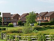
Colton is a district of east Leeds
, West Yorkshire
, England
, situated between Cross Gates to the north, Halton
and Halton Moor
to the west, Whitkirk
to the north-west and Austhorpe
to the north-east. Temple Newsam
lies directly south of the estate.
The small Whitkirk Lane End estate (which is situated between Colton Road and Colton Roundabout) is often considered more part of the Colton district than Whitkirk, because of its separation from Whitkirk via Selby Road, and its proximity to Colton Road.
s, with inter-linking ginnels, back alleys and housing ranges from detached houses, semi-detached houses, terraced houses, and flats. The area is 4 miles to the east of Leeds city centre
, and is close to the A63
dual carriageway
and M1 motorway
. Colton is also the area of Leeds, where the Leeds Outer Ring Road
terminates. The area is well served by buses, with the numbers 19 and 19A going to and from the city centre, and the number 9 going to and from Seacroft
.
At the centre of the estate, there is a cricket club, with a bar, a cricket pitch, two tennis courts and a football pitch. Much of the open space in Colton has been built upon, making it a much more urban area. In the mid-1990s, Colton Retail Park was opened in the east of the district, now with many well known stores. Recently, Thorpe Park business park was also opened in the east of Colton.
and anti-social behaviour
. As a result, an increased police presence was put into place in Colton and the surrounding estates.
road running through the west of the area into Whitkirk. It joins onto Selby Road, although it has been closed from the edge of Colton and Whitkirk to Meynell Road, where it terminates in the centre of the estate. It is locally referred to as 'The Old Road','The Red Road' or 'The Wide Path'.
Colton lies in the LS15 postcode area. This is a population comparison between the postcode area and the UK population.
Leeds
Leeds is a city and metropolitan borough in West Yorkshire, England. In 2001 Leeds' main urban subdivision had a population of 443,247, while the entire city has a population of 798,800 , making it the 30th-most populous city in the European Union.Leeds is the cultural, financial and commercial...
, West Yorkshire
West Yorkshire
West Yorkshire is a metropolitan county within the Yorkshire and the Humber region of England with a population of 2.2 million. West Yorkshire came into existence as a metropolitan county in 1974 after the passage of the Local Government Act 1972....
, England
England
England is a country that is part of the United Kingdom. It shares land borders with Scotland to the north and Wales to the west; the Irish Sea is to the north west, the Celtic Sea to the south west, with the North Sea to the east and the English Channel to the south separating it from continental...
, situated between Cross Gates to the north, Halton
Halton, Leeds
Halton is a district of east Leeds, West Yorkshire, England, situated between Cross Gates to the north, Halton Moor to the west, Colton to the east and Whitkirk to the South. Temple Newsam lies directly south of the estate.-History:...
and Halton Moor
Halton Moor
Halton Moor is a district of east Leeds, West Yorkshire, England, located around three miles east of Leeds city centre and is close to the A63. It is situated between Killingbeck to the north, Temple Newsam to the south, Osmondthorpe to the west and Halton and Colton to the east.The area is mainly...
to the west, Whitkirk
Whitkirk
Whitkirk is a suburb of east Leeds, situated between Cross Gates to the north, Austhorpe to the east, Killingbeck to the west, Colton to the south-east and Halton to the south-west...
to the north-west and Austhorpe
Austhorpe
Austhorpe is a civil parish in east Leeds, West Yorkshire, England that is situated between Pendas Fields to the north, Whitkirk to the west, Cross Gates to the north-west and Colton to the south-west....
to the north-east. Temple Newsam
Temple Newsam
Temple Newsam is a Tudor-Jacobean house with grounds landscaped by Capability Brown, in Leeds, West Yorkshire, England...
lies directly south of the estate.
The small Whitkirk Lane End estate (which is situated between Colton Road and Colton Roundabout) is often considered more part of the Colton district than Whitkirk, because of its separation from Whitkirk via Selby Road, and its proximity to Colton Road.
Geography
The name Colton derives from the old english Coal Town, because the estate was originally developed as a pit mining community in the east of the city. It consists mainly of cul-de-sacCul-de-sac
A cul-de-sac is a word of French origin referring to a dead end, close, no through road or court meaning dead-end street with only one inlet/outlet...
s, with inter-linking ginnels, back alleys and housing ranges from detached houses, semi-detached houses, terraced houses, and flats. The area is 4 miles to the east of Leeds city centre
Leeds City Centre
Leeds city centre is the central business district of Leeds, England. It is within the Leeds Central parliamentary constituency, represented by Hilary Benn as MP since a by-election in 1999...
, and is close to the A63
A63 road
The A63 is a major road in Yorkshire, England between Leeds and Hull.-Leeds – Howden:The route out to Selby is shadowed by the Leeds-Selby railway....
dual carriageway
Dual carriageway
A dual carriageway is a class of highway with two carriageways for traffic travelling in opposite directions separated by a central reservation...
and M1 motorway
M1 motorway
The M1 is a north–south motorway in England primarily connecting London to Leeds, where it joins the A1 near Aberford. While the M1 is considered to be the first inter-urban motorway to be completed in the United Kingdom, the first road to be built to motorway standard in the country was the...
. Colton is also the area of Leeds, where the Leeds Outer Ring Road
Leeds Outer Ring Road
The Leeds Outer Ring Road is a main road that runs around most of the perimeter of the city of Leeds, West Yorkshire, England. The ring road is approximately long and consists of single and dual carriageways....
terminates. The area is well served by buses, with the numbers 19 and 19A going to and from the city centre, and the number 9 going to and from Seacroft
Seacroft
Seacroft is an outer-city suburb consisting mainly of council estate housing covering an extensive area of east Leeds, West Yorkshire, England. It is east of Leeds city centre and lies in the LS14 Leeds postcode area....
.
At the centre of the estate, there is a cricket club, with a bar, a cricket pitch, two tennis courts and a football pitch. Much of the open space in Colton has been built upon, making it a much more urban area. In the mid-1990s, Colton Retail Park was opened in the east of the district, now with many well known stores. Recently, Thorpe Park business park was also opened in the east of Colton.
Police force
In the late 1990s to mid 2000s, Colton suffered social problems of crimeCrime
Crime is the breach of rules or laws for which some governing authority can ultimately prescribe a conviction...
and anti-social behaviour
Anti-social behaviour
Anti-social behaviour is behaviour that lacks consideration for others and that may cause damage to society, whether intentionally or through negligence, as opposed to pro-social behaviour, behaviour that helps or benefits society...
. As a result, an increased police presence was put into place in Colton and the surrounding estates.
Old Colton Road
Colton Road is a derelictDerelict
Derelict or dereliction commonly refers to:* Abandonment of property, then referred to as a 'derelict'* Derelict , property which has been abandoned and deserted at sea by those who were in charge without any hope of recovering it...
road running through the west of the area into Whitkirk. It joins onto Selby Road, although it has been closed from the edge of Colton and Whitkirk to Meynell Road, where it terminates in the centre of the estate. It is locally referred to as 'The Old Road','The Red Road' or 'The Wide Path'.
Comparison
Colton lies in the LS15 postcode area. This is a population comparison between the postcode area and the UK population.
| Category | LS15 | UK average |
|---|---|---|
| Population density (people / sq mi) | 43.2 | 24.9 |
| Gender split (females / male) | 1.05 | 1.05 |
| Average commute | 6.1 miles | 8.73 miles |
| Average age | 38 | 39 |
| Home ownership | 16% | 16.9% |
| Student population | 2.4% | 4.4% |
| People in good health | 69% | 69% |