

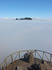
Cloud top
Encyclopedia
Altitude
Altitude or height is defined based on the context in which it is used . As a general definition, altitude is a distance measurement, usually in the vertical or "up" direction, between a reference datum and a point or object. The reference datum also often varies according to the context...
of the visible portion of the cloud
Cloud
A cloud is a visible mass of liquid droplets or frozen crystals made of water and/or various chemicals suspended in the atmosphere above the surface of a planetary body. They are also known as aerosols. Clouds in Earth's atmosphere are studied in the cloud physics branch of meteorology...
. It is traditionally expressed either in metres above the Earth (or planetary) surface, or as the corresponding pressure
Pressure
Pressure is the force per unit area applied in a direction perpendicular to the surface of an object. Gauge pressure is the pressure relative to the local atmospheric or ambient pressure.- Definition :...
level in hectopascal (hPa, equivalent to the traditional but now obsolete millibar).
Measurement
The cloud top is where the snow, rain and sleet come from.Cloud top height can be estimated from the ground by triangulation
Triangulation
In trigonometry and geometry, triangulation is the process of determining the location of a point by measuring angles to it from known points at either end of a fixed baseline, rather than measuring distances to the point directly...
. However, this is often inconvenient as this is practically feasible only for isolated clouds in full view of (and some horizontal distance away from) the observers. Ground-based radars can be used to derive this cloud property (see this paper for a comparison of this approach to a satellite-based method).
An alternative (but also more expensive) approach is to acquire airborne observations either visually or using specific instruments such as a lidar
LIDAR
LIDAR is an optical remote sensing technology that can measure the distance to, or other properties of a target by illuminating the target with light, often using pulses from a laser...
. This technique is very appropriate to characterize individual clouds (and specifically to control or evaluate the accuracy of other methods) but becomes unmanageable to repetitively monitor clouds over large areas (see this paper for an example using this approach).
Cloud top height may be derived from satellite
Satellite
In the context of spaceflight, a satellite is an object which has been placed into orbit by human endeavour. Such objects are sometimes called artificial satellites to distinguish them from natural satellites such as the Moon....
measurements, either through stereophotogrammetry (using pairs of images acquired at different observation angles) or by converting temperature measurements into estimations of height. An example of the stereo technique using the Multi-angle Imaging SpectroRadiometer
MISR
The Multi-angle Imaging SpectroRadiometer is a scientific instrument on the Terra satellite launched by NASA on December 18, 1999. This device is designed to measure the intensity of solar radiation reflected by the Earth system in various directions and spectral bands; it became operational in...
(MISR) instrument can be found here, and using the Along Track Scanning Radiometer
AATSR
The Advanced Along Track Scanning Radiometer is one of the Announcement of Opportunity instruments on board the European Space Agency 's Envisat satellite....
instruments (ATSR-1, ATSR-2 and AATSR) here. An
example of the estimation of cloud top height from temperature measurements is available from this paper.
Cloud top pressure can also be used as an indicator of cloud top height. The Cooperative Institute for Meteorological Satellite Studies (CIMSS) provides real-time cloud top pressure maps of the conterminous United States derived from data obtained from the GOES
Geostationary Operational Environmental Satellite
The Geostationary Satellite system, operated by the United States National Environmental Satellite, Data, and Information Service , supports weather forecasting, severe storm tracking, and meteorology research. Spacecraft and ground-based elements of the system work together to provide a continuous...
11 and GOES 12 satellites.
Weather and climate relevance
In convective clouds, the cloud top is largely influenced by the strength of the convectionConvection
Convection is the movement of molecules within fluids and rheids. It cannot take place in solids, since neither bulk current flows nor significant diffusion can take place in solids....
activity, which itself may depend on surface properties, in particular the supply of heat and water vapor below the cloud. Cloud top height is often much more variable than cloud base
Cloud base
This article refers to meteorology. For the airborne base of the TV series Captain Scarlet and the Mysterons, see Cloudbase.The cloud base is the lowest altitude of the visible portion of the cloud...
elevation.
Clouds greatly affect the transfer of radiation in the atmosphere. In the solar spectral domain, cloud albedo
Cloud albedo
Cloud albedo is a measure of the albedo of a cloud - higher values mean that the cloud reflects more solar radiation, or more radiation is transmitted....
is directly related to the nature, size and shape of cloud particles, which themselves are affected by the height of the cloud top. In the thermal domain, water is a strong absorber (and thus emitter, according to Kirchhoff's law of thermal radiation
Kirchhoff's law of thermal radiation
In thermodynamics, Kirchhoff's law of thermal radiation, or Kirchhoff's law for short, is a general statement equating emission and absorption in heated objects, proposed by Gustav Kirchhoff in 1859, following from general considerations of thermodynamic equilibrium and detailed balance.An object...
). Hence clouds cool down from the top through infrared radiation at the prevailing temperature: the higher the cloud top, the cooler the particles and the lower the rate of emission. For a synthetic discussion of the impact of clouds (and in particular the role of cloud tops) on the climate system, see the IPCC Third Assessment Report, in particular chapter 7.2.