

Claiborne Avenue
Encyclopedia
Claiborne Avenue is a major thoroughfare in New Orleans
, Louisiana
. It runs the length of the city, about 9.5 miles (15.3 km), beginning at the Jefferson Parish
line and ending at the St. Bernard Parish
line; the street continues in each of these locations under different names. It is called South Claiborne Avenue upriver from Canal Street
and North Claiborne Avenue from Canal to St. Bernard Parish. It is named in honor of William C. C. Claiborne, the first United States
governor of Louisiana.
.
; before crossing the parish line it is called Jefferson Highway
. Highway 90 shifts to Broad Street as it meanders its way out of New Orleans toward Slidell
, while Claiborne continues towards the Central Business District
. The section from Jefferson Parish to the large interchange at Earhart Boulevard
and Interstate 10
visibly follows the crescent in the river, from about a mile inland, that gives New Orleans its nickname. For this stretch, the street is six lanes, three in each direction, with a neutral ground
in the middle. It passes through a mix of residential and commercial districts.
neighborhood; in several phases there had been a street named for Governor Claiborne since the neighborhood was first developed in the early nineteenth century. The wide neutral ground was lined with live oak
trees, and the public green space served as a center of congregation for the area's primariliy African-American residents. The Claiborne intersection at Orleans Avenue, in the heart of Treme, remains a primary meeting ground for the Mardi Gras Indians
.
This stretch of Claiborne is primarily commercial, with residential neighborhoods throughout the adjacent blocks. It traditionally served as an important African-American shopping district, a counterweight to Canal Street
, which catered to the white community. For three blocks, Claiborne also passes the old Saint Louis Cemetery
#2 in this section.
. The original design called for the Interstate to be built along the river through the French Quarter. A successful campaign was organized by French Quarter
residents and preservations to redirect that stretch of Interstate. The width of Claiborne Avenue provided the second most convenient route for construction, while still bringing the interstate very close to the Central Business District and the French Quarter, a few blocks from Claiborne. The opposition of the largely African-American and disenfranchised residents of Treme was not enough to stop the project from going forward. After construction, cement parking lots replaced the grassy neutral ground and supports for the interstate replaced the old oak trees, permanently changing the streetscape. It is commonly held that the construction of the overpass was intimately tied to the overall decline of the Treme neighborhood in the 60's and 70's. As part of the 2002 "Restore the Oaks" program, some of the round supports were painted by various local artists, while others were painted to resemble oak trees.
 In the wake of Hurricane Katrina, many have called for the removal of the I-10 Claiborne overpass, rerouting I-10 to the I-610 corridor. Suppoters cite the structure's need for costly repairs and damage it has caused and continues to cause to what could potentially be a thiving urban neighborhood. Opponents argue that the overpass' removal would cause great inconvenience to the residents of New Orleans East and potentially require unwanted and intrusive expansion of the I-610 corridor. The September 14th, 2009 draft of the New Orleans Master Plan calls for the study and eventual removal of the overpass.
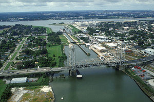
. At this point Claiborne Avenue is technically only the westbound side, a block away. The two rejoin at the Claiborne Avenue Bridge
over the Industrial Canal
, and the street continues through the Lower Ninth Ward
to St. Bernard Parish, where it becomes Judge Perez Drive.
New Orleans, Louisiana
New Orleans is a major United States port and the largest city and metropolitan area in the state of Louisiana. The New Orleans metropolitan area has a population of 1,235,650 as of 2009, the 46th largest in the USA. The New Orleans – Metairie – Bogalusa combined statistical area has a population...
, Louisiana
Louisiana
Louisiana is a state located in the southern region of the United States of America. Its capital is Baton Rouge and largest city is New Orleans. Louisiana is the only state in the U.S. with political subdivisions termed parishes, which are local governments equivalent to counties...
. It runs the length of the city, about 9.5 miles (15.3 km), beginning at the Jefferson Parish
Jefferson Parish, Louisiana
Jefferson Parish is a parish in Louisiana, United States that includes most of the suburbs of New Orleans. The seat of parish government is Gretna....
line and ending at the St. Bernard Parish
St. Bernard Parish, Louisiana
St. Bernard Parish is a parish located southeast of New Orleans in the U.S. state of Louisiana. The parish seat is Chalmette, the largest city in the parish. As of 2000, its population was 67,229. It has been ranked the fastest-growing county in the United States from 2007 to 2008 by the U.S....
line; the street continues in each of these locations under different names. It is called South Claiborne Avenue upriver from Canal Street
Canal Street, New Orleans
Canal Street is a major thoroughfare in the city of New Orleans. Forming the upriver boundary of the city's oldest neighborhood, the French Quarter , it acted as the dividing line between the older French/Spanish Colonial-era city and the newer American Sector, today's Central Business District.The...
and North Claiborne Avenue from Canal to St. Bernard Parish. It is named in honor of William C. C. Claiborne, the first United States
United States
The United States of America is a federal constitutional republic comprising fifty states and a federal district...
governor of Louisiana.
Route description
Claiborne Avenue can be divided into three general sections as it winds through the city, following the curves of the Mississippi RiverMississippi River
The Mississippi River is the largest river system in North America. Flowing entirely in the United States, this river rises in western Minnesota and meanders slowly southwards for to the Mississippi River Delta at the Gulf of Mexico. With its many tributaries, the Mississippi's watershed drains...
.
The Crescent
For the first few miles in the city coming from Jefferson Parish, Claiborne Avenue is part of U.S. Highway 90U.S. Route 90 in Louisiana
U.S. Highway 90, one of the major east–west U.S. Highways in the Southern United States, runs through southern Louisiana for , serving Lake Charles, Lafayette, New Iberia, Morgan City and New Orleans...
; before crossing the parish line it is called Jefferson Highway
Jefferson Highway
The Jefferson Highway was an automobile highway stretching through the central United States from New Orleans, Louisiana, to Winnipeg, Manitoba, Canada. The Jefferson Highway was replaced with the new numbered US Highway system in the late 1920s...
. Highway 90 shifts to Broad Street as it meanders its way out of New Orleans toward Slidell
Slidell, Louisiana
Slidell is a city situated on the northeast shore of Lake Pontchartrain in St. Tammany Parish, Louisiana, United States. The population was 25,695 at the 2000 census. The Greater Slidell Community has a population of about 90,000...
, while Claiborne continues towards the Central Business District
New Orleans Central Business District
The Central Business District is a neighborhood of the city of New Orleans. A subdistrict of the French Quarter/CBD Area, its boundaries as defined by the City Planning Commission are: Iberville, Decatur and Canal Streets to the north, the Mississippi River to the east, the New Orleans Morial...
. The section from Jefferson Parish to the large interchange at Earhart Boulevard
Earhart Expressway
The Earhart Expressway, named for Frederick Earhart, is a state highway located in both Jefferson Parish and Orleans Parish, Louisiana. It is also designated as Louisiana Highway 3139 or LA 3139...
and Interstate 10
Interstate 10 in Louisiana
Interstate 10, a major transcontinental Interstate Highway in the Southern U.S., runs across the southern part of the U.S. state of Louisiana. It passes through Lake Charles, Lafayette and Baton Rouge before dipping south of Lake Pontchartrain to serve the New Orleans area and then passing through...
visibly follows the crescent in the river, from about a mile inland, that gives New Orleans its nickname. For this stretch, the street is six lanes, three in each direction, with a neutral ground
Central reservation
On divided roads, such as divided highways or freeways/motorways, the central reservation , median, parkway , median strip or central nature strip is the area which separates opposing lanes of traffic...
in the middle. It passes through a mix of residential and commercial districts.
Through the Treme
The oldest section of Claiborne Avenue runs through the TremeTreme
Tremé is a neighborhood of the city of New Orleans. A subdistrict of the Mid-City District Area, its boundaries as defined by the City Planning Commission are Esplanade Avenue to the north, North Rampart Street to the east, St. Louis Street to the south and North Broad Street to the west...
neighborhood; in several phases there had been a street named for Governor Claiborne since the neighborhood was first developed in the early nineteenth century. The wide neutral ground was lined with live oak
Live oak
Live oak , also known as the southern live oak, is a normally evergreen oak tree native to the southeastern United States...
trees, and the public green space served as a center of congregation for the area's primariliy African-American residents. The Claiborne intersection at Orleans Avenue, in the heart of Treme, remains a primary meeting ground for the Mardi Gras Indians
Mardi Gras Indians
Mardi Gras Indians are African-American Carnival revelers in New Orleans, Louisiana, who dress up for Mardi Gras in suits influenced by Native American ceremonial apparel.Collectively, their organizations are called "tribes"...
.
This stretch of Claiborne is primarily commercial, with residential neighborhoods throughout the adjacent blocks. It traditionally served as an important African-American shopping district, a counterweight to Canal Street
Canal Street, New Orleans
Canal Street is a major thoroughfare in the city of New Orleans. Forming the upriver boundary of the city's oldest neighborhood, the French Quarter , it acted as the dividing line between the older French/Spanish Colonial-era city and the newer American Sector, today's Central Business District.The...
, which catered to the white community. For three blocks, Claiborne also passes the old Saint Louis Cemetery
Saint Louis Cemetery
Saint Louis Cemetery is the name of three Roman Catholic cemeteries in New Orleans, Louisiana. All of these graves are above ground vaults; most were constructed in the 18th century and 19th century....
#2 in this section.
Overshadowed by I-10
One of the most controversial developments in New Orleans' history involved the construction of Interstate 10 through the Treme neighborhood as an elevated freeway above the oldest section of Claiborne Avenue in the late 1960s. The construction generally followed vacant land, such as the filled-in New Basin CanalNew Basin Canal
The New Basin Canal, also known as the New Orleans Canal and the New Canal, was a shipping canal in New Orleans, Louisiana from the 1830s through the 1940s....
. The original design called for the Interstate to be built along the river through the French Quarter. A successful campaign was organized by French Quarter
French Quarter
The French Quarter, also known as Vieux Carré, is the oldest neighborhood in the city of New Orleans. When New Orleans was founded in 1718 by Jean-Baptiste Le Moyne de Bienville, the city was originally centered on the French Quarter, or the Vieux Carré as it was known then...
residents and preservations to redirect that stretch of Interstate. The width of Claiborne Avenue provided the second most convenient route for construction, while still bringing the interstate very close to the Central Business District and the French Quarter, a few blocks from Claiborne. The opposition of the largely African-American and disenfranchised residents of Treme was not enough to stop the project from going forward. After construction, cement parking lots replaced the grassy neutral ground and supports for the interstate replaced the old oak trees, permanently changing the streetscape. It is commonly held that the construction of the overpass was intimately tied to the overall decline of the Treme neighborhood in the 60's and 70's. As part of the 2002 "Restore the Oaks" program, some of the round supports were painted by various local artists, while others were painted to resemble oak trees.
Towards St. Bernard Parish
At St. Bernard Avenue (not to be confused with the parish), Claiborne and the Interstate part as the street continues to follow the river. It becomes a four-lane divided street, and then the eastbound (downriver) lanes separate from Claiborne to join North Robertson, a one-way street, through the upper Ninth WardNinth Ward of New Orleans
The Ninth Ward or 9th Ward is a distinctive region of New Orleans, Louisiana that is located in the easternmost downriver portion of the city. It is geographically the largest of the 17 Wards of New Orleans....
. At this point Claiborne Avenue is technically only the westbound side, a block away. The two rejoin at the Claiborne Avenue Bridge
Claiborne Avenue Bridge
The Claiborne Avenue Bridge, officially known as the Judge William Seeber Bridge, is a vertical lift bridge in New Orleans, Louisiana over the Industrial Canal. It was built by the Louisiana Department of Highways and opened to vehicular traffic in 1957...
over the Industrial Canal
Industrial Canal
The Industrial Canal is a 5.5 mile waterway in New Orleans, Louisiana, United States. The waterway's proper name, as used by the U.S. Army Corps of Engineers and on NOAA nautical charts, is Inner Harbor Navigation Canal...
, and the street continues through the Lower Ninth Ward
Lower Ninth Ward
Lower Ninth Ward is a neighborhood of the city of New Orleans. As the name implies, it is part of the Ninth Ward of New Orleans. The Lower Ninth Ward is often thought of as the entire area within New Orleans downriver of the Industrial Canal; however, the City Planning Commission divides this...
to St. Bernard Parish, where it becomes Judge Perez Drive.