
Citico Creek Wilderness
Encyclopedia
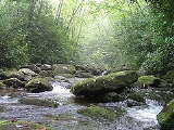
Citico Creek Wilderness is a 16226 acres (66 km²) wilderness area within the Cherokee National Forest
in the U.S. state
of Tennessee
. The wilderness contains the entire upper drainage of Citico Creek, which consists of the north and south forks and at least eight tributaries. Three steep-sided ridges descend west from the crest of the Unicoi Mountains — Brush Mountain, Pine Ridge, and Sassafras Ridge.
village of Citico
, which was located at the creek's mouth along the Little Tennessee River
. The village site was inundated by the creation of Tellico Reservoir
in 1979.
Most of the Citico Creek watershed was logged in the early 1920s by the Babcock Lumber Company, and most of what was not logged was destroyed by a massive forest fire in 1925. The United States Forest Service
purchased the devastated land in the 1930s, and its policy of allowing natural processes to heal the forest has led to the development of a mature, second-growth deciduous
forest
along Citico Creek.
hardwood forests— which include yellow poplar, white oak, red oak, and hemlock— are found in the bottomlands along stream beds. The ridge slopes are covered by a mixed hardwood-pine forest consisting primarily of white oak, red oak, and hickory in moist areas and substantial stands of white pine, pitch pine, and shortleaf pine on drier slopes and ridgecrests.
While most of the forest is second-growth, two pockets of old growth forest remain within the wilderness area. One is a 187 acre (0.75676282 km²) stand of primarily beech and maple in the vicinity of Falls Branch Falls, which is easily accessible from the Cherohala Skyway
via the Falls Branch Falls Trail. The other is an isolated 200 acre (0.809372 km²) patch of hemlock near Glenn Gap.
and on the north by the Great Smoky Mountains National Park
(on the other side of the Little Tennessee River). The Bald River Gorge Wilderness is located immediately to the southwest. The Cherohala Skyway traverses the southern boundary of the Citico Creek Wilderness, and the Benton MacKaye Trail
roughly follows its eastern boundary.
Cherokee National Forest
The Cherokee National Forest is a large National Forest created on July 19, 1936, by U.S. President Franklin Roosevelt, operated by the U.S. Forest Service and encompassing some 640,000 acres .-Location:...
in the U.S. state
U.S. state
A U.S. state is any one of the 50 federated states of the United States of America that share sovereignty with the federal government. Because of this shared sovereignty, an American is a citizen both of the federal entity and of his or her state of domicile. Four states use the official title of...
of Tennessee
Tennessee
Tennessee is a U.S. state located in the Southeastern United States. It has a population of 6,346,105, making it the nation's 17th-largest state by population, and covers , making it the 36th-largest by total land area...
. The wilderness contains the entire upper drainage of Citico Creek, which consists of the north and south forks and at least eight tributaries. Three steep-sided ridges descend west from the crest of the Unicoi Mountains — Brush Mountain, Pine Ridge, and Sassafras Ridge.
History
Citico Creek is named after the ancient Overhill CherokeeOverhill Cherokee
The term Overhill Cherokee refers to the former Cherokee settlements located in what is now Tennessee in the southeastern United States. The name was given by 18th century European traders and explorers who had to cross the Appalachian Mountains to reach these settlements when traveling from...
village of Citico
Citico (Tellico archaeological site)
Citico is a prehistoric and historic Native American site in Monroe County, Tennessee, in the southeastern United States. The site's namesake Cherokee village was the largest of the Overhill towns, housing an estimated population of 1,000 by the mid-18th century...
, which was located at the creek's mouth along the Little Tennessee River
Little Tennessee River
The Little Tennessee River is a tributary of the Tennessee River, approximately 135 miles long, in the Appalachian Mountains in the southeastern United States.-Geography:...
. The village site was inundated by the creation of Tellico Reservoir
Tellico Reservoir
Tellico Reservoir, also known as Tellico Lake, is a reservoir in Tennessee, created by the Tennessee Valley Authority in 1979 upon the completion of Tellico Dam. The dam impounds the Little Tennessee River and the lower Tellico River...
in 1979.
Most of the Citico Creek watershed was logged in the early 1920s by the Babcock Lumber Company, and most of what was not logged was destroyed by a massive forest fire in 1925. The United States Forest Service
United States Forest Service
The United States Forest Service is an agency of the United States Department of Agriculture that administers the nation's 155 national forests and 20 national grasslands, which encompass...
purchased the devastated land in the 1930s, and its policy of allowing natural processes to heal the forest has led to the development of a mature, second-growth deciduous
Deciduous
Deciduous means "falling off at maturity" or "tending to fall off", and is typically used in reference to trees or shrubs that lose their leaves seasonally, and to the shedding of other plant structures such as petals after flowering or fruit when ripe...
forest
Forest
A forest, also referred to as a wood or the woods, is an area with a high density of trees. As with cities, depending where you are in the world, what is considered a forest may vary significantly in size and have various classification according to how and what of the forest is composed...
along Citico Creek.
Forest
Diverse coveCove (Appalachian Mountains)
In the central and southern Appalachian Mountains of Eastern North America, a cove is a small valley between two ridge lines that is closed at one or both ends....
hardwood forests— which include yellow poplar, white oak, red oak, and hemlock— are found in the bottomlands along stream beds. The ridge slopes are covered by a mixed hardwood-pine forest consisting primarily of white oak, red oak, and hickory in moist areas and substantial stands of white pine, pitch pine, and shortleaf pine on drier slopes and ridgecrests.
While most of the forest is second-growth, two pockets of old growth forest remain within the wilderness area. One is a 187 acre (0.75676282 km²) stand of primarily beech and maple in the vicinity of Falls Branch Falls, which is easily accessible from the Cherohala Skyway
Cherohala Skyway
The Cherohala Skyway is a National Scenic Byway that connects Tellico Plains, Tennessee, to Robbinsville, North Carolina in the southeastern United States. Its name is a portmanteau of Cherokee and Nantahala, the two national forests through which it passes...
via the Falls Branch Falls Trail. The other is an isolated 200 acre (0.809372 km²) patch of hemlock near Glenn Gap.
Recreation and protection
Citico Creek Wilderness is bordered on the east by the Joyce Kilmer-Slickrock WildernessJoyce Kilmer-Slickrock Wilderness
Joyce Kilmer-Slickrock Wilderness, created in 1975, covers in the Nantahala National Forest in western North Carolina and the Cherokee National Forest in eastern Tennessee, in the watersheds of the Slickrock and Little Santeetlah Creeks...
and on the north by the Great Smoky Mountains National Park
Great Smoky Mountains National Park
Great Smoky Mountains National Park is a United States National Park and UNESCO World Heritage Site that straddles the ridgeline of the Great Smoky Mountains, part of the Blue Ridge Mountains, which are a division of the larger Appalachian Mountain chain. The border between Tennessee and North...
(on the other side of the Little Tennessee River). The Bald River Gorge Wilderness is located immediately to the southwest. The Cherohala Skyway traverses the southern boundary of the Citico Creek Wilderness, and the Benton MacKaye Trail
Benton MacKaye Trail
The Benton MacKaye Trail or BMT is a footpath nearly in length in the Appalachian Mountains in the southeastern United States and is blazed by a white diamond, 5" across by 7" tall...
roughly follows its eastern boundary.
See also
- Appalachian MountainsAppalachian MountainsThe Appalachian Mountains #Whether the stressed vowel is or ,#Whether the "ch" is pronounced as a fricative or an affricate , and#Whether the final vowel is the monophthong or the diphthong .), often called the Appalachians, are a system of mountains in eastern North America. The Appalachians...
- Blue Ridge MountainsBlue Ridge MountainsThe Blue Ridge Mountains are a physiographic province of the larger Appalachian Mountains range. This province consists of northern and southern physiographic regions, which divide near the Roanoke River gap. The mountain range is located in the eastern United States, starting at its southern-most...
- List of U.S. Wilderness Areas
- Wilderness ActWilderness ActThe Wilderness Act of 1964 was written by Howard Zahniser of The Wilderness Society. It created the legal definition of wilderness in the United States, and protected some 9 million acres of federal land. The result of a long effort to protect federal wilderness, the Wilderness Act was signed...
External links
- Citico Creek Wilderness - Wilderness.net