

Chief Moses
Encyclopedia
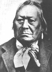
Sinkiuse-Columbia
The Sinkiuse-Columbia were a Native American tribe so-called because of their former prominent association with the Columbia River. They called themselves .tskowa'xtsEnux, or .skowa'xtsEnEx , or Sinkiuse. They applied the name also to other neighboring Interior Salish peoples...
, in what is now Washington State. The territory of his tribe extended approximately from Waterville
Waterville, Washington
Waterville is a town in and the county seat of Douglas County, Washington, United States. It is part of the Wenatchee–East Wenatchee Metropolitan Statistical Area. The population was 1,138 at the 2010 census.-History:...
to White Bluffs
White Bluffs, Washington
White Bluffs was an agricultural town in Benton County, Washington, United States. It was evacuated in 1943 along with the town of Hanford to make room for the nuclear production facility known as the Hanford Site....
, in the Columbia Basin
Columbia Basin
The Columbia Basin, the drainage basin of the Columbia River, occupies a large area–about —of the Pacific Northwest region of North America. In common usage, the term often refers to a smaller area, generally the portion of the drainage basin that lies within eastern Washington.Usage of the term...
. They were often in the area around Moses Lake
Moses Lake
Moses Lake is a lake and reservoir along the course of Crab Creek, in Washington state, USA.Moses Lake is part of the Columbia River basin, as Crab Creek is a tributary of the Columbia River....
. The tribe numbered perhaps a few hundred individuals.
Background
The boy who would become Chief Moses was the third son of Chief Sulk-stalk-scosum; his mother was Sulk-stalk-scosum's senior wife Kanitsa. He had two older brothers and four younger ones. In childhood he was named Loo-low-kin (Head Band), but in later life Chief Moses took the name of his father, Sulk-stalk-scosum. His people lived in the Moses Lake area.At the age of nine, he so impressed the missionary Henry H. Spalding
Henry H. Spalding
Henry Harmon Spalding , and his wife Eliza Hart Spalding were prominent Presbyterian missionaries and educators working primarily with the Nez Perce in the U.S. Pacific Northwest...
that he was invited to be educated at the Presbyterian Mission of Lapwai, Idaho
Lapwai, Idaho
Lapwai is a city in Nez Perce County, Idaho, United States. The population was 1,137 at the 2010 census. It is the seat of government of the Nez Perce Indian Reservation.Lapwai is part of the Lewiston, ID-WA Metropolitan Statistical Area.-Geography:...
, where for three years he learned the ways of whites and also made extensive contacts with Nez Perce, in whose territory the Mission was located. He became fluent in several languages, including English
English language
English is a West Germanic language that arose in the Anglo-Saxon kingdoms of England and spread into what was to become south-east Scotland under the influence of the Anglian medieval kingdom of Northumbria...
, Nez Perce, Spokane, Colville and Yakima, a skill that served him later in life. It was at the mission where he was given the Christian name "Moses" by Spalding, which he would go by for the rest of his life despite never officially becoming a Christian
Christian
A Christian is a person who adheres to Christianity, an Abrahamic, monotheistic religion based on the life and teachings of Jesus of Nazareth as recorded in the Canonical gospels and the letters of the New Testament...
.
At the time of the Yakima War
Yakima War
The Yakima War was a conflict between the United States and the Yakama, a Sahaptian-speaking people on the Northwest Plateau, then Washington Territory and now the southern interior of Eastern Washington, from 1855 to 1858.- Naming :...
, his brother Kwilninuk was chief of the Sinkiuse-Columbia; Moses had a minor role and following their defeat in 1858 surrendered in Chewelah. While Moses was away from the tribe, being examined and later negotiating, the tribe proclaimed him their chief; when he returned to their encampment near Ephrata, he assumed the duties and the name of his deceased father.
He was chief of the Sinkiuse-Columbia for forty years, during which time white encroachment increased and so did conflict. He worked pragmatically to preserve his people by accommodation to the changing circumstances.
Trial and Acquittal
In 1878, a white couple was murdered near Rattlesnake Springs by renegade Bannock and Paiute Indians. The military, however, blamed the incident on Chief Moses. He was captured near present day O'Sullivan DamO'Sullivan Dam
O'Sullivan Dam, one of the larger earthfill dams in the United States , is on Crab Creek in the U.S. state of Washington, about 45 km south of Ephrata and 25 km south of Moses Lake...
and stood trial in Yakima
Yakima, Washington
Yakima is an American city southeast of Mount Rainier National Park and the county seat of Yakima County, Washington, United States, and the eighth largest city by population in the state itself. As of the 2010 census, the city had a total population of 91,196 and a metropolitan population of...
, where he was acquitted. The next year Chief Moses made his first trip to Washington, D.C., and met with President Rutherford B. Hayes
Rutherford B. Hayes
Rutherford Birchard Hayes was the 19th President of the United States . As president, he oversaw the end of Reconstruction and the United States' entry into the Second Industrial Revolution...
. He was quoted as telling the president, "you want this god forsaken land, fine."
According to Tribal records, Chief Moses was ordered to Washington on Feb 12, 1879. The charges against him for the murders of Mr. & Mrs. Perkins were dismissed on August 1879, after his trip to Washington D.C.
http://www.accessgenealogy.com/native/tribes/salish/sinkiusehits.htm
It probably was an interesting meeting. Chief Moses probably thought that the verdict in his upcoming murder trial would depend upon whether he agreed to give up his land.
The Columbia Reservation
On April 18, 1879, the United States set aside the Columbia Reservation for Chief Moses and his tribe. The tribe agreed to cede their Columbia Basin territory, which was then opened for homesteading. The new reservation was bordered on the east by the Okanogan RiverOkanogan River
The Okanogan River is a tributary of the Columbia River, approximately 115 mi long, in southern British Columbia and north central Washington...
(the western boundary of the Colville Indian Reservation
Colville Indian Reservation
The Colville Indian Reservation is an Indian reservation in the north-central part of the U.S. state of Washington, inhabited and managed by the Confederated Tribes of the Colville Reservation, which is recognized by the United States of America as an American Indian Tribe...
), on the south by the Columbia River
Columbia River
The Columbia River is the largest river in the Pacific Northwest region of North America. The river rises in the Rocky Mountains of British Columbia, Canada, flows northwest and then south into the U.S. state of Washington, then turns west to form most of the border between Washington and the state...
, on the west by the Chelan River
Chelan River
The Chelan River is a tributary of the Columbia River, in the U.S. state of Washington. Just long, it is the shortest river in Washington. Lake Chelan Dam is located at the river's source: the outlet of Lake Chelan. Nearly the entire river's flow is diverted to the Lake Chelan Powerhouse, ...
, Lake Chelan
Lake Chelan
Lake Chelan is a narrow, 55-mile-long lake in Chelan County, northern Washington state, U.S. It is the largest natural lake in Washington state...
and the crest of the Cascade Mountains, and on the north by the international boundary with Canada. This was some distance away from the tribe's original range (which was south of the Columbia), and the terrain was very different.
Approximately the same boundaries formed the Okanogan and Similkameen Mining District, originally organized in 1860. Lead and silver ore had been found in Toad's Coulee near the Canadian border. The white settlers, miners and ranchers mostly, held a meeting on July 9, 1879 near Lake Osoyoos and drew up resolutions opposing the creation of the reservation and asking the government to appraise the value of their properties for compensation if the reservation did go ahead.
Interior Secretary
United States Secretary of the Interior
The United States Secretary of the Interior is the head of the United States Department of the Interior.The US Department of the Interior should not be confused with the concept of Ministries of the Interior as used in other countries...
Carl Schurz
Carl Schurz
Carl Christian Schurz was a German revolutionary, American statesman and reformer, and Union Army General in the American Civil War. He was also an accomplished journalist, newspaper editor and orator, who in 1869 became the first German-born American elected to the United States Senate.His wife,...
turned the matter over to the Bureau of Indian Affairs
Bureau of Indian Affairs
The Bureau of Indian Affairs is an agency of the federal government of the United States within the US Department of the Interior. It is responsible for the administration and management of of land held in trust by the United States for Native Americans in the United States, Native American...
, with instructions that the white settlers would suffer no harm. Moses, however, had little respect for the Bureau and more for the army, so the army was given the job of administering the reservation. The army set up a camp at the southern end of Lake Chelan to do this.
Chief Moses complained about the white settlers on the reservation, since he had been promised whites would be kept out. Colonel Henry C. Merriman, the army commander, sent Captain H.C. Cook north on August 19, 1880 to list and assess the improvements made by the white settlers and to ask them to leave. He did this for seven settlers, estimating the value of their property at $3,577, much less than the owners' estimate of $11,000.
In late 1880 or in 1881 the military determined that there were 17 bona fide white residents of the region prior to April 18, 1879. However fewer than 100 members of Moses's tribe had moved to the reservation. Chief Moses himself did not live there, having relocated to the Colville Reservation just to the east of the Columbia Reservation when his tribe was expelled from the Columbia Basin. The settlers began a lobbying campaign to abolish the reservation and move the Sinkiuse-Columbia to the Colville Indian Reservation
Colville Indian Reservation
The Colville Indian Reservation is an Indian reservation in the north-central part of the U.S. state of Washington, inhabited and managed by the Confederated Tribes of the Colville Reservation, which is recognized by the United States of America as an American Indian Tribe...
. Failing that, they asked for the return to white settlement of that portion of the reservation within 10 miles (16 km) of Canada. (Nearly all the mining claims were within that region.)
Violence broke out in 1882, with angry white settlers destroying Indian property. General Miles also feared an Indian uprising. Order was soon restored, however. On February 23, 1883, President Chester A. Arthur
Chester A. Arthur
Chester Alan Arthur was the 21st President of the United States . Becoming President after the assassination of President James A. Garfield, Arthur struggled to overcome suspicions of his beginnings as a politician from the New York City Republican machine, succeeding at that task by embracing...
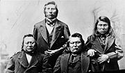
signed an executive order restoring a 15 miles (24.1 km) wide strip along the Canadian border to the public domain. Chief Moses and other delegates were taken to Washington, D.C. for a conference to resolve the outstanding issues.
Later developments
An agreement was reached on July 7, 1883 for the government to purchase the entire Columbia Reservation from the Indians. Those families formerly assigned to the reservation were to be given the choice of moving to the Colville Reservation or taking allotments of one section (1 sq mi or 2.6 km²) of land each. By act of Congress on July 4, 1884, the entire reservation was restored to the public domain. On May 1, 1886 it was formally reopened for white settlement. The influx of settlers was so great that Okanogan County (roughly the same area as the Columbia Reservation) was split from Stevens County two years later.Chief Moses died in 1899 on the Colville Reservation. He was buried there, near Nespelem, Washington
Nespelem, Washington
Nespelem is a town in Okanogan County, Washington, United States. The population was 236 at the 2010 census. The town is located on the Colville Indian Reservation. The name Nespelem is derived from a local Indian term meaning "large flat meadow".-History:...
.
Chief Moses once asked a follower to count the grains of sand in a pile. "There are too many," said the man. "It is the same with whites," replied Moses, "There are too many."
Moses Lake
Moses Lake
Moses Lake is a lake and reservoir along the course of Crab Creek, in Washington state, USA.Moses Lake is part of the Columbia River basin, as Crab Creek is a tributary of the Columbia River....
, Moses Coulee
Moses Coulee
Moses Coulee cuts into the Waterville plateau in Douglas County, Washington. It is to the west of and roughly parallel to the more famous Grand Coulee...
, and the city of Moses Lake
Moses Lake, Washington
Moses Lake is a city in Grant County, Washington, United States. The population was 20,366 as of the 2010 census. Moses Lake is the largest city in Grant County.-Background:...
are named for Chief Moses. One of the two junior high schools in Moses Lake is also named for Chief Moses.