
Chewton Keynsham
Encyclopedia
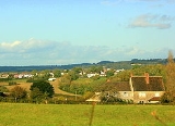
Chewton Keynsham is a small village on the River Chew
in the Chew Valley
, Somerset
. It is 7 miles from Bristol
, 7 miles from Bath, and 2 miles from Keynsham
.
The village lies on the Monarch's Way
long distance footpath.
Unitary Authority
which has wider responsibilities for services such as education, refuse, tourism etc. The village is a part of the North East Somerset
constituency and part of the South West England constituency
of the European Parliament.
and Compton Dando
), had 1,111 residents, living in 428 households, with an average age of 44.5 years. Of these 71% of residents describing their health as 'good', 21% of 16-74 year olds had no qualifications; and the area had an unemployment rate of 1.0% of all economically active people aged 16-74. In the Index of Multiple Deprivation 2004, it was ranked at 22,100 out of 32,482 wards in England, where 1 was the most deprived LSOA and 32,482 the least deprived.
tower, known locally as the Owl Tower, was built in the grounds in the late 18th century. It is a tall tapering square obelisk of coursed limestone. It has pointed-arched openings to east and west sides, producing a walk-through passage at ground floor level. There are diagonal buttresses with set-offs and small pointed-arched openings on each face and pyramidal cap. The carved owl to keystone on arched opening, probably gives the folly its name. The folly is also a Grade II listed building.
River Chew
The River Chew is a small river in England. It merges with the River Avon after forming the Chew Valley.The spring from which the Chew rises is just upstream from Chewton Mendip. The river flows North West from Chewton Mendip through Litton, Chew Valley Lake, Chew Stoke, Chew Magna and Stanton Drew...
in the Chew Valley
Chew Valley
The Chew Valley is an area in North Somerset, England, named after the River Chew, which rises at Chewton Mendip, and joins the River Avon at Keynsham...
, Somerset
Somerset
The ceremonial and non-metropolitan county of Somerset in South West England borders Bristol and Gloucestershire to the north, Wiltshire to the east, Dorset to the south-east, and Devon to the south-west. It is partly bounded to the north and west by the Bristol Channel and the estuary of the...
. It is 7 miles from Bristol
Bristol
Bristol is a city, unitary authority area and ceremonial county in South West England, with an estimated population of 433,100 for the unitary authority in 2009, and a surrounding Larger Urban Zone with an estimated 1,070,000 residents in 2007...
, 7 miles from Bath, and 2 miles from Keynsham
Keynsham
Keynsham is a town and civil parish between Bristol and Bath in Somerset, south-west England. It has a population of 15,533.It was listed in the Domesday Book as Cainesham, which is believed to mean the home of Saint Keyne....
.
The village lies on the Monarch's Way
Monarch's Way
The Monarch's Way is a long-distance footpath in England that approximates the escape route taken by King Charles II in 1651 after being defeated in the Battle of Worcester.Most of the footpath is waymarked...
long distance footpath.
Government and politics
Chewton Keynsham is part of the Farmborough Ward which is represented by one councillor on the Bath and North East SomersetBath and North East Somerset
Bath and North East Somerset is a unitary authority that was created on 1 April 1996 following the abolition of the County of Avon. It is part of the Ceremonial county of Somerset...
Unitary Authority
Unitary authority
A unitary authority is a type of local authority that has a single tier and is responsible for all local government functions within its area or performs additional functions which elsewhere in the relevant country are usually performed by national government or a higher level of sub-national...
which has wider responsibilities for services such as education, refuse, tourism etc. The village is a part of the North East Somerset
North East Somerset (UK Parliament constituency)
North East Somerset is a county constituency created by the Boundary Commission for England as the successor seat to the Wansdyke Parliamentary Seat. It came into being at the 2010 general election.- Boundaries :...
constituency and part of the South West England constituency
South West England (European Parliament constituency)
South West England is a constituency of the European Parliament. For 2009 it elects 6 MEPs using the d'Hondt method of party-list proportional representation, reduced from 7 in 2004.-Boundaries:...
of the European Parliament.
Demographics
According to the 2001 Census, the Farmborough Ward (which includes WoollardWoollard
Woollard is a small village on the River Chew in the Chew Valley in England. It is in the District of Bath and North East Somerset and the ceremonial county of Somerset, and is from Bristol, from Bath, and from Keynsham....
and Compton Dando
Compton Dando
Compton Dando is a small village and civil parish on the River Chew in the Chew Valley in England. It is in the District of Bath and North East Somerset and ceremonial county of Somerset, and lies from Bristol, from Bath, and from Keynsham...
), had 1,111 residents, living in 428 households, with an average age of 44.5 years. Of these 71% of residents describing their health as 'good', 21% of 16-74 year olds had no qualifications; and the area had an unemployment rate of 1.0% of all economically active people aged 16-74. In the Index of Multiple Deprivation 2004, it was ranked at 22,100 out of 32,482 wards in England, where 1 was the most deprived LSOA and 32,482 the least deprived.
Chewton Place
Chewton Place is a Grade II listed building was formerly a large detached house, but is now used as a conference centre. It was built about 1762 and extended c. 1786. It was extensively remodelled in 1860–70 and restored in 1968 after flood damage and further extended in 1987–88. A follyFolly
In architecture, a folly is a building constructed primarily for decoration, but either suggesting by its appearance some other purpose, or merely so extravagant that it transcends the normal range of garden ornaments or other class of building to which it belongs...
tower, known locally as the Owl Tower, was built in the grounds in the late 18th century. It is a tall tapering square obelisk of coursed limestone. It has pointed-arched openings to east and west sides, producing a walk-through passage at ground floor level. There are diagonal buttresses with set-offs and small pointed-arched openings on each face and pyramidal cap. The carved owl to keystone on arched opening, probably gives the folly its name. The folly is also a Grade II listed building.