
Cheddar Complex
Encyclopedia
The Cheddar Complex is a 441.3 hectare
(1090.5 acre) biological Site of Special Scientific Interest near Cheddar
around the Cheddar Gorge and north east to Charterhouse
in the Mendip Hills
, Somerset
, notified in 1952.
This is a very large area which includes 4 SSSIs formerly known as Cheddar Gorge SSSI, August Hole/Longwood Swallet SSSI, GB Cavern Charterhouse SSSI and Charterhouse on-Mendip SSSI. It is part owned by the National Trust
and part managed by the Somerset Wildlife Trust
.
and dense and scattered scrub. Four nationally rare plants are present, including Little Robin Geranium purpureum, Cheddar Pink Dianthus gratianopolitanus and Cheddar Bedstraw Galium fleurotii, two of which are endemic to the Cheddar area, as well as fifteen nationally scarce species.
, caves and vertebrate
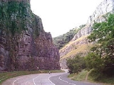
palaeontology and comprises four single interest localities. Cheddar Gorge is Britain’s largest gorge and probably the country’s best known limestone
feature. It is a spectacular fluvial
feature with a geomorphic history extending back 2 million years and encompassing the major environmental changes of the Pleistocene
period. Cheddar Caves contain both active and fossil
systems. The active cave system is one of the most heavily studied karst systems in Britain with reference to the conduit and diffuse flow characteristics of its hydrology
. Charterhouse
Caves include four major swallet caves that provide an indisputable record of Pleistocene
landform development in the Mendips and surrounding area. Sun Hole Cave provides a varied fauna radiocarbon-dated to the end of the Late Devensian Cold Stage.
Several types of limestone including Clifton Down Limestone, Cheddar Limestone and Cheddar Oolite are visible in the Gorge and surrounding areas with pale grey Burrington Oolite outcroping around Black Rock Gate.
The Charterhouse area is of great importance as the finest remaining example of the unique Lead orefields of the Mendips. The surface features derived from lead working from pre-Roman times up to the nineteenth century are extremely well preserved.
. These include: Black Rock, Bubworth Acres, GB Gruffy, Long Wood, Mascall's Wood, Middledown, Ubley Warren and Velvet Bottom.
The Black Rock reserve covers 181 acres (73.2 ha) of woodland, limestone grassland, conifers and an abandoned quarry. Long Wood covers 47 acres (19 ha) of ancient woodland
and includes Longwood Swallet
. It was historically the property of the Carthusian
monks of Witham Charterhouse
. In Roman times Velvet Bottom was mined for lead and the remains of circular buddle pits which were used to wash lead ore and settling beds can still be seen. Heaps of black shiny slag
are the remains from re-smelting of the lead. It now consists of rough grassland, with areas of woodland and shrubs. GB Gruffy includes 17 acres (6.9 ha) of neutral to acid species-rich
grassland which overlies the GB Cave
system. The 86 acres (34.8 ha) of Ubley Warren are another site deeply affected by the lead mining in the area which lasted until the 19th century.
Hectare
The hectare is a metric unit of area defined as 10,000 square metres , and primarily used in the measurement of land. In 1795, when the metric system was introduced, the are was defined as being 100 square metres and the hectare was thus 100 ares or 1/100 km2...
(1090.5 acre) biological Site of Special Scientific Interest near Cheddar
Cheddar
Cheddar is a large village and civil parish in the Sedgemoor district of the English county of Somerset. It is situated on the southern edge of the Mendip Hills, north-west of Wells. The civil parish includes the hamlets of Nyland and Bradley Cross...
around the Cheddar Gorge and north east to Charterhouse
Charterhouse, Somerset
Charterhouse, also known as Charterhouse-on-Mendip, is a hamlet in the Mendip Hills Area of Outstanding Natural Beauty in the English county of Somerset...
in the Mendip Hills
Mendip Hills
The Mendip Hills is a range of limestone hills to the south of Bristol and Bath in Somerset, England. Running east to west between Weston-super-Mare and Frome, the hills overlook the Somerset Levels to the south and the Avon Valley to the north...
, Somerset
Somerset
The ceremonial and non-metropolitan county of Somerset in South West England borders Bristol and Gloucestershire to the north, Wiltshire to the east, Dorset to the south-east, and Devon to the south-west. It is partly bounded to the north and west by the Bristol Channel and the estuary of the...
, notified in 1952.
This is a very large area which includes 4 SSSIs formerly known as Cheddar Gorge SSSI, August Hole/Longwood Swallet SSSI, GB Cavern Charterhouse SSSI and Charterhouse on-Mendip SSSI. It is part owned by the National Trust
National Trust for Places of Historic Interest or Natural Beauty
The National Trust for Places of Historic Interest or Natural Beauty, usually known as the National Trust, is a conservation organisation in England, Wales and Northern Ireland...
and part managed by the Somerset Wildlife Trust
Somerset Wildlife Trust
Somerset Wildlife Trust is a wildlife trust covering the county of Somerset, England.The trust, which was established in 1964, aims to safeguard the county's wildlife and wild places for this and future generations and manages almost 80 nature reserves. Examples include Fyne Court, Westhay Moor,...
.
Biological
The Cheddar Complex supports a wide range of semi-natural habitats which includes unimproved grassland, calcareous dry dwarf-shrub heath, semi-natural broadleaved woodlandAncient woodland
Ancient woodland is a term used in the United Kingdom to refer specifically to woodland that has existed continuously since 1600 or before in England and Wales . Before those dates, planting of new woodland was uncommon, so a wood present in 1600 was likely to have developed naturally...
and dense and scattered scrub. Four nationally rare plants are present, including Little Robin Geranium purpureum, Cheddar Pink Dianthus gratianopolitanus and Cheddar Bedstraw Galium fleurotii, two of which are endemic to the Cheddar area, as well as fifteen nationally scarce species.
Geological
This site is important for karstKARST
Kilometer-square Area Radio Synthesis Telescope is a Chinese telescope project to which FAST is a forerunner. KARST is a set of large spherical reflectors on karst landforms, which are bowlshaped limestone sinkholes named after the Kras region in Slovenia and Northern Italy. It will consist of...
, caves and vertebrate
Vertebrate
Vertebrates are animals that are members of the subphylum Vertebrata . Vertebrates are the largest group of chordates, with currently about 58,000 species described. Vertebrates include the jawless fishes, bony fishes, sharks and rays, amphibians, reptiles, mammals, and birds...
palaeontology and comprises four single interest localities. Cheddar Gorge is Britain’s largest gorge and probably the country’s best known limestone
Limestone
Limestone is a sedimentary rock composed largely of the minerals calcite and aragonite, which are different crystal forms of calcium carbonate . Many limestones are composed from skeletal fragments of marine organisms such as coral or foraminifera....
feature. It is a spectacular fluvial
Fluvial
Fluvial is used in geography and Earth science to refer to the processes associated with rivers and streams and the deposits and landforms created by them...
feature with a geomorphic history extending back 2 million years and encompassing the major environmental changes of the Pleistocene
Pleistocene
The Pleistocene is the epoch from 2,588,000 to 11,700 years BP that spans the world's recent period of repeated glaciations. The name pleistocene is derived from the Greek and ....
period. Cheddar Caves contain both active and fossil
Fossil
Fossils are the preserved remains or traces of animals , plants, and other organisms from the remote past...
systems. The active cave system is one of the most heavily studied karst systems in Britain with reference to the conduit and diffuse flow characteristics of its hydrology
Hydrology
Hydrology is the study of the movement, distribution, and quality of water on Earth and other planets, including the hydrologic cycle, water resources and environmental watershed sustainability...
. Charterhouse
Charterhouse, Somerset
Charterhouse, also known as Charterhouse-on-Mendip, is a hamlet in the Mendip Hills Area of Outstanding Natural Beauty in the English county of Somerset...
Caves include four major swallet caves that provide an indisputable record of Pleistocene
Pleistocene
The Pleistocene is the epoch from 2,588,000 to 11,700 years BP that spans the world's recent period of repeated glaciations. The name pleistocene is derived from the Greek and ....
landform development in the Mendips and surrounding area. Sun Hole Cave provides a varied fauna radiocarbon-dated to the end of the Late Devensian Cold Stage.
Several types of limestone including Clifton Down Limestone, Cheddar Limestone and Cheddar Oolite are visible in the Gorge and surrounding areas with pale grey Burrington Oolite outcroping around Black Rock Gate.
The Charterhouse area is of great importance as the finest remaining example of the unique Lead orefields of the Mendips. The surface features derived from lead working from pre-Roman times up to the nineteenth century are extremely well preserved.
Somerset Wildlife Trust Reserves
The area includes several nature reserves run by the Somerset Wildlife TrustSomerset Wildlife Trust
Somerset Wildlife Trust is a wildlife trust covering the county of Somerset, England.The trust, which was established in 1964, aims to safeguard the county's wildlife and wild places for this and future generations and manages almost 80 nature reserves. Examples include Fyne Court, Westhay Moor,...
. These include: Black Rock, Bubworth Acres, GB Gruffy, Long Wood, Mascall's Wood, Middledown, Ubley Warren and Velvet Bottom.
The Black Rock reserve covers 181 acres (73.2 ha) of woodland, limestone grassland, conifers and an abandoned quarry. Long Wood covers 47 acres (19 ha) of ancient woodland
Ancient woodland
Ancient woodland is a term used in the United Kingdom to refer specifically to woodland that has existed continuously since 1600 or before in England and Wales . Before those dates, planting of new woodland was uncommon, so a wood present in 1600 was likely to have developed naturally...
and includes Longwood Swallet
Longwood Swallet
Longwood Swallet is a cave near Charterhouse, in the carboniferous limestone of the Mendip Hills, in Somerset, England. The cave is part of the Cheddar Complex SSSI and connected to August Hole.It is 1.65 km in length and reaches a depth of 175m....
. It was historically the property of the Carthusian
Carthusian
The Carthusian Order, also called the Order of St. Bruno, is a Roman Catholic religious order of enclosed monastics. The order was founded by Saint Bruno of Cologne in 1084 and includes both monks and nuns...
monks of Witham Charterhouse
Witham Charterhouse
Witham Charterhouse was the earliest of the ten medieval Carthusian houses in England.-History:It was established at Witham Friary, Somerset in 1178/1179 from a founding party led by a monk called Narbert from the Grande Chartreuse...
. In Roman times Velvet Bottom was mined for lead and the remains of circular buddle pits which were used to wash lead ore and settling beds can still be seen. Heaps of black shiny slag
Slag
Slag is a partially vitreous by-product of smelting ore to separate the metal fraction from the unwanted fraction. It can usually be considered to be a mixture of metal oxides and silicon dioxide. However, slags can contain metal sulfides and metal atoms in the elemental form...
are the remains from re-smelting of the lead. It now consists of rough grassland, with areas of woodland and shrubs. GB Gruffy includes 17 acres (6.9 ha) of neutral to acid species-rich
grassland which overlies the GB Cave
GB Cave
GB Cave is a cave between Charterhouse and Shipham in the limestone of the Mendip Hills, in Somerset, England, and is close to Charterhouse Cave, the deepest in the region....
system. The 86 acres (34.8 ha) of Ubley Warren are another site deeply affected by the lead mining in the area which lasted until the 19th century.
See also
- List of Sites of Special Scientific Interest in Somerset
- Caves of the Mendip HillsCaves of the Mendip HillsThe Caves of the Mendip Hills are formed by the particular geology of the Mendip Hills, with large areas of limestone worn away by water makes it a national centre for caving. The hills conceal the largest underground river system in Britain.- Geology :...