

Chandalar River
Encyclopedia
River
A river is a natural watercourse, usually freshwater, flowing towards an ocean, a lake, a sea, or another river. In a few cases, a river simply flows into the ground or dries up completely before reaching another body of water. Small rivers may also be called by several other names, including...
in Alaska
Alaska
Alaska is the largest state in the United States by area. It is situated in the northwest extremity of the North American continent, with Canada to the east, the Arctic Ocean to the north, and the Pacific Ocean to the west and south, with Russia further west across the Bering Strait...
. Its peak flow recorded by the USGS
United States Geological Survey
The United States Geological Survey is a scientific agency of the United States government. The scientists of the USGS study the landscape of the United States, its natural resources, and the natural hazards that threaten it. The organization has four major science disciplines, concerning biology,...
was 62,800 cubic feet per second ( 1,780,000 liters per second), on June 9, 1968. http://nwis.waterdata.usgs.gov/ak/nwis/peak?site_no=15389500&agency_cd=USGS&format=html
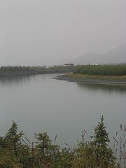
The Chandalar River is in the northern interior of the state of Alaska. It flows into the Yukon River less than 50 miles (80.5 km) west of Fort Yukon, Alaska
Fort Yukon, Alaska
As of the census of 2000, there were 595 people, 225 households, and 137 families residing in the city. The population density was 85.0 people per square mile . There were 317 housing units at an average density of 45.3 per square mile...
.
The North Fork of the Chandalar River begins near Atigun Pass
Atigun Pass
Atigun Pass, elevation , is a high mountain pass across the Brooks Range in Alaska, located at the head of the Dietrich River.. It is where the Dalton Highway crosses the Continental Divide , and is the highest pass in Alaska that is maintained throughout the year. Atigun is the only pass in the...
in the Brooks Range
Brooks Range
The Brooks Range is a mountain range in far northern North America. It stretches from west to east across northern Alaska and into Canada's Yukon Territory, a total distance of about 1100 km . The mountains top out at over 2,700 m . The range is believed to be approximately 126 million years old...
. At these headwaters of the Chandalar River is a flat valley known as Chandalar shelf just east of the Dalton Highway
Dalton Highway
The James W. Dalton Highway, usually Dalton Highway is a 414-mile road in Alaska. It begins at the Elliott Highway, north of Fairbanks, and ends at Deadhorse near the Arctic Ocean and the Prudhoe Bay oil fields...
, where caribou are known to winter.
The longer East Fork has its headwaters near the Romanzof Mountains in the eastern Brooks Range. From there, it flows down past Arctic Village
Arctic Village, Alaska
Arctic Village is an unincorporated Native American village and a census-designated place in Yukon-Koyukuk Census Area, Alaska, United States. As of the 2000 census, the population of the CDP was 152. The village is located in the large Gwitch'in speaking region of Alaska, and the local dialect...
, then joins the North Fork and continues past the village of Venetie to the Yukon River
Yukon River
The Yukon River is a major watercourse of northwestern North America. The source of the river is located in British Columbia, Canada. The next portion lies in, and gives its name to Yukon Territory. The lower half of the river lies in the U.S. state of Alaska. The river is long and empties into...
.
External links
- http://chamorrobible.org/gpw/gpw-20060825.htmChandalar River Valley Mountain, north of Arctic VillageArctic VillageArctic Village may refer to:*Arctic Village, Alaska*Arctic Village *China's Arctic village...
]