

Cave Dale
Encyclopedia
Limestone
Limestone is a sedimentary rock composed largely of the minerals calcite and aragonite, which are different crystal forms of calcium carbonate . Many limestones are composed from skeletal fragments of marine organisms such as coral or foraminifera....
valley in the Derbyshire
Derbyshire
Derbyshire is a county in the East Midlands of England. A substantial portion of the Peak District National Park lies within Derbyshire. The northern part of Derbyshire overlaps with the Pennines, a famous chain of hills and mountains. The county contains within its boundary of approx...
Peak District
Peak District
The Peak District is an upland area in central and northern England, lying mainly in northern Derbyshire, but also covering parts of Cheshire, Greater Manchester, Staffordshire, and South and West Yorkshire....
, England
England
England is a country that is part of the United Kingdom. It shares land borders with Scotland to the north and Wales to the west; the Irish Sea is to the north west, the Celtic Sea to the south west, with the North Sea to the east and the English Channel to the south separating it from continental...
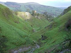
. It is located at grid reference . The northern end of the dale starts at the village of Castleton where the valley sides are almost perpendicular and over 50 metres in height. The dale rises gently after leaving Castleton for approximately 200 metres before becoming steeper culminating in a fine viewpoint down the dale taking in Peveril Castle
Peveril Castle
Peveril Castle is a medieval building overlooking the village of Castleton in the English county of Derbyshire. Its site provides views across the Hope Valley and Cave Dale. The castle is named after its founder, William Peveril, who held lands in Nottinghamshire and Derbyshire on behalf of the king...
with Lose Hill
Lose Hill
Lose Hill lies in the Derbyshire Peak District. It is the south-west corner of the parish of Edale and the end of the Great Ridge that runs from Rushup Edge to the west .Local access activist G. H. B...
behind (see picture). After the viewpoint the dale swings west and levels out with gentle gradients, becoming just a shallow depression as it peters out onto the open pastureland between Castleton and Chapel-en-le-Frith
Chapel-en-le-Frith
Chapel-en-le-Frith is a small town in Derbyshire, England, on the edge of the Peak District near the border with Cheshire, from Manchester. Dubbed "The Capital of the Peak District", the settlement was established by the Normans in the 12th century, originally as a hunting lodge within the Forest...
.
Cave Dale was initially formed by glacial
Glacier
A glacier is a large persistent body of ice that forms where the accumulation of snow exceeds its ablation over many years, often centuries. At least 0.1 km² in area and 50 m thick, but often much larger, a glacier slowly deforms and flows due to stresses induced by its weight...
meltwater carving a deep narrow valley in the local soluble limestone. The river then found a route underground leaving a dry valley with cave
Cave
A cave or cavern is a natural underground space large enough for a human to enter. The term applies to natural cavities some part of which is in total darkness. The word cave also includes smaller spaces like rock shelters, sea caves, and grottos.Speleology is the science of exploration and study...
rns underneath. Later on the caverns below Cave Dale collapsed making the valley even deeper and gorge-like at the northern end. The Castleton entrance to Cave Dale had a narrow natural arch
Natural arch
A natural arch or natural bridge is a natural geological formation where a rock arch forms, with an opening underneath. Most natural arches form as a narrow ridge, walled by cliffs, become narrower from erosion, with a softer rock stratum under the cliff-forming stratum gradually eroding out until...
as recently as 200 years ago, a relic of the roof collapse. The lower slopes of the dale have large amounts of scree
Scree
Scree, also called talus, is a term given to an accumulation of broken rock fragments at the base of crags, mountain cliffs, or valley shoulders. Landforms associated with these materials are sometimes called scree slopes or talus piles...
, frost on the higher limestone cliffs having caused the rock to shatter. Halfway up the valley is an outcrop of basaltic lava
Basalt
Basalt is a common extrusive volcanic rock. It is usually grey to black and fine-grained due to rapid cooling of lava at the surface of a planet. It may be porphyritic containing larger crystals in a fine matrix, or vesicular, or frothy scoria. Unweathered basalt is black or grey...
with a few small columns.
Limestone Way
The Limestone Way is a long-distance bridleway in Derbyshire, England. It runs through the White Peak of the Peak District National Park, from Castleton south east to Rocester over the county boundary in Staffordshire. It originally ran to Matlock, but was diverted to its current, longer route to...
footpath which travels 80 kilometres from Castleton to Rocester
Rocester
Rocester is a village and civil parish in the East Staffordshire district of Staffordshire, England. Its name is spelt Rowcestre in the Domesday Book.-Geography:...
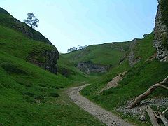
in Staffordshire. Cave Dale is accessed through a narrow rocky opening almost from the centre of Castleton and Peveril Castle is seen high up on the almost vertical western slopes. The Normans
Normans
The Normans were the people who gave their name to Normandy, a region in northern France. They were descended from Norse Viking conquerors of the territory and the native population of Frankish and Gallo-Roman stock...
chose this site because the steep sides of Cave Dale gave a natural defence and good lookout.
The chambers and caves of Peak Cavern
Peak Cavern
The Peak Cavern, also known as the Devil's Arse , is one of the four show caves in Castleton, Derbyshire, England...
run directly below Cave Dale and any small streams in the dale quickly disappear into the ground down limestone fissures and into the caverns beneath. Mineral veins can also be seen within the limestone of the dale. The cliffs at the northern end of Cave Dale are used by rock climbers
Climbing
Climbing is the activity of using one's hands and feet to ascend a steep object. It is done both for recreation and professionally, as part of activities such as maintenance of a structure, or military operations.Climbing activities include:* Bouldering: Ascending boulders or small...
and there are several routes in the Very Severe category. There are several small caves or old lead
Lead
Lead is a main-group element in the carbon group with the symbol Pb and atomic number 82. Lead is a soft, malleable poor metal. It is also counted as one of the heavy metals. Metallic lead has a bluish-white color after being freshly cut, but it soon tarnishes to a dull grayish color when exposed...
mines within the dale's limestone walls, with one being larger than the rest with bars preventing access. Cave Dale's steep north-facing grassy slopes are damp and bryophyte
Bryophyte
Bryophyte is a traditional name used to refer to all embryophytes that do not have true vascular tissue and are therefore called 'non-vascular plants'. Some bryophytes do have specialized tissues for the transport of water; however since these do not contain lignin, they are not considered to be...
-rich and are dominated by oat grass (Trisetum
Trisetum
Trisetum is a genus of grass in the Poaceae family.-Species:* There are about 75 species, listed in List of Trisetum species.-External links:*...
flavescent) and Sheep's Fescue
Sheep's Fescue
Sheep's Fescue or Sheep Fescue is a species of grass.-General Description:It is a perennial plant sometimes found in acidic ground, for example in the Portlethen Moss, Scotland and mountain pasture, throughout Europe and eastwards across much of Asia; it has also been introduced to North...
(Festuca ovina). Lesser meadow-rue (Thalictrum
Thalictrum
Thalictrum is a genus of 120-200 species of herbaceous perennial flowering plants in the buttercup family native mostly to temperate regions....
minus) grows extensively on ledges in the dale.
At the southwestern extremity of the dale as it merges into the moorland between Castleton and Peak Forest
Peak Forest
Peak Forest is a small village on the main road the from Chapel-en-le-Frith to Chesterfield in England.The village grew from the earlier settlement of Dam at the conjunction of Perrydale and Damdale. There is an inn, a village shop and a Primary School...
are the remains of several old lead
Lead
Lead is a main-group element in the carbon group with the symbol Pb and atomic number 82. Lead is a soft, malleable poor metal. It is also counted as one of the heavy metals. Metallic lead has a bluish-white color after being freshly cut, but it soon tarnishes to a dull grayish color when exposed...
mines. The Hazard Mine lies at grid reference , and was one of the major mines of the area. Over 5000 tonnes of lead ore were mined and the main shaft goes down 700 feet. The Hollandtwine Mine lies 250 metres to the east. Drainage from both mines went directly into Peak Cavern.
In 1983 Cave Dale was the scene of the murder of a 21-year-old Manchester Polytechnic student, Susan Renhard
Susan Renhard
Susan Renhard was a student murdered in Cave Dale near Castleton, Derbyshire in Derbyshire 1983. Norman Hugh Smith, a young student, later admitted to her sexual assault but denied strangling her. He is thought to still be in prison.-Background:...
. Norman Smith, a local 17-year-old youth, was subsequently jailed for life at Nottingham Crown Court
Nottingham Crown Court
Nottingham Crown Court, or more formally the High Court of Justice and Crown Court, Nottingham is a Crown Court and High Court of Justice in Nottingham, England.-Description:...
in 1984.
Cave Dale features in the 2008 film The Other Boleyn Girl.