
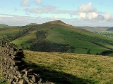
Lose Hill
Encyclopedia
Lose Hill lies in the Derbyshire
Peak District
. It is the south-west corner of the parish of Edale
and the end of the Great Ridge
that runs from Rushup Edge
to the west (over Mam Tor
, Hollins Cross and Back Tor).
Local access activist G. H. B. Ward
was given an area of Lose Hill by the Sheffield and District Federation of the Ramblers Association in 1945, which was named Ward's Piece; he subsequently presented this to the National Trust
.
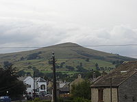 Its counterpart is Win Hill
, lying to its east.
Lose Hill gets its name from the Battle of Win Hill and Lose Hill in 626. Prince Cwichelm and his father, King Cynegils of Wessex, possibly with the aid of King Penda of Mercia, gathered their forces on neighbouring Lose Hill and marched on the Northumbrians based on Win Hill. Despite their superior numbers, Wessex was defeated by the Northumbrians building a wall and rolling boulders down upon them.
Derbyshire
Derbyshire is a county in the East Midlands of England. A substantial portion of the Peak District National Park lies within Derbyshire. The northern part of Derbyshire overlaps with the Pennines, a famous chain of hills and mountains. The county contains within its boundary of approx...
Peak District
Peak District
The Peak District is an upland area in central and northern England, lying mainly in northern Derbyshire, but also covering parts of Cheshire, Greater Manchester, Staffordshire, and South and West Yorkshire....
. It is the south-west corner of the parish of Edale
Edale
Edale is a small Derbyshire village and Civil parish in the Peak District, in the Midlands of England. The Parish of Edale,area ,is in the Borough of High Peak....
and the end of the Great Ridge
Great Ridge
The Great Ridge, is a ridge separating the vales of Edale and Castleton. It covers approximately 3 kilometres from Mam Tor at the western end of the ridge to Lose Hill at the eastern end, the lowest point being Hollins Cross, where the most often used path up to, or over the ridge, runs.A path runs...
that runs from Rushup Edge
Rushup Edge
Rushup Edge is a ridge in the Derbyshire Peak District of England. The ridge's highest point is Lord's Seat at , while Mam Tor lies at its eastern end, beyond which the Great Ridge runs.-References:...
to the west (over Mam Tor
Mam Tor
Mam Tor is a hill near Castleton in the High Peak of Derbyshire, England. Its name literally translates as Heights of the Mother and it is also known as the Shivering Mountain on account of the instability of its lower shale layers...
, Hollins Cross and Back Tor).
Local access activist G. H. B. Ward
G. H. B. Ward
George Herbert Bridges Ward, known as G. H. B. Ward or Bert Ward was an activist for walkers' rights and a Labour Party politician....
was given an area of Lose Hill by the Sheffield and District Federation of the Ramblers Association in 1945, which was named Ward's Piece; he subsequently presented this to the National Trust
National Trust for Places of Historic Interest or Natural Beauty
The National Trust for Places of Historic Interest or Natural Beauty, usually known as the National Trust, is a conservation organisation in England, Wales and Northern Ireland...
.
Win Hill
Win Hill lies north west of Bamford in the Derbyshire Peak District of England. At , it is almost surrounded by the River Derwent to the east, River Noe to the south west and Ladybower Reservoir to the north, but a ridge running north west links it to Kinder Scout...
, lying to its east.
Lose Hill gets its name from the Battle of Win Hill and Lose Hill in 626. Prince Cwichelm and his father, King Cynegils of Wessex, possibly with the aid of King Penda of Mercia, gathered their forces on neighbouring Lose Hill and marched on the Northumbrians based on Win Hill. Despite their superior numbers, Wessex was defeated by the Northumbrians building a wall and rolling boulders down upon them.