
Catstye Cam
Encyclopedia
Catstye Cam is a fell
in the English
Lake District
. It is an outlier of Helvellyn
in the Eastern Fells
.
in his influential Pictorial Guide to the Lakeland Fells
. A third variant, 'Catchedicam', is also quoted by him. Other guidebooks such as Collins Landranger and Birkett follow Wainwright with 'Catstycam', although the maps of the Ordnance Survey
always use 'Catstye Cam'.
runs broadly north to south for about 7 miles, remaining above 2,000 ft (600 m) throughout its length. Helvellyn itself sits near the centre of this ridge and displays the characteristic form of many of these fells, namely smooth grassy slopes to the west and shattered rock to the east. Helvellyn sends out two eastward arête
s, razor thin ridges between deep mountain corrie
s. The southerly spur is Striding Edge, easily the most famous ridge in the district, and its northern partner is Swirral Edge. From the summit plateau of Helvellyn a rough slope drops to the start of Swirral Edge, and this narrow ridge curves gracefully down and then back up over half a mile, terminating at Catstye Cam.
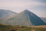
Taking on the classic mountain shape of a pyramid
, Catstye Cam draws the eye in any view where the overtopping bulk of Helvellyn is hidden behind. As Wainwright said "If Catstycam stood alone, remote from its fellows, it would be one of the finest peaks in Lakeland. It has nearly, but not quite, the perfect mountain form with true simplicity in its soaring lines, and a small pointed top, a real summit that falls away on all sides". Even with the connection to Helvellyn, Catstye Cam still has a prominence of over 200 ft due to the pronounced bow of Swirral Edge. High Spying How on Striding Edge, by comparison, is nothing but a rock turret, an independent peak in almost no-one's estimation.
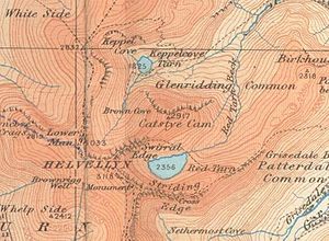 East of the summit the ridge declines quickly to Red Tarn Beck, whilst there is a third ridge to the north west, giving Catstye Cam a triangular plan. To the north, between the two descending ridges, is an area of crag. The other two faces are steep but smooth.
South of Catstye Cam, nestling between the encircling arms of Helvellyn's two edges, is Red Tarn
. This pool is named for the colour of the surrounding screes rather than its water, and contains brown trout and schelly, a fresh-water herring. The depth of Red Tarn is now about 80 ft, although in the mid-19th century is was dammed with boulders to increase capacity. This was carried out to provide additional water to the Greenside lead
mine in Glenridding, the water race still visible as it crosses the slope of Birkhouse Moor
.
A second tarn once existed in Brown Cove to the north at Catstye Cam, but this is now reduced to a couple of small pools widening the stream. Brown Cove Tarn was another creation of the Greenside mine, a stone faced dam being built in about 1860. The dam is still in place but water now leaks through the base, the extended tarn-bed a smooth patch of luxuriant turf. A water leat passing beneath the north face of Catstye Cam to Red Tarn Beck can still be traced although it is now in ruins. Water from Brown Cove and Red Tarn unites at the base of the east ridge to form Glenridding Beck, flowing on through the village to Ullswater
.
lapilli
-tuff
of the Helvellyn Formation.
. The view is extensive and even the looming Helvellyn only adds to the drama by showing its eastern face in close detail. Striding Edge is also seen in profile across Red Tarn, lines of pilgrims frequently queueing at the bottlenecks. By contrast Catstye Cam is often almost completely deserted.
Fell
“Fell” is a word used to refer to mountains, or certain types of mountainous landscape, in Scandinavia, the Isle of Man, and parts of northern England.- Etymology :...
in the English
England
England is a country that is part of the United Kingdom. It shares land borders with Scotland to the north and Wales to the west; the Irish Sea is to the north west, the Celtic Sea to the south west, with the North Sea to the east and the English Channel to the south separating it from continental...
Lake District
Lake District
The Lake District, also commonly known as The Lakes or Lakeland, is a mountainous region in North West England. A popular holiday destination, it is famous not only for its lakes and its mountains but also for its associations with the early 19th century poetry and writings of William Wordsworth...
. It is an outlier of Helvellyn
Helvellyn
Helvellyn is a mountain in the English Lake District, the apex of the Eastern Fells. At above sea level, it is the third highest peak in both the Lake District and England...
in the Eastern Fells
Eastern Fells
The Eastern Fells are a group of hills in the English Lake District. Centred on Helvellyn they primarily comprise a north south ridge running between Ullswater and Lakeland's Central Valley.-Partition of the Lakeland Fells:...
.
Name
The name of the fell is also given as 'Catstycam', a spelling preferred by Alfred WainwrightAlfred Wainwright
Alfred Wainwright MBE was a British fellwalker, guidebook author and illustrator. His seven-volume Pictorial Guide to the Lakeland Fells, published between 1955 and 1966 and consisting entirely of reproductions of his manuscript, has become the standard reference work to 214 of the fells of the...
in his influential Pictorial Guide to the Lakeland Fells
Pictorial Guide to the Lakeland Fells
A Pictorial Guide to the Lakeland Fells is a series of seven books by A. Wainwright, detailing the fells of the Lake District in northwest England...
. A third variant, 'Catchedicam', is also quoted by him. Other guidebooks such as Collins Landranger and Birkett follow Wainwright with 'Catstycam', although the maps of the Ordnance Survey
Ordnance Survey
Ordnance Survey , an executive agency and non-ministerial government department of the Government of the United Kingdom, is the national mapping agency for Great Britain, producing maps of Great Britain , and one of the world's largest producers of maps.The name reflects its creation together with...
always use 'Catstye Cam'.
Topography
The Helvellyn rangeHelvellyn range
Helvellyn range is the name given to a part of the Eastern Fells in the English Lake District, fell being the local word for hill. The name comes from Helvellyn, the highest point of the group....
runs broadly north to south for about 7 miles, remaining above 2,000 ft (600 m) throughout its length. Helvellyn itself sits near the centre of this ridge and displays the characteristic form of many of these fells, namely smooth grassy slopes to the west and shattered rock to the east. Helvellyn sends out two eastward arête
Arete
Areté is the term meaning "virtue" or "excellence", from Greek ἈρετήArete may also be used:*as a given name of persons or things:**Queen Arete , a character in Homer's Odyssey.***197 Arete, an asteroid....
s, razor thin ridges between deep mountain corrie
Cirque
Cirque may refer to:* Cirque, a geological formation* Makhtesh, an erosional landform found in the Negev desert of Israel and Sinai of Egypt*Cirque , an album by Biosphere* Cirque Corporation, a company that makes touchpads...
s. The southerly spur is Striding Edge, easily the most famous ridge in the district, and its northern partner is Swirral Edge. From the summit plateau of Helvellyn a rough slope drops to the start of Swirral Edge, and this narrow ridge curves gracefully down and then back up over half a mile, terminating at Catstye Cam.
Taking on the classic mountain shape of a pyramid
Pyramid
A pyramid is a structure whose outer surfaces are triangular and converge at a single point. The base of a pyramid can be trilateral, quadrilateral, or any polygon shape, meaning that a pyramid has at least three triangular surfaces...
, Catstye Cam draws the eye in any view where the overtopping bulk of Helvellyn is hidden behind. As Wainwright said "If Catstycam stood alone, remote from its fellows, it would be one of the finest peaks in Lakeland. It has nearly, but not quite, the perfect mountain form with true simplicity in its soaring lines, and a small pointed top, a real summit that falls away on all sides". Even with the connection to Helvellyn, Catstye Cam still has a prominence of over 200 ft due to the pronounced bow of Swirral Edge. High Spying How on Striding Edge, by comparison, is nothing but a rock turret, an independent peak in almost no-one's estimation.
South of Catstye Cam, nestling between the encircling arms of Helvellyn's two edges, is Red Tarn
Tarn (lake)
A tarn is a mountain lake or pool, formed in a cirque excavated by a glacier. A moraine may form a natural dam below a tarn. A corrie may be called a cirque.The word is derived from the Old Norse word tjörn meaning pond...
. This pool is named for the colour of the surrounding screes rather than its water, and contains brown trout and schelly, a fresh-water herring. The depth of Red Tarn is now about 80 ft, although in the mid-19th century is was dammed with boulders to increase capacity. This was carried out to provide additional water to the Greenside lead
Lead
Lead is a main-group element in the carbon group with the symbol Pb and atomic number 82. Lead is a soft, malleable poor metal. It is also counted as one of the heavy metals. Metallic lead has a bluish-white color after being freshly cut, but it soon tarnishes to a dull grayish color when exposed...
mine in Glenridding, the water race still visible as it crosses the slope of Birkhouse Moor
Birkhouse Moor
Birkhouse Moor is a fell in the English Lake District, an outlier of the Helvellyn range in the Eastern Fells. It is properly an eastern ridge of Helvellyn, but was treated as a separate fell by Alfred Wainwright in his Pictorial Guide to the Lakeland Fells...
.
A second tarn once existed in Brown Cove to the north at Catstye Cam, but this is now reduced to a couple of small pools widening the stream. Brown Cove Tarn was another creation of the Greenside mine, a stone faced dam being built in about 1860. The dam is still in place but water now leaks through the base, the extended tarn-bed a smooth patch of luxuriant turf. A water leat passing beneath the north face of Catstye Cam to Red Tarn Beck can still be traced although it is now in ruins. Water from Brown Cove and Red Tarn unites at the base of the east ridge to form Glenridding Beck, flowing on through the village to Ullswater
Ullswater
Ullswater is the second largest lake in the English Lake District, being approximately nine miles long and 0.75 miles wide with a maximum depth of slightly more than ....
.
Geology
The principal rock type is the daciticDacite
Dacite is an igneous, volcanic rock. It has an aphanitic to porphyritic texture and is intermediate in composition between andesite and rhyolite. The relative proportions of feldspars and quartz in dacite, and in many other volcanic rocks, are illustrated in the QAPF diagram...
lapilli
Lapilli
Lapilli is a size classification term for tephra, which is material that falls out of the air during a volcanic eruption or during some meteorite impacts. Lapilli means "little stones" in Latin. They are in some senses similar to ooids or pisoids in calcareous sediments.By definition lapilli range...
-tuff
Tuff
Tuff is a type of rock consisting of consolidated volcanic ash ejected from vents during a volcanic eruption. Tuff is sometimes called tufa, particularly when used as construction material, although tufa also refers to a quite different rock. Rock that contains greater than 50% tuff is considered...
of the Helvellyn Formation.
Summit and View
The summit of Catstye Cam is small and neat, bearing only a tiny cairnCairn
Cairn is a term used mainly in the English-speaking world for a man-made pile of stones. It comes from the or . Cairns are found all over the world in uplands, on moorland, on mountaintops, near waterways and on sea cliffs, and also in barren desert and tundra areas...
. The view is extensive and even the looming Helvellyn only adds to the drama by showing its eastern face in close detail. Striding Edge is also seen in profile across Red Tarn, lines of pilgrims frequently queueing at the bottlenecks. By contrast Catstye Cam is often almost completely deserted.