
Birkhouse Moor
Encyclopedia
Birkhouse Moor is a fell
in the English
Lake District
, an outlier of the Helvellyn range
in the Eastern Fells
. It is properly an eastern ridge of Helvellyn
, but was treated as a separate fell by Alfred Wainwright
in his Pictorial Guide to the Lakeland Fells
. That convention is followed here.
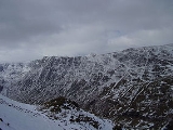
which provides the most famous fell-walking in the District. The ridge turns a little to the north at the rocky turret of High Spying How and then drops to a grassy saddle, known as Hole-in-the-Wall. North east of here the ridge broadens into a wide plateau, appearing in plan like a three taloned claw. This plateau, about a mile wide, is Birkhouse Moor. The three talons are the short spurs of Keldas, The Nab and the unnamed northern ridge.
To the south of the Striding Edge- Birkhouse Moor ridge runs the long valley of Grisedale, emptying into the head of Ullswater
. There are small pockets of mixed woodland on the lower slopes and above these the valley wall is steep sided with some outcropping rock.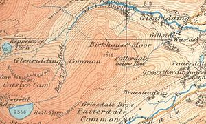 The northern side of Birkhouse Moor is bounded by the more complex Glenridding valley system. Glenridding Beck has three principal southern tributaries:- Mires Beck, Bleacove Beck and Red Tarn Beck. Mires Beck flows from Little Cove, a small corrie
separating Keldas and the Nab. Bleacove Beck empties Blea Cove, a short side valley between The Nab and the north ridge. Red Tarn Beck forms the western perimeter of Birkhouse Moor, draining the large tarn
of that name nestling beneath the summit of Helvellyn. There is more rock on this side, with Nab Crag rising above Blea Cove and extensive outcropping on all three ridges. There remains evidence on the Glenridding slopes of the former activities of Greenside Lead Mine. Several leats and pipelines can still be traced which once captured the water of these streams for industrial use.
Keldas is separated from the main body of Birkhouse Moor by a small depression containing Lanty's Tarn. This small waterbody gains its name from Lancelot Dobson, an earlier landowner. It was later bought by the owners of Patterdale Hall, the Marshall family, and extended by damming. In addition to fishing, the tarn was used as a source of ice in winter, and the ice house still stands nearby. The summit of Keldas is privately owned but public access is permitted. Standing above the head of Ullswater it provides superb views down the lake, with the 'Keldas Pines' giving an excellent foreground for pictures.
lapilli
-tuff
of the Helvellyn Formation. The overlying volcaniclastic sandstone
of the Deepdale Formation is revealed at Keldas.
Fell
“Fell” is a word used to refer to mountains, or certain types of mountainous landscape, in Scandinavia, the Isle of Man, and parts of northern England.- Etymology :...
in the English
England
England is a country that is part of the United Kingdom. It shares land borders with Scotland to the north and Wales to the west; the Irish Sea is to the north west, the Celtic Sea to the south west, with the North Sea to the east and the English Channel to the south separating it from continental...
Lake District
Lake District
The Lake District, also commonly known as The Lakes or Lakeland, is a mountainous region in North West England. A popular holiday destination, it is famous not only for its lakes and its mountains but also for its associations with the early 19th century poetry and writings of William Wordsworth...
, an outlier of the Helvellyn range
Helvellyn range
Helvellyn range is the name given to a part of the Eastern Fells in the English Lake District, fell being the local word for hill. The name comes from Helvellyn, the highest point of the group....
in the Eastern Fells
Eastern Fells
The Eastern Fells are a group of hills in the English Lake District. Centred on Helvellyn they primarily comprise a north south ridge running between Ullswater and Lakeland's Central Valley.-Partition of the Lakeland Fells:...
. It is properly an eastern ridge of Helvellyn
Helvellyn
Helvellyn is a mountain in the English Lake District, the apex of the Eastern Fells. At above sea level, it is the third highest peak in both the Lake District and England...
, but was treated as a separate fell by Alfred Wainwright
Alfred Wainwright
Alfred Wainwright MBE was a British fellwalker, guidebook author and illustrator. His seven-volume Pictorial Guide to the Lakeland Fells, published between 1955 and 1966 and consisting entirely of reproductions of his manuscript, has become the standard reference work to 214 of the fells of the...
in his Pictorial Guide to the Lakeland Fells
Pictorial Guide to the Lakeland Fells
A Pictorial Guide to the Lakeland Fells is a series of seven books by A. Wainwright, detailing the fells of the Lake District in northwest England...
. That convention is followed here.
Topography
Running east from the summit of Helvellyn is Striding Edge, a knife-edged arêteArete
Areté is the term meaning "virtue" or "excellence", from Greek ἈρετήArete may also be used:*as a given name of persons or things:**Queen Arete , a character in Homer's Odyssey.***197 Arete, an asteroid....
which provides the most famous fell-walking in the District. The ridge turns a little to the north at the rocky turret of High Spying How and then drops to a grassy saddle, known as Hole-in-the-Wall. North east of here the ridge broadens into a wide plateau, appearing in plan like a three taloned claw. This plateau, about a mile wide, is Birkhouse Moor. The three talons are the short spurs of Keldas, The Nab and the unnamed northern ridge.
To the south of the Striding Edge- Birkhouse Moor ridge runs the long valley of Grisedale, emptying into the head of Ullswater
Ullswater
Ullswater is the second largest lake in the English Lake District, being approximately nine miles long and 0.75 miles wide with a maximum depth of slightly more than ....
. There are small pockets of mixed woodland on the lower slopes and above these the valley wall is steep sided with some outcropping rock.
Cirque
Cirque may refer to:* Cirque, a geological formation* Makhtesh, an erosional landform found in the Negev desert of Israel and Sinai of Egypt*Cirque , an album by Biosphere* Cirque Corporation, a company that makes touchpads...
separating Keldas and the Nab. Bleacove Beck empties Blea Cove, a short side valley between The Nab and the north ridge. Red Tarn Beck forms the western perimeter of Birkhouse Moor, draining the large tarn
Tarn (lake)
A tarn is a mountain lake or pool, formed in a cirque excavated by a glacier. A moraine may form a natural dam below a tarn. A corrie may be called a cirque.The word is derived from the Old Norse word tjörn meaning pond...
of that name nestling beneath the summit of Helvellyn. There is more rock on this side, with Nab Crag rising above Blea Cove and extensive outcropping on all three ridges. There remains evidence on the Glenridding slopes of the former activities of Greenside Lead Mine. Several leats and pipelines can still be traced which once captured the water of these streams for industrial use.
Keldas is separated from the main body of Birkhouse Moor by a small depression containing Lanty's Tarn. This small waterbody gains its name from Lancelot Dobson, an earlier landowner. It was later bought by the owners of Patterdale Hall, the Marshall family, and extended by damming. In addition to fishing, the tarn was used as a source of ice in winter, and the ice house still stands nearby. The summit of Keldas is privately owned but public access is permitted. Standing above the head of Ullswater it provides superb views down the lake, with the 'Keldas Pines' giving an excellent foreground for pictures.
Geology
The summit area is composed of the daciticDacite
Dacite is an igneous, volcanic rock. It has an aphanitic to porphyritic texture and is intermediate in composition between andesite and rhyolite. The relative proportions of feldspars and quartz in dacite, and in many other volcanic rocks, are illustrated in the QAPF diagram...
lapilli
Lapilli
Lapilli is a size classification term for tephra, which is material that falls out of the air during a volcanic eruption or during some meteorite impacts. Lapilli means "little stones" in Latin. They are in some senses similar to ooids or pisoids in calcareous sediments.By definition lapilli range...
-tuff
Tuff
Tuff is a type of rock consisting of consolidated volcanic ash ejected from vents during a volcanic eruption. Tuff is sometimes called tufa, particularly when used as construction material, although tufa also refers to a quite different rock. Rock that contains greater than 50% tuff is considered...
of the Helvellyn Formation. The overlying volcaniclastic sandstone
Sandstone
Sandstone is a sedimentary rock composed mainly of sand-sized minerals or rock grains.Most sandstone is composed of quartz and/or feldspar because these are the most common minerals in the Earth's crust. Like sand, sandstone may be any colour, but the most common colours are tan, brown, yellow,...
of the Deepdale Formation is revealed at Keldas.