

Carnmenellis
Encyclopedia
Cornwall
Cornwall is a unitary authority and ceremonial county of England, within the United Kingdom. It is bordered to the north and west by the Celtic Sea, to the south by the English Channel, and to the east by the county of Devon, over the River Tamar. Cornwall has a population of , and covers an area of...
between Redruth
Redruth
Redruth is a town and civil parish traditionally in the Penwith Hundred in Cornwall, United Kingdom. It has a population of 12,352. Redruth lies approximately at the junction of the A393 and A3047 roads, on the route of the old London to Land's End trunk road , and is approximately west of...
, Helston
Helston
Helston is a town and civil parish in Cornwall, England, United Kingdom. It is situated at the northern end of the Lizard Peninsula approximately 12 miles east of Penzance and nine miles southwest of Falmouth. Helston is the most southerly town in the UK and is around further south than...
and Penryn
Penryn, Cornwall
Penryn is a civil parish and town in Cornwall, England, United Kingdom. It is situated on the Penryn River about one mile northwest of Falmouth...
. The hill itself is situated approximately three miles (5 km) south of Redruth.
Penmarth
Penmarth
Penmarth is a hamlet in Cornwall, United Kingdom. It is situated approximately four and a half miles west of Penryn and approximately four miles south of Redruth....
, a nearby village, is sometimes referred to locally as Carnmenellis.
The term 'Carnmenellis Granite' refers to the plateau
Plateau
In geology and earth science, a plateau , also called a high plain or tableland, is an area of highland, usually consisting of relatively flat terrain. A highly eroded plateau is called a dissected plateau...
of high ground in this area, one of five granite
Granite
Granite is a common and widely occurring type of intrusive, felsic, igneous rock. Granite usually has a medium- to coarse-grained texture. Occasionally some individual crystals are larger than the groundmass, in which case the texture is known as porphyritic. A granitic rock with a porphyritic...
pluton
Pluton
A pluton in geology is a body of intrusive igneous rock that crystallized from magma slowly cooling below the surface of the Earth. Plutons include batholiths, dikes, sills, laccoliths, lopoliths, and other igneous bodies...
s in Cornwall that make up part of the Cornubian batholith
Cornubian batholith
The Cornubian batholith refers to the group of associated granite intrusions which underlie the south-western peninsula of Great Britain. The main exposed masses of the batholith are seen at Dartmoor, Bodmin Moor, St Austell, Carnmenellis, Land's End and the Isles of Scilly. It formed during the...
(see also Geology of Cornwall
Geology of Cornwall
The Geology of Cornwall is dominated by its granite backbone, part of the Cornubian batholith, formed during the Variscan orogeny. Around this is an extensive metamorphic aureole formed in the mainly Devonian slates that make up most of the rest of the county...
).
Carnmenellis was also the name of a former ecclesiastical parish created in 1846 from part of Wendron
Wendron
Wendron is a village and civil parish in Cornwall, United Kingdom. It is situated three miles north of Helston.The Revd G. H. Doble served for almost twenty years as the Vicar of Wendron . Langdon recorded the existence of eight stone crosses in the parish, including two at Merther Uny...
parish. Initially, the parish included the area which later became the parish of Pencoys. Today, most of the Carmenellis area is in Stithians
Stithians
Stithians is a village and civil parish in Cornwall, England, in the United Kingdom. It lies in the centre of the triangle bounded by Redruth, Helston and Falmouth. Its population is 2,004....
civil parish
Civil parish
In England, a civil parish is a territorial designation and, where they are found, the lowest tier of local government below districts and counties...
.
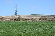
The summit of Carnmenellis Hill is located at OS grid reference:) and is 252 metres (828 feet) above sea level. A microwave
Microwave
Microwaves, a subset of radio waves, have wavelengths ranging from as long as one meter to as short as one millimeter, or equivalently, with frequencies between 300 MHz and 300 GHz. This broad definition includes both UHF and EHF , and various sources use different boundaries...
transmitting and receiving tower on the summit is used for telephone
Telephone
The telephone , colloquially referred to as a phone, is a telecommunications device that transmits and receives sounds, usually the human voice. Telephones are a point-to-point communication system whose most basic function is to allow two people separated by large distances to talk to each other...
and computer
Computer
A computer is a programmable machine designed to sequentially and automatically carry out a sequence of arithmetic or logical operations. The particular sequence of operations can be changed readily, allowing the computer to solve more than one kind of problem...
connections as well as other data and television and radio broadcasting
Broadcasting
Broadcasting is the distribution of audio and video content to a dispersed audience via any audio visual medium. Receiving parties may include the general public or a relatively large subset of thereof...
links. It is maintained by BT
BT Group
BT Group plc is a global telecommunications services company headquartered in London, United Kingdom. It is one of the largest telecommunications services companies in the world and has operations in more than 170 countries. Through its BT Global Services division it is a major supplier of...
.
A number of Iron Age
Iron Age
The Iron Age is the archaeological period generally occurring after the Bronze Age, marked by the prevalent use of iron. The early period of the age is characterized by the widespread use of iron or steel. The adoption of such material coincided with other changes in society, including differing...
fortifications surround the hill, but little archaeological research has been done on the site.
There is no public right of way across the summit
Summit (topography)
In topography, a summit is a point on a surface that is higher in elevation than all points immediately adjacent to it. Mathematically, a summit is a local maximum in elevation...
, and the surrounding land is private farmland, though about half of the fields are Open Access land
Countryside and Rights of Way Act 2000
The Countryside and Rights of Way Act 2000 is a UK Act of Parliament which came into force on 30 November 2000.As of September 2007, not all sections of the Countryside and Rights of Way Act have yet come into force...
.