

Cardinal mark
Encyclopedia
Sea mark
A sea mark, also seamark and navigation mark, is a form of aid to navigation and pilotage aid which identifies the approximate position of a maritime channel, hazard and administrative area to allow boats, ships and seaplanes to navigate safely....
(a buoy
Buoy
A buoy is a floating device that can have many different purposes. It can be anchored or allowed to drift. The word, of Old French or Middle Dutch origin, is now most commonly in UK English, although some orthoepists have traditionally prescribed the pronunciation...
or other floating or fixed structure) used in maritime pilotage
Pilotage
Pilotage is the use of fixed visual references on the ground or sea by means of sight or radar to guide oneself to a destination, sometimes with the help of a map or nautical chart. People use pilotage for activities such as guiding vessels and aircraft, hiking and Scuba diving...
to indicate the position of a hazard and the direction of safe water.
Cardinal marks indicate the direction of safety as a cardinal (compass
Compass
A compass is a navigational instrument that shows directions in a frame of reference that is stationary relative to the surface of the earth. The frame of reference defines the four cardinal directions – north, south, east, and west. Intermediate directions are also defined...
) direction (north
North
North is a noun, adjective, or adverb indicating direction or geography.North is one of the four cardinal directions or compass points. It is the opposite of south and is perpendicular to east and west.By convention, the top side of a map is north....
, east
East
East is a noun, adjective, or adverb indicating direction or geography.East is one of the four cardinal directions or compass points. It is the opposite of west and is perpendicular to north and south.By convention, the right side of a map is east....
, south
South
South is a noun, adjective, or adverb indicating direction or geography.South is one of the four cardinal directions or compass points. It is the opposite of north and is perpendicular to east and west.By convention, the bottom side of a map is south....
or west
West
West is a noun, adjective, or adverb indicating direction or geography.West is one of the four cardinal directions or compass points. It is the opposite of east and is perpendicular to north and south.By convention, the left side of a map is west....
) relative to the mark. This makes them meaningful regardless of the direction or position of the approaching vessel, in contrast to the (perhaps better-known) lateral mark
Lateral mark
A lateral buoy, lateral post or lateral mark, as defined by the International Association of Lighthouse Authorities, is a sea mark used in maritime pilotage to indicate the edge of a channel....
system.
The characteristics and meanings of cardinal marks are as defined by the International Association of Lighthouse Authorities
International Association of Lighthouse Authorities
The International Association of Marine Aids to Navigation and Lighthouse Authorities is a non-profit organization founded in 1957 to collect and provide nautical expertise and advice.-Background:...
.
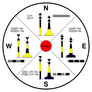
A cardinal mark indicates one of the four compass directions by:
- the direction of its two conical top-marks, which can both point up, indicating north; down, indicating south; towards each other, indicating west; or away from each other, indicating east
- its distinctive pattern of black and yellow stripes, which follows the orientation of the cones - the black stripe is in the position pointed to by the cones (eg at the top for a north cardinal, in the middle for a west cardinal)
- optionally, its distinctive sequence of flashing light, which consists of a sequence of quick or very quick flashes whose number gives the clockface position which corresponds to the direction of the cardinal (eg three for an east cardinal, nine for a west; north has continuous flashes, and south may be augmented with a long flash, to help distinguish it from a west in difficult conditions)
The topmark configurations for north and south are self-explanatory (both cones pointing up, or both pointing down). Those for east and west "follow the Sun"—the top cone points in the direction in which the rising
Sunrise
Sunrise is the instant at which the upper edge of the Sun appears above the horizon in the east. Sunrise should not be confused with dawn, which is the point at which the sky begins to lighten, some time before the sun itself appears, ending twilight...
(for an east mark) or setting
Sunset
Sunset or sundown is the daily disappearance of the Sun below the horizon in the west as a result of Earth's rotation.The time of sunset is defined in astronomy as the moment the trailing edge of the Sun's disk disappears below the horizon in the west...
(for a west mark) Sun appears to move with respect to the horizon, while the bottom cone points in the direction in which its reflection on the ocean surface appears to move. (An alternative memory aid is to see cones pointing inwards as a waist ("west"), and cones pointing out forming an egg ("east").
In the diagram, the light sequence is indicated by the white-banded pattern and the notation Q (for quick) or VQ (very quick). Either the quick or the very quick sequence may be used; the choice allows for two similar nearby marks to be uniquely identified by their lights.
A cardinal mark may be used to accomplish the following:
- Indicate that the deepest water is an area on the named side of the mark
- Indicate the safe side on which to pass a danger
- Draw attention to a feature in a channel, such as a bend, junction, branch, or end of a shoal
- Draw attention to a new danger such as a grounded ship. In such cases two equal marks are often placed together to indicate that it's a newly marked danger and is not yet printed in official maps.
See also
- NavigationNavigationNavigation is the process of monitoring and controlling the movement of a craft or vehicle from one place to another. It is also the term of art used for the specialized knowledge used by navigators to perform navigation tasks...
- Lateral markLateral markA lateral buoy, lateral post or lateral mark, as defined by the International Association of Lighthouse Authorities, is a sea mark used in maritime pilotage to indicate the edge of a channel....
- Safe water markSafe water markthumb|right|Examples of Safe Water MarksA Safe Water Mark, as defined by the International Association of Lighthouse Authorities, is a sea mark used in maritime pilotage to indicate the end of a channel...
- Isolated danger markIsolated danger markAn Isolated Danger Mark, as defined by the International Association of Lighthouse Authorities, is a sea mark used in maritime pilotage to indicate a hazard to shipping such as a partially submerged rock....
- Special markSpecial markA Special Mark, as defined by the International Association of Lighthouse Authorities, is a sea mark used in maritime pilotage to indicate the boundary of an obstruction, administrative area such as a speed limit, water skiing or mooring area, or to highlight other features such as outfall sewerage...