

Cape Lookout (Oregon)
Encyclopedia
Headlands and bays
Headlands and bays are two related features of the coastal environment.- Geology and geography :Headlands and bays are often found on the same coastline. A bay is surrounded by land on three sides, whereas a headland is surrounded by water on three sides. Headlands are characterized by high,...
along the Pacific Ocean
Pacific Ocean
The Pacific Ocean is the largest of the Earth's oceanic divisions. It extends from the Arctic in the north to the Southern Ocean in the south, bounded by Asia and Australia in the west, and the Americas in the east.At 165.2 million square kilometres in area, this largest division of the World...
coast of northwestern Oregon
Oregon
Oregon is a state in the Pacific Northwest region of the United States. It is located on the Pacific coast, with Washington to the north, California to the south, Nevada on the southeast and Idaho to the east. The Columbia and Snake rivers delineate much of Oregon's northern and eastern...
in the United States
United States
The United States of America is a federal constitutional republic comprising fifty states and a federal district...
. It is located in southwestern Tillamook County
Tillamook County, Oregon
Tillamook County is a county located in the U.S. state of Oregon. The county is named for the Tillamook, a Native American tribe who were living in the area in the early 19th century at the time of European American settlement. In 2010, the county's population was 25,250...
, approximately 10 mi (16 km) southwest of Tillamook
Tillamook, Oregon
The city of Tillamook is the county seat of Tillamook County, Oregon, United States. The city is located on the southeast end of Tillamook Bay on the Pacific Ocean. The population was 4,352 at the 2000 census...
, just south of Netarts Bay
Netarts Bay
Netarts Bay is a bay on the northern Oregon Coast of the U.S. state of Oregon, located about southwest of Tillamook.The bay is approximately 5 by 1.5 miles and totals in area, making it Oregon's seventh largest bay....
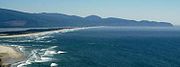
. The promontory extends 1 mi (1.6 km) perpendicular to the coast, and is approximately 0.25 mi (0.5 km) wide at its base, tapering as it extends outward from the coast. Cape Lookout State Park
Cape Lookout State Park
Cape Lookout State Park is a state park on Cape Lookout in the U.S. state of Oregon. It is located in Tillamook County, south of the city of Tillamook, on a sand spit between Netarts Bay and the Pacific Ocean....
is located on the north side of the promontory, which is part of the Siuslaw National Forest
Siuslaw National Forest
Siuslaw National Forest is a national forest in western Oregon, United States. Established in 1908, the Siuslaw is made up of a wide variety of ecosystems, ranging from coastal forests to sand dunes.- Geography :...
.
The Cape Lookout Trail is a popular hiking trail, extending 2.5 miles through Sitka spruce
Sitka Spruce
Picea sitchensis, the Sitka Spruce, is a large coniferous evergreen tree growing to 50–70 m tall, exceptionally to 95 m tall, and with a trunk diameter of up to 5 m, exceptionally to 6–7 m diameter...
forest to the tip of the promontory. The cliff-top viewpoint offers views of Cape Kiwanda and Cascade Head
Cascade Head
Cascade Head is a headland and UNESCO biosphere reserve and United States Forest Service Experimental Forest. It is situated southwest of Portland, Oregon on the Oregon Coast between Lincoln City and Neskowin...
to the south, and Cape Meares
Cape Meares
Cape Meares is a small headland on the Pacific coast in Tillamook County, Oregon, United States. The cape forms a high steep bluff on the south end of Tillamook Bay, approximately five miles northwest of the city of Tillamook...
and Neahkahnie Mountain
Neahkahnie Mountain
Neahkahnie Mountain is a mountain on the Oregon Coast, north of Manzanita in Oswald West State Park overlooking U.S. Route 101. The peak is part of the Northern Oregon Coast Range, which is part of the Oregon Coast Range...
to the north. Migrating whales can also be seen, generally from December through June.
During World War II
World War II
World War II, or the Second World War , was a global conflict lasting from 1939 to 1945, involving most of the world's nations—including all of the great powers—eventually forming two opposing military alliances: the Allies and the Axis...
, the cape was the location of a notable crash of a B-17 Flying Fortress bomber. There was one survivor (the bombardier), Wilbur L. Perez. A plaque on the cape memorializes the victims of the crash.