

Cape Fear
Encyclopedia
Headlands and bays
Headlands and bays are two related features of the coastal environment.- Geology and geography :Headlands and bays are often found on the same coastline. A bay is surrounded by land on three sides, whereas a headland is surrounded by water on three sides. Headlands are characterized by high,...
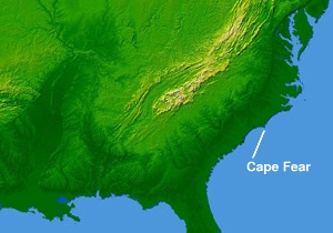
jutting into the Atlantic Ocean
Atlantic Ocean
The Atlantic Ocean is the second-largest of the world's oceanic divisions. With a total area of about , it covers approximately 20% of the Earth's surface and about 26% of its water surface area...
from Bald Head Island on the coast of North Carolina
North Carolina
North Carolina is a state located in the southeastern United States. The state borders South Carolina and Georgia to the south, Tennessee to the west and Virginia to the north. North Carolina contains 100 counties. Its capital is Raleigh, and its largest city is Charlotte...
in the southeastern United States
United States
The United States of America is a federal constitutional republic comprising fifty states and a federal district...
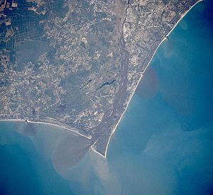
. It is largely formed of barrier beaches and the silty outwash of the Cape Fear River
Cape Fear River
The Cape Fear River is a long blackwater river in east central North Carolina in the United States. It flows into the Atlantic Ocean near Cape Fear, from which it takes its name. The overall water quality of the river is continuously measured and monitored by and conducted by the , , and the...
as it drains the southeast coast of North Carolina through an estuary
Estuary
An estuary is a partly enclosed coastal body of water with one or more rivers or streams flowing into it, and with a free connection to the open sea....
south of Wilmington
Wilmington, North Carolina
Wilmington is a port city in and is the county seat of New Hanover County, North Carolina, United States. The population is 106,476 according to the 2010 Census, making it the eighth most populous city in the state of North Carolina...
. Cape Fear is formed by the intersection of two sweeping arcs of shifting, low-lying beach, the result of longshore currents which also form the treacherous, shifting Frying Pan Shoals
Frying Pan Shoals
The Frying Pan Shoals are a long, shifting area of shoals off the coast of Cape Fear in North Carolina, United States. The shoals have been a hazard to ships in the area since the beginning of European exploration of the area; the area is littered with shipwrecks. The southern edge of the shoals...
, part of the Graveyard of the Atlantic
Graveyard of the Atlantic
Graveyard of the Atlantic is a nickname of two locations known for numerous shipwrecks: the treacherous waters in the Atlantic Ocean along the Outer Banks of North Carolina and the Virginia coastline south of the entrance to the Chesapeake Bay at Cape Henry; and around Sable Island, off the coast...
.
Dune
Dune
In physical geography, a dune is a hill of sand built by wind. Dunes occur in different forms and sizes, formed by interaction with the wind. Most kinds of dunes are longer on the windward side where the sand is pushed up the dune and have a shorter "slip face" in the lee of the wind...
s dominated by sea oats occur from the upper beach driftline back to the stable secondary dunes, where they mix with other grasses such as Saltmeadow Cordgrass and panic grass, as well as seaside goldenrod, spurge
Spurge
Euphorbia is a genus of plants belonging to the family Euphorbiaceae. Consisting of 2008 species, Euphorbia is one of the most diverse genera in the plant kingdom, exceeded possibly only by Senecio. Members of the family and genus are sometimes referred to as Spurges...
and other herbs to form a stable salt-tolerant grassland
Grassland
Grasslands are areas where the vegetation is dominated by grasses and other herbaceous plants . However, sedge and rush families can also be found. Grasslands occur naturally on all continents except Antarctica...
.
The Cape Fear estuary drains the largest watershed in North Carolina, containing 27% of the state's population.
Giovanni da Verrazzano, the Italian explorer sailing for France
France
The French Republic , The French Republic , The French Republic , (commonly known as France , is a unitary semi-presidential republic in Western Europe with several overseas territories and islands located on other continents and in the Indian, Pacific, and Atlantic oceans. Metropolitan France...
, made landfall after crossing the Atlantic at or near Cape Fear on March 1, 1524.
The name comes from the 1585 expedition of Sir Richard Grenville
Richard Grenville
Sir Richard Grenville was an English sailor, sea captain and explorer. He took part in the early English attempts to settle the New World, and also participated in the fight against the Spanish Armada...
. Sailing to Roanoke Island
Roanoke Island
Roanoke Island is an island in Dare County near the coast of North Carolina, United States. It was named after the historical Roanoke Carolina Algonquian people who inhabited the area in the 16th century at the time of English exploration....
, his ship became embayed behind the cape. Some of the crew were afraid they would wreck, giving rise to the name Cape Fear. It is the fifth-oldest surviving English place name in the U.S.
Cape Fear was the landing place of General Sir Henry Clinton during the American Revolutionary War
American Revolutionary War
The American Revolutionary War , the American War of Independence, or simply the Revolutionary War, began as a war between the Kingdom of Great Britain and thirteen British colonies in North America, and ended in a global war between several European great powers.The war was the result of the...
on May 3, 1775. The 1962 movie Cape Fear
Cape Fear (1962 film)
Cape Fear is a 1962 film starring Gregory Peck, Robert Mitchum and Polly Bergen. It was adapted by James R. Webb from the novel The Executioners by John D. MacDonald. It was directed by J. Lee Thompson, and released on April 12, 1962...
and its 1991 remake
Cape Fear (1991 film)
Cape Fear is a 1991 thriller film directed by Martin Scorsese and a remake of the 1962 film of the same name. It stars Robert De Niro, Nick Nolte, Jessica Lange and Juliette Lewis and features cameos from Gregory Peck, Robert Mitchum and Martin Balsam, who all appeared in the 1962 original film...
were set at Cape Fear.