

Canadian High Arctic Ionospheric Network
Encyclopedia
University of New Brunswick
The University of New Brunswick is a Canadian university located in the province of New Brunswick. UNB is the oldest English language university in Canada and among the first public universities in North America. The university has two main campuses: the original campus founded in 1785 in...
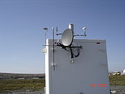
. The CHAIN instruments include high data-rate GPS receivers and digital ionosondes. After passing through the Earth's ionosphere
Ionosphere
The ionosphere is a part of the upper atmosphere, comprising portions of the mesosphere, thermosphere and exosphere, distinguished because it is ionized by solar radiation. It plays an important part in atmospheric electricity and forms the inner edge of the magnetosphere...
, microwave
Microwave
Microwaves, a subset of radio waves, have wavelengths ranging from as long as one meter to as short as one millimeter, or equivalently, with frequencies between 300 MHz and 300 GHz. This broad definition includes both UHF and EHF , and various sources use different boundaries...
GPS signals carry information about the total electron content
Total electron content
Total electron content is an important descriptive quantity for the ionosphere of the Earth. TEC is the total number of electrons present along a path between two points, with units of electrons per square meter, where 1016 electrons/m² = 1 TEC unit .TEC is significant in determining the...
(TEC). This information is commonly used to improve the precision of GPS and to study ionospheric morphology. Ionosondes transmit pulses of radio signals in the Medium Frequency
Medium frequency
Medium frequency refers to radio frequencies in the range of 300 kHz to 3 MHz. Part of this band is the medium wave AM broadcast band. The MF band is also known as the hectometer band or hectometer wave as the wavelengths range from ten down to one hectometers...
(MF) and High Frequency
High frequency
High frequency radio frequencies are between 3 and 30 MHz. Also known as the decameter band or decameter wave as the wavelengths range from one to ten decameters . Frequencies immediately below HF are denoted Medium-frequency , and the next higher frequencies are known as Very high frequency...
(HF) ranges, whose echos are analyzed to measure height and density of the ionosphere. Advanced digital ionosondes used in the CHAIN network are also able to measure the bulk motion of ionospheric plasma.
Most of the CHAIN instruments are located within the polar cap defined as a region of open magnetic field
Magnetic field
A magnetic field is a mathematical description of the magnetic influence of electric currents and magnetic materials. The magnetic field at any given point is specified by both a direction and a magnitude ; as such it is a vector field.Technically, a magnetic field is a pseudo vector;...
lines. The polar cap ionosphere
Ionosphere
The ionosphere is a part of the upper atmosphere, comprising portions of the mesosphere, thermosphere and exosphere, distinguished because it is ionized by solar radiation. It plays an important part in atmospheric electricity and forms the inner edge of the magnetosphere...
is directly linked to the interplanetary magnetic field
Interplanetary Magnetic Field
The interplanetary magnetic field is the term for the solar magnetic field carried by the solar wind among the planets of the Solar System....
carried by the solar wind
Solar wind
The solar wind is a stream of charged particles ejected from the upper atmosphere of the Sun. It mostly consists of electrons and protons with energies usually between 1.5 and 10 keV. The stream of particles varies in temperature and speed over time...
. Polar cap thus provides a vantage point for the study of energy exchange between the solar wind
Solar wind
The solar wind is a stream of charged particles ejected from the upper atmosphere of the Sun. It mostly consists of electrons and protons with energies usually between 1.5 and 10 keV. The stream of particles varies in temperature and speed over time...
, magnetosphere
Magnetosphere
A magnetosphere is formed when a stream of charged particles, such as the solar wind, interacts with and is deflected by the intrinsic magnetic field of a planet or similar body. Earth is surrounded by a magnetosphere, as are the other planets with intrinsic magnetic fields: Mercury, Jupiter,...
and ionosphere
Ionosphere
The ionosphere is a part of the upper atmosphere, comprising portions of the mesosphere, thermosphere and exosphere, distinguished because it is ionized by solar radiation. It plays an important part in atmospheric electricity and forms the inner edge of the magnetosphere...
.
CHAIN is an integral part of the Canadian Geospace Monitoring
Canadian Geospace Monitoring
Canadian Geospace Monitoring is a Canadian space science program that was initiated in 2005. CGSM is funded primarily by the Canadian Space Agency, and consists of networks of imagers, meridian scanning photometers, riometers, magnetometers, digital ionosondes, and High Frequency SuperDARN radars...
(CGSM) programme. It provides ground support for Canadian and international scientific space missions such as THEMIS
Themis
Themis is an ancient Greek Titaness. She is described as "of good counsel", and is the embodiment of divine order, law, and custom. Themis means "divine law" rather than human ordinance, literally "that which is put in place", from the verb τίθημι, títhēmi, "to put"...
and CASSIOPE
CASSIOPE
CASSIOPE is a hybrid satellite project of the Canadian Space Agency. Planned for launch in an elliptical polar orbit in 2011, it will carry a commercial communications system called Cascade and a scientific experiment package called ePOP...
.
CHAIN instrument sites
| Location | Station code | Coordinates | Instruments |
|---|---|---|---|
| Cambridge Bay, Nunavut Cambridge Bay, Nunavut Cambridge Bay, named for Prince Adolphus, Duke of Cambridge, is a hamlet located in the Kitikmeot Region of Nunavut, Canada... |
cbbc | 69.12°N 105.03°W | GPS, ionosonde |
| Eureka, Nunavut Eureka, Nunavut Eureka is a small research base on Fosheim Peninsula, Ellesmere Island, Qikiqtaaluk Region, in the Canadian territory of Nunavut. It is located on the north side of Slidre Fiord, which enters Eureka Sound farther west. It is the second-northernmost permanent research community in the world. The... |
eurc | 79.99°N 85.90°W | GPS, ionosonde |
| Hall Beach, Nunavut Hall Beach, Nunavut Hall Beach is an Inuit settlement, Qikiqtaaluk Region in Nunavut, Canada, established in 1957 during the construction of a Distant Early Warning site... |
halc | 68.77°N 81.26°W | GPS, ionosonde |
| Iqaluit, Nunavut Iqaluit, Nunavut Iqaluit is the territorial capital and the largest community of the Canadian territory of Nunavut. Iqaluit is located on the south coast of Baffin Island at the head of Frobisher Bay. As of the 2006 census the population was 6,184, an increase of 18.1 percent from the 2001 census; it has the... |
iqac | 63.73°N 68.54°W | GPS, ionosonde |
| Ministik Lake, Alberta Alberta Alberta is a province of Canada. It had an estimated population of 3.7 million in 2010 making it the most populous of Canada's three prairie provinces... |
edmc | 53.35°N 112.97°W | GPS |
| Pond Inlet, Nunavut Pond Inlet, Nunavut Pond Inlet is a small, predominantly Inuit community in the Qikiqtaaluk Region of Nunavut, Canada and is located at the top of Baffin Island. As of the 2006 census the population was 1,315, an increase of 7.8% from the 2001 census making it the largest of the four hamlets above the 72nd parallel... |
ponc | 72.69°N 77.95°W | GPS, ionosonde |
| Qikiqtarjuaq, Nunavut Qikiqtarjuaq, Nunavut -External links:* *... |
qikc | 67.56°N 64.03°W | GPS |
| Resolute, Nunavut Resolute, Nunavut Resolute or Resolute Bay is a small Inuit hamlet on Cornwallis Island in Nunavut, Canada. It is situated at the northern end of Resolute Bay and the Northwest Passage and is part of the Qikiqtaaluk Region.... |
resc | 74.75°N 95.00°W | GPS, ionosonde |
| Sanikiluaq, Nunavut Sanikiluaq, Nunavut Sanikiluaq is a small Inuit hamlet located on the north coast of Flaherty Island in Hudson Bay, on the Belcher Islands, in the Qikiqtaaluk Region of Nunavut, Canada. Nuiyak School, with 23 staff, teaches Grades K-12, with 302 students enrolled. The principal is Tim Hoyt... |
sanc | 56.54°N 79.23°W | GPS |
| Taloyoak, Nunavut Taloyoak, Nunavut Taloyoak or Talurjuaq is located on the Boothia Peninsula, Kitikmeot, in Canada's Nunavut Territory. The community is served only by air and by annual supply sealift. Taloyoak may mean "large blind", referring to a stone caribou blind or a screen used for caribou hunting... |
talc | 69.54°N 93.56°W | GPS |