
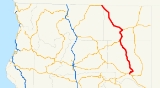
California State Route 139
Encyclopedia
State Route 139 is a state highway
in the U.S. state
of California
. Running from Susanville
north to Oregon Route 39, it forms part of the shortest route between Reno, Nevada
and Klamath Falls, Oregon
. The entire route is part of the California Freeway and Expressway System
, but is a two-lane road. North of the SR 299
overlap, SR 139 is an eligible State Scenic Highway, but has not been designated as such; the short piece north of Tulelake
is however part of the federal Volcanic Legacy Scenic Byway
. The portion north of SR 299 is also in the Interregional Road System as a High Emphasis Route and in the National Highway System
. North of SR 299, the highway was built by the federal government
and turned over to the state in about 1940; the remainder was built by a joint highway district of Lassen
and Modoc
Counties, completed in 1956, and given to the state in 1959.
 State Route 139 begins at SR 36
in Susanville
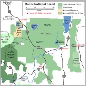
, and heads northeast up Antelope Mountain before turning north and descending into the Eagle Lake Basin. The highway continues north and northwest through valleys and over hills and through a part of the Modoc National Forest
, and then enters the east end of the Big Valley, where it begins to overlap SR 299
through Adin
. The combined routes continue northerly through another part of the forest and over Adin Pass into the Warm Springs Valley, where SR 139 splits to the northwest near Canby
. SR 139 runs northwest and north over mostly flat terrain through the center of the national forest before turning northwest and cutting across the intermittent Tule Lake
, through the city of Tulelake
, to the Oregon
state line at Hatfield. At an intersection right on the state line, SR 161 begins to the west, and Oregon Route 39 continues northwest towards Klamath Falls.
to the Oregon
state line towards Klamath Falls, via Bieber
. This would be part of a road connecting Reno, Nevada
and Klamath Falls east of the Sierra Nevada, which would attract heavy traffic and improve access to Crater Lake
and Lassen Volcanic
National Park
s. A local county road already followed this path, but it was unpaved, mostly dirt
and gravel
but with sections of rock and bad sand. This was close to the present SR 139, with notable deviations via Hayden Hill
, via Bieber and Lookout
, and via Malin, Oregon
(as Tule Lake
covered SR 139's current location).
By the mid-1920s, the main road southeast from Klamath Falls, still unimproved in California, headed southeast to State Highway Route 28 (now SR 299
) at Canby
rather than south to Bieber. There travelers could head east on Route 28 to Alturas
and south on the present US 395
(not a state highway north of Susanville until 1933) towards Reno. The California state legislature passed a law in 1939, providing for state takeover of the Canby-Oregon road if the U.S. Forest Service and Bureau of Public Roads were to construct and pave it. The road was in fact mostly paved by mid-1939, and under construction or completed by mid-1940, when Oregon Route 58 opened, continuing the corridor northwest from Klamath Falls. In 1943 the legislature gave it the Route 210 designation; Oregon had added the short connecting Hatfield Highway to its state highway system in 1937.
Lassen
and Modoc
Counties organized Joint Highway District No. 14 on December 21, 1929 to construct and maintain a road from Susanville via Adin
to Oregon. However, since the state took over the part north of Adin, the district's scope was narrowed to Susanville-Adin. It finally completed work in 1956, and held a ceremony on August 26, in which it placed a monument at a point near Eagle Lake
. The legislature added the road to the state highway system as Route 216 in 1959. (The portion south of Horse Lake Road became an extension of Route 20 instead; this route from Susanville to Ravendale
(later Termo
) was never constructed by the state, and was deleted from SR 36
in 1998.) Also in 1959, a spur of Route 210 west to Dorris
was added; this became SR 161 in 1964.
By 1946, the Canby-Oregon portion had been marked as Sign Route 139, connecting with Oregon Route 39; it was extended south over US 299 to Adin and Routes 216 and 20 to Susanville by 1960. The number was legislatively adopted, replacing Routes 210 and 216, in the 1964 renumbering. It has remained a two-lane road, despite being added to the California Freeway and Expressway System
in 1959 (Canby to Oregon) and 1965 (Susanville to Adin).
{| class=wikitable
!County
!Location
!Postmile
!Destinations
!Notes
|-
|rowspan=4|Lassen
LAS 0.00-66.64
|Susanville
|0.00
| – Reno
, Red Bluff
|
|-
|
|
|
|
|-
|
|43.27
|Termo-Grasshopper Road – Termo
|
|-
|
|61.46
|
|
|-
|rowspan=4|Modoc
MOD 0.00-50.68
|Adin
|bgcolor=#ddffdd|0.23
0.33Indicates that the postmile represents the distance along SR 299
rather than SR 139.
|bgcolor=#ddffdd|
|bgcolor=#ddffdd|South end of SR 299 overlap
|-
|Canby
|bgcolor=#ddffdd|21.75
0.23
|bgcolor=#ddffdd|
|bgcolor=#ddffdd|North end of SR 299 overlap
|-
|
|17.35
|Lookout-Hackamore Road – Lookout
, Bieber
|
|-
|
|40.45
|County Road 114
|
|-
|rowspan=4|Siskiyou
SIS 0.00-5.04
|Tulelake
|1.04
|East West Road, E Street (Volcanic Legacy Scenic Byway
), Osborne Road
|
|-
|
|5.04
|, Malin
|
|-
|
|5.04
|colspan=2 align=center|Oregon state line
|-
|
|5.04
|
|Continuation beyond SR 161 and the Oregon state line
State highway
State highway, state road or state route can refer to one of three related concepts, two of them related to a state or provincial government in a country that is divided into states or provinces :#A...
in the U.S. state
U.S. state
A U.S. state is any one of the 50 federated states of the United States of America that share sovereignty with the federal government. Because of this shared sovereignty, an American is a citizen both of the federal entity and of his or her state of domicile. Four states use the official title of...
of California
California
California is a state located on the West Coast of the United States. It is by far the most populous U.S. state, and the third-largest by land area...
. Running from Susanville
Susanville, California
Susanville is the county seat of Lassen County, California, United States. Susanville is located on the Susan River in the south-central part of the county, at an elevation of 4186 feet . The population was 17,974 at the 2010 census, up from 13,541 at the 2000 census...
north to Oregon Route 39, it forms part of the shortest route between Reno, Nevada
Reno, Nevada
Reno is the county seat of Washoe County, Nevada, United States. The city has a population of about 220,500 and is the most populous Nevada city outside of the Las Vegas metropolitan area...
and Klamath Falls, Oregon
Klamath Falls, Oregon
Klamath Falls is a city in Klamath County, Oregon, United States. Originally called Linkville when George Nurse founded the town in 1867, after the Link River on whose falls this city sat, although no falls currently exist; the name was changed to Klamath Falls in 1892...
. The entire route is part of the California Freeway and Expressway System
California Freeway and Expressway System
The California Freeway and Expressway System is a system of existing or planned freeways and expressways in the U.S. state of California. It is defined by the Streets and Highways Code.-List of roads in the system:*State Route 1 *State Route 2...
, but is a two-lane road. North of the SR 299
California State Route 299
State Route 299 is a state highway in the U.S. state of California that runs across the northern part of the state. It runs from Arcata on the Pacific Ocean to the border with Nevada. Between Arcata and Redding, Route 299 junctions with State Route 96 and is briefly co-signed with State Route 3. In...
overlap, SR 139 is an eligible State Scenic Highway, but has not been designated as such; the short piece north of Tulelake
Tulelake, California
Tulelake is a city in Siskiyou County, California, United States. It is named after the nearby Tule Lake. The population was 1,010 at the 2010 census, down from 1,020 at the 2000 census.-Geography:Tulelake is located at ....
is however part of the federal Volcanic Legacy Scenic Byway
Volcanic Legacy Scenic Byway
The Volcanic Legacy Scenic Byway is an All-American Road in the U.S. states of California and Oregon. It is roughly 500 miles long and travels through the Cascade Range past numerous volcanoes. It is composed of two separate National Scenic Byways, the Volcanic Legacy Scenic Byway - Oregon and...
. The portion north of SR 299 is also in the Interregional Road System as a High Emphasis Route and in the National Highway System
National Highway System (United States)
The National Highway System is a network of strategic highways within the United States, including the Interstate Highway System and other roads serving major airports, ports, rail or truck terminals, railway stations, pipeline terminals and other strategic transport facilities.Individual states...
. North of SR 299, the highway was built by the federal government
Federal government of the United States
The federal government of the United States is the national government of the constitutional republic of fifty states that is the United States of America. The federal government comprises three distinct branches of government: a legislative, an executive and a judiciary. These branches and...
and turned over to the state in about 1940; the remainder was built by a joint highway district of Lassen
Lassen County, California
Lassen County is a county located in the northeastern portion of the U.S. state of California. As of the 2010 census, the population was 34,895, up from 33,828 at the 2000 census...
and Modoc
Modoc County, California
Modoc County is a county located in the far northeast corner of the U.S. state of California, bounded by the state of Oregon to the north and the state of Nevada to the east. As of the 2010 census, its population was 9,686, up from 9,449 at the 2000 census. The current county seat is Alturas, the...
Counties, completed in 1956, and given to the state in 1959.
Route description
California State Route 36
State Route 36 is an east–west state highway in the U.S. state of California that is routed from U.S. Route 101 in Humboldt County to U.S. Route 395 just east of Susanville in Lassen County. The portion of SR 36 travelling past Lassen Volcanic National Park and Lake Almanor is part of the...
in Susanville
Susanville, California
Susanville is the county seat of Lassen County, California, United States. Susanville is located on the Susan River in the south-central part of the county, at an elevation of 4186 feet . The population was 17,974 at the 2010 census, up from 13,541 at the 2000 census...
, and heads northeast up Antelope Mountain before turning north and descending into the Eagle Lake Basin. The highway continues north and northwest through valleys and over hills and through a part of the Modoc National Forest
Modoc National Forest
Modoc National Forest is a national forest in northeastern California, covering parts of Modoc , Lassen , and Siskiyou counties. Most of the forest was covered by an immense lava flow millions of years ago. The eastern part of the forest east of Alturas contains a spur of the Cascade Range to...
, and then enters the east end of the Big Valley, where it begins to overlap SR 299
California State Route 299
State Route 299 is a state highway in the U.S. state of California that runs across the northern part of the state. It runs from Arcata on the Pacific Ocean to the border with Nevada. Between Arcata and Redding, Route 299 junctions with State Route 96 and is briefly co-signed with State Route 3. In...
through Adin
Adin, California
Adin is a census-designated place in Modoc County, California. It is located southwest of Alturas, at an elevation of 4203 feet...
. The combined routes continue northerly through another part of the forest and over Adin Pass into the Warm Springs Valley, where SR 139 splits to the northwest near Canby
Canby, California
Canby is a census-designated place in Modoc County, California. It is located west of Alturas, at an elevation of 4314 feet . It had a population of 315 at the 2010 census. The ZIP Code is 96015...
. SR 139 runs northwest and north over mostly flat terrain through the center of the national forest before turning northwest and cutting across the intermittent Tule Lake
Tule Lake
Tule Lake is an intermittent lake covering an area of , long and across, in northeastern Siskiyou County and northwestern Modoc County in California, along the border with Oregon.-Geography:Tule Lake is fed by the Lost River...
, through the city of Tulelake
Tulelake, California
Tulelake is a city in Siskiyou County, California, United States. It is named after the nearby Tule Lake. The population was 1,010 at the 2010 census, down from 1,020 at the 2000 census.-Geography:Tulelake is located at ....
, to the Oregon
Oregon
Oregon is a state in the Pacific Northwest region of the United States. It is located on the Pacific coast, with Washington to the north, California to the south, Nevada on the southeast and Idaho to the east. The Columbia and Snake rivers delineate much of Oregon's northern and eastern...
state line at Hatfield. At an intersection right on the state line, SR 161 begins to the west, and Oregon Route 39 continues northwest towards Klamath Falls.
History
In 1925, a state-created "California Highway Advisory Committee" recommended a number of additions to the state highway system; among these was a route from SusanvilleSusanville, California
Susanville is the county seat of Lassen County, California, United States. Susanville is located on the Susan River in the south-central part of the county, at an elevation of 4186 feet . The population was 17,974 at the 2010 census, up from 13,541 at the 2000 census...
to the Oregon
Oregon
Oregon is a state in the Pacific Northwest region of the United States. It is located on the Pacific coast, with Washington to the north, California to the south, Nevada on the southeast and Idaho to the east. The Columbia and Snake rivers delineate much of Oregon's northern and eastern...
state line towards Klamath Falls, via Bieber
Bieber, California
Bieber is a census-designated place in Lassen County, California. It is located on the Pit River north-northwest of Susanville, at an elevation of 4124 feet . Its population was 312 at the 2010 census. The ZIP Code is 96009. The community is inside area code 530.-History:The settlement sprang up...
. This would be part of a road connecting Reno, Nevada
Reno, Nevada
Reno is the county seat of Washoe County, Nevada, United States. The city has a population of about 220,500 and is the most populous Nevada city outside of the Las Vegas metropolitan area...
and Klamath Falls east of the Sierra Nevada, which would attract heavy traffic and improve access to Crater Lake
Crater Lake National Park
Crater Lake National Park is a United States National Park located in southern Oregon. Established in 1902, Crater Lake National Park is the sixth oldest national park in the United States and the only one in the state of Oregon...
and Lassen Volcanic
Lassen Volcanic National Park
Lassen Volcanic National Park is a United States National Park in northeastern California. The dominant feature of the park is Lassen Peak; the largest plug dome volcano in the world and the southern-most volcano in the Cascade Range...
National Park
National Park Service
The National Park Service is the U.S. federal agency that manages all national parks, many national monuments, and other conservation and historical properties with various title designations...
s. A local county road already followed this path, but it was unpaved, mostly dirt
Dirt road
Dirt road is a common term for an unpaved road made from the native material of the land surface through which it passes, known to highway engineers as subgrade material. Dirt roads are suitable for vehicles; a narrower path for pedestrians, animals, and possibly small vehicles would be called a...
and gravel
Gravel road
A gravel road is a type of unpaved road surfaced with gravel that has been brought to the site from a quarry or stream bed. They are common in less-developed nations, and also in the rural areas of developed nations such as Canada and the United States. In New Zealand, they are known as 'metal roads'...
but with sections of rock and bad sand. This was close to the present SR 139, with notable deviations via Hayden Hill
Hayden Hill, California
Hayden Hill is an unincorporated community in Lassen County, California. It is located north of Lava Peak, at an elevation of 5715 feet ....
, via Bieber and Lookout
Lookout, California
Lookout is a census-designated place in Modoc County, California. It is located west of Adin,at an elevation of 4144 feet . Lookout's ZIP Code is 96054....
, and via Malin, Oregon
Malin, Oregon
Malin is a city in Klamath County, Oregon, United States. The population was 637 at the 2000 census.-History:According to Lewis A. McArthur, Malin was settled 30 September 1909 on land that was formerly at the bottom of Tule Lake by 65 Bohemian families who named the new town for their former home....
(as Tule Lake
Tule Lake
Tule Lake is an intermittent lake covering an area of , long and across, in northeastern Siskiyou County and northwestern Modoc County in California, along the border with Oregon.-Geography:Tule Lake is fed by the Lost River...
covered SR 139's current location).
By the mid-1920s, the main road southeast from Klamath Falls, still unimproved in California, headed southeast to State Highway Route 28 (now SR 299
California State Route 299
State Route 299 is a state highway in the U.S. state of California that runs across the northern part of the state. It runs from Arcata on the Pacific Ocean to the border with Nevada. Between Arcata and Redding, Route 299 junctions with State Route 96 and is briefly co-signed with State Route 3. In...
) at Canby
Canby, California
Canby is a census-designated place in Modoc County, California. It is located west of Alturas, at an elevation of 4314 feet . It had a population of 315 at the 2010 census. The ZIP Code is 96015...
rather than south to Bieber. There travelers could head east on Route 28 to Alturas
Alturas, California
Alturas is the county seat of Modoc County, California, United States. Alturas is located on the Pit River, east of the center of Modoc County, at an elevation of 4370 feet...
and south on the present US 395
U.S. Route 395 in California
In the U.S. state of California, U.S. Route 395 is a route which traverses from Interstate 15 near the southern city limits of Hesperia, north to the Oregon state line in Modoc County near Goose Lake...
(not a state highway north of Susanville until 1933) towards Reno. The California state legislature passed a law in 1939, providing for state takeover of the Canby-Oregon road if the U.S. Forest Service and Bureau of Public Roads were to construct and pave it. The road was in fact mostly paved by mid-1939, and under construction or completed by mid-1940, when Oregon Route 58 opened, continuing the corridor northwest from Klamath Falls. In 1943 the legislature gave it the Route 210 designation; Oregon had added the short connecting Hatfield Highway to its state highway system in 1937.
Lassen
Lassen County, California
Lassen County is a county located in the northeastern portion of the U.S. state of California. As of the 2010 census, the population was 34,895, up from 33,828 at the 2000 census...
and Modoc
Modoc County, California
Modoc County is a county located in the far northeast corner of the U.S. state of California, bounded by the state of Oregon to the north and the state of Nevada to the east. As of the 2010 census, its population was 9,686, up from 9,449 at the 2000 census. The current county seat is Alturas, the...
Counties organized Joint Highway District No. 14 on December 21, 1929 to construct and maintain a road from Susanville via Adin
Adin, California
Adin is a census-designated place in Modoc County, California. It is located southwest of Alturas, at an elevation of 4203 feet...
to Oregon. However, since the state took over the part north of Adin, the district's scope was narrowed to Susanville-Adin. It finally completed work in 1956, and held a ceremony on August 26, in which it placed a monument at a point near Eagle Lake
Eagle Lake (Lassen County)
Eagle Lake is a lake in Lassen County approximately 15 miles north of Susanville, California. It is the second largest natural lake entirely in the state of California, United States....
. The legislature added the road to the state highway system as Route 216 in 1959. (The portion south of Horse Lake Road became an extension of Route 20 instead; this route from Susanville to Ravendale
Ravendale, California
Ravendale is an unincorporated community in Lassen County, California. It is located southeast of Termo, at an elevation of 5305 feet...
(later Termo
Termo, California
Termo is an unincorporated community in Lassen County, California. It is located on the Southern Pacific Railroad north-northeast of Susanville, at an elevation of 5305 feet . This town straddles U.S. Highway 395 north of Ravendale.In 1909, Termo was the terminus of the Nevada–California–Oregon...
) was never constructed by the state, and was deleted from SR 36
California State Route 36
State Route 36 is an east–west state highway in the U.S. state of California that is routed from U.S. Route 101 in Humboldt County to U.S. Route 395 just east of Susanville in Lassen County. The portion of SR 36 travelling past Lassen Volcanic National Park and Lake Almanor is part of the...
in 1998.) Also in 1959, a spur of Route 210 west to Dorris
Dorris, California
Dorris is a city in Siskiyou County, California, United States. The population was 939 at the 2010 census, up from 886 at the 2000 census.-Geography:...
was added; this became SR 161 in 1964.
By 1946, the Canby-Oregon portion had been marked as Sign Route 139, connecting with Oregon Route 39; it was extended south over US 299 to Adin and Routes 216 and 20 to Susanville by 1960. The number was legislatively adopted, replacing Routes 210 and 216, in the 1964 renumbering. It has remained a two-lane road, despite being added to the California Freeway and Expressway System
California Freeway and Expressway System
The California Freeway and Expressway System is a system of existing or planned freeways and expressways in the U.S. state of California. It is defined by the Streets and Highways Code.-List of roads in the system:*State Route 1 *State Route 2...
in 1959 (Canby to Oregon) and 1965 (Susanville to Adin).
Major intersections
- Note: Except where prefixed with a letter, postmiles were measured in 1964, based on the alignment as it existed at that time, and do not necessarily reflect current mileage. The numbers reset at county lines; the start and end postmiles in each county are given in the county column.
{| class=wikitable
!County
!Location
!Postmile
!Destinations
!Notes
|-
|rowspan=4|Lassen
Lassen County, California
Lassen County is a county located in the northeastern portion of the U.S. state of California. As of the 2010 census, the population was 34,895, up from 33,828 at the 2000 census...
LAS 0.00-66.64
|Susanville
Susanville, California
Susanville is the county seat of Lassen County, California, United States. Susanville is located on the Susan River in the south-central part of the county, at an elevation of 4186 feet . The population was 17,974 at the 2010 census, up from 13,541 at the 2000 census...
|0.00
| – Reno
Reno, Nevada
Reno is the county seat of Washoe County, Nevada, United States. The city has a population of about 220,500 and is the most populous Nevada city outside of the Las Vegas metropolitan area...
, Red Bluff
Red Bluff, California
Red Bluff is a city in and the county seat of Tehama County, California, United States. The population was 14,076 at the 2010 census, up from 13,147 at the 2000 census....
|
|-
|
|
|
|
|-
|
|43.27
|Termo-Grasshopper Road – Termo
Termo, California
Termo is an unincorporated community in Lassen County, California. It is located on the Southern Pacific Railroad north-northeast of Susanville, at an elevation of 5305 feet . This town straddles U.S. Highway 395 north of Ravendale.In 1909, Termo was the terminus of the Nevada–California–Oregon...
|
|-
|
|61.46
|
|
|-
|rowspan=4|Modoc
Modoc County, California
Modoc County is a county located in the far northeast corner of the U.S. state of California, bounded by the state of Oregon to the north and the state of Nevada to the east. As of the 2010 census, its population was 9,686, up from 9,449 at the 2000 census. The current county seat is Alturas, the...
MOD 0.00-50.68
|Adin
Adin, California
Adin is a census-designated place in Modoc County, California. It is located southwest of Alturas, at an elevation of 4203 feet...
|bgcolor=#ddffdd|0.23
0.33Indicates that the postmile represents the distance along SR 299
California State Route 299
State Route 299 is a state highway in the U.S. state of California that runs across the northern part of the state. It runs from Arcata on the Pacific Ocean to the border with Nevada. Between Arcata and Redding, Route 299 junctions with State Route 96 and is briefly co-signed with State Route 3. In...
rather than SR 139.
|bgcolor=#ddffdd|
|bgcolor=#ddffdd|South end of SR 299 overlap
|-
|Canby
Canby, California
Canby is a census-designated place in Modoc County, California. It is located west of Alturas, at an elevation of 4314 feet . It had a population of 315 at the 2010 census. The ZIP Code is 96015...
|bgcolor=#ddffdd|21.75
0.23
|bgcolor=#ddffdd|
|bgcolor=#ddffdd|North end of SR 299 overlap
|-
|
|17.35
|Lookout-Hackamore Road – Lookout
Lookout, California
Lookout is a census-designated place in Modoc County, California. It is located west of Adin,at an elevation of 4144 feet . Lookout's ZIP Code is 96054....
, Bieber
Bieber, California
Bieber is a census-designated place in Lassen County, California. It is located on the Pit River north-northwest of Susanville, at an elevation of 4124 feet . Its population was 312 at the 2010 census. The ZIP Code is 96009. The community is inside area code 530.-History:The settlement sprang up...
|
|-
|
|40.45
|County Road 114
|
|-
|rowspan=4|Siskiyou
Siskiyou County, California
Siskiyou County is a county located in the far northernmost part of the U.S. state of California, in the Shasta Cascade region on the Oregon border. Yreka is the county seat. Because of its substantial natural beauty, outdoor recreation opportunities, and Gold Rush era history, it is an important...
SIS 0.00-5.04
|Tulelake
Tulelake, California
Tulelake is a city in Siskiyou County, California, United States. It is named after the nearby Tule Lake. The population was 1,010 at the 2010 census, down from 1,020 at the 2000 census.-Geography:Tulelake is located at ....
|1.04
|East West Road, E Street (Volcanic Legacy Scenic Byway
Volcanic Legacy Scenic Byway
The Volcanic Legacy Scenic Byway is an All-American Road in the U.S. states of California and Oregon. It is roughly 500 miles long and travels through the Cascade Range past numerous volcanoes. It is composed of two separate National Scenic Byways, the Volcanic Legacy Scenic Byway - Oregon and...
), Osborne Road
|
|-
|
|5.04
|, Malin
Malin, Oregon
Malin is a city in Klamath County, Oregon, United States. The population was 637 at the 2000 census.-History:According to Lewis A. McArthur, Malin was settled 30 September 1909 on land that was formerly at the bottom of Tule Lake by 65 Bohemian families who named the new town for their former home....
|
|-
|
|5.04
|colspan=2 align=center|Oregon state line
|-
|
|5.04
|
|Continuation beyond SR 161 and the Oregon state line