
Calais, Vermont
Encyclopedia
Calais (ˈkælɪs) is a town in Washington County
, Vermont
, United States
. The population was 1,529 at the 2000 census. Calais is pronounced similarly to palace, not chalet. Calais contains the unincorporated communities of Adamant
, East Calais, North Calais, Kent's Corner, Maple Corner
and Pekin.
 Colonel Jacob Davis named Calais after the French port city of the same name
, during a time of general enthusiasm for things French as a result of France's aid during the American Revolution
.
The Wheelocks and Parkers were the first families to settle the town, in the latter part of the 18th century. In the early and mid 19th century, the Vermont wool
industry spawned sheep pastures in the town. Photographs of the time show a heavily de-forested Calais. Like many small Vermont towns, Calais was devastated by the Civil War. Volunteers from Calais flocked to the Union cause, most serving in the Army's volunteer regiments. In the post-Civil War era, agriculture turned from sheep to dairy and new families came to fill farms that were sold by the families and widows of Civil War Veterans.
Until the 1960s and 1970s, the town was a Republican stronghold, as was much of Vermont, but has voted Democratic in the past several decades.
. This name was allegedly given because the village had no church, though it did have a few active quarries
. In 1905, the residents petitioned the state legislature to change the name to Adamant
, chosen to suggest the hardness of granite.
Pekin is named after Peking (now Beijing
), China
, the result of a local farmer who had a friend who was a missionary to China. The missionary sent some Chinese wheat back to Vermont, the farmer planted it, and it flourished. It became the style to give directions using the wheat field as a landmark ("up by the Pekin wheat", or "just past the Pekin wheat"). Eventually, the location of the field came to be known simply as Pekin. Another version suggests that the missionary sent back rice, and that the farmer planted the rice in a low-lying plain, which flooded each spring. The river came to be known as Peking Brook, later and presently Pekin Brook.
, the town has a total area of 38.6 square miles (99.9 km2), of which 38.0 square miles (98.5 km2) is land and 0.6 square mile (1.5 km2) (1.45%) is water.
The following bodies of water are within the town: Curtis Pond, Nelson Pond, Bliss Pond, and #10 Pond, also known as Mirror Lake.
of 2000, there were 1,529 people, 616 households, and 418 families residing in the town. The population density
was 40.2 people per square mile (15.5/km2). There were 773 housing units at an average density of 20.3 per square mile (7.8/km2). The racial makeup of the town was 96.08% White, 0.33% African American, 0.26% Native American, 0.20% Asian, 0.39% from other races
, and 2.75% from two or more races. Hispanic or Latino of any race were 0.39% of the population.
There were 616 households out of which 34.7% had children under the age of 18 living with them, 57.3% were married couples
living together, 6.8% had a female householder with no husband present, and 32.0% were non-families. 24.0% of all households were made up of individuals and 6.8% had someone living alone who was 65 years of age or older. The average household size was 2.48 and the average family size was 2.98.
In the town the population was spread out with 25.8% under the age of 18, 5.0% from 18 to 24, 26.3% from 25 to 44, 32.8% from 45 to 64, and 10.1% who were 65 years of age or older. The median age was 41 years. For every 100 females there were 98.3 males. For every 100 females age 18 and over, there were 100.4 males.
The median income for a household in the town was $46,083, and the median income for a family was $49,107. Males had a median income of $33,000 versus $27,917 for females. The per capita income
for the town was $20,722. About 4.9% of families and 6.5% of the population were below the poverty line, including 7.9% of those under age 18 and 5.4% of those age 65 or over.
Washington County, Vermont
Washington County is a county located in the U.S. state of Vermont. As of 2010, the population was 59,534; Vermont's third-most populous county after Chittenden County and Rutland County. Its shire town is Montpelier, the state capital. The center of population of Vermont is located in Washington...
, Vermont
Vermont
Vermont is a state in the New England region of the northeastern United States of America. The state ranks 43rd in land area, , and 45th in total area. Its population according to the 2010 census, 630,337, is the second smallest in the country, larger only than Wyoming. It is the only New England...
, United States
United States
The United States of America is a federal constitutional republic comprising fifty states and a federal district...
. The population was 1,529 at the 2000 census. Calais is pronounced similarly to palace, not chalet. Calais contains the unincorporated communities of Adamant
Adamant, Vermont
Adamant is a small, unincorporated village in Washington County, Vermont, United States, in the central part of the state.The village is situated on the town line between Calais to the north and East Montpelier to the south. There is no true boundary to define the village, and as such there is...
, East Calais, North Calais, Kent's Corner, Maple Corner
Maple Corner, Vermont
Maple Corner is a small, unincorporated village in Washington County, Vermont, United States, in the central part of the state.The village is situated on the town line between Calais to the north and East Montpelier to the south. There is no true boundary to define the village, and as such there...
and Pekin.
History
Calais
Calais is a town in Northern France in the department of Pas-de-Calais, of which it is a sub-prefecture. Although Calais is by far the largest city in Pas-de-Calais, the department's capital is its third-largest city of Arras....
, during a time of general enthusiasm for things French as a result of France's aid during the American Revolution
American Revolution
The American Revolution was the political upheaval during the last half of the 18th century in which thirteen colonies in North America joined together to break free from the British Empire, combining to become the United States of America...
.
The Wheelocks and Parkers were the first families to settle the town, in the latter part of the 18th century. In the early and mid 19th century, the Vermont wool
Wool
Wool is the textile fiber obtained from sheep and certain other animals, including cashmere from goats, mohair from goats, qiviut from muskoxen, vicuña, alpaca, camel from animals in the camel family, and angora from rabbits....
industry spawned sheep pastures in the town. Photographs of the time show a heavily de-forested Calais. Like many small Vermont towns, Calais was devastated by the Civil War. Volunteers from Calais flocked to the Union cause, most serving in the Army's volunteer regiments. In the post-Civil War era, agriculture turned from sheep to dairy and new families came to fill farms that were sold by the families and widows of Civil War Veterans.
Until the 1960s and 1970s, the town was a Republican stronghold, as was much of Vermont, but has voted Democratic in the past several decades.
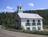
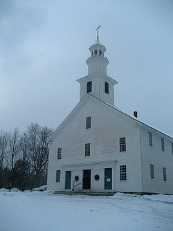
Historical landmarks
- Kents Corner
- Old West Church
- Maple Corner
- Robinson Saw Mill
- Adamant Co-op
Village history
Calais once had a village called SodomSodom and Gomorrah
Sodom and Gomorrah were cities mentioned in the Book of Genesis and later expounded upon throughout the Hebrew Bible, the New Testament and Deuterocanonical sources....
. This name was allegedly given because the village had no church, though it did have a few active quarries
Quarry
A quarry is a type of open-pit mine from which rock or minerals are extracted. Quarries are generally used for extracting building materials, such as dimension stone, construction aggregate, riprap, sand, and gravel. They are often collocated with concrete and asphalt plants due to the requirement...
. In 1905, the residents petitioned the state legislature to change the name to Adamant
Adamant
Adamant and similar words are used to refer to any especially hard substance, whether composed of diamond, some other gemstone, or some type of metal. Both adamant and diamond derive from the Greek word αδαμας , meaning "untameable"...
, chosen to suggest the hardness of granite.
Pekin is named after Peking (now Beijing
Beijing
Beijing , also known as Peking , is the capital of the People's Republic of China and one of the most populous cities in the world, with a population of 19,612,368 as of 2010. The city is the country's political, cultural, and educational center, and home to the headquarters for most of China's...
), China
China
Chinese civilization may refer to:* China for more general discussion of the country.* Chinese culture* Greater China, the transnational community of ethnic Chinese.* History of China* Sinosphere, the area historically affected by Chinese culture...
, the result of a local farmer who had a friend who was a missionary to China. The missionary sent some Chinese wheat back to Vermont, the farmer planted it, and it flourished. It became the style to give directions using the wheat field as a landmark ("up by the Pekin wheat", or "just past the Pekin wheat"). Eventually, the location of the field came to be known simply as Pekin. Another version suggests that the missionary sent back rice, and that the farmer planted the rice in a low-lying plain, which flooded each spring. The river came to be known as Peking Brook, later and presently Pekin Brook.
Geography
According to the United States Census BureauUnited States Census Bureau
The United States Census Bureau is the government agency that is responsible for the United States Census. It also gathers other national demographic and economic data...
, the town has a total area of 38.6 square miles (99.9 km2), of which 38.0 square miles (98.5 km2) is land and 0.6 square mile (1.5 km2) (1.45%) is water.
The following bodies of water are within the town: Curtis Pond, Nelson Pond, Bliss Pond, and #10 Pond, also known as Mirror Lake.
Demographics
As of the censusCensus
A census is the procedure of systematically acquiring and recording information about the members of a given population. It is a regularly occurring and official count of a particular population. The term is used mostly in connection with national population and housing censuses; other common...
of 2000, there were 1,529 people, 616 households, and 418 families residing in the town. The population density
Population density
Population density is a measurement of population per unit area or unit volume. It is frequently applied to living organisms, and particularly to humans...
was 40.2 people per square mile (15.5/km2). There were 773 housing units at an average density of 20.3 per square mile (7.8/km2). The racial makeup of the town was 96.08% White, 0.33% African American, 0.26% Native American, 0.20% Asian, 0.39% from other races
Race (United States Census)
Race and ethnicity in the United States Census, as defined by the Federal Office of Management and Budget and the United States Census Bureau, are self-identification data items in which residents choose the race or races with which they most closely identify, and indicate whether or not they are...
, and 2.75% from two or more races. Hispanic or Latino of any race were 0.39% of the population.
There were 616 households out of which 34.7% had children under the age of 18 living with them, 57.3% were married couples
Marriage
Marriage is a social union or legal contract between people that creates kinship. It is an institution in which interpersonal relationships, usually intimate and sexual, are acknowledged in a variety of ways, depending on the culture or subculture in which it is found...
living together, 6.8% had a female householder with no husband present, and 32.0% were non-families. 24.0% of all households were made up of individuals and 6.8% had someone living alone who was 65 years of age or older. The average household size was 2.48 and the average family size was 2.98.
In the town the population was spread out with 25.8% under the age of 18, 5.0% from 18 to 24, 26.3% from 25 to 44, 32.8% from 45 to 64, and 10.1% who were 65 years of age or older. The median age was 41 years. For every 100 females there were 98.3 males. For every 100 females age 18 and over, there were 100.4 males.
The median income for a household in the town was $46,083, and the median income for a family was $49,107. Males had a median income of $33,000 versus $27,917 for females. The per capita income
Per capita income
Per capita income or income per person is a measure of mean income within an economic aggregate, such as a country or city. It is calculated by taking a measure of all sources of income in the aggregate and dividing it by the total population...
for the town was $20,722. About 4.9% of families and 6.5% of the population were below the poverty line, including 7.9% of those under age 18 and 5.4% of those age 65 or over.
Further reading
- Miller, Peter. Vermont People. Vermont People Project: 1991. ISBN 0-9628064-0-4.
- Rodgers, Steve. Country Towns of Vermont. McGraw-Hill: 1998. ISBN 1-56626-195-3.
- Strickland, Ron. Vermonters: Oral Histories from Down Country to the Northeast Kingdom. University Press of New England: 1986. ISBN 0-87451-867-9.
- Swift, Esther Monroe. Vermont Place Names: Footprints of History. The Stephen Greene Press: 1996 ISBN 0-8289-0291-7.
- Van Susteren, Dirk, A Vermont Century: Photography and Essays from the Green Mountain State. Rutland Herald and Barre-Montpelier Times Argus: 1999. ISBN 0-932754-99-6.