
Buncton
Encyclopedia
Village
A village is a clustered human settlement or community, larger than a hamlet with the population ranging from a few hundred to a few thousand , Though often located in rural areas, the term urban village is also applied to certain urban neighbourhoods, such as the West Village in Manhattan, New...
in the Horsham
Horsham (district)
Horsham is a local government district in West Sussex, England. Its council is based in Horsham. The district borders those of Crawley, Mid Sussex, Mole Valley, Chichester, Arun and Adur....
District of West Sussex
West Sussex
West Sussex is a county in the south of England, bordering onto East Sussex , Hampshire and Surrey. The county of Sussex has been divided into East and West since the 12th century, and obtained separate county councils in 1888, but it remained a single ceremonial county until 1974 and the coming...
, England
England
England is a country that is part of the United Kingdom. It shares land borders with Scotland to the north and Wales to the west; the Irish Sea is to the north west, the Celtic Sea to the south west, with the North Sea to the east and the English Channel to the south separating it from continental...
, part of the civil parish
Civil parish
In England, a civil parish is a territorial designation and, where they are found, the lowest tier of local government below districts and counties...
of Wiston
Wiston, West Sussex
Wiston is a scattered village and civil parish in the Horsham District of West Sussex, England. It lies on the A283 road northwest of Steyning.The parish covers an area of...
. It lies to the east of the A24
A24 road (Great Britain)
The A24 is a major road in England. It runs south from Clapham in southwest London through Morden before entering Surrey and heading through Ewell, Epsom, Ashtead, Leatherhead and Dorking...
road, about 20 miles (32 km) south of Horsham
Horsham
Horsham is a market town with a population of 55,657 on the upper reaches of the River Arun in the centre of the Weald, West Sussex, in the historic County of Sussex, England. The town is south south-west of London, north-west of Brighton and north-east of the county town of Chichester...
.
Buncton existed as a settlement at the time of the Domesday survey
Domesday Book
Domesday Book , now held at The National Archives, Kew, Richmond upon Thames in South West London, is the record of the great survey of much of England and parts of Wales completed in 1086...
in 1086, when it was called Bongetune. Its origins lie in a manor
Manorialism
Manorialism, an essential element of feudal society, was the organizing principle of rural economy that originated in the villa system of the Late Roman Empire, was widely practiced in medieval western and parts of central Europe, and was slowly replaced by the advent of a money-based market...
whose land lay within two exclaves of the parish of Ashington
Ashington, West Sussex
Ashington is a village and civil parish in the Horsham District of West Sussex, England. It lies on the A24 road 3 miles northeast of Storrington.The parish has a land area of 805 hectares...
within the Rape of Bramber
Rape of Bramber
The Rape of Bramber is one of the rapes, the traditional sub-divisions unique to the historic county of Sussex in England. Bramber is a former barony, originally based around the castle of Bramber and its village, overlooking the river Adur.-History:...
, one of the six ancient subdivisions of Sussex. The medieval manor house
Manor house
A manor house is a country house that historically formed the administrative centre of a manor, the lowest unit of territorial organisation in the feudal system in Europe. The term is applied to country houses that belonged to the gentry and other grand stately homes...
has vanished, but a 17th-century replacement still stands.
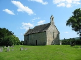
The most notable building in Buncton is All Saints Church
All Saints Church, Buncton
All Saints Church is an Anglican church in the hamlet of Buncton in the district of Horsham, one of seven local government districts in the English county of West Sussex. Built in the 11th or 12th century as a small chapel of ease to a nearby parish church, and hardly changed or restored since,...
. This 11th or 12th century structure is composed mainly of flint and rubble masonry with some fragments of tile salvaged from the earlier Roman building that existed nearby. The church was built by the monks of neighbouring Sele Priory
Upper Beeding
Upper Beeding is a village and civil parish in the Horsham District of West Sussex, England. It is located at the northern end of the River Adur gap in the South Downs four miles north of Shoreham-by-Sea and has a land area of 1877 hectares...
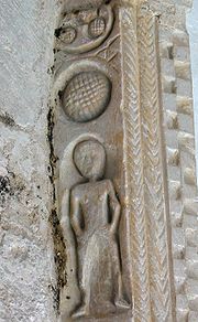
, and parts of the stonework show evidence of having been previously used at Sele. The church contained a curious carving, claimed by some to be an example of a sheela-na-gig, which was destroyed by an act of vandalism in 2004,.
Until 2007 All Saints' was a district Chapel of ease
Chapel of ease
A chapel of ease is a church building other than the parish church, built within the bounds of a parish for the attendance of those who cannot reach the parish church conveniently....
, subordinate to St Mary's Church at Wiston
Wiston, West Sussex
Wiston is a scattered village and civil parish in the Horsham District of West Sussex, England. It lies on the A283 road northwest of Steyning.The parish covers an area of...
, but in that year the status of the two buildings was reversed, with All Saints' becoming the Parish Church.
Buncton Tea Rooms (also known as Wiston Tea Rooms), next to the Post Office
Post office
A post office is a facility forming part of a postal system for the posting, receipt, sorting, handling, transmission or delivery of mail.Post offices offer mail-related services such as post office boxes, postage and packaging supplies...
, are a popular summer venue for local people, where a wide variety of chickens, ducks, and other domestic fowl roam in the gardens amidst the tea room tables.