
Bullenkuhle
Encyclopedia
Lower Saxony
Lower Saxony is a German state situated in north-western Germany and is second in area and fourth in population among the sixteen states of Germany...
. This strange biotope
Biotope
Biotope is an area of uniform environmental conditions providing a living place for a specific assemblage of plants and animals. Biotope is almost synonymous with the term habitat, but while the subject of a habitat is a species or a population, the subject of a biotope is a biological community.It...
and geotope
Geotope
Geotope is the geological component of the abiotic matrix present in an ecotope. Example geotopes might be: an exposed outcrop of rocks, an erratic boulder, a grotto or ravine, a cave, an old stone wall marking a property boundary, and so forth....
has been formed into a natural hollow in the terrain that is termed a sinkhole
Sinkhole
A sinkhole, also known as a sink, shake hole, swallow hole, swallet, doline or cenote, is a natural depression or hole in the Earth's surface caused by karst processes — the chemical dissolution of carbonate rocks or suffosion processes for example in sandstone...
. The area is environmentally protected.
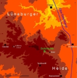
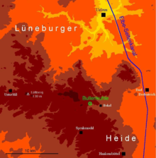
Location
The Bullenkuhle lies about 15 kilometres south of the town of UelzenUelzen
Uelzen is a town in northeast Lower Saxony, Germany, and capital of the county of Uelzen. It is part of the Hamburg Metropolitan Region, a Hanseatic town and an independent municipality....
and a good kilometre west of the village of Bokel (in the municipality of Sprakensehl
Sprakensehl
Sprakensehl is a municipality in the district of Gifhorn, in Lower Saxony, Germany....
) at the edge of a large pine forest at a height of about 95 metres (311.7 ft) above NN. A stream emerges in the immediate vicinity which is initially called the Bokeler Bach and, later, becomes the Aue and finally, after combining with other streams, becomes an Elbe
Elbe
The Elbe is one of the major rivers of Central Europe. It rises in the Krkonoše Mountains of the northwestern Czech Republic before traversing much of Bohemia , then Germany and flowing into the North Sea at Cuxhaven, 110 km northwest of Hamburg...
tributary, the River Ilmenau. The area belongs to the southeast fringes of the Hohen Heide in the centre of the Lüneburg Heath
Lüneburg Heath
The Lüneburg Heath is a large area of heath, geest and woodland in northeastern part of the state of Lower Saxony in northern Germany. It forms part of the hinterland for the cities of Hamburg, Hanover, and Bremen and is named after the town of Lüneburg. Most of the area is a nature reserve...
. This landscape formed from end and ground moraines and periglacial
Periglacial
Periglacial is an adjective originally referring to places in the edges of glacial areas, but it has later been widely used in geomorphology to describe any place where geomorphic processes related to freezing of water occur...
sediments was created geomorphologically mainly by the edges of the ice sheet during the later phases of the Saalian glaciation, i.e. during the so-called Drenthe II stage and the final glacial advance of the Warthe stage. The crests of the undulating ridges of end moraines are usually covered with pine forests growing on sandy soils; the ground moraines were used for agriculture. The typical open heath landscape of the Lüneburg Heath - which arose anthropogenically through overexploitation
Overexploitation
Overexploitation, also called overharvesting, refers to harvesting a renewable resource to the point of diminishing returns. Sustained overexploitation can lead to the destruction of the resource...
of forests, burning, plaggen cutting and grazing - only exists today in fragments in the area around the Bullenkuhle. The macroclimate of the Lüneburg Heath is maritime temperate
Köppen climate classification
The Köppen climate classification is one of the most widely used climate classification systems. It was first published by Crimea German climatologist Wladimir Köppen in 1884, with several later modifications by Köppen himself, notably in 1918 and 1936...
.
Formation of the sinkhole
Permian
The PermianThe term "Permian" was introduced into geology in 1841 by Sir Sir R. I. Murchison, president of the Geological Society of London, who identified typical strata in extensive Russian explorations undertaken with Edouard de Verneuil; Murchison asserted in 1841 that he named his "Permian...
period, which were later relocated and deformed tectonically. When rock salt comes into contact with ground water it leaches away; i.e. the salt is absorbed by the water and transported off. This can lead to the development of large underground caverns that finally cave in. Sometimes such an event at a depth of several hundred metres can result in the ground collapsing right up to the surface. This results in prominent, often steep-sided and deep hollows called sinkholes or doline
Doline
Doline can refer to:* Doline , a village in the Kanjiža municipality, Serbia.* Sinkhole, a natural depression or hole in the surface topography caused by the removal of soil or bedrock, often both, by water....
s (although dolines can have other morphogenetic causes, particularly in karst
KARST
Kilometer-square Area Radio Synthesis Telescope is a Chinese telescope project to which FAST is a forerunner. KARST is a set of large spherical reflectors on karst landforms, which are bowlshaped limestone sinkholes named after the Kras region in Slovenia and Northern Italy. It will consist of...
regions). Many of these funnel-shaped hollows remain dry, in others water collects that can later become marshy. Sinkholes are geologically often very recent; it is not uncommon for them to be only a few thousand years old and many hollows only date back a few hundred years.
Examples of sinkhole lakes and marshes include very large lakes like the Arendsee
Arendsee (lake)
The Arendsee is a natural lake in the Altmark region, northern Saxony-Anhalt, Germany. It is 23.3 m above sea level, and its area is 5.14 km², its depth nearly 50 m...
and the Zwischenahner Meer
Zwischenahner Meer
Zwischenahner Meer is a lake in Ammerland, Lower Saxony, Germany. At an elevation of ca. 5 m, its surface area is 5.5 km².- External links :...
– both at least 500 hectares in area – the Seeburger See
Seeburger See
Seeburger See is a lake in the karst region of Lower Eichsfeld, Landkreis Göttingen, in southeastern Lower Saxony, Germany.Also known as the Auge des Eichsfelds der grosser See bei Bernshausen , the shallow 86.5-hectare lake is fed in the west by the Aue creek at Seeburg and drained to the east...
, the Sager Meer in Oldenburg district, the Rudower See in Westprignitz district or the "bottomless marsh" (Grundloses Moor) in Soltau-Fallingbostel district and Maujahn in Lüchow-Dannenberg district. The Bullenkuhle belongs to this group, albeit considerably smaller. This sinkhole has a diameter of about 130 metres (426.5 ft) and attains a depth of 15 metres (49.2 ft). Exactly when the Bullenkuhle was formed is not known. This would need a stratigraphic investigation and pollen analysis
Pollen analysis
Analysis of the distribution of pollen grains of various species contained in surface layer deposits, especially peat bogs and lake sediments, from which a record of past climate may be inferred. Because the lake sediments accumulate over time, a core of the mud will show that the mud at the bottom...
of the vertical profile of the sinkhole (see Maujahn Moor
Maujahn Moor
The Maujahn or Maujahn Moor is a kettle bog in North Germany which began as a sinkhole...
).
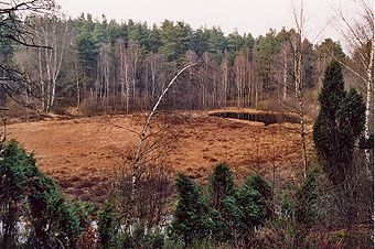
Description
The visitor to the Bullenkuhle comes across a basin-shaped hollow with steep sides of 30 to 60º in places. At the foot of the slopes of glacial sands is a marsh covering about 0.5 hectares (1.2 acre) that on closer inspection turns out to be a 'quaking bog' (Schwingrasen or Schwingmoor) - a floating mat of moss and other plants, under which there is presumably no homogeneous layer of peat, but at least in places just a body of water.The floating mat covers at least 80% of the wetland or marsh, only in the northeast is there stretch of open water about 0.1 hectare (0.247105163015276 acre) in area and several metres deep; a so-called bog pond. With an electrolytic conductivity
Conductivity (electrolytic)
The conductivity of an electrolyte solution is a measure of its ability to conduct electricity. The SI unit of conductivity is siemens per meter ....
of 24 µS/cm this wetland is very oligotrophic, it is rich in humus and, with a pH value of 5.0, moderately acidic. It is populated by typical marsh plants like peat mosses
Sphagnum
Sphagnum is a genus of between 151 and 350 species of mosses commonly called peat moss, due to its prevalence in peat bogs and mires. A distinction is made between sphagnum moss, the live moss growing on top of a peat bog on one hand, and sphagnum peat moss or sphagnum peat on the other, the...
, bladderworts and the rare Dwarf White Water Lily
Nymphaea candida
Nymphaea candida J. Presl is a species of aquatic perennial herbaceous plants in the genus Nymphaea native to quiet freshwater habitats in Eurasia, it is in flower from July to August. It is sometimes treated as a subspecies of N. alba Nymphaea candida J. Presl is a species of aquatic perennial...
(Nymphaea candida). In addition to peat mosses, the floating mat pressing in on the bog pond consists mainly of Hare's-tail Cottongrass
Eriophorum vaginatum
Eriophorum vaginatum L. is a species of perennial herbaceous plants in the family Cyperaceae, native to bogs and other acidic wetlands throughout the Holarctic Kingdom. It is a 30-60 cm high tussock-forming plant with erect solitary spikelets.-External links:* in Flora of North America*...
, Cross-leaved Heath
Erica tetralix
Erica tetralix is a species of heather found in Atlantic areas of Europe, from southern Portugal to central Norway, as well as a number of boggy regions further from the coast in Central Europe. In bogs, wet heaths and damp coniferous woodland, Erica tetralix can become a dominant part of the flora...
, Common Heather and Crowberry
Crowberry
Crowberry is a small genus of dwarf evergreen shrubs that bear edible fruit. They are commonly found in the northern hemisphere, from temperate to subarctic climates, and also in the Southern Andes of South America and on the South Atlantic islands of South Georgia, the Falklands and Tristan da...
; as well as White Beak-sedge
Rhynchospora alba
Rhynchospora alba, the white beak-sedge, is a plant in the sedge family, Cyperaceae. It is a tufted herbaceous perennial plant found in fairly acidic wetlands which have few plant nutrients....
and Cranberry
Cranberry
Cranberries are a group of evergreen dwarf shrubs or trailing vines in the subgenus Oxycoccus of the genus Vaccinium. In some methods of classification, Oxycoccus is regarded as a genus in its own right...
. The largely unwooded terrain can be described as flat to slightly rounded intermediate marsh (Zwischenmoor). On its periphery is a ring-shaped bog, which is slightly better supplied with nutrients from precipitation running down the slopes than the centre of the marsh. Bottle Sedge
Carex rostrata
Carex rostrata, bottle sedge, is a perennial species of sedge in the family Cyperaceae native to Holarctic fens....
reeds thrive particularly well here.
The slopes of the funnel-shaped terrain are covered with low vegetation such as Common Heather, Bilberry
Bilberry
Bilberry is any of several species of low-growing shrubs in the genus Vaccinium , bearing edible berries. The species most often referred to is Vaccinium myrtillus L., but there are several other closely related species....
, and Cranberry
Cranberry
Cranberries are a group of evergreen dwarf shrubs or trailing vines in the subgenus Oxycoccus of the genus Vaccinium. In some methods of classification, Oxycoccus is regarded as a genus in its own right...
, and also with Purple Moor Grass
Purple Moor Grass
Molinia caerulea is a perennial grass native to Europe, west Asia, and north Africa. It grows in locations from the lowlands up to 2,300 m in the Alps. Like most grasses, it grows best in acid soils, ideally pH values of between 3.5 and 5, however, it can continue to live under more extreme...
and trees. The latter include several very large and old Juniper
Juniper
Junipers are coniferous plants in the genus Juniperus of the cypress family Cupressaceae. Depending on taxonomic viewpoint, there are between 50-67 species of juniper, widely distributed throughout the northern hemisphere, from the Arctic, south to tropical Africa in the Old World, and to the...
bushes and trees, especially conspicuous and typical of the terrain. Other varieties include birch
Birch
Birch is a tree or shrub of the genus Betula , in the family Betulaceae, closely related to the beech/oak family, Fagaceae. The Betula genus contains 30–60 known taxa...
trees, Buckthorn
Buckthorn
The Buckthorns are a genus of about 100 species of shrubs or small trees from 1-10 m tall , in the buckthorn family Rhamnaceae...
bushes and pines. The animal world is also noteworthy and some species are peculiar to marsh biotope
Biotope
Biotope is an area of uniform environmental conditions providing a living place for a specific assemblage of plants and animals. Biotope is almost synonymous with the term habitat, but while the subject of a habitat is a species or a population, the subject of a biotope is a biological community.It...
s. In particular there are up to eight species of amphibian
Amphibian
Amphibians , are a class of vertebrate animals including animals such as toads, frogs, caecilians, and salamanders. They are characterized as non-amniote ectothermic tetrapods...
as well as adders
Vipera berus
Vipera berus, the common European adder or common European viper, is a venomous viper species that is extremely widespread and can be found throughout most of Western Europe and all the way to Far East Asia. Known by a host of common names including Common adder and Common viper, adders have been...
.
Literature
- J. Delfs: Die Bullenkuhle. In: Naturschutzgebiete im Raum Gifhorn-Wolfsburg. 1986
- R. Pott: Lüneburger Heide. Exkursionsführer Kulturlandschaften, Ulmer-Verlag, Stuttgart 1999, ISBN 3-8001-3515-9
- R. Tüxen: Die Bullenkuhle bei Bokel. Abhandl. naturwiss. Ver., Bremen 1958, 35/2: 374-394