
Bronte, Ontario
Encyclopedia
Bronte is the community that makes up much of the west end of Oakville
, in Ontario
, Canada
. Twelve Mile Creek
(known informally as Bronte Creek) flows through the middle of town and empties into Lake Ontario
. Main roads include Bronte Road (north-south), Lakeshore Road West (east-west, parallel to Lake Ontario) and Rebecca Street (east-west). Streets in the business section include Lakeshore, Jones, Marine, and Ontario Street. Bronte is also accessed via a superhighway (the Queen Elizabeth Way) located to the north of the former village. Riggs Road was planned but never opened. Other main roads include Third Line, Speers Road and Burloak Drive to the west (the latter was named after the boundary of Burlington and Oakville.)
Bronte is a former fishing village which became annexed in 1962 with the former Township of Trafalgar, forming the Town of Oakville, along with the other formerly autonomous communities, including Sheridan.

The urban area of Bronte is to the north, east and the southwest. The north-central part is industrialized while the west is mixed with some farmland, a former Petro-Canada refinery (which has closed and has yet to be dismantled as of 2010) and forests cover the northwest and includes Bronte Creek Provincial Park
which cuts off Upper Middle Road. The park area is also used for trailers and tents. Farmland used to cover most of Bronte (except for the northwest) before suburban housing came in the 1960s and the 1970s. Lakeshore houses are situated along the shore of Lake Ontario. The narrow ravine of Bronte Creek is undeveloped, except at the mouth which serves as a harbour.
in the south to the QEW. Coronation Park, which has a large playground, lots of parking space, a field room, and sandy beaches, hosts the annual Waterfront Festival. Its greatest attraction is an outdoor stage fronting an area 256 feet deep and 152 feet wide, with a hillock
at the side. During the Waterfront Festival, the east field has carnival rides such as 1001 Niches and Polar Express, and features game kiosks. The parking lot
is turned into a string of kiosk
s offering food and product information. The stage has extra lighting installed with a projector screen, an autograph booth at the side, and a DJ booth in the middle.
Rail and bus service operates from Bronte GO Station, situated on the Lakeshore West line connecting Bronte to communities along the shore, including Toronto
. Originally known as Oakville West, the station became known by its current name when it was rebuilt. The station boasts having more than 1,700 parking spaces and is located off Wyecroft Road with access from the South Service Road.
Bronte has a number of schools, including Queen Elizabeth Park (closed), Gladys Speers, Eastview and Brookdale (Public Elementary), St. Dominic and St. Joseph (Catholic Elementary), and Oakville Christian School, formerly John Wilson (Private Elementary). Thomas A. Blakelock (Public High) rounds out the list.
Although the commercial centre is at Bronte Road and Lakeshore, the Hopedale Mall located at Rebecca Street and Third Line Road provides additional retail businesses. Originally an L-shaped strip mall
built in 1959 coincident with the development of the surrounding subdivision, it has undergone several expansions by which it has been enclosed with the closing of Seabourne Street between Tansley Drive and Rebecca Street.
Founded in 1834, Bronte began as a small fishing village at the mouth of Twelve Mile Creek. The name Bronte was chosen as a tribute to the British Naval hero, Horatio Nelson, who was made Duke of Bronte by King Ferdinand III of Sicily. Bronte's etymological root is the Greek word βροντή which means thunder.
Some of Bronte's original settlers were United Empire Loyalists
and many of the streets were named for these founding fathers: Sovereign, Hixon, Nelson and Belyea.
One of the early industries in Bronte was stonehooking
. Boats would gather stone slabs from shallow waters near the shore by hooking them from Lake Ontario
for use in construction. The building at 49 Bronte Road built circa 1840 still remains as an example of construction using material stonehooked from the lake.
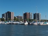
Bronte's first harbour was completed in 1856.
In the 1920s, Middle Road was built with 3 interchanges including Service Road. Middle Road became part of the Queen Elizabeth Way
(QEW) in 1939.
In the mid-20th century, Cities Service
built a refinery just south of the Queen Elizabeth Way
, west of Bronte Road. The refinery was later acquired by British Petroleum and subsequently, Petro-Canada
. Another refinery to the west was built by Shell
with its entrance off Rebecca Street. The Shell Refinery ceased operations in 198_. The Petro-Canada refinery was decommissioned in 2009 and now is a bulk storage facility.
Streets in Bronte are numbered from east to west and lettered from A to L (or N?) from north to south. A housing boom started in the late 1950s south of the QEW. Starting in the late-1980s, housing developments began north of the QEW and westward towards Burlington.
In the 1960s, a highway linking north to Milton (Highway 25) moved from Guelph Line to Bronte Road. Later in the 1980s, an interchange for Burloak was added. This major arterial route is now not legally a highway, but a "regional road" but is, in fact, called "The Veterans Highway."
In the 2000s, a new two-lane bridge was built to connect New Street at Mississaga Street and Rebecca Street at Bronte Road.
A community called Lakeshore Woods was built where the former Shell refinery was located. Construction began in the 2000s and is planned for completion by 2010.
In early March 2006, Stoneboats restaurant, which was partly located in one of Bronte's most historical buildings (built in circa 1840), suffered heavy fire damage and was rebuilt. A large portion of the historical part of the building was destroyed.
In summer 2008, Fernbrook Homes announced a new 10-storey condo project called The Shores at the intersection of Bronte and Ontario, overlooking the harbour and adjacent to the Stoneboats property.
In April 2009, the Bronte Business Improvement Association and the owners of the Bronte Village Mall presented a proposal for revitalizing the mall which includes residential, office and retail space, although it appears that the height of the new proposed structures does not conform to local bylaws.
Oakville, Ontario
Oakville is a town in Halton Region, on Lake Ontario in Southern Ontario, Canada, and is part of the Greater Toronto Area. As of the 2006 census the population was 165,613.-History:In 1793, Dundas Street was surveyed for a military road...
, in Ontario
Ontario
Ontario is a province of Canada, located in east-central Canada. It is Canada's most populous province and second largest in total area. It is home to the nation's most populous city, Toronto, and the nation's capital, Ottawa....
, Canada
Canada
Canada is a North American country consisting of ten provinces and three territories. Located in the northern part of the continent, it extends from the Atlantic Ocean in the east to the Pacific Ocean in the west, and northward into the Arctic Ocean...
. Twelve Mile Creek
Twelve Mile Creek (Ontario)
Twelve Mile Creek is a waterway located in the Niagara Peninsula of Ontario, Canada. Its headwaters are located in the town of Pelham, Ontario, encompassing some of the most unspoiled and natural areas of Niagara area. Its lower reaches flow through urban areas of Thorold, Ontario and St...
(known informally as Bronte Creek) flows through the middle of town and empties into Lake Ontario
Lake Ontario
Lake Ontario is one of the five Great Lakes of North America. It is bounded on the north and southwest by the Canadian province of Ontario, and on the south by the American state of New York. Ontario, Canada's most populous province, was named for the lake. In the Wyandot language, ontarío means...
. Main roads include Bronte Road (north-south), Lakeshore Road West (east-west, parallel to Lake Ontario) and Rebecca Street (east-west). Streets in the business section include Lakeshore, Jones, Marine, and Ontario Street. Bronte is also accessed via a superhighway (the Queen Elizabeth Way) located to the north of the former village. Riggs Road was planned but never opened. Other main roads include Third Line, Speers Road and Burloak Drive to the west (the latter was named after the boundary of Burlington and Oakville.)
Bronte is a former fishing village which became annexed in 1962 with the former Township of Trafalgar, forming the Town of Oakville, along with the other formerly autonomous communities, including Sheridan.
Nearest places
- BurlingtonBurlington, OntarioBurlington , is a city located in Halton Region at the western end of Lake Ontario. Burlington is part of the Greater Toronto Area, and is also included in the Hamilton Census Metropolitan Area. Physically, Burlington lies between the north shore of Lake Ontario and the Niagara Escarpment...
, west - MiltonMilton, OntarioMilton is a town in Southern Ontario, Canada, and part of the Halton Region in the Greater Toronto Area. Milton received a tremendous amount of awareness following the release of the results of the 2006 Census, which indicated that Milton is the fastest growing municipality in the Greater Golden...
, north - OakvilleOakville, OntarioOakville is a town in Halton Region, on Lake Ontario in Southern Ontario, Canada, and is part of the Greater Toronto Area. As of the 2006 census the population was 165,613.-History:In 1793, Dundas Street was surveyed for a military road...
, part of Oakville - TorontoTorontoToronto is the provincial capital of Ontario and the largest city in Canada. It is located in Southern Ontario on the northwestern shore of Lake Ontario. A relatively modern city, Toronto's history dates back to the late-18th century, when its land was first purchased by the British monarchy from...
, east - HamiltonHamilton, OntarioHamilton is a port city in the Canadian province of Ontario. Conceived by George Hamilton when he purchased the Durand farm shortly after the War of 1812, Hamilton has become the centre of a densely populated and industrialized region at the west end of Lake Ontario known as the Golden Horseshoe...
, Southwest
Geography and Information
- Population: about 10,000
- Area:
- density:
- Location: The southwest area within the Town of Oakville
- Latitude: about 43.6 N
- Longitude: about 79.85 W
- Area code: +1-905 (part of Oakville)
- Name of inhabitants: Brontonian sing., -s pl.
- Postal code: - L6L ---
The urban area of Bronte is to the north, east and the southwest. The north-central part is industrialized while the west is mixed with some farmland, a former Petro-Canada refinery (which has closed and has yet to be dismantled as of 2010) and forests cover the northwest and includes Bronte Creek Provincial Park
Bronte Creek Provincial Park
Bronte Creek Provincial Park is located in Oakville, Ontario, Canada, and is part of the Ontario Parks system.The park is located at the western edge of Oakville, bordering on Burlington. The park features hiking and biking trails, cross country skiing, and a play barn. During the summer,...
which cuts off Upper Middle Road. The park area is also used for trailers and tents. Farmland used to cover most of Bronte (except for the northwest) before suburban housing came in the 1960s and the 1970s. Lakeshore houses are situated along the shore of Lake Ontario. The narrow ravine of Bronte Creek is undeveloped, except at the mouth which serves as a harbour.
Culture and neighbourhood
Bronte's neighbourhood stretches from Burloak Drive in the west to Fourth Line, and from Lake OntarioLake Ontario
Lake Ontario is one of the five Great Lakes of North America. It is bounded on the north and southwest by the Canadian province of Ontario, and on the south by the American state of New York. Ontario, Canada's most populous province, was named for the lake. In the Wyandot language, ontarío means...
in the south to the QEW. Coronation Park, which has a large playground, lots of parking space, a field room, and sandy beaches, hosts the annual Waterfront Festival. Its greatest attraction is an outdoor stage fronting an area 256 feet deep and 152 feet wide, with a hillock
Hillock
A hillock or knoll is a small hill, usually separated from a larger group of hills such as a range. Hillocks are similar in their distribution and size to small mesas or buttes. The term is largely a British one...
at the side. During the Waterfront Festival, the east field has carnival rides such as 1001 Niches and Polar Express, and features game kiosks. The parking lot
Parking lot
A parking lot , also known as car lot, is a cleared area that is intended for parking vehicles. Usually, the term refers to a dedicated area that has been provided with a durable or semi-durable surface....
is turned into a string of kiosk
Kiosk
Kiosk is a small, separated garden pavilion open on some or all sides. Kiosks were common in Persia, India, Pakistan, and in the Ottoman Empire from the 13th century onward...
s offering food and product information. The stage has extra lighting installed with a projector screen, an autograph booth at the side, and a DJ booth in the middle.
Rail and bus service operates from Bronte GO Station, situated on the Lakeshore West line connecting Bronte to communities along the shore, including Toronto
Toronto
Toronto is the provincial capital of Ontario and the largest city in Canada. It is located in Southern Ontario on the northwestern shore of Lake Ontario. A relatively modern city, Toronto's history dates back to the late-18th century, when its land was first purchased by the British monarchy from...
. Originally known as Oakville West, the station became known by its current name when it was rebuilt. The station boasts having more than 1,700 parking spaces and is located off Wyecroft Road with access from the South Service Road.
Bronte has a number of schools, including Queen Elizabeth Park (closed), Gladys Speers, Eastview and Brookdale (Public Elementary), St. Dominic and St. Joseph (Catholic Elementary), and Oakville Christian School, formerly John Wilson (Private Elementary). Thomas A. Blakelock (Public High) rounds out the list.
Although the commercial centre is at Bronte Road and Lakeshore, the Hopedale Mall located at Rebecca Street and Third Line Road provides additional retail businesses. Originally an L-shaped strip mall
Strip mall
A strip mall is an open-area shopping center where the stores are arranged in a row, with a sidewalk in front. Strip malls are typically developed as a unit and have large parking lots in front...
built in 1959 coincident with the development of the surrounding subdivision, it has undergone several expansions by which it has been enclosed with the closing of Seabourne Street between Tansley Drive and Rebecca Street.
History
Founded in 1834, Bronte began as a small fishing village at the mouth of Twelve Mile Creek. The name Bronte was chosen as a tribute to the British Naval hero, Horatio Nelson, who was made Duke of Bronte by King Ferdinand III of Sicily. Bronte's etymological root is the Greek word βροντή which means thunder.
Some of Bronte's original settlers were United Empire Loyalists
United Empire Loyalists
The name United Empire Loyalists is an honorific given after the fact to those American Loyalists who resettled in British North America and other British Colonies as an act of fealty to King George III after the British defeat in the American Revolutionary War and prior to the Treaty of Paris...
and many of the streets were named for these founding fathers: Sovereign, Hixon, Nelson and Belyea.
One of the early industries in Bronte was stonehooking
Stonehooking
Stonehooking was a method of gathering stone slabs from the shallow lake shore in Southern Ontario destined primarily for building construction. It flourished as an industry from the mid-nineteenth century to the early twentieth century until the use of portland cement supplanted it as a building...
. Boats would gather stone slabs from shallow waters near the shore by hooking them from Lake Ontario
Lake Ontario
Lake Ontario is one of the five Great Lakes of North America. It is bounded on the north and southwest by the Canadian province of Ontario, and on the south by the American state of New York. Ontario, Canada's most populous province, was named for the lake. In the Wyandot language, ontarío means...
for use in construction. The building at 49 Bronte Road built circa 1840 still remains as an example of construction using material stonehooked from the lake.
Bronte's first harbour was completed in 1856.
In the 1920s, Middle Road was built with 3 interchanges including Service Road. Middle Road became part of the Queen Elizabeth Way
Queen Elizabeth Way
The Queen Elizabeth Way, commonly abbreviated as the QEW, is a 400-Series highway in the Canadian province of Ontario. The freeway links Buffalo, New York and the Niagara Peninsula with Toronto. It begins at the Peace Bridge in Fort Erie and travels around the western shore of Lake Ontario, ending...
(QEW) in 1939.
In the mid-20th century, Cities Service
Citgo
CITGO Petroleum Corporation is a United States-incorporated, Venezuela-owned refiner, transporter and marketer of transportation fuels, lubricants, petrochemicals and other industrial products. The company is owned by PDV America, Inc., an indirect wholly owned subsidiary of Petróleos de...
built a refinery just south of the Queen Elizabeth Way
Queen Elizabeth Way
The Queen Elizabeth Way, commonly abbreviated as the QEW, is a 400-Series highway in the Canadian province of Ontario. The freeway links Buffalo, New York and the Niagara Peninsula with Toronto. It begins at the Peace Bridge in Fort Erie and travels around the western shore of Lake Ontario, ending...
, west of Bronte Road. The refinery was later acquired by British Petroleum and subsequently, Petro-Canada
Petro-Canada
Petro-Canada was a crown corporation of Canada in the field of oil and natural gas. It was headquartered in the Petro-Canada Centre in Calgary, Alberta. In August, 2009, Petro-Canada merged with Suncor Energy, a deal in which Suncor investors received approximately 60 per cent ownership of the...
. Another refinery to the west was built by Shell
Royal Dutch Shell
Royal Dutch Shell plc , commonly known as Shell, is a global oil and gas company headquartered in The Hague, Netherlands and with its registered office in London, United Kingdom. It is the fifth-largest company in the world according to a composite measure by Forbes magazine and one of the six...
with its entrance off Rebecca Street. The Shell Refinery ceased operations in 198_. The Petro-Canada refinery was decommissioned in 2009 and now is a bulk storage facility.
Streets in Bronte are numbered from east to west and lettered from A to L (or N?) from north to south. A housing boom started in the late 1950s south of the QEW. Starting in the late-1980s, housing developments began north of the QEW and westward towards Burlington.
In the 1960s, a highway linking north to Milton (Highway 25) moved from Guelph Line to Bronte Road. Later in the 1980s, an interchange for Burloak was added. This major arterial route is now not legally a highway, but a "regional road" but is, in fact, called "The Veterans Highway."
In the 2000s, a new two-lane bridge was built to connect New Street at Mississaga Street and Rebecca Street at Bronte Road.
A community called Lakeshore Woods was built where the former Shell refinery was located. Construction began in the 2000s and is planned for completion by 2010.
In early March 2006, Stoneboats restaurant, which was partly located in one of Bronte's most historical buildings (built in circa 1840), suffered heavy fire damage and was rebuilt. A large portion of the historical part of the building was destroyed.
In summer 2008, Fernbrook Homes announced a new 10-storey condo project called The Shores at the intersection of Bronte and Ontario, overlooking the harbour and adjacent to the Stoneboats property.
In April 2009, the Bronte Business Improvement Association and the owners of the Bronte Village Mall presented a proposal for revitalizing the mall which includes residential, office and retail space, although it appears that the height of the new proposed structures does not conform to local bylaws.
External links
- Official Bronte Village website - with news, Bronte area event calendar, history, business directory, virtual map, community listings, and much more
- Bronte Harbour Yacht Club
- Bronte Outer Harbour Marina
- Town of Oakville
- Bronte Historical Society and Sovereign House
- Bronte at Geographical Names of Canada