
.gif)
Albert Street (Ottawa)
Encyclopedia
Albert Street is one of the main east-west roads in downtown Ottawa
, Canada
. Albert is one way
going west. It carries the westbound portion of the transitway
through downtown, with Slater Street
just to the south carrying the eastbound portion. Previously, it was planned that O-Train would have been extended to downtown running westbound along Albert.
 Albert Street begins at Elgin Street
, where traffic coming off the Mackenzie King Bridge
is divided between Albert and Slater. This is just east of Confederation Park
and the National Arts Centre
. In downtown Albert is lined mainly by government office towers and other facilities such as Constitution Square
, but the area become more residential. This area is also home to the former Ottawa Technical High School
. At Bronson Avenue Albert turns to the south, as it plunges down "Nanny Goat Hill". The Transitway separates from Albert and Slater Street merges into it at the bottom of this hill. Until 2006, Albert Street officially ended just west of Booth Street, where it merged imperceptibly with a rump section of Wellington Street
, but with Wellington rerouted past the Canadian War Museum
, Albert now continues until past the Bayview O-Train Station
, where it becomes Scott Street.
Ottawa
Ottawa is the capital of Canada, the second largest city in the Province of Ontario, and the fourth largest city in the country. The city is located on the south bank of the Ottawa River in the eastern portion of Southern Ontario...
, Canada
Canada
Canada is a North American country consisting of ten provinces and three territories. Located in the northern part of the continent, it extends from the Atlantic Ocean in the east to the Pacific Ocean in the west, and northward into the Arctic Ocean...
. Albert is one way
One-way traffic
One-way traffic is traffic that moves in a single direction. A one-way street is a street either facilitating only one-way traffic, or designed to direct vehicles to move in one direction.-General signs:...
going west. It carries the westbound portion of the transitway
Ottawa Rapid Transit
In Ottawa, Ontario, Canada, the public transit service operated by OC Transpo has two rapid transit systems: the Transitway, a bus rapid transit network, and the O-Train, a diesel-powered light rail transit service operated on one line.-Major routes:...
through downtown, with Slater Street
Slater Street
Slater Street is one of the main east-west roads in downtown Ottawa, Canada. Slater is one way going east. It carries the eastbound portion of the Transitway through downtown, with Albert Street just to the north carrying the westbound portion...
just to the south carrying the eastbound portion. Previously, it was planned that O-Train would have been extended to downtown running westbound along Albert.
Elgin Street (Ottawa)
Elgin Street is a street in the Golden Triangle of Ottawa, Ontario, Canada. Originally named Biddy's Lane, it was later named after Lord Elgin....
, where traffic coming off the Mackenzie King Bridge
Mackenzie King Bridge
The Mackenzie King Bridge is a bridge in Ottawa, Ontario, Canada. Just a few blocks away from Parliament Hill, south of the Plaza Bridge, it runs in a generally east-west direction, with the east end at the Rideau Centre and Department of National Defence Headquarters. The west end runs between...
is divided between Albert and Slater. This is just east of Confederation Park
Confederation Park
Confederation Park is a park in downtown Ottawa and a National Historic Site of Canada. It is bordered on the south by Laurier Avenue and Ottawa City Hall; on the east by the Rideau Canal; on the north by the Mackenzie King Bridge, the Rideau Centre and the National Arts Centre; and, to the west,...
and the National Arts Centre
National Arts Centre
The National Arts Centre is a centre for the performing arts located in Ottawa, Ontario, between Elgin Street and the Rideau Canal...
. In downtown Albert is lined mainly by government office towers and other facilities such as Constitution Square
Constitution Square (Ottawa)
Constitution Square is a three-tower office complex, located in downtown Ottawa, Ontario at 340-360 Albert Street. It is home to a variety of businesses, organizations and embassies....
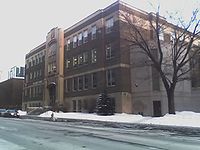
, but the area become more residential. This area is also home to the former Ottawa Technical High School
Ottawa Technical High School
Ottawa Technical High School, more often known as Ottawa Tech, was a high school in Ottawa, Canada that originally specialized in vocational programs. The school opened in 1913 as the second public secondary school in Ottawa, and was closed in 1992. It was located on Albert Street in the western...
. At Bronson Avenue Albert turns to the south, as it plunges down "Nanny Goat Hill". The Transitway separates from Albert and Slater Street merges into it at the bottom of this hill. Until 2006, Albert Street officially ended just west of Booth Street, where it merged imperceptibly with a rump section of Wellington Street
Wellington Street (Ottawa)
Wellington Street is an important street in Ottawa, Canada most notable for being one of the first two streets laid out in Bytown in 1826 Wellington Street (French: Rue Wellington) is an important street in Ottawa, Canada most notable for being one of the first two streets laid out in Bytown in...
, but with Wellington rerouted past the Canadian War Museum
Canadian War Museum
The Canadian War Museum is Canada’s national museum of military history. Located in Ottawa, Ontario, the museum covers all facets of Canada’s military past, from the first recorded instances of death by armed violence in Canadian history several thousand years ago to the country’s most recent...
, Albert now continues until past the Bayview O-Train Station
Bayview Station (OC Transpo)
Bayview Station is a transitway and O-Train station in Ottawa, Ontario. The bus stop is at the eastern end of Scott Street when it becomes Wellington Street. The O-Train station, the northern terminus of the current line, is located on a stub-end track branching off from the railway line,...
, where it becomes Scott Street.