
Brockweir
Encyclopedia
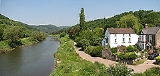
Brockweir is a small village on the eastern bank of the River Wye
, within the Forest of Dean
, Gloucestershire
, England
. A road bridge links it across the river to Monmouthshire
, Wales
, about a mile (1.6 km) outside the village of Tintern
and 7½ miles (12 km) north of Chepstow
. The village is close to both the Offa's Dyke Path
and the Wye Valley Walk
.
priory and later Tintern Abbey
; its remains can be seen as shallows under Brockweir bridge.
The village existed from at least the 13th century, as a hamlet within the parish
of Hewelsfield
. The oldest existing building, the Malthouse, dates in part from the 15th century and probably formed part of a grange owned by Tintern Abbey. Another house, the Manor House, dates from about 1600, and many other houses date from the 18th century.
For centuries Brockweir had a thriving shipbuilding, fitting-out and repair industry. Brockweir was the highest point reached by a normal tide on the Wye, and a key transhipment point where the cargoes of sea-going ships of up to 90 tonnes were transferred onto barges to be sent upstream, and the products of Herefordshire
and the Forest of Dean were sent back to Bristol
and beyond. In 1587, one resident, John Gethin, was killed on his boat in the Bristol Channel
in an affray with Bristol merchants.
According to some sources, in the early 19th century the village was thought to be one of the most lawless places in the country. Its reputation was earned by having about 16 public houses, to cater for the stevedores who were employed to load and unload the ships at the quayside. Only one narrow road led into the village, and goods were usually carried by donkeys or by water, with a ferry taking travellers to and from the Welsh bank of the Wye In 1833 the Duke of Beaufort issued an edict for the Moravian Church to be set up in the village because of its lawless reputation, and the church was built on the site of a former cock fighting pit. The first minister was Lewis West, who drew congregations of up to 200 people. The minister described the life of its watermen as being centred on beerhouses, skittle alleys, and cockfighting, and said that it had the reputation of a "city of refuge" for lawless elements. The church was rebuilt later in the 19th century.
Several chapels, a school, the decline of its trade, and an influx of outsiders to the area gradually changed the character of the village. During the early 20th century several Nonconformist groups, including Quakers, Pentecostalists, and Christian Scientists, held meetings in Brockweir and the surrounding area. The cast iron
road bridge was built in Chepstow
by Edward Finch & Co., and was opened in 1906. The last ship to sail to Brockweir was the Belle Marie in 1914, and the last Wye trows were built in the village in 1925. In 1929 Brockweir Halt
was opened on the Wye Valley Railway
on the Monmouthshire side of the bridge. The halt closed in 1959.
The writer Flora Klickmann
(1867–1958), who wrote several popular books about her experiences of living in the Wye valley as well as on other subjects, is buried at Brockweir.
in December 2004, when he described the project as "a triumph of community spirit".
The community shop includes a café, general store and food outlet, post office, library kiosk, art gallery and IT training suite. The building is of traditional oak construction combined with sustainable technology, and aims to be environmentally friendly with photovoltaic roof shingles producing electricity, the excess from which is exported back to the national grid. The building also has a geothermal heating system, drawing energy from the ground under the village playing field.
River Wye
The River Wye is the fifth-longest river in the UK and for parts of its length forms part of the border between England and Wales. It is important for nature conservation and recreation.-Description:...
, within the Forest of Dean
Forest of Dean
The Forest of Dean is a geographical, historical and cultural region in the western part of the county of Gloucestershire, England. The forest is a roughly triangular plateau bounded by the River Wye to the west and north, the River Severn to the south, and the City of Gloucester to the east.The...
, Gloucestershire
Gloucestershire
Gloucestershire is a county in South West England. The county comprises part of the Cotswold Hills, part of the flat fertile valley of the River Severn, and the entire Forest of Dean....
, England
England
England is a country that is part of the United Kingdom. It shares land borders with Scotland to the north and Wales to the west; the Irish Sea is to the north west, the Celtic Sea to the south west, with the North Sea to the east and the English Channel to the south separating it from continental...
. A road bridge links it across the river to Monmouthshire
Monmouthshire
Monmouthshire is a county in south east Wales. The name derives from the historic county of Monmouthshire which covered a much larger area. The largest town is Abergavenny. There are many castles in Monmouthshire .-Historic county:...
, Wales
Wales
Wales is a country that is part of the United Kingdom and the island of Great Britain, bordered by England to its east and the Atlantic Ocean and Irish Sea to its west. It has a population of three million, and a total area of 20,779 km²...
, about a mile (1.6 km) outside the village of Tintern
Tintern
Tintern is a village on the west bank of the River Wye in Monmouthshire, Wales, close to the border with England, about 5 miles north of Chepstow...
and 7½ miles (12 km) north of Chepstow
Chepstow
Chepstow is a town in Monmouthshire, Wales, adjoining the border with Gloucestershire, England. It is located on the River Wye, close to its confluence with the River Severn, and close to the western end of the Severn Bridge on the M48 motorway...
. The village is close to both the Offa's Dyke Path
Offa's Dyke Path
Offa's Dyke Path is a long distance footpath along the Welsh-English border. Opened in 1971, it is one of Britain's premier National Trails and draws walkers from throughout the world...
and the Wye Valley Walk
Wye Valley Walk
The Wye Valley Walk is a long distance footpath in Wales and England following the course of the River Wye .-Distance:The whole route now that it has been extended runs for 136 miles .-The route:...
.
History
The name Brockweir dates from about the 7th century; previously it was known in Welsh as Pwll Brochuail, the pool of Brochuail or Brockmael, a prince of Gwent. The weir was owned by MonmouthMonmouth
Monmouth is a town in southeast Wales and traditional county town of the historic county of Monmouthshire. It is situated close to the border with England, where the River Monnow meets the River Wye with bridges over both....
priory and later Tintern Abbey
Tintern Abbey
Tintern Abbey was founded by Walter de Clare, Lord of Chepstow, on 9 May 1131. It is situated in the village of Tintern, on the Welsh bank of the River Wye in Monmouthshire, which forms the border between Monmouthshire in Wales and Gloucestershire in England. It was only the second Cistercian...
; its remains can be seen as shallows under Brockweir bridge.
The village existed from at least the 13th century, as a hamlet within the parish
Parish
A parish is a territorial unit historically under the pastoral care and clerical jurisdiction of one parish priest, who might be assisted in his pastoral duties by a curate or curates - also priests but not the parish priest - from a more or less central parish church with its associated organization...
of Hewelsfield
Hewelsfield
Hewelsfield is a village and parish in the Forest of Dean District of Gloucestershire, England. It is located 6 miles south of Coleford and 5 miles north-east of Chepstow, close to the Wye valley and partly within an Area of Outstanding Natural Beauty. The parish also includes the separate...
. The oldest existing building, the Malthouse, dates in part from the 15th century and probably formed part of a grange owned by Tintern Abbey. Another house, the Manor House, dates from about 1600, and many other houses date from the 18th century.
For centuries Brockweir had a thriving shipbuilding, fitting-out and repair industry. Brockweir was the highest point reached by a normal tide on the Wye, and a key transhipment point where the cargoes of sea-going ships of up to 90 tonnes were transferred onto barges to be sent upstream, and the products of Herefordshire
Herefordshire
Herefordshire is a historic and ceremonial county in the West Midlands region of England. For Eurostat purposes it is a NUTS 3 region and is one of three counties that comprise the "Herefordshire, Worcestershire and Gloucestershire" NUTS 2 region. It also forms a unitary district known as the...
and the Forest of Dean were sent back to Bristol
Bristol
Bristol is a city, unitary authority area and ceremonial county in South West England, with an estimated population of 433,100 for the unitary authority in 2009, and a surrounding Larger Urban Zone with an estimated 1,070,000 residents in 2007...
and beyond. In 1587, one resident, John Gethin, was killed on his boat in the Bristol Channel
Bristol Channel
The Bristol Channel is a major inlet in the island of Great Britain, separating South Wales from Devon and Somerset in South West England. It extends from the lower estuary of the River Severn to the North Atlantic Ocean...
in an affray with Bristol merchants.
According to some sources, in the early 19th century the village was thought to be one of the most lawless places in the country. Its reputation was earned by having about 16 public houses, to cater for the stevedores who were employed to load and unload the ships at the quayside. Only one narrow road led into the village, and goods were usually carried by donkeys or by water, with a ferry taking travellers to and from the Welsh bank of the Wye In 1833 the Duke of Beaufort issued an edict for the Moravian Church to be set up in the village because of its lawless reputation, and the church was built on the site of a former cock fighting pit. The first minister was Lewis West, who drew congregations of up to 200 people. The minister described the life of its watermen as being centred on beerhouses, skittle alleys, and cockfighting, and said that it had the reputation of a "city of refuge" for lawless elements. The church was rebuilt later in the 19th century.
Several chapels, a school, the decline of its trade, and an influx of outsiders to the area gradually changed the character of the village. During the early 20th century several Nonconformist groups, including Quakers, Pentecostalists, and Christian Scientists, held meetings in Brockweir and the surrounding area. The cast iron
Cast iron
Cast iron is derived from pig iron, and while it usually refers to gray iron, it also identifies a large group of ferrous alloys which solidify with a eutectic. The color of a fractured surface can be used to identify an alloy. White cast iron is named after its white surface when fractured, due...
road bridge was built in Chepstow
Chepstow
Chepstow is a town in Monmouthshire, Wales, adjoining the border with Gloucestershire, England. It is located on the River Wye, close to its confluence with the River Severn, and close to the western end of the Severn Bridge on the M48 motorway...
by Edward Finch & Co., and was opened in 1906. The last ship to sail to Brockweir was the Belle Marie in 1914, and the last Wye trows were built in the village in 1925. In 1929 Brockweir Halt
Brockweir Halt railway station
Brockweir Halt was a request stop on the former Wye Valley Railway. It was opened to the public on 23 September 1929, it closed in 1959 when passenger services were withdrawn from the line. It was situated just north of Brockweir bridge. Nothing now remains of the trackbed because of the...
was opened on the Wye Valley Railway
Wye Valley Railway
The Wye Valley Railway was a standard gauge railway that ran for nearly between Chepstow and Monmouth along the lower part of the scenic Wye Valley in Monmouthshire, Wales, and Gloucestershire, England. It followed the route of the River Wye for most of its length...
on the Monmouthshire side of the bridge. The halt closed in 1959.
The writer Flora Klickmann
Flora Klickmann
Emily Flora Klickmann was an English journalist, author and editor. She was the second editor of the Girl's Own Paper, but became best known for her Flower-Patch series of books of anecdotes, autobiography and nature description.-Life:Flora Klickmann was born in Brixton, London, one of six children...
(1867–1958), who wrote several popular books about her experiences of living in the Wye valley as well as on other subjects, is buried at Brockweir.
Village Community Shop
The Brockweir and Hewelsfield Village Shop and Cafe is established as a non-profit making community enterprise, staffed by volunteers from the local community. It was opened by the Prince of WalesCharles, Prince of Wales
Prince Charles, Prince of Wales is the heir apparent and eldest son of Queen Elizabeth II and Prince Philip, Duke of Edinburgh. Since 1958 his major title has been His Royal Highness The Prince of Wales. In Scotland he is additionally known as The Duke of Rothesay...
in December 2004, when he described the project as "a triumph of community spirit".
The community shop includes a café, general store and food outlet, post office, library kiosk, art gallery and IT training suite. The building is of traditional oak construction combined with sustainable technology, and aims to be environmentally friendly with photovoltaic roof shingles producing electricity, the excess from which is exported back to the national grid. The building also has a geothermal heating system, drawing energy from the ground under the village playing field.