

Bristol and Bath railway path
Encyclopedia
The Bristol and Bath Railway Path is a 15 miles (24.1 km) off-road cycleway that forms part of National Cycle Network
National Cycle Route 4
. The path consists of a 3 metres (9.8 ft) wide tarmacked surface, and was used for 2.4 million trips in 2007, increasing by 10% per year.
The cycleway was built by the cycling charity Sustrans
between 1979 and 1986. Sustrans leased a five-mile stretch of this route, near Saltford
, with the help of the then Avon County Council
, and using volunteer effort turned it into their first cycleway.
Mangotsfield and Bath Branch Line
from Lawrence Hill
in central Bristol
to Newbridge
in Bath, which was closed during the Beeching Axe
of the 1960s, in favour of the more direct former Great Western Railway
between the cities. The route passes from Bristol towards Bath through the urban suburbs of Easton
, Fishponds, and Staple Hill, then the villages of Mangotsfield
, Warmley
, Bitton
and Saltford
before ending at Newbridge in Bath.
the Bristol suburbs of Easton, Fish
 The path starts at Trinity Street, Lawrence Hill. 51.456104°N 2.575019°W
. On the one remaining platform there is a modern sculptured seat. The path rises up level with the platform, and then drops back down to the track bed.
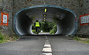
A short distance from the station is the entrance to Staple Hill Tunnel, a 0.3-mile-long tunnel under Staple Hill. The west end of the tunnel is located at 51.4792°N 2.51126°W, and the east end is located at 51.4789°N 2.50439°W.
The path takes up less than half the width of the tunnel, with the rest of the floor uneven rocks. The tunnel is lit all year-round, and despite the warning signs, 24 hours a day. The roof leaks in places, giving the appearance of rain, often when outside it is dry.
 Mangotsfield railway station
51.4757°N 2.4830°W was a station on the Midland Railway
Bristol and Gloucester
main line. The station was the junction for the Mangotsfield and Bath Branch Line
that led to Bath Green Park railway station
. Originally it had six platforms.
The disused Bristol and Gloucester route to Yate
now provides a spur from the railway path northwest to the Bristol ring road cycle path and Emersons Green
.
The remaining island platforms have railway related sculptures between them, some depicting waiting passengers. One notable sculpture was that of a suitcase, supposedly belonging to one of the passengers at that station. However, this unexpectedly disappeared from the station in the summer of 2008.
s.
contains a cafe, serving refreshments 7 days a week from Easter to September, weekends September to Easter as well as public toilets.
 Between Avon Riverside
and Oldland Common
railway stations, the path shares its route with the heritage
Avon Valley Railway
. Along the two mile shared section, the path crosses the railway line at two level crossings. There has been opposition to the Avon Valley Railway expanding their line demonstrated by the painting of graffiti along the path where it runs parallel with the line.
The railway's cafe at Bitton railway station
is open all year round to users of the path.
The west Bath river side path continues from there to the city centre of Bath.
and Bristol City Centre into a Guided Busway.
Sustrans have announced that they will oppose these plans, claiming that they are the "right idea, wrong route".
A petition against this proposal on Bristol City Council's website gained over 7900 signatures within the first month. A website was set up by a group opposed to the plans. In a council meeting on 1 April, plans for the busway were put on hold, but the council refused to completely rule out using the path for a busway at a later date.
National Cycle Network
The National Cycle Network is a network of cycle routes in the United Kingdom.The National Cycle Network was created by the charity Sustrans , and aided by a £42.5 million National Lottery grant. In 2005 it was used for over 230 million trips.Many routes hope to minimise contact with motor...
National Cycle Route 4
NCR 4
Between London and Fishguard, the route runs through Reading, Bath, Bristol, Newport, Swansea, Llanelli and St David's. Within Wales, NCR 4 forms one of the branches of the Celtic Trail cycle route.-London to Reading:Chertsey | Staines | Eton | Maidenhead...
. The path consists of a 3 metres (9.8 ft) wide tarmacked surface, and was used for 2.4 million trips in 2007, increasing by 10% per year.
The cycleway was built by the cycling charity Sustrans
Sustrans
Sustrans is a British charity to promote sustainable transport. The charity is currently working on a number of practical projects to encourage people to walk, cycle and use public transport, to give people the choice of "travelling in ways that benefit their health and the environment"...
between 1979 and 1986. Sustrans leased a five-mile stretch of this route, near Saltford
Saltford
Saltford is a large village and civil parish in the Bath and North East Somerset unitary authority, Somerset, England. It lies between the cities of Bristol and Bath....
, with the help of the then Avon County Council
Avon County Council
Avon County Council was the county council of the non-metropolitan county of Avon in south west England. It came into its powers on 1 April 1974 and was abolished on 1 April 1996 at the same time as the county. The county council was based in Bristol at Avon House and Avon House North...
, and using volunteer effort turned it into their first cycleway.
Route
The path follows the route of the Midland RailwayMidland Railway
The Midland Railway was a railway company in the United Kingdom from 1844 to 1922, when it became part of the London, Midland and Scottish Railway....
Mangotsfield and Bath Branch Line
Mangotsfield and Bath Branch Line
The Mangotsfield and Bath Branch Line opened in 1869 to connect Bath to the Midland Railway network at Mangotsfield, on the former Bristol and Gloucester Railway....
from Lawrence Hill
Lawrence Hill, Bristol
Lawrence Hill is an electoral ward of Bristol, United Kingdom. It takes its name from a small area just to the east of the city centre, and includes the districts of Barton Hill, St Philips Marsh and Redcliffe, Temple Meads and parts of Easton and the Broadmead shopping area.-History:It is the most...
in central Bristol
Bristol
Bristol is a city, unitary authority area and ceremonial county in South West England, with an estimated population of 433,100 for the unitary authority in 2009, and a surrounding Larger Urban Zone with an estimated 1,070,000 residents in 2007...
to Newbridge
Newbridge, Bath
Newbridge is a largely residential electoral ward within Bath, England. Informally, Newbridge refers to the area of Bath that roughly corresponds to the ward boundaries....
in Bath, which was closed during the Beeching Axe
Beeching Axe
The Beeching Axe or the Beeching Cuts are informal names for the British Government's attempt in the 1960s to reduce the cost of running British Railways, the nationalised railway system in the United Kingdom. The name is that of the main author of The Reshaping of British Railways, Dr Richard...
of the 1960s, in favour of the more direct former Great Western Railway
Great Western Railway
The Great Western Railway was a British railway company that linked London with the south-west and west of England and most of Wales. It was founded in 1833, received its enabling Act of Parliament in 1835 and ran its first trains in 1838...
between the cities. The route passes from Bristol towards Bath through the urban suburbs of Easton
Easton, Bristol
Easton is both the name of a council ward in the city of Bristol in the United Kingdom, and an inner city area that lies partly within that ward. The Easton ward also contains the Whitehall and Netham areas of the city. Notable places within the ward include Lawrence Hill and Stapleton Road railway...
, Fishponds, and Staple Hill, then the villages of Mangotsfield
Mangotsfield
Mangotsfield is a village in South Gloucestershire, England, situated north of the Bristol suburb of Kingswood, bounded to the north by the M4 motorway and to the east by the Emersons Green housing estate....
, Warmley
Warmley
Warmley is a village in South Gloucestershire, England, to the east of Kingswood on the outskirts of Bristol.In the mid 18th century it contained the Warmley Works of William Champion...
, Bitton
Bitton
Bitton is a village and civil parish in South Gloucestershire, England, in the Greater Bristol area on the River Boyd.It is in the far south of the South Gloucestershire district, near the border with Bath and North East Somerset...
and Saltford
Saltford
Saltford is a large village and civil parish in the Bath and North East Somerset unitary authority, Somerset, England. It lies between the cities of Bristol and Bath....
before ending at Newbridge in Bath.
the Bristol suburbs of Easton, Fish
Bristol end
Clay Bottom
A housing development at Clay Bottom (near the B4469) has encroached onto the original alignment of the railway, the cycleway diverts around several houses at this point causing a blind corner. These houses would be in the way of any future use of this section as a guided busway or rail use.Staple Hill
3.2 miles from the Bristol End, the path reaches Staple Hill stationStaple Hill railway station
Staple Hill railway station was on the Midland Railway line between Bristol and Gloucester on the outskirts of Bristol. The station was on the Bristol and Gloucester Railway line, but opened in 1888, 44 years after the line had been opened through the site...
. On the one remaining platform there is a modern sculptured seat. The path rises up level with the platform, and then drops back down to the track bed.
A short distance from the station is the entrance to Staple Hill Tunnel, a 0.3-mile-long tunnel under Staple Hill. The west end of the tunnel is located at 51.4792°N 2.51126°W, and the east end is located at 51.4789°N 2.50439°W.
The path takes up less than half the width of the tunnel, with the rest of the floor uneven rocks. The tunnel is lit all year-round, and despite the warning signs, 24 hours a day. The roof leaks in places, giving the appearance of rain, often when outside it is dry.
Mangotsfield station
Mangotsfield railway station
Mangotsfield railway station was a station on the Midland Railway Bristol and Gloucester main line and was situated about five miles to the north east of Bristol in what is now the suburb of Mangotsfield....
51.4757°N 2.4830°W was a station on the Midland Railway
Midland Railway
The Midland Railway was a railway company in the United Kingdom from 1844 to 1922, when it became part of the London, Midland and Scottish Railway....
Bristol and Gloucester
Bristol and Gloucester Railway
The Bristol and Gloucester Railway opened in 1844 between Bristol and Gloucester, meeting the Birmingham and Gloucester Railway. It is now part of the main line from the North-East of England through Derby and Birmingham to the South-West.-History:...
main line. The station was the junction for the Mangotsfield and Bath Branch Line
Mangotsfield and Bath Branch Line
The Mangotsfield and Bath Branch Line opened in 1869 to connect Bath to the Midland Railway network at Mangotsfield, on the former Bristol and Gloucester Railway....
that led to Bath Green Park railway station
Bath Green Park railway station
Green Park railway station is a former railway station in Bath, Somerset, England. For some of its life, it was known as Bath Queen Square.-Architecture and opening:...
. Originally it had six platforms.
The disused Bristol and Gloucester route to Yate
Yate
Yate is a town in South Gloucestershire, England, at the southwest extremity of the Cotswold Hills, 12 miles northeast of the city of Bristol. At the 2001 census the population was 21,789. The town of Chipping Sodbury is continuous with Yate to the east...
now provides a spur from the railway path northwest to the Bristol ring road cycle path and Emersons Green
Emersons Green
Emersons Green is a residential area on the northern outskirts of Bristol, England. It was developed from farming land during the 1990s and early 21st century, and sits between the historic villages of Mangotsfield and Downend...
.
The remaining island platforms have railway related sculptures between them, some depicting waiting passengers. One notable sculpture was that of a suitcase, supposedly belonging to one of the passengers at that station. However, this unexpectedly disappeared from the station in the summer of 2008.
Avon ring road
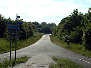
From 1999 to July 2001, South Gloucestershire Council built a new section of the A4174 Avon ring road, along part of the railway path. Whilst the work was being under taken the path was diverted away from the route of the old railway line. A new section of path was added around the ring road which increases the length of the railway path by 200 yards. The new section includes two bridges, several tight corners, a hill (although South Gloucestershire Council describes it as a 'barely perceptible gradient'), and two cattle gridCattle grid
A cattle grid or cattle guard – also known as a vehicle pass, Texas gate, stock gap A cattle grid (or stock grid)(British English) or cattle guard (American English) – also known as a vehicle pass, Texas gate, stock gap A cattle grid (or stock grid)(British English) or cattle guard (American...
s.
Warmley station
The station platform at WarmleyWarmley
Warmley is a village in South Gloucestershire, England, to the east of Kingswood on the outskirts of Bristol.In the mid 18th century it contained the Warmley Works of William Champion...
contains a cafe, serving refreshments 7 days a week from Easter to September, weekends September to Easter as well as public toilets.
Avon Valley Railway
Avon Riverside railway station
Avon Riverside is the newest station of the Avon Valley Railway. It opened on May 1, 2004.Unlike the other two stations on the railway, there was no original mainline station here. The first station was built in 2004 by the AVR....
and Oldland Common
Oldland Common railway station
Oldland Common is a railway station on the Avon Valley Railway. The station is near to the site of a previous station which was on the-then LMS Bath branch from Mangotsfield.-Earlier station:...
railway stations, the path shares its route with the heritage
Heritage railway
thumb|right|the Historical [[Khyber train safari|Khyber Railway]] goes through the [[Khyber Pass]], [[Pakistan]]A heritage railway , preserved railway , tourist railway , or tourist railroad is a railway that is run as a tourist attraction, in some cases by volunteers, and...
Avon Valley Railway
Avon Valley Railway
The Avon Valley Railway is a three-mile-long heritage railway based at Bitton station in South Gloucestershire, England, not far from Bristol and is run by a local group: The Avon Valley Railway Company Ltd. The railway follows the Avon Valley south-east from Oldland Common, through Bitton and...
. Along the two mile shared section, the path crosses the railway line at two level crossings. There has been opposition to the Avon Valley Railway expanding their line demonstrated by the painting of graffiti along the path where it runs parallel with the line.
The railway's cafe at Bitton railway station
Bitton railway station
Bitton railway station is the main station of the Avon Valley Railway. It is located near the village of Bitton-Facilities:Bitton station contains a booking office, gift shop and buffet - as well as a large outdoor seating area...
is open all year round to users of the path.
Bath end
The end of the path is at the Brassmill Lane trading estate in Bath. 51.385498°N 2.400456°WThe west Bath river side path continues from there to the city centre of Bath.
Guided busway proposal
In January 2008, a plan was revealed by the West of England Partnership to turn sections of the path between Emersons GreenEmersons Green
Emersons Green is a residential area on the northern outskirts of Bristol, England. It was developed from farming land during the 1990s and early 21st century, and sits between the historic villages of Mangotsfield and Downend...
and Bristol City Centre into a Guided Busway.
Sustrans have announced that they will oppose these plans, claiming that they are the "right idea, wrong route".
A petition against this proposal on Bristol City Council's website gained over 7900 signatures within the first month. A website was set up by a group opposed to the plans. In a council meeting on 1 April, plans for the busway were put on hold, but the council refused to completely rule out using the path for a busway at a later date.
External links
- Bristol & Bath Railway Path official website
- Sustrans, 2002. The Official Guide to the National Cycle Network. 2nd ed. Italy: Canile & Turin. ISBN 1-901389-35-9. Relevant section reproduced here