

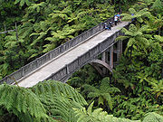
Bridge to Nowhere (New Zealand)
Encyclopedia
Bridge
A bridge is a structure built to span physical obstacles such as a body of water, valley, or road, for the purpose of providing passage over the obstacle...
spanning the Mangapurua Stream in Whanganui National Park
Whanganui National Park
The Whanganui National Park is a national park located in the North Island of New Zealand. Established in 1986, it covers an area of 742 km² bordering the Whanganui River. It incorporates areas of Crown land, former state forest and a number of former reserves. The river itself is not part of the...
, North Island
North Island
The North Island is one of the two main islands of New Zealand, separated from the much less populous South Island by Cook Strait. The island is in area, making it the world's 14th-largest island...
, New Zealand
New Zealand
New Zealand is an island country in the south-western Pacific Ocean comprising two main landmasses and numerous smaller islands. The country is situated some east of Australia across the Tasman Sea, and roughly south of the Pacific island nations of New Caledonia, Fiji, and Tonga...
. It has no roads leading to it, but it is a popular tourist attraction, accessible by boat or kayak, followed by a 45 minute (one way) walk along maintained bush trails.
It was built across the deep Mangapurua Gorge to provide access to an area where the government was opening up land in 1917 for pioneering farmers, mainly soldiers who had returned from World War I
World War I
World War I , which was predominantly called the World War or the Great War from its occurrence until 1939, and the First World War or World War I thereafter, was a major war centred in Europe that began on 28 July 1914 and lasted until 11 November 1918...
. The intention was to build roads to it later, but the area proved to be so remote and unsuitable for farming that the venture failed and the farms reverted to native bush.
A sign on the bridge states:
- Started in January 1935 and completed in June 1936, this bridge was built by the RaetihiRaetihiRaetihi is a town in the central North Island of New Zealand. It is located at the junction of State Highways 4 and 49, 11 kilometres west of Ohakune. The 2006 New Zealand Census of Population and Dwellings recorded its population as 1,035. This constitutes a decrease of 3.4% or 36 people since...
firm of Sandford and Brown, for the Public Works DepartmentNew Zealand Ministry of WorksThe New Zealand Ministry of Works, formerly the Department of Public Works and sometimes referred to as the Public Works Department or PWD, was founded in 1876 and disestablished and privatised in 1988...
. It is 130 feet long, and 125 feet above the stream. The cost of labour was 598 poundsCurrencyIn economics, currency refers to a generally accepted medium of exchange. These are usually the coins and banknotes of a particular government, which comprise the physical aspects of a nation's money supply...
11 shillingShillingThe shilling is a unit of currency used in some current and former British Commonwealth countries. The word shilling comes from scilling, an accounting term that dates back to Anglo-Saxon times where it was deemed to be the value of a cow in Kent or a sheep elsewhere. The word is thought to derive...
s 7 pence, and cartage of all materials (via the Mangapurua Valley road) cost 419 pounds 14 shillings. Unfortunately the cost of materials was not recorded. Aggregate for the concrete is said to have been transported from the Rangitikei RiverRangitikei RiverThe Rangitikei River is one of New Zealand's longest rivers, 185 kilometers long.Its headwaters are to the southeast of Lake Taupo in the Kaimanawa Ranges. It flows from the Central Plateau south past Taihape, Mangaweka, Hunterville, Marton, and Bulls, to the South Taranaki Bight at Tangimoana, 40...
. The completion of the bridge was delayed considerably due to floods, slips, and the consequent delay in the supply of materials. The bridge was built to facilitate vehicular access to the Wanganui RiverWhanganui RiverThe Whanganui River is a major river in the North Island of New Zealand.Known for many years as the Wanganui River, the river's name reverted to Whanganui in 1991, according with the wishes of local iwi. Part of the reason was also to avoid confusion with the Wanganui River in the South Island...
, to link the settlers of the valley with the riverboat service. In 1917 the Government opened up the valley for settlement by soldiers returning from World War IWorld War IWorld War I , which was predominantly called the World War or the Great War from its occurrence until 1939, and the First World War or World War I thereafter, was a major war centred in Europe that began on 28 July 1914 and lasted until 11 November 1918...
. Virgin forest was cleared, and a total of 35 holdings developed. A school was opened, and for some years the valley prospered. However economic hardship, and problems associated with the remoteness and difficulty of access, resulted in many families abandoning their farms. By 1942 there were only 3 families left. After a major flood in January 1942 the Government declined to make further funds available for road maintenance, and it officially closed the valley in May 1942. The disappearing road line, old fence lines, stands of exotic trees, occasional brick chimneys, and this bridge serve as reminders of the ill fated settlement of the Mangapurua valley.
See also
- Bridges in New ZealandBridges in New ZealandThe bridges in New Zealand are many and varied but only date back to the beginning of European settlement in the mid 19th century.-Road bridges:Some of the longest bridges on the state highway network are:* Rakaia River bridge - 1,757 metres...
- Mangapurua Valley Historic Area
External links
- Department of Conservation - Mangapurua/Kaiwhakauka valleys (access information)