

Brazos Mountains
Encyclopedia
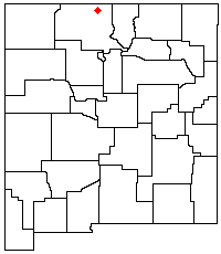
The Brazos Mountains is a range in far northern Rio Arriba County
Rio Arriba County, New Mexico
-2010:Whereas according to the 2010 U.S. Census Bureau:*51.6% White*0.5% Black*16.0% Native American*0.4% Asian*0.0% Native Hawaiian or Pacific Islander*3.3% Two or more races*28.2% Other races*71.3% Hispanic or Latino -2000:...
, in northern New Mexico
New Mexico
New Mexico is a state located in the southwest and western regions of the United States. New Mexico is also usually considered one of the Mountain States. With a population density of 16 per square mile, New Mexico is the sixth-most sparsely inhabited U.S...
in the southwestern United States
United States
The United States of America is a federal constitutional republic comprising fifty states and a federal district...
. A high crest runs from the border with Colorado
Colorado
Colorado is a U.S. state that encompasses much of the Rocky Mountains as well as the northeastern portion of the Colorado Plateau and the western edge of the Great Plains...
for over 20 miles (32 km) in a south-southeasterly direction. The high point of the range at 11405 feet (3,476 m) is on Grouse Mesa,
at the Brazos Benchmark.
Two miles (3 km) to the southeast is the more distinctive Brazos Peak, at 11,288 feet (3440 m).
The range is mostly located in the privately-held Tierra Amarilla Land Grant (the Carson National Forest
Carson National Forest
Carson National Forest is a national forest in northern New Mexico, United States. It encompasses 6,070 square kilometers and is administered by the United States Forest Service...
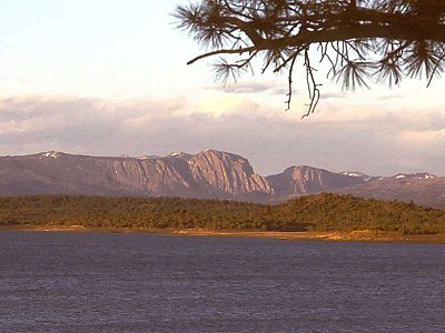
is to the east and south). It is a distinctive part of the view from the west, including from Heron Lake
Heron Lake (New Mexico)
Heron Lake is a reservoir in Rio Arriba County, in northern New Mexico in the southwestern United States. The lake is part of the San Juan-Chama Diversion Project, which transfers water from the upper reaches of the San Juan River through the Azotea Tunnel , into Willow Creek and the Rio Chama...
. U.S. Route 64
U.S. Route 64
U.S. Route 64 is an east–west United States highway that runs for 2,326 miles from eastern North Carolina to just southwest of the Four Corners in northeast Arizona. The western terminus is at U.S. Route 160 in Teec Nos Pos, Arizona. The highway's eastern terminus is at NC 12 and U.S. Route...
crosses the southern end of the range at a 10,481 foot (3194 m) pass. Nearby are the photogenic Brazos Cliffs, headwaters of the Brazos River and part of the Rio Chama river system.
Geolology
The Brazos Mountains are the southwestern remnants of a Laramide peneplainPeneplain
A peneplain is a low-relief plain representing the final stage of fluvial erosion during times of extended tectonic stability. The existence of peneplains, and peneplanation as a geomorphological process, is not without controversy, due to a lack of contemporary examples and uncertainty in...
resulting from the erosion of mountains formed 80 to 55 million years ago during the Laramide orogeny
Laramide orogeny
The Laramide orogeny was a period of mountain building in western North America, which started in the Late Cretaceous, 70 to 80 million years ago, and ended 35 to 55 million years ago. The exact duration and ages of beginning and end of the orogeny are in dispute, as is the cause. The Laramide...
. To the east and northeast lie the Sangre de Cristo Mountains
Sangre de Cristo Mountains
The Sangre de Cristo Mountains are the southernmost subrange of the Rocky Mountains. They are located in southern Colorado and northern New Mexico in the United States...
which share a similar geological history.