
Carson National Forest
Encyclopedia
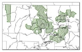
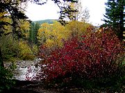
Carson National Forest is a national forest
in northern New Mexico
, United States
. It encompasses 6,070 square kilometers (1.5 million acres) and is administered by the United States Forest Service
. The Forest Service's "mixed use" policy allows for its use for recreation, grazing, and resource extraction.
The forest was once inhabited by the Ancestral Pueblo (Anasazi) people, who left ruins of adobe
dwellings and other artifacts at an archaeological site now called Pot Creek Cultural Site. Some areas of the forest were formerly lands
granted to settlers by the Spanish monarchy
and the Mexican government. After the Mexican-American War, the national forest was established, and was named for American pioneer
Kit Carson
. In 1967, the Alianza Federal de Mercedes
, an organization dedicated to the restoration of Spanish and Mexican land grants, occupied Echo Amphitheater, an area of the forest in an attempt to recreate a historic land grant community. The occupants were evicted for overstaying camping permits. In 1982, the forest grew by 405 square kilometers (100,000 acres) when the Pennzoil
corporation donated the Valle Vidal
Unit to the American people.
Wheeler Peak
, the highest mountain
in New Mexico at 13161 feet (4,011 m), is located in the National Forest.
Within the Carson National Forest are four designated and one proposed wilderness areas, comprising 86193 acres (348.8 km²).
The forest is located mainly in Rio Arriba
(63.4% of acreage) and Taos
(34.65%) counties, but smaller areas extend eastward into western Mora
and Colfax
counties. Forest headquarters are located in Taos, New Mexico
. There are local ranger
district offices in Bloomfield
, Canjilon, El Rito
, Penasco
, Questa
, and Tres Piedras.
Carson National Forest was established with the merger of Taos National Forest
and part of Jemez National Forest
on July 1, 1908.
United States National Forest
National Forest is a classification of federal lands in the United States.National Forests are largely forest and woodland areas owned by the federal government and managed by the United States Forest Service, part of the United States Department of Agriculture. Land management of these areas...
in northern New Mexico
New Mexico
New Mexico is a state located in the southwest and western regions of the United States. New Mexico is also usually considered one of the Mountain States. With a population density of 16 per square mile, New Mexico is the sixth-most sparsely inhabited U.S...
, United States
United States
The United States of America is a federal constitutional republic comprising fifty states and a federal district...
. It encompasses 6,070 square kilometers (1.5 million acres) and is administered by the United States Forest Service
United States Forest Service
The United States Forest Service is an agency of the United States Department of Agriculture that administers the nation's 155 national forests and 20 national grasslands, which encompass...
. The Forest Service's "mixed use" policy allows for its use for recreation, grazing, and resource extraction.
The forest was once inhabited by the Ancestral Pueblo (Anasazi) people, who left ruins of adobe
Adobe
Adobe is a natural building material made from sand, clay, water, and some kind of fibrous or organic material , which the builders shape into bricks using frames and dry in the sun. Adobe buildings are similar to cob and mudbrick buildings. Adobe structures are extremely durable, and account for...
dwellings and other artifacts at an archaeological site now called Pot Creek Cultural Site. Some areas of the forest were formerly lands
Land grant
A land grant is a gift of real estate – land or its privileges – made by a government or other authority as a reward for services to an individual, especially in return for military service...
granted to settlers by the Spanish monarchy
Spanish monarchy
The Monarchy of Spain, constitutionally referred to as The Crown and commonly referred to as the Spanish monarchy or Hispanic Monarchy, is a constitutional institution and an historic office of Spain...
and the Mexican government. After the Mexican-American War, the national forest was established, and was named for American pioneer
Settler
A settler is a person who has migrated to an area and established permanent residence there, often to colonize the area. Settlers are generally people who take up residence on land and cultivate it, as opposed to nomads...
Kit Carson
Kit Carson
Christopher Houston "Kit" Carson was an American frontiersman and Indian fighter. Carson left home in rural present-day Missouri at age 16 and became a Mountain man and trapper in the West. Carson explored the west to California, and north through the Rocky Mountains. He lived among and married...
. In 1967, the Alianza Federal de Mercedes
Alianza Federal de Mercedes
Alianza Federal de Mercedes, which in English translates to Federal Land Grant Alliance, was a group led by Reies Tijerina based in New Mexico in the 1960s that fought for the land rights of Chicano New Mexicans....
, an organization dedicated to the restoration of Spanish and Mexican land grants, occupied Echo Amphitheater, an area of the forest in an attempt to recreate a historic land grant community. The occupants were evicted for overstaying camping permits. In 1982, the forest grew by 405 square kilometers (100,000 acres) when the Pennzoil
Pennzoil
Pennzoil is an American oil company founded in Los Angeles, California in 1913. In 1955, it was acquired by Oil City, Pennsylvania company South Penn Oil, a former branch of Standard Oil. In 1963, South Penn Oil merged with Zapata Petroleum; the merged company took the Pennzoil name. During the...
corporation donated the Valle Vidal
Valle Vidal
The Valle Vidal is a 100,000-acre area in the Sangre de Cristo Mountains within the Carson National Forest, northwest of Cimarron, New Mexico. Pennzoil donated the Valle Vidal to the American public in 1982. Valle Vidal hosts a number of species of animals including elk, black bear, turkey,...
Unit to the American people.
Wheeler Peak
Wheeler Peak (New Mexico)
Wheeler Peak is, at 13,161 ft, the highest peak in the U.S. state of New Mexico. It is located northeast of Taos in the northern part of the state, and just 2 miles southeast of the ski slopes of Taos Ski Valley...
, the highest mountain
Mountain
Image:Himalaya_annotated.jpg|thumb|right|The Himalayan mountain range with Mount Everestrect 58 14 160 49 Chomo Lonzorect 200 28 335 52 Makalurect 378 24 566 45 Mount Everestrect 188 581 920 656 Tibetan Plateaurect 250 406 340 427 Rong River...
in New Mexico at 13161 feet (4,011 m), is located in the National Forest.
Within the Carson National Forest are four designated and one proposed wilderness areas, comprising 86193 acres (348.8 km²).
- Wheeler Peak WildernessWheeler Peak WildernessThe Wheeler Peak Wilderness lies in the Carson National Forest of New Mexico. It contains the highest point in the state, Wheeler Peak.-History:...
- Latir Peak WildernessLatir Peak WildernessLatir Peak Wilderness is a wilderness area located within the Carson National Forest in northern New Mexico, USA. Designated in 1980, the Wilderness is composed of dense forest, meadows, and alpine tundra on Latir Mesa in the northern portion...
- Pecos WildernessPecos WildernessThe Pecos Wilderness is a protected wilderness area within the Santa Fe National Forest and Carson National Forest. The Pecos Wilderness is in the Sangre de Cristo Mountains of north central New Mexico, easily accessible from Santa Fe, the state capital. Covering an area of , it is the second...
(part) - Cruces Basin Wilderness
- Columbine-Hondo Wilderness (proposed)
The forest is located mainly in Rio Arriba
Rio Arriba County, New Mexico
-2010:Whereas according to the 2010 U.S. Census Bureau:*51.6% White*0.5% Black*16.0% Native American*0.4% Asian*0.0% Native Hawaiian or Pacific Islander*3.3% Two or more races*28.2% Other races*71.3% Hispanic or Latino -2000:...
(63.4% of acreage) and Taos
Taos County, New Mexico
-2010:Whereas according to the 2010 U.S. Census Bureau:*68.7% White*0.4% Black*6.2% Native American*0.7% Asian*0.0% Native Hawaiian or Pacific Islander*3.9% Two or more races*20.1% Other races*55.8% Hispanic or Latino -2000:...
(34.65%) counties, but smaller areas extend eastward into western Mora
Mora County, New Mexico
-2010:Whereas according to the 2010 U.S. Census Bureau:*70.9% White*0.7% Black*1.3% Native American*0.3% Asian*0.0% Native Hawaiian or Pacific Islander*3.3% Two or more races*23.5% Other races*81.0% Hispanic or Latino -2000:...
and Colfax
Colfax County, New Mexico
-2010:Whereas according to the 2010 U.S. Census Bureau:*83.8% White*0.5% Black*1.5% Native American*0.4% Asian*0.1% Native Hawaiian or Pacific Islander*3.6% Two or more races*10.1% Other races*47.2% Hispanic or Latino -2000:...
counties. Forest headquarters are located in Taos, New Mexico
Taos, New Mexico
Taos is a town in Taos County in the north-central region of New Mexico, incorporated in 1934. As of the 2000 census, its population was 4,700. Other nearby communities include Ranchos de Taos, Cañon, Taos Canyon, Ranchitos, and El Prado. The town is close to Taos Pueblo, the Native American...
. There are local ranger
National Park Ranger
National Park Service Rangers are among the uniformed employees charged with protecting and preserving areas set aside in the National Park System by the United States Congress and/or the President of the United States...
district offices in Bloomfield
Bloomfield, New Mexico
Bloomfield is a city in San Juan County, New Mexico, United States. It is part of the Farmington Metropolitan Statistical Area. The population was 6,420 at the 2000 census.-Geography:Bloomfield is located at ....
, Canjilon, El Rito
El Rito, New Mexico
El Rito, New Mexico can refer to:* El Rito, Cibola County, New Mexico, an unincorporated community in Cibola County, New Mexico* El Rito, Rio Arriba County, New Mexico, an unincorporated community in Rio Arriba County, New Mexico...
, Penasco
Penasco, New Mexico
Penasco is a census-designated place in Taos County, New Mexico, United States. It is on the scenic High Road to Taos. The population is estimated at about 2,320+ .-Geography:Penasco is located at ....
, Questa
Questa, New Mexico
Questa is a village in Taos County, New Mexico, United States. The population was 1,864 at the 2000 census. Located on the Enchanted Circle scenic highway, near the confluence of the Rio Grande and the Red River, Questa is the least tourist-oriented town on the route...
, and Tres Piedras.
Carson National Forest was established with the merger of Taos National Forest
Taos National Forest
Taos National Forest was established as the Taos Forest Reserve by the U.S. Forest Service in New Mexico on November 7, 1906 with . It became a National Forest on March 4, 1907. On July 1, 1908 the entire forest was combined with part of Jemez National Forest to create Carson National Forest and...
and part of Jemez National Forest
Jemez National Forest
Jemez National Forest in New Mexico was established as the Jemez Forest Reserve by the U.S. Forest Service on October 12, 1905 with . It became a National Forest on March 4, 1907. On July 1, 1915 most of the forest was combined with Pecos National Forest to establish Santa Fe National Forest, and...
on July 1, 1908.
External links
- Carson National Forest - US Forest Service