
Bratislava county
Encyclopedia
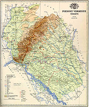
Pozsony county was a historic administrative county
(comitatus
) of the Kingdom of Hungary
. Its territory lies in present-day western Slovakia
.
Its name changed along with that of the city of Pozsony, today's Bratislava
. Its names around 1900 were Pozsony vármegye in Hungarian
, Prešpurská župa
in Slovak
and Preßburger Gespanschaft in German
.
 The county shared borders with the Austria
n land of Lower Austria
and the Hungarian counties Nyitra (Nitra), Komárom
(Komárno), Győr
and Moson
. It was situated between the river Morava in the west, the river Danube
in the south, and the river Váh
in the east. The southern part of the Little Carpathians
divided the county into two. It also covered most of the island known today as Žitný ostrov
between the Danube and the Little Danube
. Its area was 4,370 km² around 1910.
) and Somorja Šamorín
, and from the 18th century onwards the town of Pozsony.
. After Pozsony county's territory had become part of the Kingdom of Hungary
, the Hungarian comitatus
was created around 1000 or even earlier. It was one of the first counties created in the Kingdom Hungary. Its territory comprised roughly both the present-day Bratislava Region
and Trnava Region
. Throughout its history it was among the most prosperous territories of Hungary, and until the late 18th century it was particularly advanced and prosperous. In the 18th and 19th century, the population consisted of Slovaks
(mainly in the north), Hungarians (mainly in the south), Germans
(mainly in Bratislava and larger towns) and Croats
(mainly in the suburbs of Bratislava).
In the aftermath of World War I
, most of Pozsony county became part of newly formed Czechoslovakia, as recognized by the concerned states in the 1920 Treaty of Trianon
. As Bratislava county, it continued to exist until 1927 in Czechoslovakia
, but it had completely different powers and somewhat modified borders. A small part south of the river Danube
remained part of Hungary
and joined Győr-Moson-Pozsony
county.
Following the provisions of the First Vienna Award
, the southeastern part of the area (Žitný ostrov, Senec, Galanta) came under Hungarian administration in November 1938. The approximate Trianon borders were restored after World War II.
County
A county is a jurisdiction of local government in certain modern nations. Historically in mainland Europe, the original French term, comté, and its equivalents in other languages denoted a jurisdiction under the sovereignty of a count A county is a jurisdiction of local government in certain...
(comitatus
Comitatus (Kingdom of Hungary)
A county is the name of a type of administrative units in the Kingdom of Hungary and in Hungary from the 10th century until the present day....
) of the Kingdom of Hungary
Kingdom of Hungary
The Kingdom of Hungary comprised present-day Hungary, Slovakia and Croatia , Transylvania , Carpatho Ruthenia , Vojvodina , Burgenland , and other smaller territories surrounding present-day Hungary's borders...
. Its territory lies in present-day western Slovakia
Slovakia
The Slovak Republic is a landlocked state in Central Europe. It has a population of over five million and an area of about . Slovakia is bordered by the Czech Republic and Austria to the west, Poland to the north, Ukraine to the east and Hungary to the south...
.
Its name changed along with that of the city of Pozsony, today's Bratislava
Bratislava
Bratislava is the capital of Slovakia and, with a population of about 431,000, also the country's largest city. Bratislava is in southwestern Slovakia on both banks of the Danube River. Bordering Austria and Hungary, it is the only national capital that borders two independent countries.Bratislava...
. Its names around 1900 were Pozsony vármegye in Hungarian
Hungarian language
Hungarian is a Uralic language, part of the Ugric group. With some 14 million speakers, it is one of the most widely spoken non-Indo-European languages in Europe....
, Prešpurská župa
Župa
A Župa is a Slavic term, used historically among the Southern and Western branches of the Slavs, originally denoting various territorial and other sub-units, usually a small administrative division, especially a gathering of several villages...
in Slovak
Slovak language
Slovak , is an Indo-European language that belongs to the West Slavic languages .Slovak is the official language of Slovakia, where it is spoken by 5 million people...
and Preßburger Gespanschaft in German
German language
German is a West Germanic language, related to and classified alongside English and Dutch. With an estimated 90 – 98 million native speakers, German is one of the world's major languages and is the most widely-spoken first language in the European Union....
.
Geography
Austria
Austria , officially the Republic of Austria , is a landlocked country of roughly 8.4 million people in Central Europe. It is bordered by the Czech Republic and Germany to the north, Slovakia and Hungary to the east, Slovenia and Italy to the south, and Switzerland and Liechtenstein to the...
n land of Lower Austria
Lower Austria
Lower Austria is the northeasternmost state of the nine states in Austria. The capital of Lower Austria since 1986 is Sankt Pölten, the most recently designated capital town in Austria. The capital of Lower Austria had formerly been Vienna, even though Vienna is not officially part of Lower Austria...
and the Hungarian counties Nyitra (Nitra), Komárom
Komárom county
Komárom county was a historic administrative county of the Kingdom of Hungary in present-day southern Slovakia and north-western Hungary on both sides of the...
(Komárno), Győr
Gyor (county)
Győr county was a historic administrative county of the Kingdom of Hungary in present-day north-western Hungary and south-western Slovakia , mostly on the right side of the Danube river...
and Moson
Moson
Moson was a historic administrative county of the Kingdom of Hungary in present-day eastern Austria and northwestern Hungary, on the right side of the Danube river...
. It was situated between the river Morava in the west, the river Danube
Danube
The Danube is a river in the Central Europe and the Europe's second longest river after the Volga. It is classified as an international waterway....
in the south, and the river Váh
Váh
The Váh is the longest river in entire Slovakia. A left tributary of the Danube river, the Váh is 406 km long, including its Čierny Váh branch...
in the east. The southern part of the Little Carpathians
Little Carpathians
The Little Carpathians are a low, about 100 km long, mountain range, part of the Carpathian Mountains. The mountains are situated in Western Slovakia, covering the area from Bratislava to Nové Mesto nad Váhom, a very small part called Hundsheimer Berge is situated south of Devín Gate in...
divided the county into two. It also covered most of the island known today as Žitný ostrov
Žitný ostrov
Žitný ostrov, also called Veľký Žitný ostrov to differentiate it from Malý Žitný ostrov , is a river island in southwestern Slovakia, extending from Bratislava to Komárno. It lies between the Danube and its tributary Little Danube and is a major part of the Danubian Flat...
between the Danube and the Little Danube
Little Danube
The Little Danube is a branch of the river Danube in Slovakia.It splits from the main river near Bratislava, and flows more or less parallel to the Danube until it flows into the river Váh in Kolárovo...
. Its area was 4,370 km² around 1910.
Seats
The seats of Pozsony county were the Pozsony Castle (Bratislava CastleBratislava Castle
Bratislava Castle is the main castle of Bratislava, the capital of Slovakia.The massive rectangular building with four corner towers stands on a quite isolated rocky hill of the Little Carpathians directly above the Danube river in the middle of Bratislava...
) and Somorja Šamorín
Šamorín
Šamorín or Somorja is a small town in western Slovakia, southeast of Bratislava.-Geography:The town is located on the Danubian Flat at the Žitný ostrov island, near the Gabčíkovo dam on the Danube. It is located around 17 km south-east of Bratislava and 25 km west of Dunajská Streda...
, and from the 18th century onwards the town of Pozsony.
History
A sort of predecessor to Pozsony county existed as early as the 9th century during the time of Great MoraviaGreat Moravia
Great Moravia was a Slavic state that existed in Central Europe and lasted for nearly seventy years in the 9th century whose creators were the ancestors of the Czechs and Slovaks. It was a vassal state of the Germanic Frankish kingdom and paid an annual tribute to it. There is some controversy as...
. After Pozsony county's territory had become part of the Kingdom of Hungary
Kingdom of Hungary
The Kingdom of Hungary comprised present-day Hungary, Slovakia and Croatia , Transylvania , Carpatho Ruthenia , Vojvodina , Burgenland , and other smaller territories surrounding present-day Hungary's borders...
, the Hungarian comitatus
Comitatus (Kingdom of Hungary)
A county is the name of a type of administrative units in the Kingdom of Hungary and in Hungary from the 10th century until the present day....
was created around 1000 or even earlier. It was one of the first counties created in the Kingdom Hungary. Its territory comprised roughly both the present-day Bratislava Region
Bratislava Region
The Bratislava Region is one of the administrative regions of Slovakia. Its capital is Bratislava. It is the smallest of the eight regions of Slovakia.-Geography:...
and Trnava Region
Trnava Region
The Trnava Region is one of the eight Slovak administrative regions.-Geography:It is located in the middlewest part of Slovakia and forms a territorial band between the Bratislava Region and the rest of Slovakia, between Austrian and Czech borders in the north and Hungarian border in the south...
. Throughout its history it was among the most prosperous territories of Hungary, and until the late 18th century it was particularly advanced and prosperous. In the 18th and 19th century, the population consisted of Slovaks
Slovaks
The Slovaks, Slovak people, or Slovakians are a West Slavic people that primarily inhabit Slovakia and speak the Slovak language, which is closely related to the Czech language.Most Slovaks today live within the borders of the independent Slovakia...
(mainly in the north), Hungarians (mainly in the south), Germans
Germans
The Germans are a Germanic ethnic group native to Central Europe. The English term Germans has referred to the German-speaking population of the Holy Roman Empire since the Late Middle Ages....
(mainly in Bratislava and larger towns) and Croats
Croats
Croats are a South Slavic ethnic group mostly living in Croatia, Bosnia and Herzegovina and nearby countries. There are around 4 million Croats living inside Croatia and up to 4.5 million throughout the rest of the world. Responding to political, social and economic pressure, many Croats have...
(mainly in the suburbs of Bratislava).
In the aftermath of World War I
World War I
World War I , which was predominantly called the World War or the Great War from its occurrence until 1939, and the First World War or World War I thereafter, was a major war centred in Europe that began on 28 July 1914 and lasted until 11 November 1918...
, most of Pozsony county became part of newly formed Czechoslovakia, as recognized by the concerned states in the 1920 Treaty of Trianon
Treaty of Trianon
The Treaty of Trianon was the peace agreement signed in 1920, at the end of World War I, between the Allies of World War I and Hungary . The treaty greatly redefined and reduced Hungary's borders. From its borders before World War I, it lost 72% of its territory, which was reduced from to...
. As Bratislava county, it continued to exist until 1927 in Czechoslovakia
Czechoslovakia
Czechoslovakia or Czecho-Slovakia was a sovereign state in Central Europe which existed from October 1918, when it declared its independence from the Austro-Hungarian Empire, until 1992...
, but it had completely different powers and somewhat modified borders. A small part south of the river Danube
Danube
The Danube is a river in the Central Europe and the Europe's second longest river after the Volga. It is classified as an international waterway....
remained part of Hungary
Hungary
Hungary , officially the Republic of Hungary , is a landlocked country in Central Europe. It is situated in the Carpathian Basin and is bordered by Slovakia to the north, Ukraine and Romania to the east, Serbia and Croatia to the south, Slovenia to the southwest and Austria to the west. The...
and joined Győr-Moson-Pozsony
Gyor (county)
Győr county was a historic administrative county of the Kingdom of Hungary in present-day north-western Hungary and south-western Slovakia , mostly on the right side of the Danube river...
county.
Following the provisions of the First Vienna Award
First Vienna Award
The First Vienna Award was the result of the First Vienna Arbitration, which took place at Vienna's Belvedere Palace on November 2, 1938. The Arbitration and Award were direct consequences of the Munich Agreement...
, the southeastern part of the area (Žitný ostrov, Senec, Galanta) came under Hungarian administration in November 1938. The approximate Trianon borders were restored after World War II.
Demographics
Population by language (1910 manipulated census by the ruling Hungarian bureaucracy):- SlovakSlovak languageSlovak , is an Indo-European language that belongs to the West Slavic languages .Slovak is the official language of Slovakia, where it is spoken by 5 million people...
= 166,017 - HungarianHungarian languageHungarian is a Uralic language, part of the Ugric group. With some 14 million speakers, it is one of the most widely spoken non-Indo-European languages in Europe....
= 163,367 - GermanGerman languageGerman is a West Germanic language, related to and classified alongside English and Dutch. With an estimated 90 – 98 million native speakers, German is one of the world's major languages and is the most widely-spoken first language in the European Union....
= 53,822 - CroatianCroatian languageCroatian is the collective name for the standard language and dialects spoken by Croats, principally in Croatia, Bosnia and Herzegovina, the Serbian province of Vojvodina and other neighbouring countries...
= 1,934
Subdivisions
In the early 20th century, the subdivisions of Pozsony/Bratislava county were:| Districts (járás) | |
|---|---|
| District | Capital |
| Dunaszerdahely | Dunaszerdahely |
| Galánta | Galánta |
| Malacka | Malacka |
| Nagyszombat | Nagyszombat |
| Pozsony | Pozsony |
| Somorja | Somorja |
| Szenc | Szenc |
| Urban counties (törvényhatósági jogú város) | |
| Pozsony | |
| Urban districts (rendezett tanácsú város) | |
| Bazin | |
| Modor | |
| Nagyszombat | |
| Szentgyörgy | |