
Boduel
Encyclopedia
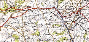
Boduel is a hamlet in east Cornwall
, in the United Kingdom
. It is situated west of Moorswater
, one mile (1.6 km) west of Liskeard
in the civil parish
of Dobwalls and Trewidland
.
It is mentioned in the Domesday Book
as Botiual (Botival), held from Count Mortain. "Hwata holds BODUEL from the Count. He also held it before 1066, and paid tax for half a furlong; 1 furlong of land there, however. Land for one plough; 1/2 a plough there, with 1 slave. 2 villagers and 3 smallholders. Woodland, 10 acres; pasture. 60 acres. Formerly 20 shillings; value now 8 shillings. 5 pigs; 15 sheep; 15 goats."
form of bos, "dwelling-place". "-uel" may come from heuul (sunshine) or hewel (visible, obvious); either of which work because the area is a hill ridge running roughly west-east. "House of Sunshine" seems the most likely interpretation. "Huel" is a variant of "whel", a mine; so it might be thought that it could be "House near a mine" or something similar; but the geology of the area is totally unsuitable for mining - the nearest mining areas are at Caradon
, some miles distant. Current and disused stone quarries are in the area, but "whel" or "huel" were never used for quarries.
Cornwall
Cornwall is a unitary authority and ceremonial county of England, within the United Kingdom. It is bordered to the north and west by the Celtic Sea, to the south by the English Channel, and to the east by the county of Devon, over the River Tamar. Cornwall has a population of , and covers an area of...
, in the United Kingdom
United Kingdom
The United Kingdom of Great Britain and Northern IrelandIn the United Kingdom and Dependencies, other languages have been officially recognised as legitimate autochthonous languages under the European Charter for Regional or Minority Languages...
. It is situated west of Moorswater
Moorswater
Moorswater is an industrial suburb of Liskeard in Cornwall, United Kingdom. It is situated approximately half-a-mile west of Liskeard town centre....
, one mile (1.6 km) west of Liskeard
Liskeard
Liskeard is an ancient stannary and market town and civil parish in south east Cornwall, England, United Kingdom.Liskeard is situated approximately 20 miles west of Plymouth, west of the River Tamar and the border with Devon, and 12 miles east of Bodmin...
in the civil parish
Civil parish
In England, a civil parish is a territorial designation and, where they are found, the lowest tier of local government below districts and counties...
of Dobwalls and Trewidland
Dobwalls and Trewidland
Dobwalls and Trewidland is a civil parish in south-east Cornwall, United Kingdom.The parish is bounded to the north by St Neot and St Cleer parishes, to the east by Liskeard and Menheniot parishes, to the south by Morval parish, to the west by the East Looe River and the parishes of St Pinnock and...
.
History
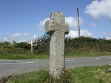
An ancient stone cross stands at the crossroads just west of Boduel. Crosses of this type were apparently way markers between parishes, and may be as early as the 10th century.It is mentioned in the Domesday Book
Domesday Book
Domesday Book , now held at The National Archives, Kew, Richmond upon Thames in South West London, is the record of the great survey of much of England and parts of Wales completed in 1086...
as Botiual (Botival), held from Count Mortain. "Hwata holds BODUEL from the Count. He also held it before 1066, and paid tax for half a furlong; 1 furlong of land there, however. Land for one plough; 1/2 a plough there, with 1 slave. 2 villagers and 3 smallholders. Woodland, 10 acres; pasture. 60 acres. Formerly 20 shillings; value now 8 shillings. 5 pigs; 15 sheep; 15 goats."
Etymology
The meaning of the name is uncertain. "Bod" is almost certainly the old CornishCornish language
Cornish is a Brythonic Celtic language and a recognised minority language of the United Kingdom. Along with Welsh and Breton, it is directly descended from the ancient British language spoken throughout much of Britain before the English language came to dominate...
form of bos, "dwelling-place". "-uel" may come from heuul (sunshine) or hewel (visible, obvious); either of which work because the area is a hill ridge running roughly west-east. "House of Sunshine" seems the most likely interpretation. "Huel" is a variant of "whel", a mine; so it might be thought that it could be "House near a mine" or something similar; but the geology of the area is totally unsuitable for mining - the nearest mining areas are at Caradon
Caradon
Caradon was a local government district in Cornwall, United Kingdom. It contained five towns: Callington, Liskeard, Looe, Saltash and Torpoint, and over 80 villages and hamlets within 41 civil parishes...
, some miles distant. Current and disused stone quarries are in the area, but "whel" or "huel" were never used for quarries.