

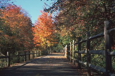
Blackstone River Bikeway
Encyclopedia
Rail trail
A rail trail is the conversion of a disused railway easement into a multi-use path, typically for walking, cycling and sometimes horse riding. The characteristics of former tracks—flat, long, frequently running through historical areas—are appealing for various development. The term sometimes also...
defining the course of the East Coast Greenway
East Coast Greenway
The East Coast Greenway, or ECG, is a project to create a nearly urban path linking the major cities of the Atlantic coast of the United States, from Calais, Maine, to Key West, Florida, for non-motorized human transportation...
through the Blackstone Valley
Blackstone Valley
The Blackstone Valley or Blackstone River Valley is a region of Massachusetts and Rhode Island. It was a major contributor to the American Industrial Revolution...
from Worcester, Massachusetts
Worcester, Massachusetts
Worcester is a city and the county seat of Worcester County, Massachusetts, United States. Named after Worcester, England, as of the 2010 Census the city's population is 181,045, making it the second largest city in New England after Boston....
to Providence, Rhode Island
Providence, Rhode Island
Providence is the capital and most populous city of Rhode Island and was one of the first cities established in the United States. Located in Providence County, it is the third largest city in the New England region...
.
Approximately 10 miles (16.1 km) of the trail has been completed in Rhode Island
Rhode Island
The state of Rhode Island and Providence Plantations, more commonly referred to as Rhode Island , is a state in the New England region of the United States. It is the smallest U.S. state by area...
, connecting the communities of Woonsocket
Woonsocket, Rhode Island
Woonsocket is a city in Providence County, Rhode Island, United States. The population was 41,186 at the 2010 census, making it the sixth largest city in the state. Woonsocket lies directly south of the Massachusetts border....
, Lincoln
Lincoln, Rhode Island
Lincoln is a town in Providence County, Rhode Island, United States. The population was 21,105 at the 2010 census. Lincoln is located in northeastern Rhode Island, north of Providence....
, Cumberland
Cumberland, Rhode Island
Cumberland is a town in Providence County, Rhode Island, United States, incorporated in 1746. The population was 33,506 at the 2010 census.-History:...
and Manville
Manville, Rhode Island
Manville is a village in the town of Lincoln in Providence County, Rhode Island, United States. It is located at latitude 41.9616° North, longitude 71.4744° West. It has been assigned the ZIP Code 02838....
. 2.5 miles (4 km) of completed trail in Massachusetts
Massachusetts
The Commonwealth of Massachusetts is a state in the New England region of the northeastern United States of America. It is bordered by Rhode Island and Connecticut to the south, New York to the west, and Vermont and New Hampshire to the north; at its east lies the Atlantic Ocean. As of the 2010...
connect Worcester and Millbury
Millbury, Massachusetts
Millbury is a town in Worcester County, Massachusetts, United States. The population was 13,261 at the 2010 census. The town is part of the Blackstone River Valley National Heritage Corridor.-History:...
.
The path follows follows the right-of-way
Right-of-way (railroad)
A right-of-way is a strip of land that is granted, through an easement or other mechanism, for transportation purposes, such as for a trail, driveway, rail line or highway. A right-of-way is reserved for the purposes of maintenance or expansion of existing services with the right-of-way...
of the old Providence and Worcester Railroad
Providence and Worcester Railroad
The Providence and Worcester Railroad is a Class II railroad in the United States. The railroad connects from Gardner in central Massachusetts, south through its namesake cities of Worcester and Providence, Rhode Island, and west from Rhode Island through Connecticut and into New York City...
and its predecessor, the Blackstone Canal
Blackstone Canal
The Blackstone Canal was a waterway linking Worcester, Massachusetts, to Providence, Rhode Island through the Blackstone Valley via a series of locks and canals during the early 19th century.-History:...
, running alongside the Blackstone River
Blackstone River
The Blackstone River is a river in the U.S. states of Massachusetts and Rhode Island. It flows approximately 48 mi and drains a watershed of approximately 540 sq. mi...
. Once constructed, the bikeway will be linked to the East Bay Bike Path
East Bay Bike Path
right|thumb|400px|The East Bay Bike Path in July 2009, facing south near the southern terminus of the bike path in Bristol.The East Bay Bike Path is a paved rail trail in Rhode Island....
, for an additional 14.5 miles (23.3 km) of trail to Bristol, Rhode Island
Bristol, Rhode Island
Bristol is a town in and the historic county seat of Bristol County, Rhode Island, United States. The population was 22,954 at the 2010 census. Bristol, a deepwater seaport, is named after Bristol, England....
. The Blackstone River Bikeway is also a designated section of the East Coast Greenway
East Coast Greenway
The East Coast Greenway, or ECG, is a project to create a nearly urban path linking the major cities of the Atlantic coast of the United States, from Calais, Maine, to Key West, Florida, for non-motorized human transportation...
, the 2900-mile trail system connecting cities from Maine to Florida.
History
In 1985, the Blackstone River Valley National Heritage Corridor (known after 1999 as the John H. Chafee Blackstone River Valley National Heritage Corridor) was designated by the United States CongressUnited States Congress
The United States Congress is the bicameral legislature of the federal government of the United States, consisting of the Senate and the House of Representatives. The Congress meets in the United States Capitol in Washington, D.C....
, following the path of the Blackstone River from Providence to Worcester.
Rhode Island
In 1997, the Rhode Island Department of Environmental Management and Department of TransportationRhode Island Department of Transportation
The Rhode Island Department of Transportation is a Rhode Island state government agency charged with construction, maintenance and inspection of a wide range of transportation infrastructure. These include 1,102 miles of state roads and highways, 772 bridges, and 777 traffic signals...
began work on the first Rhode Island segment, from Lincoln to Ashton. http://www.dem.ri.gov/news/1997/pr/0905971.htm This segment was completed in 1998. A second Rhode Island segment was completed in 2002, from Ashton to Manville. http://www.dem.ri.gov/news/2002/pr/0606021.htm In August 2007, a bridge reconstruction project at Martin Street was completed, ending a three-year bike path closure. The new bridge also incorporated a major safety improvement for the path with the path passing underneath Martin Street instead of meeting it at grade. In November 2007, a 2 miles (3.2 km) extension from Manville to the Woonsocket Water Treatment Plant was opened. A 1 miles (1.6 km) segment from Lonsdale to Valley Falls, which includes more than 500 feet (152.4 m) of boardwalk over part of the Lonsdale Marsh, opened in 2008. A segment through the River's Edge Recreational Complex in Woonsocket was completed in 2008, and that segment was linked to the previously-completed portions to the south later that year. The path is about 10 miles (16.1 km) long as of mid-2009. Additional segments are under design to extend the path further through Woonsocket toward the Massachusetts border and south into Central Falls and Pawtucket. In 2011, an 8.5 mile segment of on-road bicycle lanes opened connecting the blackstone river bikeway with the east bay bike path, starting in providence.
Massachusetts
In 1996, a study undertaken by the Massachusetts Highway DepartmentMassachusetts Highway Department
The Massachusetts Highway Department was the former name of the highway department in the United States Commonwealth of Massachusetts from 1991 until it became the highway division of the Massachusetts Department of Transportation on November 1, 2009...
(MHD) and the Massachusetts Department of Conservation and Recreation (known at the time as the Department of Environmental Management) produced a plan for seven segments of trail linking Worcester with Blackstone, Massachusetts
Blackstone, Massachusetts
Blackstone is a town in Worcester County, Massachusetts, United States. The population was 9,026 at the 2010 census. It is formally a part of the Providence metropolitan area. Blackstone is the only municipality in Massachusetts to employ automatic cameras in traffic enforcement.- History :This...
and the Rhode Island border.
- Blackstone to MillvilleMillville, MassachusettsMillville is a town in Worcester County, Massachusetts, United States. The population was 3,190 at the 2010 census. It is part of the Providence metropolitan area.- History :...
(2.92 miles) - Millville to UxbridgeUxbridge, MassachusettsUxbridge is a town in Worcester County, Massachusetts, in the United States. It was first settled in 1662, incorporated in 1727 at Suffolk County, and named for the Earl of Uxbridge. Uxbridge is south-southeast of Worcester, north-northwest of Providence, and southwest of Boston. It is part of...
(3.30 miles) - Uxbridge to NorthbridgeNorthbridge, MassachusettsNorthbridge is a town in Worcester County, Massachusetts, United States. The population was 15,707 at the 2010 census. The Northbridge Town Hall is located at 7 Main Street in Whitinsville. The town is now a part of the Blackstone River Valley National Heritage Corridor, of the National Park...
(9.09 miles) - Northbridge to GraftonGrafton, MassachusettsGrafton is a town in Worcester County, Massachusetts, United States. The population was 17,765 at the 2010 census. Grafton is the home of a Nipmuc village known as Hassanamisco Reservation, the Willard House and Clock Museum, and the Tufts University Cummings School of Veterinary Medicine...
(1.39 miles) - Grafton to Millbury via SuttonSutton, Massachusetts-Library:The Sutton Free Library was established in 1876. In fiscal year 2008, the town of Sutton spent 0.7% of its budget on its public library—some $18 per person.-Education:...
(6.02 miles) - Millbury to Worcester (4+ miles)
- Worcester (2.61 miles)
Construction was delayed due to a lack of state funds, a shortfall attributed to the over-budget "Big Dig" highway tunnel project in Boston. http://www.ltolman.org/99arch/516blackstone.htm In 2005, the first 2.5 miles (4 km) segment, from Worcester to Millbury, was opened to the public.
See also
- East Bay Bike PathEast Bay Bike Pathright|thumb|400px|The East Bay Bike Path in July 2009, facing south near the southern terminus of the bike path in Bristol.The East Bay Bike Path is a paved rail trail in Rhode Island....
- Washington Secondary Rail TrailWashington Secondary Rail Trailright|thumb|400px|The Washington Secondary Bike path includes several bridges.The Washington Secondary Rail Trail is a rail trail located in Rhode Island....
- Greenways Alliance of Rhode IslandGreenways Alliance of Rhode IslandThe was a non-profit organization dedicated to advocacy for Rhode Island's bike paths, trails and greenspaces. It also served as the state committee of the East Coast Greenway...