

Bethlehem, New York
Encyclopedia
Bethlehem is a town in Albany County
, New York
, USA
. The population was 33,656 at the 2010 census. The town is south of Albany
. Bethlehem includes the following hamlets: Delmar
, Elsmere
, Slingerlands, Glenmont
, Selkirk
, South
and North Bethlehem. U.S. Route 9W
passes through the town. The town is named after the biblical Bethlehem
.
sailed up the river that would eventually bear his name, he is thought to have landed at what is now the town of Bethlehem. The spot where he is presumed to have landed is commemorated at the town's Henry Hudson Park. The town was established on March 12, 1793 from the town of Watervliet
. In 1832, part of the town was used to form the town of New Scotland
.
The town's earliest growth took place in Normansville
named for its location along the Normans Kill
, a creek, which forms the town's border with Albany. Normansville still exists today, though it is unnoticed by most living in Bethlehem since it is accessible only by one downhill road (which has no outlet). In the mid-19th century the Delaware and Hudson railroad initiated service into the hamlet then called Adamsville, renaming the hamlet Delmar. Delmar has become the most populous hamlet and its Delaware Avenue is the site of the present day town hall, police station, justice court, and public library, as well as numerous businesses. The railroad discontinued passenger service in the 1960s and its tracks started being removed in the year 2000 with the last of the track removed in 2005. The town has continued to grow, and is today considered to be an affluent suburb of the city of Albany.
includes grades 9–12.
The town also includes the School of Saint Thomas the Apostle, a Catholic school for grades K–8 located across from the Catholic Church. Bethlehem Children's School is an independent school in the district for students in K–8, offering a creative, child centered environmental education approach to learning.
The school district offers Continuing Education classes in a variety of topics for adult learners of all ages. The school district also provides busing and most textbooks for families who choose to educate their children in private schools.
Residents in the hamlets of Selkirk and South Bethlehem are part of the Ravena-Coeymans-Selkirk Central School District
. Residents in the hamlet of North Bethlehem are part of the Guilderland Central School District. One of the two elementary schools of the district, Albertus W. Becker Elementary School, is in Selkirk.
 According to the United States Census Bureau
, the town has a total area of 49.6 square miles (128.5 km²), of which, 48.8 square miles (126.4 km²) of it is land and 0.8 square miles (2.1 km²) of it (1.55%) is water.
, is the border of Rensselaer County
. To the north, the town shares a border with Albany, and the town of Guilderland
. To the west is the town of New Scotland
, and to the south is the town of Coeymans.
The New York State Thruway
(Interstate 87
) passes through the town. The town is also served by the CDTA
number 13 (New Scotland Avenue), 18 (Delaware Avenue), and 19 (Voorheesville) busses.
of 2000, there were 31,304 people, 12,112 households, and 8,551 families residing in the town. The population density
was 641.3 people per square mile (247.6/km²). There were 12,459 housing units at an average density of 255.2 per square mile (98.6/km²). The racial makeup of the town was 94.74% White, 2.26% African American, 0.15% Native American, 1.66% Asian, 0.04% Pacific Islander, 0.31% from other races
, and 0.84% from two or more races. Hispanic or Latino of any race were 1.74% of the population.
There were 12,112 households out of which 36.6% had children under the age of 18 living with them, 60.0% were married couples
living together, 8.0% had a female householder with no husband present, and 29.4% were non-families. 25.0% of all households were made up of individuals and 11.7% had someone living alone who was 65 years of age or older. The average household size was 2.53 and the average family size was 3.06.
In the town the population was spread out with 27.5% under the age of 18, 5.2% from 18 to 24, 27.1% from 25 to 44, 25.8% from 45 to 64, and 14.4% who were 65 years of age or older. The median age was 40 years. For every 100 females there were 90.9 males. For every 100 females age 18 and over, there were 85.5 males.
The median income for a household in the town was $63,169, and the median income for a family was $77,211. Males had a median income of $52,433 versus $36,739 for females. The per capita income
for the town was $31,492. About 2.3% of families and 3.1% of the population were below the poverty line, including 3.6% of those under age 18 and 2.8% of those age 65 or over.
Albany County, New York
Albany County is a county located in the U.S. state of New York, and is part of the Albany-Schenectady-Troy Metropolitan Statistical Area. The name is from the title of the Duke of York and Albany, who became James II of England . As of the 2010 census, the population was 304,204...
, New York
New York
New York is a state in the Northeastern region of the United States. It is the nation's third most populous state. New York is bordered by New Jersey and Pennsylvania to the south, and by Connecticut, Massachusetts and Vermont to the east...
, USA
United States
The United States of America is a federal constitutional republic comprising fifty states and a federal district...
. The population was 33,656 at the 2010 census. The town is south of Albany
Albany, New York
Albany is the capital city of the U.S. state of New York, the seat of Albany County, and the central city of New York's Capital District. Roughly north of New York City, Albany sits on the west bank of the Hudson River, about south of its confluence with the Mohawk River...
. Bethlehem includes the following hamlets: Delmar
Delmar, New York
Delmar is a hamlet in the town of Bethlehem, Albany County, New York. A census-designated place has been established since 1980 by the US Bureau of Census for tabulating the population of what the census has defined as the boundaries of the urbanized area in and around Delmar. The population was...
, Elsmere
Elsmere, New York
Elsmere is a hamlet of the town of the Bethlehem in Albany County, New York. The hamlet is a suburb of the neighboring city of Albany. From the northeast to the southwest it is bisected by New York Route 443 which is also the main street and a major commuter route into Albany...
, Slingerlands, Glenmont
Glenmont, New York
Glenmont is a hamlet in the town of Bethlehem, Albany County, New York. Glenmont is in the northeastern corner of the town and is a suburb of the neighboring city of Albany...
, Selkirk
Selkirk, New York
Selkirk is a hamlet in the town of Bethlehem, Albany County, New York. It is located south of the city of Albany, it is an suburb of that city....
, South
South Bethlehem, New York
South Bethlehem is a hamlet in the town of Bethlehem, Albany County, New York. The hamlet sits on New York State Route 396 and lies southwest of the Selkirk Rail Yard and just north of the Coeymans town line.-History:...
and North Bethlehem. U.S. Route 9W
U.S. Route 9W
U.S. Route 9W is a north–south U.S. Highway in the states of New Jersey and New York. It begins on Fletcher Avenue in Fort Lee, New Jersey as it crosses the US 1 & 9, US 46, and the Interstate 95 approaches to the George Washington Bridge, where it heads north up the west...
passes through the town. The town is named after the biblical Bethlehem
Bethlehem
Bethlehem is a Palestinian city in the central West Bank of the Jordan River, near Israel and approximately south of Jerusalem, with a population of about 30,000 people. It is the capital of the Bethlehem Governorate of the Palestinian National Authority and a hub of Palestinian culture and tourism...
.
History
When Henry HudsonHenry Hudson
Henry Hudson was an English sea explorer and navigator in the early 17th century. Hudson made two attempts on behalf of English merchants to find a prospective Northeast Passage to Cathay via a route above the Arctic Circle...
sailed up the river that would eventually bear his name, he is thought to have landed at what is now the town of Bethlehem. The spot where he is presumed to have landed is commemorated at the town's Henry Hudson Park. The town was established on March 12, 1793 from the town of Watervliet
Watervliet (town), New York
For the Shaker village, see Watervliet Shaker Historic District.The town of Watervliet was a town that at its height encompassed most of present-day Albany County and the majority of the current town of Niskayuna in neighboring Schenectady County, in the state of New York, United States...
. In 1832, part of the town was used to form the town of New Scotland
New Scotland, New York
New Scotland is a town in Albany County, New York, United States. The population was 8,648 at the 2010 census.The town is southwest of Albany, New York, the state capital. New Scotland is centrally located in the county.-History:...
.
The town's earliest growth took place in Normansville
Normansville, New York
Normansville is a hamlet in the town of Bethlehem and a neighborhood in the city of Albany, Albany County, New York. The entire area was one hamlet in Bethlehem until the portion north of the Normans Kill was annexed by Albany in 1916...
named for its location along the Normans Kill
Normans Kill
The Normans Kill is a creek in New York's Capital District located in Schenectady and Albany counties, which flows southeasterly from its source in the town of Duanesburg near Delanson to its mouth at the Hudson River in the town of Bethlehem. The stream creates the Watervliet Reservoir in the...
, a creek, which forms the town's border with Albany. Normansville still exists today, though it is unnoticed by most living in Bethlehem since it is accessible only by one downhill road (which has no outlet). In the mid-19th century the Delaware and Hudson railroad initiated service into the hamlet then called Adamsville, renaming the hamlet Delmar. Delmar has become the most populous hamlet and its Delaware Avenue is the site of the present day town hall, police station, justice court, and public library, as well as numerous businesses. The railroad discontinued passenger service in the 1960s and its tracks started being removed in the year 2000 with the last of the track removed in 2005. The town has continued to grow, and is today considered to be an affluent suburb of the city of Albany.
Local landmarks
The town includes several historic buildings and landmarks.- Four Corners: This Delmar intersection of Delaware Avenue and Kenwood Avenue has served as the town's traditional center and is presently the location of several stores, banks, restaurants and the post office. It is also within walking distance to most Delmar residents.
- Adams House: In 1838 Nathaniel Adams built a hotel on Delaware Avenue. This stately building later served as the Town Hall. In 1980, the Town Hall moved to a larger location and the volunteer fire department took over the building.
- Beckers Homestead: Albertus Becker built this house in 1800. His grandson, Albertus Becker II, would become Town Supervisor in 1863.
- Bethlehem HouseBethlehem HouseBethlehem House, also known as the Rensselaer Nicoll House, is a historic home located at Bethlehem in Albany County, New York. It was originally built about 1735 and expanded in 1796, 1810 , and 1830 . It is two and one half stories high with two and one story additions in the rear. It is...
: listed on the National Register of Historic PlacesNational Register of Historic PlacesThe National Register of Historic Places is the United States government's official list of districts, sites, buildings, structures, and objects deemed worthy of preservation...
in 1973. - District School No. 1District School No. 1 (Bethlehem, New York)District School No. 1, also known as Cedar Hill Schoolhouse, is a historic school building located at Bethlehem in Albany County, New York. It was built in 1859 and expanded in 1907. It is a one story, rectangular brick building, seven bays by three bays in the Italianate style with later...
: listed on the National Register of Historic Places in 1998. - Memorial Park: A small pocket park along Delaware Avenue created to honor the town's war veterans. The park also provides pedestrian access to the old Delaware & Hudson railway bed.
- Elm Avenue Park: This is the Town's largest park and a very popular summertime gathering point. Includes three outdoor swimming pools, a splash zone for toddlers, playground, basketball and tennis courts. Winter activities include ice skating, hockey, cross country skiing, sledding, and snowmobiling. Admission to the pool area restricted to Town residents and their guests under a fee based system.http://wwww.townofbethlehen.org/parks.html
- Bethlehem Central Middle School: This school was first used (and is still labeled as) the Senior High School and was built in the Federalist style. Over the years it has had several additions, and now includes outdoor tennis courts, basketball courts, softball fields, running track, cross country trails, and soccer fields. These facilities are open to the public when the school is not in session.
- Delaware Plaza: A shopping plaza built in the 1950s, located on Delaware Avenue in Elsmere. Delaware Plaza is home to a large supermarket (currently a HannafordHannafordHannaford may refer to more than one thing.* Hannaford, North Dakota, a town in North Dakota* Hannaford Bros. Co., a supermarket chain* Samuel Hannaford & Sons, a Cincinnati-based architectural firm founded by Samuel Hannaford...
) as well as some 30 other shops and restaurants. - Delmar post officeU.S. Post Office (Delmar, New York)The U.S. Post Office in Delmar, New York is located on Delaware Avenue in the middle of the hamlet. It serves the 12054 ZIP Code, covering Delmar and its surrounding area. It was added to the National Register of Historic Places in 1988...
: Built during the later years of the DepressionGreat DepressionThe Great Depression was a severe worldwide economic depression in the decade preceding World War II. The timing of the Great Depression varied across nations, but in most countries it started in about 1929 and lasted until the late 1930s or early 1940s...
, it is the only one of the 13 Colonial RevivalColonial Revival architectureThe Colonial Revival was a nationalistic architectural style, garden design, and interior design movement in the United States which sought to revive elements of Georgian architecture, part of a broader Colonial Revival Movement in the arts. In the early 1890s Americans began to value their own...
-styleArchitectural styleArchitectural styles classify architecture in terms of the use of form, techniques, materials, time period, region and other stylistic influences. It overlaps with, and emerges from the study of the evolution and history of architecture...
New York post offices designed by Louis Simon that had no cupolaCupolaIn architecture, a cupola is a small, most-often dome-like, structure on top of a building. Often used to provide a lookout or to admit light and air, it usually crowns a larger roof or dome....
.
Politics
Town government had been dominated for over 120 years by the Republican party. That changed in 2003 with the election of Democrats Theresa Egan as Town Supervisor and Dan Plummer, along with Independence Party member Tim Gordon, creating a new majority on the Town Board for the first time in recollection. The Democrats further solidified their majority in 2005. On April 11, 2007 Supervisor Egan resigned her position, and the Bethlehem Town Board acting immediately, voted unanimously to appoint John H. (Jack) Cunningham to fill the vacancy. He was sworn in to office on April 12, 2007 and was elected to serve a full term in November 2007.Education
Most town residents live within the Bethlehem Central School District. The town has six public elementary schools – Hamagrael, Elsmere, Slingerlands, Glenmont and Clarksville. The sixth elementary school, Eagle Elementary, was recently built and opened its doors to students in September 2008. Its name was the result of a district-wide student vote. Elementary schools include students up to grade 5. The Bethlehem Central Middle School educates children in grades 6, 7 and 8, while the Bethlehem Central High SchoolBethlehem Central High School
Bethlehem Central High School is a high school in Delmar, New York, just south of Albany. Located at 700 Delaware Avenue, the school serves students in grades 9-12 from the towns of Bethlehem and New Scotland. The school was ranked 1048 on Newsweek's 2010 " Top US High Schools."The high school was...
includes grades 9–12.
The town also includes the School of Saint Thomas the Apostle, a Catholic school for grades K–8 located across from the Catholic Church. Bethlehem Children's School is an independent school in the district for students in K–8, offering a creative, child centered environmental education approach to learning.
The school district offers Continuing Education classes in a variety of topics for adult learners of all ages. The school district also provides busing and most textbooks for families who choose to educate their children in private schools.
Residents in the hamlets of Selkirk and South Bethlehem are part of the Ravena-Coeymans-Selkirk Central School District
Ravena-Coeymans-Selkirk Central Schools
The Ravena-Coeymans-Selkirk Central Schools are located in Albany County, New York. There are four schools in the district: Albertus W. Becker Elementary, Pieter B. Coeymans Elementary, R.C.S. Middle School, and Ravena-Coeymans-Selkirk High School . Albertus W. Becker Elementary is located in...
. Residents in the hamlet of North Bethlehem are part of the Guilderland Central School District. One of the two elementary schools of the district, Albertus W. Becker Elementary School, is in Selkirk.
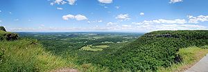
Geography
United States Census Bureau
The United States Census Bureau is the government agency that is responsible for the United States Census. It also gathers other national demographic and economic data...
, the town has a total area of 49.6 square miles (128.5 km²), of which, 48.8 square miles (126.4 km²) of it is land and 0.8 square miles (2.1 km²) of it (1.55%) is water.
Location and adjacent areas
The town is in Albany County, New York. The east town line, defined by the Hudson RiverHudson River
The Hudson is a river that flows from north to south through eastern New York. The highest official source is at Lake Tear of the Clouds, on the slopes of Mount Marcy in the Adirondack Mountains. The river itself officially begins in Henderson Lake in Newcomb, New York...
, is the border of Rensselaer County
Rensselaer County, New York
Rensselaer County is a county in the U.S. state of New York. As of the 2010 census, the population was 159,429. Its name is in honor of the family of Kiliaen van Rensselaer, the original Dutch owner of the land in the area. Its county seat is Troy...
. To the north, the town shares a border with Albany, and the town of Guilderland
Guilderland, New York
Guilderland is a town in Albany County, New York, United States. In the 2010 census, the town had a population of 35,303. The town is named for the Gelderland province in the Netherlands....
. To the west is the town of New Scotland
New Scotland, New York
New Scotland is a town in Albany County, New York, United States. The population was 8,648 at the 2010 census.The town is southwest of Albany, New York, the state capital. New Scotland is centrally located in the county.-History:...
, and to the south is the town of Coeymans.
The New York State Thruway
New York State Thruway
The New York State Thruway is a system of limited-access highways located within the state of New York in the United States. The system, known officially as the Governor Thomas E. Dewey Thruway for former New York Governor Thomas E. Dewey, is operated by the New York State Thruway Authority and...
(Interstate 87
Interstate 87
Interstate 87 is a Interstate Highway located entirely within New York State in the United States of America. I-87 is the longest intrastate Interstate highway in the Interstate Highway System. Its southern end is at the Bronx approaches of the Robert F. Kennedy Bridge in New York City...
) passes through the town. The town is also served by the CDTA
Capital District Transportation Authority
The Capital District Transportation Authority is a public benefit organization that provides transportation in the Capital District of New York State...
number 13 (New Scotland Avenue), 18 (Delaware Avenue), and 19 (Voorheesville) busses.
Demographics
As of the censusCensus
A census is the procedure of systematically acquiring and recording information about the members of a given population. It is a regularly occurring and official count of a particular population. The term is used mostly in connection with national population and housing censuses; other common...
of 2000, there were 31,304 people, 12,112 households, and 8,551 families residing in the town. The population density
Population density
Population density is a measurement of population per unit area or unit volume. It is frequently applied to living organisms, and particularly to humans...
was 641.3 people per square mile (247.6/km²). There were 12,459 housing units at an average density of 255.2 per square mile (98.6/km²). The racial makeup of the town was 94.74% White, 2.26% African American, 0.15% Native American, 1.66% Asian, 0.04% Pacific Islander, 0.31% from other races
Race (United States Census)
Race and ethnicity in the United States Census, as defined by the Federal Office of Management and Budget and the United States Census Bureau, are self-identification data items in which residents choose the race or races with which they most closely identify, and indicate whether or not they are...
, and 0.84% from two or more races. Hispanic or Latino of any race were 1.74% of the population.
There were 12,112 households out of which 36.6% had children under the age of 18 living with them, 60.0% were married couples
Marriage
Marriage is a social union or legal contract between people that creates kinship. It is an institution in which interpersonal relationships, usually intimate and sexual, are acknowledged in a variety of ways, depending on the culture or subculture in which it is found...
living together, 8.0% had a female householder with no husband present, and 29.4% were non-families. 25.0% of all households were made up of individuals and 11.7% had someone living alone who was 65 years of age or older. The average household size was 2.53 and the average family size was 3.06.
In the town the population was spread out with 27.5% under the age of 18, 5.2% from 18 to 24, 27.1% from 25 to 44, 25.8% from 45 to 64, and 14.4% who were 65 years of age or older. The median age was 40 years. For every 100 females there were 90.9 males. For every 100 females age 18 and over, there were 85.5 males.
The median income for a household in the town was $63,169, and the median income for a family was $77,211. Males had a median income of $52,433 versus $36,739 for females. The per capita income
Per capita income
Per capita income or income per person is a measure of mean income within an economic aggregate, such as a country or city. It is calculated by taking a measure of all sources of income in the aggregate and dividing it by the total population...
for the town was $31,492. About 2.3% of families and 3.1% of the population were below the poverty line, including 3.6% of those under age 18 and 2.8% of those age 65 or over.
Communities and locations in Bethlehem
- Beckers Corners: A hamlet in the south part of the town at Route 9WU.S. Route 9WU.S. Route 9W is a north–south U.S. Highway in the states of New Jersey and New York. It begins on Fletcher Avenue in Fort Lee, New Jersey as it crosses the US 1 & 9, US 46, and the Interstate 95 approaches to the George Washington Bridge, where it heads north up the west...
. - Bethlehem Center: A hamlet in the northeast part of the town.
- Bethlehem Heights: A community east of South Bethlehem, and often associated with it.
- Callahans Corners: A location at the southwest corner of the town.
- Cedar Hill: A hamlet in the southeast part of the town, east of the Thruway.
- DelmarDelmar, New YorkDelmar is a hamlet in the town of Bethlehem, Albany County, New York. A census-designated place has been established since 1980 by the US Bureau of Census for tabulating the population of what the census has defined as the boundaries of the urbanized area in and around Delmar. The population was...
: A hamlet near the center of the town and the location of the town government. Formerly known as Adamsville. - ElsmereElsmere, New YorkElsmere is a hamlet of the town of the Bethlehem in Albany County, New York. The hamlet is a suburb of the neighboring city of Albany. From the northeast to the southwest it is bisected by New York Route 443 which is also the main street and a major commuter route into Albany...
: A hamlet east of and adjacent to Delmar. - GlenmontGlenmont, New YorkGlenmont is a hamlet in the town of Bethlehem, Albany County, New York. Glenmont is in the northeastern corner of the town and is a suburb of the neighboring city of Albany...
: A hamlet in the eastern part of the town. - Henry Hudson Park A park east of Cedar Hill at the Hudson River.
- Houcks Corners: A hamlet south of Delmar.
- Mallorys Corners: A location in the south part of the town.
- Meyers Corners: A location in the south part of the town.
- NormansvilleNormansville, New YorkNormansville is a hamlet in the town of Bethlehem and a neighborhood in the city of Albany, Albany County, New York. The entire area was one hamlet in Bethlehem until the portion north of the Normans Kill was annexed by Albany in 1916...
: A hamlet in the north part of the town. - North Bethlehem: A hamlet at the north town line in the northeast part of the town.
- SelkirkSelkirk, New YorkSelkirk is a hamlet in the town of Bethlehem, Albany County, New York. It is located south of the city of Albany, it is an suburb of that city....
: A hamlet east of South Bethlehem. - SlingerlandsSlingerlands, New YorkSlingerlands is a hamlet in the town of Bethlehem, Albany County, New York. It is located immediately west of Delmar and near the New Scotland town-line and south of the Albany city-limits. It is a suburb of Albany...
: A hamlet immediately west of Delmar and near the west town line. - Spawn Hollow: A community in the southwest corner of the town, often associated with South Bethlehem.
- South Albany: A hamlet in the south part of the town, north of South Bethlehem.
- South BethlehemSouth Bethlehem, New YorkSouth Bethlehem is a hamlet in the town of Bethlehem, Albany County, New York. The hamlet sits on New York State Route 396 and lies southwest of the Selkirk Rail Yard and just north of the Coeymans town line.-History:...
: A hamlet in the south part of the town. - Wemple: A hamlet in the southeast part of the town.