

Normansville, New York
Encyclopedia
Normansville is a hamlet in the town of Bethlehem
and a neighborhood in the city of Albany
, Albany County
, New York
. The entire area was one hamlet in Bethlehem until the portion north of the Normans Kill
was annexed by Albany in 1916. The Delaware Turnpike once ran through both neighborhoods until 1929 with the construction of a new much higher, longer, and wider Delaware Avenue Bridge over the Normans Kill. This allowed commuters to and from Albany to bypass both Normansvilles. The original lower bridge still stands, though it has been closed to vehicular traffic since January 1990.
. Upper Hollow had its start with the construction of the Delaware Turnpike in 1805 which went from the city of Albany to Otego (which then was part of Delaware County
). At the Normans Kill (kill is Dutch for stream) the road was carried by a 100 feet (30.5 m) wooden bridge and northwest of this bridge was a toll-gate. This bridge was washed away by a freshet
in 1869. This was the year after the turnpike company had abandoned the road and so the town of Bethlehem built an iron bridge in its place.
Soon after the turnpike was constructed taverns and various industries began to spring up to take advantage of the power that could be harnessed from the Normans Kill's waters. Among the industries were cloth mills and saw mills, several of these mills were swept aside by the same freshet that washed away the bridge, they were quickly rebuilt but by the beginning of the 20th century the mills were abandoned. Another major industry along the Normans Kill was that of cutting ice blocks from the creek during the winter and storing it for shipping to New York City
and other locations for use in iceboxes. The Pappalau Ice House on the Albany side was one of many ice houses along the Normans Kill and Hudson River
at the end of the 1800s, by 1920 it too would be abandoned as new technologies made the industry obsolete.
In 1916 Albany annexed much of the town of Bethlehem up to the Normans Kill. This included that portion of the hamlet of Normansville north of the creek. Prior to this annexation the children of Normansville attended a small school, Bethlehem District Number 11 in Normansville on the Delaware Turnpike. After the annexation those children in Albany attended the city schools, and the children remaining in Bethlehem continued to attend school in District 11. Due to the annexation and the loss of a large amount of the taxable land, the district was consolidated into neighboring District Number 7 in 1919.
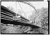
In 1929 Delaware Avenue was rerouted and a wider, higher, longer highway bridge called the Normanskill Viaduct was built across the top of the Normans Kill ravine. Starting in the spring of 1994 the Normanskill Viaduct was dismantled and replaced by a new bridge 50 feet upstream.
In the 1980s several changes occurred to the sleepy hamlet, especially on the Bethlehem side. In 1986 the original yellow brick turnpike road was paved over, the yellow bricks were first pulled up and saved though. Rockefeller Road, the main street on the Bethlehem side, was the main route south out of the hamlet and connected to Kenwood Avenue by way of a bridge built in 1914 over the now-abandoned Delaware and Hudson Railroad tracks. In 1987 the town closed the Rockefeller Road Bridge due to safety concerns, this was supported by the Normansville Neighborhood Association to remove the traffic that used Rockefeller Road as a shortcut between Kenwood and Delaware avenues. In January 1990 the older Normans Kill bridge was closed to vehicular traffic, and since then the two Normansvilles have had little exchange even though pedestrian travel over the bridge is still possible. Since then Old Delaware Avenue to Delaware Avenue is the only way in and out of Bethlehem's Normansville.
that forms the border between the city of Albany to the north and the town of Bethlehem to the south. The ravine is of clay banks with the creek flowing over a bed of slate
.
Bethlehem, New York
Bethlehem is a town in Albany County, New York, USA. The population was 33,656 at the 2010 census. The town is south of Albany. Bethlehem includes the following hamlets: Delmar, Elsmere, Slingerlands, Glenmont, Selkirk, South and North Bethlehem. U.S. Route 9W passes through the town...
and a neighborhood in the city of Albany
Albany, New York
Albany is the capital city of the U.S. state of New York, the seat of Albany County, and the central city of New York's Capital District. Roughly north of New York City, Albany sits on the west bank of the Hudson River, about south of its confluence with the Mohawk River...
, Albany County
Albany County, New York
Albany County is a county located in the U.S. state of New York, and is part of the Albany-Schenectady-Troy Metropolitan Statistical Area. The name is from the title of the Duke of York and Albany, who became James II of England . As of the 2010 census, the population was 304,204...
, New York
New York
New York is a state in the Northeastern region of the United States. It is the nation's third most populous state. New York is bordered by New Jersey and Pennsylvania to the south, and by Connecticut, Massachusetts and Vermont to the east...
. The entire area was one hamlet in Bethlehem until the portion north of the Normans Kill
Normans Kill
The Normans Kill is a creek in New York's Capital District located in Schenectady and Albany counties, which flows southeasterly from its source in the town of Duanesburg near Delanson to its mouth at the Hudson River in the town of Bethlehem. The stream creates the Watervliet Reservoir in the...
was annexed by Albany in 1916. The Delaware Turnpike once ran through both neighborhoods until 1929 with the construction of a new much higher, longer, and wider Delaware Avenue Bridge over the Normans Kill. This allowed commuters to and from Albany to bypass both Normansvilles. The original lower bridge still stands, though it has been closed to vehicular traffic since January 1990.
History
Normansville was originally called Upper Hollow for the deep ravine carved by the Normans Kill that the unincorporated village sits in. Further downstream was Lower Hollow, later named KenwoodKenwood, Albany, New York
Kenwood is a neighborhood in the city of Albany, New York. Prior to annexation by the city in 1916 a hamlet in the neighboring town of Bethlehem, also in Albany County. The hamlet once spanned both sides of the Normans Kill along the Albany and Bethlehem Turnpike...
. Upper Hollow had its start with the construction of the Delaware Turnpike in 1805 which went from the city of Albany to Otego (which then was part of Delaware County
Delaware County, New York
Delaware County is a county located in the U.S. state of New York. As of 2010 the population was 47,980. The county seat is Delhi. It is named after the Delaware River, which was named in honor of Thomas West, 3rd Baron De La Warr, appointed governor of Virginia in 1609.-History:When counties...
). At the Normans Kill (kill is Dutch for stream) the road was carried by a 100 feet (30.5 m) wooden bridge and northwest of this bridge was a toll-gate. This bridge was washed away by a freshet
Freshet
A freshet can refer to one of two things:* A flood resulting from heavy rain or a spring thaw. Whereas heavy rain often causes a flash flood, a spring thaw event is generally a more incremental process, depending upon local climate and topography...
in 1869. This was the year after the turnpike company had abandoned the road and so the town of Bethlehem built an iron bridge in its place.
Soon after the turnpike was constructed taverns and various industries began to spring up to take advantage of the power that could be harnessed from the Normans Kill's waters. Among the industries were cloth mills and saw mills, several of these mills were swept aside by the same freshet that washed away the bridge, they were quickly rebuilt but by the beginning of the 20th century the mills were abandoned. Another major industry along the Normans Kill was that of cutting ice blocks from the creek during the winter and storing it for shipping to New York City
New York City
New York is the most populous city in the United States and the center of the New York Metropolitan Area, one of the most populous metropolitan areas in the world. New York exerts a significant impact upon global commerce, finance, media, art, fashion, research, technology, education, and...
and other locations for use in iceboxes. The Pappalau Ice House on the Albany side was one of many ice houses along the Normans Kill and Hudson River
Hudson River
The Hudson is a river that flows from north to south through eastern New York. The highest official source is at Lake Tear of the Clouds, on the slopes of Mount Marcy in the Adirondack Mountains. The river itself officially begins in Henderson Lake in Newcomb, New York...
at the end of the 1800s, by 1920 it too would be abandoned as new technologies made the industry obsolete.
In 1916 Albany annexed much of the town of Bethlehem up to the Normans Kill. This included that portion of the hamlet of Normansville north of the creek. Prior to this annexation the children of Normansville attended a small school, Bethlehem District Number 11 in Normansville on the Delaware Turnpike. After the annexation those children in Albany attended the city schools, and the children remaining in Bethlehem continued to attend school in District 11. Due to the annexation and the loss of a large amount of the taxable land, the district was consolidated into neighboring District Number 7 in 1919.
In 1929 Delaware Avenue was rerouted and a wider, higher, longer highway bridge called the Normanskill Viaduct was built across the top of the Normans Kill ravine. Starting in the spring of 1994 the Normanskill Viaduct was dismantled and replaced by a new bridge 50 feet upstream.
In the 1980s several changes occurred to the sleepy hamlet, especially on the Bethlehem side. In 1986 the original yellow brick turnpike road was paved over, the yellow bricks were first pulled up and saved though. Rockefeller Road, the main street on the Bethlehem side, was the main route south out of the hamlet and connected to Kenwood Avenue by way of a bridge built in 1914 over the now-abandoned Delaware and Hudson Railroad tracks. In 1987 the town closed the Rockefeller Road Bridge due to safety concerns, this was supported by the Normansville Neighborhood Association to remove the traffic that used Rockefeller Road as a shortcut between Kenwood and Delaware avenues. In January 1990 the older Normans Kill bridge was closed to vehicular traffic, and since then the two Normansvilles have had little exchange even though pedestrian travel over the bridge is still possible. Since then Old Delaware Avenue to Delaware Avenue is the only way in and out of Bethlehem's Normansville.
Demographics
In 1886 the hamlet (including both sides of the Normans Kill) had roughly 100 individuals, 22 families, and 17 dwellings. Over 100 years later in 1993 it was estimated that the hamlet on the Bethlehem side consisted of 50 people, 19 homes, and one church.Geography
Normansville lies within and along the banks of a ravine. This ravine was carved by the Normans Kill, a creek and tributary of the Hudson RiverHudson River
The Hudson is a river that flows from north to south through eastern New York. The highest official source is at Lake Tear of the Clouds, on the slopes of Mount Marcy in the Adirondack Mountains. The river itself officially begins in Henderson Lake in Newcomb, New York...
that forms the border between the city of Albany to the north and the town of Bethlehem to the south. The ravine is of clay banks with the creek flowing over a bed of slate
Slate
Slate is a fine-grained, foliated, homogeneous metamorphic rock derived from an original shale-type sedimentary rock composed of clay or volcanic ash through low-grade regional metamorphism. The result is a foliated rock in which the foliation may not correspond to the original sedimentary layering...
.
Location
Landmarks
- Steven's Farm – Also called Normanskill Farm, a city-owned park and active farm. The park has the largest of Albany's community gardens, a dog park, hiking trails, a working farm, historic farm buildings, and a historic whipple truss bridge from 1867. The Albany Mounted Police Unit's draft horses are also kept here. The domesticated ducks and geese that call Washington Park home are brought to Stevens Farm every year for winter accommodations.
- Old Normans Kill Bridge – Original bridge across the Normans Kill, over 60 feet below the current Normanskill Viaduct. The bridge, built in 1884, is 158 feet long, paved with yellow bricks, and barely wide enough for two cars to pass. Local legend states that Edgar Allan PoeEdgar Allan PoeEdgar Allan Poe was an American author, poet, editor and literary critic, considered part of the American Romantic Movement. Best known for his tales of mystery and the macabre, Poe was one of the earliest American practitioners of the short story and is considered the inventor of the detective...
wrote about the yellow bricks the road and bridge were paved with and this was picked up by L. Frank BaumL. Frank BaumLyman Frank Baum was an American author of children's books, best known for writing The Wonderful Wizard of Oz...
who used this reference in The Wonderful Wizard of OzThe Wonderful Wizard of OzThe Wonderful Wizard of Oz is a children's novel written by L. Frank Baum and illustrated by W. W. Denslow. Originally published by the George M. Hill Company in Chicago on May 17, 1900, it has since been reprinted numerous times, most often under the name The Wizard of Oz, which is the name of...
. Local historians stress this has not been confirmed and is just local lore.
Additional reading
- Michael Lisa (June 21, 2009). "Neighborhoods: Normansville, Bethlehem". Albany Times Union. p.G7.
- Dawn Padfield (September 1, 2009). "The Yellow Brick Road". All Over Albany (Uptown/Downtown Media).