

Berlin border crossings
Encyclopedia
Potsdam Conference
The Potsdam Conference was held at Cecilienhof, the home of Crown Prince Wilhelm Hohenzollern, in Potsdam, occupied Germany, from 16 July to 2 August 1945. Participants were the Soviet Union, the United Kingdom, and the United States...
. Prior to the construction of the Berlin Wall
Berlin Wall
The Berlin Wall was a barrier constructed by the German Democratic Republic starting on 13 August 1961, that completely cut off West Berlin from surrounding East Germany and from East Berlin...
in 1961, travel between the Eastern and Western sectors of Berlin was totally uncontrolled, although restrictions were increasingly introduced by the Soviet and East German authorities at major crossings between the sectors. This free access, especially after the closure of the Inner German border, allowed the Eastern Bloc emigration and defection
Eastern Bloc emigration and defection
Eastern Bloc emigration and defection was a point of controversy during the Cold War. After World War II, emigration restrictions were imposed by countries in the Eastern Bloc, which consisted of the Soviet Union and its satellite states in Eastern and Central Europe...
to occur which resulted in the erection of the Berlin Wall.
After the construction of the Berlin Wall in 1961, border stations between East Berlin
East Berlin
East Berlin was the name given to the eastern part of Berlin between 1949 and 1990. It consisted of the Soviet sector of Berlin that was established in 1945. The American, British and French sectors became West Berlin, a part strongly associated with West Germany but a free city...
, regarded as its capital by the German Democratic Republic
German Democratic Republic
The German Democratic Republic , informally called East Germany by West Germany and other countries, was a socialist state established in 1949 in the Soviet zone of occupied Germany, including East Berlin of the Allied-occupied capital city...
but (unrecognized
Exclusive Mandate
An exclusive mandate is a government's assertion of its legitimate authority over a certain territory, part of which another government controls with stable, de facto sovereignty...
) by the Western Allies
Western Allies
The Western Allies were a political and geographic grouping among the Allied Powers of the Second World War. It generally includes the United Kingdom and British Commonwealth, the United States, France and various other European and Latin American countries, but excludes China, the Soviet Union,...
, and the sectors controlled by those three Western Allies were created. Although there were few crossings at first, more sites were built to an increasing extent over the wall's lifespan. Many crossed the wall illegally, climbing over it, sailing around it, or digging under it, while many others died while attempting to cross.
Border control procedures
Between West BerlinWest Berlin
West Berlin was a political exclave that existed between 1949 and 1990. It comprised the western regions of Berlin, which were bordered by East Berlin and parts of East Germany. West Berlin consisted of the American, British, and French occupation sectors, which had been established in 1945...
and German Democratic Republic territory, the border stations were developed very effectively on the GDR's side. (The official designation for controlled border traffic was Grenzübergangsstelle, GÜSt: border crossing site.) Border officials and customs agents would monitor incoming and outgoing traffic according to established procedures, at times with the utmost scrutiny. A strict division of labor among the various organizations was the rule. The security of the outward-facing border and of the border crossings was maintained by special security divisions of the GDR border guard troops (German abbreviation SiK, short for Sicherungskompanien).
The actual inspections of vehicle and pedestrian traffic were carried out by the passport control units (German abbreviation PKE, short for Passkontrolleinheiten). The PKE units were not under the command of the GDR border guard troops and thereby the Ministry of Defense, but the Ministry for State Security
Stasi
The Ministry for State Security The Ministry for State Security The Ministry for State Security (German: Ministerium für Staatssicherheit (MfS), commonly known as the Stasi (abbreviation , literally State Security), was the official state security service of East Germany. The MfS was headquartered...
(Division VI / Department 6, Passport Control). While on duty at the border stations, however, the PKE would wear the same uniforms as the border guard troops. For personal inspections, highly qualified and specially trained forces were used exclusively. The passports, identification cards, etc., could be transmitted from the inspection sites to a processing center using closed-circuit television and ultraviolet light, where they were recorded. From there, commands were issued using a numeric display to the passport control unit, for example "flip page", "request additional documentation", "delay processing", ask predefined questions, etc.
On the West Berlin
West Berlin
West Berlin was a political exclave that existed between 1949 and 1990. It comprised the western regions of Berlin, which were bordered by East Berlin and parts of East Germany. West Berlin consisted of the American, British, and French occupation sectors, which had been established in 1945...
side, police and customs agents were stationed. No personal inspections usually took place there.
- At the transit crossings (sites for traffic passing into the GDR en route to another country), statistical demographic data about travelers would be recorded (travel destination, etc.), and travelers would occasionally be inspected, when appropriate, for the purpose of criminal investigations (police "dragnets"Dragnet (policing)A dragnet is any system of coordinated measures for apprehending criminals or suspects; including road barricades and traffic stops, widespread DNA tests, and general increased police alertness. The term derives from a fishing technique of dragging a fishing net across the sea bottom, or through a...
).
- Freight traffic bound for other countries was subject to customs processing. Shipping to the Federal Republic of Germany was only subject to statistical record-keeping and, under certain circumstances, sealing of the cargo.
- At Checkpoint BravoCheckpoint BravoCheckpoint Bravo was the name given by the Western Allies to the main autobahn border crossing points between West Berlin and the German Democratic Republic It was known in German as Grenzübergangsstelle Drewitz-Dreilinden...
(Dreilinden) and Checkpoint CharlieCheckpoint CharlieCheckpoint Charlie was the name given by the Western Allies to the best-known Berlin Wall crossing point between East Berlin and West Berlin during the Cold War....
(Friedrichstraße), the Allied occupation forces had established checkpoints, but they were not relevant to regular personal and business traffic. They served as processing stations for military units as well as a display of military presence. Their designated authority to perform further inspections was utilized only in extremely rare cases. - Signs directed travelers passing through the GDR to report any suspicious events that might have occurred during their transit; by these means, information was to be gathered regarding, for example, the arrest of West German citizens.
Who could cross
West Germans and citizens of other Western countries could in general visit East Germany. Usually this involved application of a visa at an East German embassy several weeks in advance. Visas for day trips restricted to East Berlin were issued without previous application in a simplified procedure at the border crossing. However, East German authorities could refuse entry permits without stating a reason. In the 1980s, visitors from the western part of the city who wanted to visit the eastern part had to exchange at least DM 25 into East German currency at the poor exchange rate of 1:1. It was forbidden to export East German currency out of the East, but money not spent could be left at the border for possible future visits. Tourists crossing from the west had to also pay for a visa, which cost DM 5; West Berliners did not have to pay this.West Berliners initially could not visit East Berlin or East Germany at all. All crossing points were closed to them between 26 August 1961 and 17 December 1963. In 1963, negotiations between East and West resulted in a limited possibility for visits during the Christmas season that year (). Similar very limited arrangements were made in 1964, 1965 and 1966. In 1971, with the Four Power Agreement on Berlin
Four Power Agreement on Berlin
The Four Power Agreement on Berlin also known as the Berlin Agreement or the Quadripartite Agreement on Berlin was agreed on 3 September 1971 by the four wartime allied powers, represented by their Ambassadors...
, agreements were reached that allowed West Berliners to apply for visas to enter East Berlin and East Germany regularly, comparable to the regulations already in force for West Germans. However, East German authorities could still refuse entry permits.
East Berliners and East Germans could at first not travel to West Berlin or West Germany at all. This regulation remained in force essentially until the fall of the wall, but over the years several exceptions to these rules were introduced, the most significant being:
- Old age pensioners could travel to the West starting in 1964
- Visits of relatives for important family matters
- People who had to travel to the West for professional reasons (e.g. artists, truck drivers etc.)
However, each visit had to be applied for individually and approval was never guaranteed. In addition, even if travel was approved, GDR travelers could exchange only a very small amount of East German Mark
East German mark
The East German mark commonly called the eastern mark , in East Germany only Mark, was the currency of the German Democratic Republic . Its ISO 4217 currency code was DDM...
s into Deutsche Marks (DM), thus limiting the financial resources available for them to travel to the West. This led to the West German practice of granting a small amount of DM annually (Begrüßungsgeld
Begrüßungsgeld
Begrüßungsgeld was, from 1970 until 29 December 1989, a gift from the government of the Federal Republic of Germany to visitors from the German Democratic Republic...
, or welcome money) to GDR citizens visiting West Germany and West Berlin, to help alleviate this situation.
Citizens of other East European countries were in general subject to the same prohibition on visiting Western countries as East Germans, though the applicable exception (if any) varied from country to country.
Border crossings up to 1990

West BerlinWest BerlinWest Berlin was a political exclave that existed between 1949 and 1990. It comprised the western regions of Berlin, which were bordered by East Berlin and parts of East Germany. West Berlin consisted of the American, British, and French occupation sectors, which had been established in 1945...
- East BerlinEast BerlinEast Berlin was the name given to the eastern part of Berlin between 1949 and 1990. It consisted of the Soviet sector of Berlin that was established in 1945. The American, British and French sectors became West Berlin, a part strongly associated with West Germany but a free city...
There were several border crossingBorder Crossing
Border Crossing may refer to:* Border Crossing , an album by saxophonist Mike Osborne.* Border Crossing , a UK hip hop collective musical group.* Border Crossing , a 2001 novel by English author Pat Barker....
s between East and West Berlin:
- Bornholmer Straße border crossingBornholmer Straße border crossingThe Bornholmer Straße border crossing was one of the border crossings between East Berlin and West Berlin between 1961 to 1990. The crossing was named after the street on which it is located, Bornholmer Straße...
, on Bornholmer Straße over the Bösebrücke between Berlin-Prenzlauer BergPrenzlauer BergPrenzlauer Berg is a locality of Berlin, in the borough of Pankow.Until 2001, Prenzlauer Berg was a borough of Berlin; in that year it was included in the borough of Pankow....
and Berlin-Wedding (opened 1961).
-
- For West Berliners, citizens of the Federal Republic, GDR citizens, and diplomats (by road)
- Brandenburg GateBrandenburg GateThe Brandenburg Gate is a former city gate and one of the most well-known landmarks of Berlin and Germany. It is located west of the city centre at the junction of Unter den Linden and Ebertstraße, immediately west of the Pariser Platz. It is the only remaining gate of a series through which...
between Berlin-Tiergarten and Berlin-Mitte, opened on 13 August 1961. On 14 August West Berliners gathered on the western side of the gate to demonstrate against the Berlin Wall. Under the pretext that Western demonstrations required it, the East closed the checkpoint the same day, 'until further notice', a situation that was to last until 22 December 1989. - Chausseestraße/Reinickendorfer Straße between Berlin-Wedding and Berlin-Mitte
- For West Berliners and GDR citizens (by road)
- InvalidenstraßeInvalidenstraßeThe Invalidenstraße is a street in Berlin, Germany. It runs east to west for through the districts of Mitte and Moabit. The street originally connected three important railway stations in the northern city centre: the Stettiner Bahnhof , the Hamburger Bahnhof and the Lehrter Bahnhof, the...
/Sandkrugbrücke between TiergartenTiergartenTiergarten is a locality within the borough of Mitte, in central Berlin . Notable for the great and homonymous urban park, before German reunification, it was a part of West Berlin...
and Berlin-Mitte- For West Berliners and GDR citizens (by road)
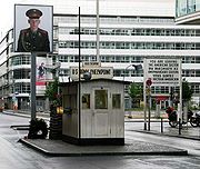
- Checkpoint CharlieCheckpoint CharlieCheckpoint Charlie was the name given by the Western Allies to the best-known Berlin Wall crossing point between East Berlin and West Berlin during the Cold War....
/FriedrichstraßeFriedrichstraßeThe Friedrichstraße is a major culture and shopping street in central Berlin, forming the core of the Friedrichstadt neighborhood. It runs from the northern part of the old Mitte district to the Hallesches Tor in the district of Kreuzberg...
between Berlin-Mitte and Berlin-Kreuzberg (opened 1961)- For foreigners, diplomats, Allied military personnel and GDR citizens (by road)
- Heinrich-Heine-Straße/Prinzenstraße between Berlin-Mitte and Berlin-Kreuzberg
- For citizens of the Federal Republic, GDR citizens and diplomats (by road)
- This was sometimes referred to as Checkpoint Delta
- OberbaumbrückeOberbaumbrückeThe Oberbaum Bridge is a double-deck bridge crossing Berlin's River Spree, considered one of the city landmarks. It links Friedrichshain and Kreuzberg, former boroughs that were divided by the Berlin Wall, and has become an important symbol of Berlin’s unity....
between FriedrichshainFriedrichshainFriedrichshain is a part of Berlin's borough of Friedrichshain-Kreuzberg, and like Kreuzberg across the river it has its own distinct character, with the result that the new double name is hardly ever used outside government administration. From its creation in 1920 until Berlin's 2001...
and Berlin-Kreuzberg (opened 1963)- For West Berliners and GDR citizens (pedestrians)
- Sonnenallee between NeuköllnNeuköllnNeukölln is the eighth borough of Berlin, located in the southeastern part of the city and was part of the former American sector under the Four-Power occupation of the city...
and TreptowTreptowTreptow is a former borough in the southeast of Berlin. It merged with Köpenick to form Treptow-Köpenick in 2001.-Geography:The district was composed by the localities of Alt-Treptow, Plänterwald, Baumschulenweg, Niederschöneweide, Johannisthal, Adlershof, Altglienicke and Bohnsdorf....
- For West Berliners and GDR citizens (by road)
In addition, entirely located in East Berlin (reached by streetcar, underground, or railroad):
- Friedrichstraße station (opened 1961)
- For West Berliners, citizens of the Federal Republic, foreigners, diplomats, transit travelers and GDR citizens (rail/pedestrian)
West Berlin - GDR
- Glienicke BridgeGlienicke bridgeThe Glienicke bridge is a bridge on the edge of Berlin that spans the Havel River to connect the cities of Potsdam and Berlin near Klein Glienicke...
over the HavelHavelThe Havel is a river in north-eastern Germany, flowing through the German states of Mecklenburg-Vorpommern, Brandenburg, Berlin and Saxony-Anhalt. It is a right tributary of the Elbe river and in length...
from Berlin-Wannsee to PotsdamPotsdamPotsdam is the capital city of the German federal state of Brandenburg and part of the Berlin/Brandenburg Metropolitan Region. It is situated on the River Havel, southwest of Berlin city centre....
- Open to general traffic until 1952.
- From 1952 on, open only for access by the western Allied Military Liaison MissionsMilitary Liaison MissionsThe Military Liaison Missions arose from reciprocal agreements formed immediately after the Second World War between the Western allied nations and the USSR...
. Civilians with special permission were later allowed to cross the bridge on foot. - From 1953-07-03 on, the bridge was closed as one of the last routes connecting Berlin with the surrounding area for civilian traffic.
- It became well known in particular because three exchanges of captured agents took place there between the American and SovietSoviet UnionThe Soviet Union , officially the Union of Soviet Socialist Republics , was a constitutionally socialist state that existed in Eurasia between 1922 and 1991....
superpowers.
- Lichtenrade/Mahlow (Federal Road 96Bundesstraße 96The Bundesstraße 96 is a federal highway in Germany. It begins in Zittau in the Saxony, close to the border triangle between Germany, Poland, and the Czech Republic, heads north through Berlin and ends in Sassnitz on the island of Rügen in the Baltic Sea...
), only for garbage trucks of the Berlin sanitation department and automobiles on service trips from West Berlin to the dump in SchöneicheSchöneicheSchöneiche is a municipality in the Oder-Spree District of Brandenburg, Germany. It is situated directly at the edge to Berlin/Köpenick.-External links:...
. - Waltersdorf Chaussee/Rudow Chaussee, besides its function for transit to and from the Berlin-Schönefeld airportBerlin-Schönefeld International AirportBerlin-Schönefeld Airport is an international airport located near the town of Schönefeld in Brandenburg, directly at the southern border of Berlin and southeast of the city centre. Schönefeld was the major civil airport of East Germany , and the only airport serving East Berlin...
, was also opened for passage of West Berliners into the GDR. The crossing was little known, as only its transit function was mentioned in guidebooks. - In Kohlhasenbrück, for access to the SteinstückenSteinstückenSteinstücken, a small settlement with approximately 200 inhabitants, is the southernmost territory of the Berlin borough of Steglitz-Zehlendorf, belonging to Wannsee...
exclave, and only for the use of its residents. This crossing was abolished after the 1971 territorial exchange, when East Germany ceded the interjacent tract of land to West Berlin. - Bürgerablage Beach, for access to the exclaves Erlengrund and Fichtewiese, two allotment clubsAllotment (gardening)An allotment garden, often called simply an allotment, is a plot of land made available for individual, non-professional gardening. Such plots are formed by subdividing a piece of land into a few or up to several hundreds of land parcels that are assigned to individuals or families...
, only for use by allotmentiers there. The crossing was abolished after the 1988 territorial exchange, when East Germany ceded two tracts of interjacent land to West Berlin.
Crossings for transit traffic
Road crossings
These crossings could be used for passage on the prescribed transit highways and for travel within the SOZ/GDR:
- DreilindenNikolasseeNikolassee is a locality of Berlin in the borough of Steglitz-Zehlendorf. Until the latter was created in 2001, Nikolassee was part of the borough of Zehlendorf.-History:...
(Allied Checkpoint BravoCheckpoint BravoCheckpoint Bravo was the name given by the Western Allies to the main autobahn border crossing points between West Berlin and the German Democratic Republic It was known in German as Grenzübergangsstelle Drewitz-Dreilinden...
)/DrewitzPotsdamPotsdam is the capital city of the German federal state of Brandenburg and part of the Berlin/Brandenburg Metropolitan Region. It is situated on the River Havel, southwest of Berlin city centre....
: The Autobahn Crossing Checkpoint DreilindenNikolasseeNikolassee is a locality of Berlin in the borough of Steglitz-Zehlendorf. Until the latter was created in 2001, Nikolassee was part of the borough of Zehlendorf.-History:...
and Border Crossing Station (GÜSt) DrewitzPotsdamPotsdam is the capital city of the German federal state of Brandenburg and part of the Berlin/Brandenburg Metropolitan Region. It is situated on the River Havel, southwest of Berlin city centre....
was for travel and freight traffic. Even after this portion of the autobahn was rebuilt and the crossing station was relocated on 1969-10-15, the names were retained. Berlin-ZehlendorfZehlendorf (Berlin)Zehlendorf is a locality within the borough of Steglitz-Zehlendorf in Berlin. Before Berlin's 2001 administrative reform Zehlendorf was a borough in its own right, consisting of the locality of Zehlendorf as well as Wannsee, Nikolassee and Dahlem...
/KleinmachnowKleinmachnowKleinmachnow is a municipality in the Potsdam-Mittelmark district, in Brandenburg, Germany.-Geography:It is situated southwest of the centre of Berlin, immediately neighbouring the borough of Steglitz-Zehlendorf, and east of Potsdam...
would have been more correct.- to the Federal Republic, in the following directions:
- MarienbornMarienbornMarienborn is a village and a former municipality in the Börde district in Saxony-Anhalt, Germany. Since 1 January 2010, it has been part of the municipality of Sommersdorf. It is about southwest of Haldensleben...
/ HelmstedtHelmstedtHelmstedt is a city located at the eastern edge of the German state of Lower Saxony. It is the capital of the District of Helmstedt. Helmstedt has 26,000 inhabitants . In former times the city was also called Helmstädt....
(Lower SaxonyLower SaxonyLower Saxony is a German state situated in north-western Germany and is second in area and fourth in population among the sixteen states of Germany...
, Hannover; Allied Checkpoint Alpha) - Hirschberg / Rudolphstein (BavariaBavariaBavaria, formally the Free State of Bavaria is a state of Germany, located in the southeast of Germany. With an area of , it is the largest state by area, forming almost 20% of the total land area of Germany...
, HofHof, GermanyHof is a city located on the banks of the Saale in the northeastern corner of the German state of Bavaria, in the Franconia region, at the Czech border and the forested Fichtelgebirge and Frankenwald upland regions....
, Nürnberg, München) - WarthaWartha (Eisenach)Wartha is a town in the subdivision of Wartha-Göringen which forms part of the independent-city district of Eisenach in Thuringia state, Germany.Near Wartha was a former major road border crossing on the Inner German border between East and West Germany...
/ HerleshausenHerleshausen-Location:Herleshausen lies north of a section of the boundary with Thuringia in the thickly wooded area between the Ringgau and the Thuringian Forest with the Thuringian Forest Nature Park in the southeast...
(toward HesseHesseHesse or Hessia is both a cultural region of Germany and the name of an individual German state.* The cultural region of Hesse includes both the State of Hesse and the area known as Rhenish Hesse in the neighbouring Rhineland-Palatinate state...
, Frankfurt am Main)
- Marienborn
- into CzechoslovakiaCzechoslovakiaCzechoslovakia or Czecho-Slovakia was a sovereign state in Central Europe which existed from October 1918, when it declared its independence from the Austro-Hungarian Empire, until 1992...
:- Zinnwald / Cinovec
- to Poland:
- Pomellen / Kołbaskowo (Kolbitzow) (in the direction of SzczecinSzczecinSzczecin , is the capital city of the West Pomeranian Voivodeship in Poland. It is the country's seventh-largest city and the largest seaport in Poland on the Baltic Sea. As of June 2009 the population was 406,427....
, GdańskGdanskGdańsk is a Polish city on the Baltic coast, at the centre of the country's fourth-largest metropolitan area.The city lies on the southern edge of Gdańsk Bay , in a conurbation with the city of Gdynia, spa town of Sopot, and suburban communities, which together form a metropolitan area called the...
) - Frankfurt (Oder)Frankfurt (Oder)Frankfurt is a town in Brandenburg, Germany, located on the Oder River, on the German-Polish border directly opposite the town of Słubice which was a part of Frankfurt until 1945. At the end of the 1980s it reached a population peak with more than 87,000 inhabitants...
/ SlubiceSlubiceSłubice is a border town in the Lubusz Voivodeship of western Poland. Located on the Oder river, directly opposite the city of Frankfurt in Germany, of which it was a part until 1945 . As of the 2008 census, the town had a total population of 17,000...
(toward central Poland, WarsawWarsawWarsaw is the capital and largest city of Poland. It is located on the Vistula River, roughly from the Baltic Sea and from the Carpathian Mountains. Its population in 2010 was estimated at 1,716,855 residents with a greater metropolitan area of 2,631,902 residents, making Warsaw the 10th most...
) - Forst (toward southern Poland, (in the direction of Wrocław, KatowiceKatowiceKatowice is a city in Silesia in southern Poland, on the Kłodnica and Rawa rivers . Katowice is located in the Silesian Highlands, about north of the Silesian Beskids and about southeast of the Sudetes Mountains.It is the central district of the Upper Silesian Metropolis, with a population of 2...
, KrakówKrakówKraków also Krakow, or Cracow , is the second largest and one of the oldest cities in Poland. Situated on the Vistula River in the Lesser Poland region, the city dates back to the 7th century. Kraków has traditionally been one of the leading centres of Polish academic, cultural, and artistic life...
)
- Pomellen / Kołbaskowo (Kolbitzow) (in the direction of Szczecin
- toward Scandinavia:
- SassnitzSassnitzSassnitz is a town on the Jasmund peninsula, Rügen Island, in the Federal State of Mecklenburg-Vorpommern, Germany. The population as of 2007 was 10,747....
by Baltic sea passage to Sweden (TrelleborgTrelleborgTrelleborg is a locality and the seat of Trelleborg Municipality, Skåne County, Sweden with 25,643 inhabitants in 2005. It is the southernmost town in Sweden.-History:...
), Denmark (RønneRønneRønne is the largest town on the Danish island of Bornholm in the Baltic Sea. It has a population of 13,904 . Once a municipality in its own right, it is now the administrative centre of the Bornholm municipality....
) - RostockRostockRostock -Early history:In the 11th century Polabian Slavs founded a settlement at the Warnow river called Roztoc ; the name Rostock is derived from that designation. The Danish king Valdemar I set the town aflame in 1161.Afterwards the place was settled by German traders...
/ WarnemündeWarnemündeWarnemünde is a sea resort and northmost district of Rostock in Mecklenburg-Vorpommern, situated on the Baltic Sea in the northeast of Germany at the estuary of the river Warnow.- History :...
by Baltic sea passage to Denmark (GedserGedserGedser is a town at the southern tip of the Danish island of Falster in the Guldborgsund Municipality in Sjælland region. It is the southernmost town in Denmark. The town has a population of 809...
), passengers and crews of passenger ships.
- Sassnitz
- In addition the only trans-border bus line of the BVG, bus line 99, passed through this crossing from the Wannsee streetcar station to Potsdam-Babelsberg (autobahn exit) and back. Until 1989-11-09 only buses without an upper deck or advertising were allowed; afterwards, conventional double-decker buses with advertising would pass as well, due to increased traffic and the freedom of passage after the Berlin Wall fell.
- to the Federal Republic, in the following directions:
- HeerstraßeHeerstraße (Berlin)The Heerstraße runs from Theodor-Heuss-Platz in Berlin-Charlottenburg until the western city border of Berlin in the locality of Staaken in the borough of Spandau. In its intire length it is part of the Bundesstraße 5; from Theodor-Heuss-Platz to Wilhelmstraße it is also Bundesstraße 2...
in Berlin-Staaken / Staaken-West (1951 - 1982, previously in DallgowDallgow-DöberitzDallgow-Döberitz is a municipality in the Havelland district, in Brandenburg, Germany.-Geography:It consists of the villages Dallgow-Döberitz, Rohrbeck and Seeburg. To the east it shares border with the Spandau borough of Berlin. Neighbouring Brandenburg municipalities are Falkensee in the north...
):- HorstHorst, LauenburgHorst is a municipality in the district of Lauenburg, in Schleswig-Holstein, Germany.-History:During excavations near Horst some Slavic relicts were found, dating back to the 7th Century....
/ LauenburgLauenburg/ElbeLauenburg/Elbe is a town in the state of Schleswig-Holstein, Germany. It is situated at the northern bank of the river Elbe, east of Hamburg. It is the southernmost town of Schleswig-Holstein. Lauenburg belongs to the Kreis of Herzogtum Lauenburg and had a population of 11,900 as of 2002...
(B 5 / F 5: to northern GermanyNorthern Germany- Geography :The key terrain features of North Germany are the marshes along the coastline of the North Sea and Baltic Sea, and the geest and heaths inland. Also prominent are the low hills of the Baltic Uplands, the ground moraines, end moraines, sandur, glacial valleys, bogs, and Luch...
, HamburgHamburg-History:The first historic name for the city was, according to Claudius Ptolemy's reports, Treva.But the city takes its modern name, Hamburg, from the first permanent building on the site, a castle whose construction was ordered by the Emperor Charlemagne in AD 808...
)- This crossing offered the only option for driving to the Federal Republic with vehicles not permitted on the autobahn (e.g., bicycles, mopeds, tractors, and other specialized vehicles), on condition that one make the trip without interruption (overnight stays, lengthy breaks).
- This crossing was later closed and replaced by an autobahn connection through TegelTegelTegel is a locality in the Berlin borough of Reinickendorf on the shore of Lake Tegel. The Tegel locality, the second largest in area of the 95 Berlin districts, also includes the neighbourhood of Saatwinkel.-History:...
. With this change, the possibility of going through the GDR with other vehicles ended.
- Horst
- Berlin-Heiligensee/StolpeHohen NeuendorfHohen Neuendorf is a town in the Oberhavel district, in Brandenburg, Germany. It is located north west of Berlin.-Geography:Hohen Neuendorf is situated upon the Havel river and is bordered by the Berlin area Frohnau to the south, Muehlenbeck to the east, Birkenwerder and Oranienburg to the north,...
: Autobahn Crossing Checkpoint Berlin-Heiligensee and StolpeHohen NeuendorfHohen Neuendorf is a town in the Oberhavel district, in Brandenburg, Germany. It is located north west of Berlin.-Geography:Hohen Neuendorf is situated upon the Havel river and is bordered by the Berlin area Frohnau to the south, Muehlenbeck to the east, Birkenwerder and Oranienburg to the north,...
in Hohen NeuendorfHohen NeuendorfHohen Neuendorf is a town in the Oberhavel district, in Brandenburg, Germany. It is located north west of Berlin.-Geography:Hohen Neuendorf is situated upon the Havel river and is bordered by the Berlin area Frohnau to the south, Muehlenbeck to the east, Birkenwerder and Oranienburg to the north,...
- to the Federal Republic, in the direction of:
- ZarrentinZarrentinZarrentin is a town in the Ludwigslust-Parchim district, in Mecklenburg-Western Pomerania, Germany. It is situated on the Schaalsee lake, 19 km southeast of Ratzeburg, and 34 km west of Schwerin.-History:...
/ GudowGudowGudow is a municipality in the district of Lauenburg, in Schleswig-Holstein, Germany.-History:Between 1982 and 1990 Gudow served as West German inner German border crossing for cars travelling along Bundesautobahn 24 between the East German Democratic Republic, or West Berlin and the West German...
(northern GermanyNorthern Germany- Geography :The key terrain features of North Germany are the marshes along the coastline of the North Sea and Baltic Sea, and the geest and heaths inland. Also prominent are the low hills of the Baltic Uplands, the ground moraines, end moraines, sandur, glacial valleys, bogs, and Luch...
, HamburgHamburg-History:The first historic name for the city was, according to Claudius Ptolemy's reports, Treva.But the city takes its modern name, Hamburg, from the first permanent building on the site, a castle whose construction was ordered by the Emperor Charlemagne in AD 808...
- Zarrentin
- to Poland
- Pomellen / Kołbaskowo (Kolbitzow) (toward SzczecinSzczecinSzczecin , is the capital city of the West Pomeranian Voivodeship in Poland. It is the country's seventh-largest city and the largest seaport in Poland on the Baltic Sea. As of June 2009 the population was 406,427....
, GdańskGdanskGdańsk is a Polish city on the Baltic coast, at the centre of the country's fourth-largest metropolitan area.The city lies on the southern edge of Gdańsk Bay , in a conurbation with the city of Gdynia, spa town of Sopot, and suburban communities, which together form a metropolitan area called the...
)
- Pomellen / Kołbaskowo (Kolbitzow) (toward Szczecin
- to Scandinavia
- SassnitzSassnitzSassnitz is a town on the Jasmund peninsula, Rügen Island, in the Federal State of Mecklenburg-Vorpommern, Germany. The population as of 2007 was 10,747....
by Baltic sea passage to Sweden (TrelleborgTrelleborgTrelleborg is a locality and the seat of Trelleborg Municipality, Skåne County, Sweden with 25,643 inhabitants in 2005. It is the southernmost town in Sweden.-History:...
), Denmark (RønneRønneRønne is the largest town on the Danish island of Bornholm in the Baltic Sea. It has a population of 13,904 . Once a municipality in its own right, it is now the administrative centre of the Bornholm municipality....
) - RostockRostockRostock -Early history:In the 11th century Polabian Slavs founded a settlement at the Warnow river called Roztoc ; the name Rostock is derived from that designation. The Danish king Valdemar I set the town aflame in 1161.Afterwards the place was settled by German traders...
/ WarnemündeWarnemündeWarnemünde is a sea resort and northmost district of Rostock in Mecklenburg-Vorpommern, situated on the Baltic Sea in the northeast of Germany at the estuary of the river Warnow.- History :...
by Baltic sea passage to Denmark (GedserGedserGedser is a town at the southern tip of the Danish island of Falster in the Guldborgsund Municipality in Sjælland region. It is the southernmost town in Denmark. The town has a population of 809...
), passengers and crews of passenger ships.
- Sassnitz
- to the Federal Republic, in the direction of:
- LichtenradeLichtenradeLichtenrade is a German locality within the borough of Tempelhof-Schöneberg, Berlin. Until 2001 it was part of the former borough of Tempelhof.-History:The locality was first mentioned in 1375, named Lichtenrode...
/ GroßbeerenGroßbeerenGroßbeeren is a municipality in the district of Teltow-Fläming in the German state of Brandenburg.-Geography:Located about 3 km south of Berlin's city limits. It includes the localities of Diedersdorf, Heinersdorf and Kleinbeeren.-History:...
: This crossing planned but never realised. Intended to be developed as an autobahn border control station for transit travelers.
Rail crossings
- Berlin-Wannsee/GriebnitzseePotsdam Griebnitzsee railway stationPotsdam Griebnitzsee is a railway station in the western outskirts of Berlin, the capital city of Germany. The station is located in the east of the Babelsberg suburb of the city of Potsdam in the state of Brandenburg, and about outside the Berlin city boundary...
(for passenger traffic) and SteinstückenSteinstückenSteinstücken, a small settlement with approximately 200 inhabitants, is the southernmost territory of the Berlin borough of Steglitz-Zehlendorf, belonging to Wannsee...
/DrewitzDrewitzDrewitz is a village and a former municipality in the Jerichower Land district, in Saxony-Anhalt, Germany. Since 1 January 2010, it is part of the town Möckern....
Station (for freight traffic)- MarienbornMarienbornMarienborn is a village and a former municipality in the Börde district in Saxony-Anhalt, Germany. Since 1 January 2010, it has been part of the municipality of Sommersdorf. It is about southwest of Haldensleben...
/HelmstedtHelmstedtHelmstedt is a city located at the eastern edge of the German state of Lower Saxony. It is the capital of the District of Helmstedt. Helmstedt has 26,000 inhabitants . In former times the city was also called Helmstädt....
(Hannover, western GermanyWestern GermanyThe geographic term Western Germany is used to describe a region in the west of Germany. The exact area defined by the term is not constant, but it usually includes, but does not have the borders of, North Rhine-Westphalia and Hesse...
) - SchwanheideSchwanheideSchwanheide is a municipality in the Ludwigslust-Parchim district, in Mecklenburg-Vorpommern, Germany.-History:Between 1945 and 1990 Schwanheide served as East German inner German border crossing for rail transport...
/BüchenBüchenBüchen is a municipality in the district of Lauenburg, in Schleswig-Holstein, Germany. It is situated on the Elbe-Lübeck Canal, approx. 13 km northeast of Lauenburg/Elbe, and 45 km east of Hamburg....
(HamburgHamburg-History:The first historic name for the city was, according to Claudius Ptolemy's reports, Treva.But the city takes its modern name, Hamburg, from the first permanent building on the site, a castle whose construction was ordered by the Emperor Charlemagne in AD 808...
, northern GermanyNorthern Germany- Geography :The key terrain features of North Germany are the marshes along the coastline of the North Sea and Baltic Sea, and the geest and heaths inland. Also prominent are the low hills of the Baltic Uplands, the ground moraines, end moraines, sandur, glacial valleys, bogs, and Luch...
, 1961 - 1976) - GerstungenGerstungenGerstungen is a municipality in the Wartburgkreis district of Thuringia, Germany.-History:Between 1945 and 1990 Gerstungen served as East German inner German border crossing on the Thuringian Railway...
/BebraBebraBebra is a small town in Hersfeld-Rotenburg district in northeastern Hesse, Germany.-Location:Bebra lies some 45 km south of Kassel on the Fulda. The town is easy to find on most maps thanks to its prominent location on the Fuldaknie...
(western GermanyWestern GermanyThe geographic term Western Germany is used to describe a region in the west of Germany. The exact area defined by the term is not constant, but it usually includes, but does not have the borders of, North Rhine-Westphalia and Hesse...
, HesseHesseHesse or Hessia is both a cultural region of Germany and the name of an individual German state.* The cultural region of Hesse includes both the State of Hesse and the area known as Rhenish Hesse in the neighbouring Rhineland-Palatinate state...
, Frankfurt am Main) - ProbstzellaProbstzellaProbstzella is a municipality in the district Saalfeld-Rudolstadt, in Thuringia, Germany.-History:Between 1945 and 1990 Probstzella station served as East German inner German border crossing for rail transport...
/LudwigsstadtLudwigsstadtLudwigsstadt is a municipality in the district of Kronach, in the Upper Franconian region of Bavaria, Germany. It is situated at the state's northern border in the Franconian Forest mountain range, north of Kronach, and south of Saalfeld in Thuringia, the only Bavarian municipality north of the...
(southern Germany, HofHof, GermanyHof is a city located on the banks of the Saale in the northeastern corner of the German state of Bavaria, in the Franconia region, at the Czech border and the forested Fichtelgebirge and Frankenwald upland regions....
, Nürnberg, München)
- Marienborn
- Berlin-Spandau/Staaken (SOZ / 'GDR') (restricted to freight only from 1961 to 1976; during those years, passenger traffic was diverted via Berlin-Wannsee/GriebnitzseePotsdam Griebnitzsee railway stationPotsdam Griebnitzsee is a railway station in the western outskirts of Berlin, the capital city of Germany. The station is located in the east of the Babelsberg suburb of the city of Potsdam in the state of Brandenburg, and about outside the Berlin city boundary...
)- SchwanheideSchwanheideSchwanheide is a municipality in the Ludwigslust-Parchim district, in Mecklenburg-Vorpommern, Germany.-History:Between 1945 and 1990 Schwanheide served as East German inner German border crossing for rail transport...
/BüchenBüchenBüchen is a municipality in the district of Lauenburg, in Schleswig-Holstein, Germany. It is situated on the Elbe-Lübeck Canal, approx. 13 km northeast of Lauenburg/Elbe, and 45 km east of Hamburg....
(HamburgHamburg-History:The first historic name for the city was, according to Claudius Ptolemy's reports, Treva.But the city takes its modern name, Hamburg, from the first permanent building on the site, a castle whose construction was ordered by the Emperor Charlemagne in AD 808...
, northern GermanyNorthern Germany- Geography :The key terrain features of North Germany are the marshes along the coastline of the North Sea and Baltic Sea, and the geest and heaths inland. Also prominent are the low hills of the Baltic Uplands, the ground moraines, end moraines, sandur, glacial valleys, bogs, and Luch...
)
- Schwanheide
- Zoologischer Garten StationBerlin Zoologischer Garten railway stationBerlin Zoologischer Garten station was the central transport facility in West Berlin during the division of the city, and thereafter for the western central area of Berlin until opening of the new Berlin Central Station on 28 May 2006...
/Friedrichstraße Station- ČSSRCzechoslovakiaCzechoslovakia or Czecho-Slovakia was a sovereign state in Central Europe which existed from October 1918, when it declared its independence from the Austro-Hungarian Empire, until 1992...
, Poland, Scandinavia- Furthermore, many train connections ended at the OstbahnhofBerlin OstbahnhofBerlin Ostbahnhof is a mainline railway station in Berlin, Germany. It is in Friedrichshain, now part of Friedrichshain-Kreuzberg district, and has undergone several name changes in its history. It was known as Berlin Hauptbahnhof from 1987 to 1998, a name now applied to Berlin's new central station...
(east station). Very few passenger coaches passed through (e.g. Paris - Moscow), and in general one had to change trains at the Ostbahnhof (then the Berlin main station) or in the Berlin-Lichtenberg station.
- Furthermore, many train connections ended at the Ostbahnhof
- ČSSR
Waterways
The numerous border crossings on waterways (e.g.,
Spree
Spree
The Spree is a river that flows through the Saxony, Brandenburg and Berlin states of Germany, and in the Ústí nad Labem region of the Czech Republic...
, Havel
Havel
The Havel is a river in north-eastern Germany, flowing through the German states of Mecklenburg-Vorpommern, Brandenburg, Berlin and Saxony-Anhalt. It is a right tributary of the Elbe river and in length...
, Teltow Canal
Teltow Canal
The Teltow Canal, also known as the Teltowkanal in German, is a canal to the south of Berlin, the capital city of Germany. The canal lies in both the states of Berlin and Brandenburg, and at points forms the boundary between the two...
) were only open to commercial freight traffic. Recreational boats had to be loaded onto ships or towed overland.
- Tiefer SeeTiefer SeeTiefer See is a lake in the Mecklenburgische Seenplatte district in Mecklenburg-Vorpommern, Germany. At an elevation of 62.9 m, its surface area is 0.76 km²....
/ Glienicke Lake (1954 - 1961) This crossing was not relevant for traffic to and from West BerlinWest BerlinWest Berlin was a political exclave that existed between 1949 and 1990. It comprised the western regions of Berlin, which were bordered by East Berlin and parts of East Germany. West Berlin consisted of the American, British, and French occupation sectors, which had been established in 1945...
. - Dreilinden / KleinmachnowKleinmachnowKleinmachnow is a municipality in the Potsdam-Mittelmark district, in Brandenburg, Germany.-Geography:It is situated southwest of the centre of Berlin, immediately neighbouring the borough of Steglitz-Zehlendorf, and east of Potsdam...
, Teltow CanalTeltow CanalThe Teltow Canal, also known as the Teltowkanal in German, is a canal to the south of Berlin, the capital city of Germany. The canal lies in both the states of Berlin and Brandenburg, and at points forms the boundary between the two...
(from 1981 on) - Teufelssee Canal / HennigsdorfHennigsdorfHennigsdorf is a town in the district of Oberhavel, in Brandenburg, Germany. It is situated north-west of Berlin, just across the city border, which is formed mainly by the Havel river.-History:...
(only traffic to and from GDR destinations and transit traffic (Poland), not to the Federal Republic) - Potsdam-Nedlitz / JungfernseeJungfernseeThe Jungfernsee is located north of Potsdam, Germany. It was a glacial kettle and is now part of the River Havel, which runs along its southeastern shore, which is also the only part of its shores that is in Berlin...
- Crossings within the Berlin city limits
Air travel
To and from Berlin-Schönefeld AirportBerlin-Schönefeld International Airport
Berlin-Schönefeld Airport is an international airport located near the town of Schönefeld in Brandenburg, directly at the southern border of Berlin and southeast of the city centre. Schönefeld was the major civil airport of East Germany , and the only airport serving East Berlin...
for air travel:
- Waltersdorfer Chaussee/Rudower Chaussee (transfer bus to and from West Berlin)
also, within East Berlin territory (access via streetcar, U-bahn
Rapid transit
A rapid transit, underground, subway, elevated railway, metro or metropolitan railway system is an electric passenger railway in an urban area with a high capacity and frequency, and grade separation from other traffic. Rapid transit systems are typically located either in underground tunnels or on...
or rail):
- Friedrichstraße StationFriedrichstraßeThe Friedrichstraße is a major culture and shopping street in central Berlin, forming the core of the Friedrichstadt neighborhood. It runs from the northern part of the old Mitte district to the Hallesches Tor in the district of Kreuzberg...
(starting in 1961)
At the Berlin-Tempelhof
Tempelhof International Airport
Berlin Tempelhof Airport was an airport in Berlin, Germany, situated in the south-central borough of Tempelhof-Schöneberg. The airport ceased operating in 2008 in the process of establishing Schönefeld as the sole commercial airport for Berlin....
and Berlin-Tegel airports there were border crossings manned by West Berlin police and customs. These were not located in territory controlled by the GDR. In addition to processing for international air travel, the personal documents of travelers between West Berlin and the Federal Republic were inspected.
Miscellaneous crossings
The various illegal or unofficial border crossings are not reliably documented:- those constructed between the East and West by refugees and those who assisted them, mostly underground. Many of these were discovered and destroyed.
- those constructed by, e.g., the Ministry for State SecurityStasiThe Ministry for State Security The Ministry for State Security The Ministry for State Security (German: Ministerium für Staatssicherheit (MfS), commonly known as the Stasi (abbreviation , literally State Security), was the official state security service of East Germany. The MfS was headquartered...
and other clandestine organizations, in order to transfer people unobserved between East and West.
Changes in 1989 and 1990
In the time between the fall of the Berlin Wall on 9 November 1989 and the abolition of all border controls on 1 July 1990, numerous additional border crossings were built for interim use. Because of their symbolic value, the most famous of these were Glienicke BridgeGlienicke bridge
The Glienicke bridge is a bridge on the edge of Berlin that spans the Havel River to connect the cities of Potsdam and Berlin near Klein Glienicke...
, Bernauer Straße
Bernauer Straße
Bernauer Straße is a street of Berlin situated between the localities of Gesundbrunnen and Mitte, today both belonging to the Mitte borough. It runs from the Mauerpark at the corner of Prenzlauer Berg to the Nordbahnhof...
, Potsdamer Platz
Potsdamer Platz
Potsdamer Platz is an important public square and traffic intersection in the centre of Berlin, Germany, lying about one kilometre south of the Brandenburg Gate and the Reichstag , and close to the southeast corner of the Tiergarten park...
, and the Brandenburg Gate
Brandenburg Gate
The Brandenburg Gate is a former city gate and one of the most well-known landmarks of Berlin and Germany. It is located west of the city centre at the junction of Unter den Linden and Ebertstraße, immediately west of the Pariser Platz. It is the only remaining gate of a series through which...
.
The opening of the Brandenburg Gate was merely a public-relations formality which took place on 22 December 1989 at the request of then-Chancellor Helmut Kohl
Helmut Kohl
Helmut Josef Michael Kohl is a German conservative politician and statesman. He was Chancellor of Germany from 1982 to 1998 and the chairman of the Christian Democratic Union from 1973 to 1998...
. Hundreds of television crews from all over the world had anticipated this historic event for weeks.
West Germans and West Berliners were allowed visa-free travel to the East Berlin and East Germany starting 23 December 1989. Until then, they could only visit under restrictive conditions that involved application for a visa several days or weeks in advance and obligatory exchange of at least 25 DM per day of their planned stay. Thus, in the weeks between 9 November 1989 and 23 December 1989, East Germans could travel more freely than Westerners as they have been able to cross into West Berlin with just passport checks.
The controls were abandoned on 1 July 1990, the day of the currency union and before the actual reunification
German reunification
German reunification was the process in 1990 in which the German Democratic Republic joined the Federal Republic of Germany , and when Berlin reunited into a single city, as provided by its then Grundgesetz constitution Article 23. The start of this process is commonly referred by Germans as die...
of Germany on 3 October 1990. In the months after the fall of the Wall, border crossings between the East and the West had become more and more irrelevant.
Today, a few portions of the structures have been retained as a memorial.
| A chronological list of Berlin border crossings opened until 30 June 1990 | |||||
|---|---|---|---|---|---|
| No | Date | Time | Location | Areas linked | Notes |
| 1 | 10 November 1989 | 08:00 | Kirchhainer Damm | Mahlow/Berlin-Lichtenrade (F 96/B 96) | Already in use for sanitation trucks, was opened to private citizens |
| 2 | 18:00 | Glienicke Bridge Glienicke bridge The Glienicke bridge is a bridge on the edge of Berlin that spans the Havel River to connect the cities of Potsdam and Berlin near Klein Glienicke... |
Potsdam/Berlin-Wannsee | Already in use for Allied personnel, was opened to private citizens | |
| 3 | 11 November 1989 | 08:00 | Eberswalder Straße/Bernauer Straße Bernauer Straße Bernauer Straße is a street of Berlin situated between the localities of Gesundbrunnen and Mitte, today both belonging to the Mitte borough. It runs from the Mauerpark at the corner of Prenzlauer Berg to the Nordbahnhof... |
Prenzlauer Berg/Berlin-Wedding | |
| 4 | Jannowitzbrücke subway station | Berlin-Mitte/Subway line U8 | Previously a ghost station Ghost station Ghost stations is the usual English translation for the German word Geisterbahnhöfe. This term was used to describe certain stations on Berlin's U-Bahn and S-Bahn metro networks that were closed during the period of Berlin's division during the Cold War... |
||
| 5 | 13:00 | Puschkinallee/Schlesische Straße | Treptow/Berlin-Kreuzberg | ||
| 6 | 12 November 1989 | 08:00 | Potsdamer Platz Potsdamer Platz Potsdamer Platz is an important public square and traffic intersection in the centre of Berlin, Germany, lying about one kilometre south of the Brandenburg Gate and the Reichstag , and close to the southeast corner of the Tiergarten park... |
Berlin-Mitte/Tiergarten | |
| 7 | 13 November 1989 | 08:00 | Wollankstraße | Pankow/Berlin-Wedding | |
| 8 | 18:00 | Falkenseer Chaussee | Falkensee/Berlin-Spandau | ||
| 9 | 14 November 1989 | 08:00 | Philipp-Müller-Allee /Ostpreußendamm | Teltow/Berlin-Lichterfelde | |
| 10 | Stubenrauchstraße - Massantebrücke | Berlin-Johannisthal/Berlin-Rudow | |||
| 11 | 11 December 1989 | Karl-Marx-Straße/Benschallee | Kleinmachnow/Berlin-Nikolassee-Düppel | ||
| 12 | 22 December 1989 | Rosenthaler Platz subway station Rosenthaler Platz (Berlin U-Bahn) Rosenthaler Platz is a Berlin U-Bahn station located on the .1930 opened and designed by A.Grenander in color red. Closed in 1961 to 1989.-References:... |
Berlin-Mitte/Subway line U8 | Previously a ghost station Ghost station Ghost stations is the usual English translation for the German word Geisterbahnhöfe. This term was used to describe certain stations on Berlin's U-Bahn and S-Bahn metro networks that were closed during the period of Berlin's division during the Cold War... |
|
| 13 | Brandenburg Gate Brandenburg Gate The Brandenburg Gate is a former city gate and one of the most well-known landmarks of Berlin and Germany. It is located west of the city centre at the junction of Unter den Linden and Ebertstraße, immediately west of the Pariser Platz. It is the only remaining gate of a series through which... |
Berlin-Mitte/Tiergarten | |||
| 14 | 3 January 1990 | Karl-Marx-Straße/Buckower Damm | Groß Ziethen/Berlin-Buckow | ||
| 15 | 13 January 1990 | Ruppiner Chaussee | Hennigsdorf-Stolpe Süd/Berlin-Heiligensee-Schulzendorf | ||
| 16 | 22 January 1990 | Griebnitzsee station Potsdam Griebnitzsee railway station Potsdam Griebnitzsee is a railway station in the western outskirts of Berlin, the capital city of Germany. The station is located in the east of the Babelsberg suburb of the city of Potsdam in the state of Brandenburg, and about outside the Berlin city boundary... |
Was already in use as a transit crossing, then was opened for the newly inaugurated commuter train Potsdam-Wannsee | ||
| 17 | 30 January 1990 | Potsdamer Chaussee | Groß-Glienicke/Berlin-Kladow-Groß Glienicke | ||
| 18 | 17 February 1990 | Berliner Straße/Oranienburger Chaussee (F 96/B 96) | Hohen-Neuendorf/Frohnau | ||
| 19 | 3 March 1990 | Oranienburger Chaussee/Berliner Straße (through "Entenschnabel" F 96/B 96) | Glienicke-Nordbahn/Hermsdorf (Berlin) | ||
| 20 | 17 March 1990 | Rudolf-Breitscheid-Straße/Neue Kreisstraße | Potsdam-Babelsberg/Berlin-Wannsee-Kohlhasenbrück | ||
| 21 | Böttcherberg | Potsdam-Klein-Glienicke/Berlin-Wannsee | |||
| 22 | 23 March 1990 | Lindenstraße | Berlin-Mitte/Berlin-Kreuzberg | ||
| 23 | 31 March 1990 | Zehlendorfer Damm/Machnower Straße | Kleinmachnow/Berlin-Zehlendorf | ||
| 24 | 6 April 1990 | Lichtenrader Straße/Groß Ziethener Straße | Groß Ziethen/Berlin-Lichtenrade | ||
| 25 | Arcostraße/Beethovenstraße | Mahlow/Berlin-Lichtenrade | |||
| 26 | 7 April 1990 | Brunnenstraße | Berlin-Mitte/Berlin-Wedding | ||
| 27 | Kopenhagener Straße | Berlin-Niederschönhausen-Wilhelmsruh/Berlin-Reinickendorf | |||
| 28 | 12 April 1990 | Schilling Bridge/Köpenicker Straße | Berlin-Mitte/Berlin-Kreuzberg | ||
| 29 | Elsenstraße | Treptow/Berlin-Neukölln | |||
| 30 | Bernauer Straße subway station | Berlin-Mitte/Berlin-Wedding | Previously a ghost station, it was opened without border controls, with direct access to West Berlin | ||
| 31 | Rudower Chaussee/Groß-Ziethener Chaussee | Groß Ziethen/Berlin-Rudow | |||
| 32 | 27 May 1990 | Torweg | Staaken-West/Berlin-Staaken | ||
| 33 | 8 June 1990 | Dammweg | Berlin-Baumschulenweg/Berlin-Neukölln | ||
| 34 | 11 June 1990 | Behmstraßen Bridge | Prenzlauer Berg/Berlin-Wedding | ||
| 35 | 17 June 1990 | Wilhelmsruher Damm | Berlin-Rosenthal/Berlin-Wittenau-Märkisches Viertel | ||
| 36 | 23 June 1990 | Berliner Allee/Schönwalder Allee | Schönwalde/Berlin-Spandau | ||
| 37 | Knesebeck Bridge | Teltow/Berlin-Zehlendorf-Schönow | |||
| 38 | 30 June 1990 | Großbeeren-Heinersdorf/Marienfelder Allee (F 100/B 101) | Berlin-Marienfelde | ||
Remaining border controls
Today the only remaining border crossings in Berlin are located at Tegel and SchönefeldBerlin-Schönefeld International Airport
Berlin-Schönefeld Airport is an international airport located near the town of Schönefeld in Brandenburg, directly at the southern border of Berlin and southeast of the city centre. Schönefeld was the major civil airport of East Germany , and the only airport serving East Berlin...
airports (Schönefeld located outside Berlin city limits) and all Cold War
Cold War
The Cold War was the continuing state from roughly 1946 to 1991 of political conflict, military tension, proxy wars, and economic competition between the Communist World—primarily the Soviet Union and its satellite states and allies—and the powers of the Western world, primarily the United States...
-specific border control procedures have disappeared altogether. They are staffed by German Federal Police
German Federal Police
The Bundespolizei is a uniformed federal police force in Germany. It is subordinate to the Federal Ministry of the Interior...
and Customs for normal international traffic screening purposes.